Building height inversion based on the complex shadow measurement method
LI Zhixin1(), JI Song1(), FAN Dazhao1, GAO Ding1, LI Yongjian1, WANG Ren2
1. Institute of Geospatial Information, Information Engineering University, Zhengzhou 450001, China 2. Shandong Wuzheng Group Co.,Ltd., Rizhao 276800, China
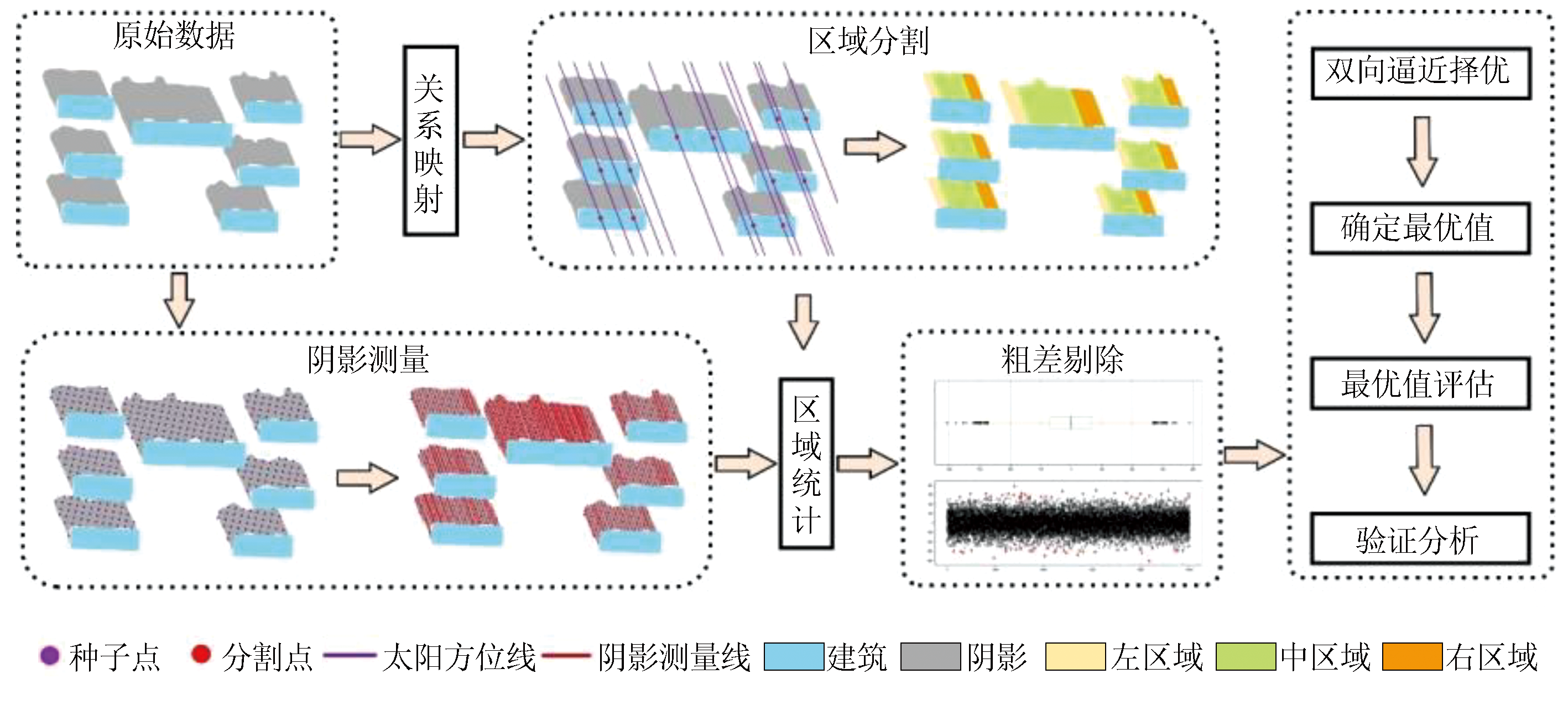
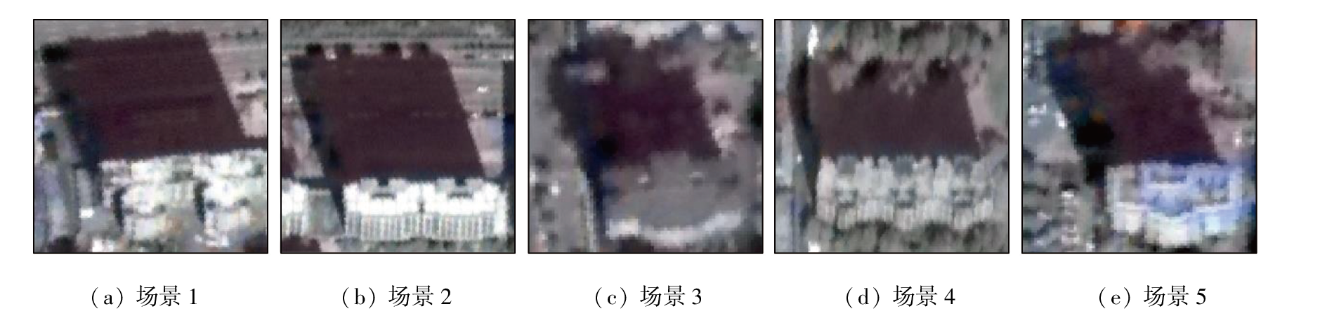
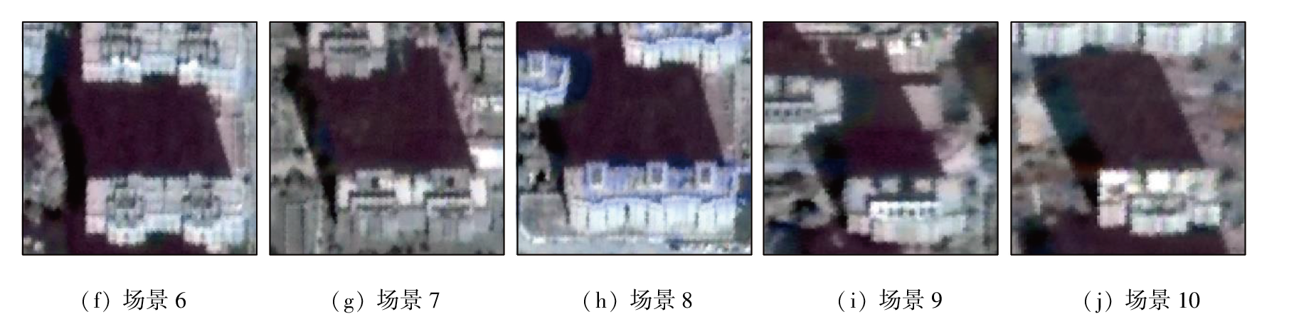
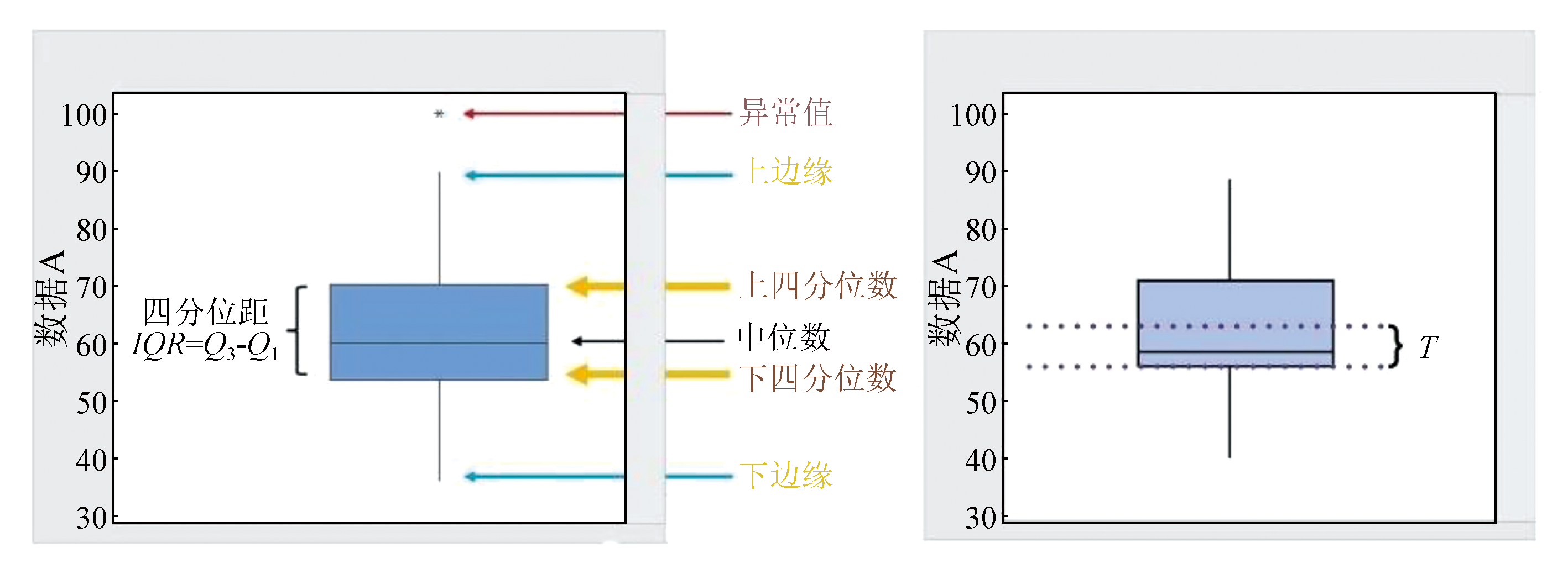
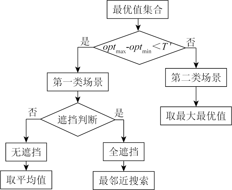
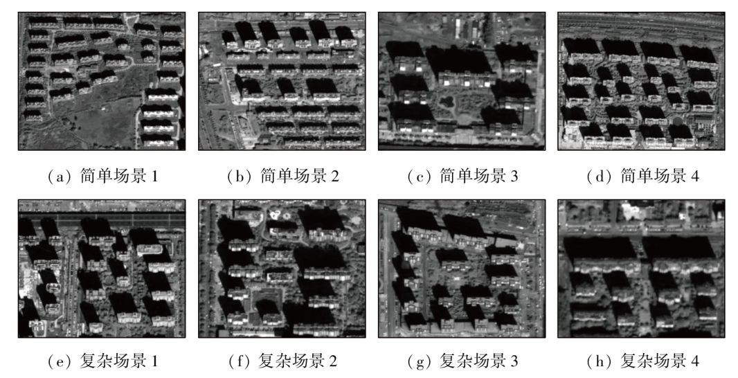
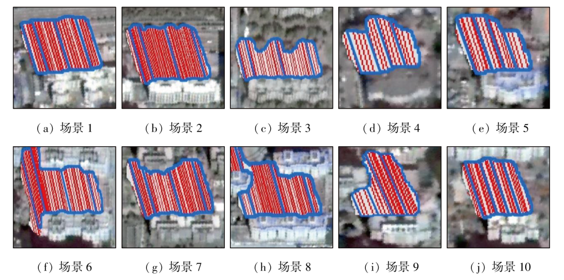
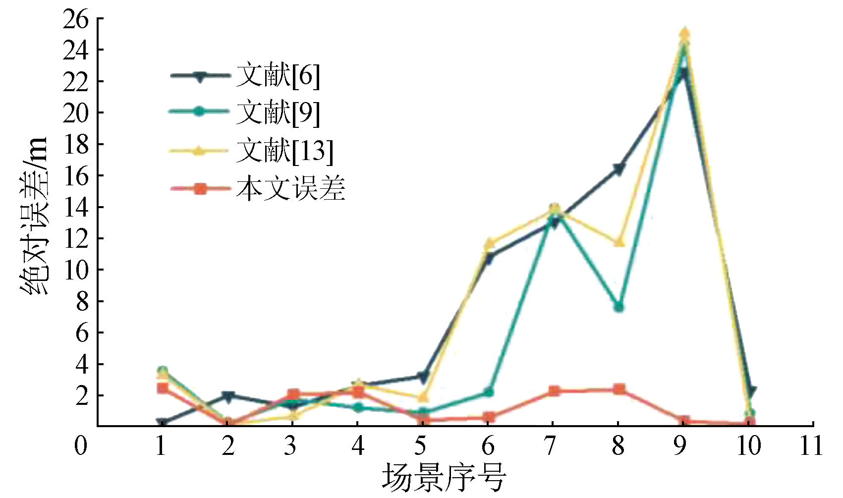
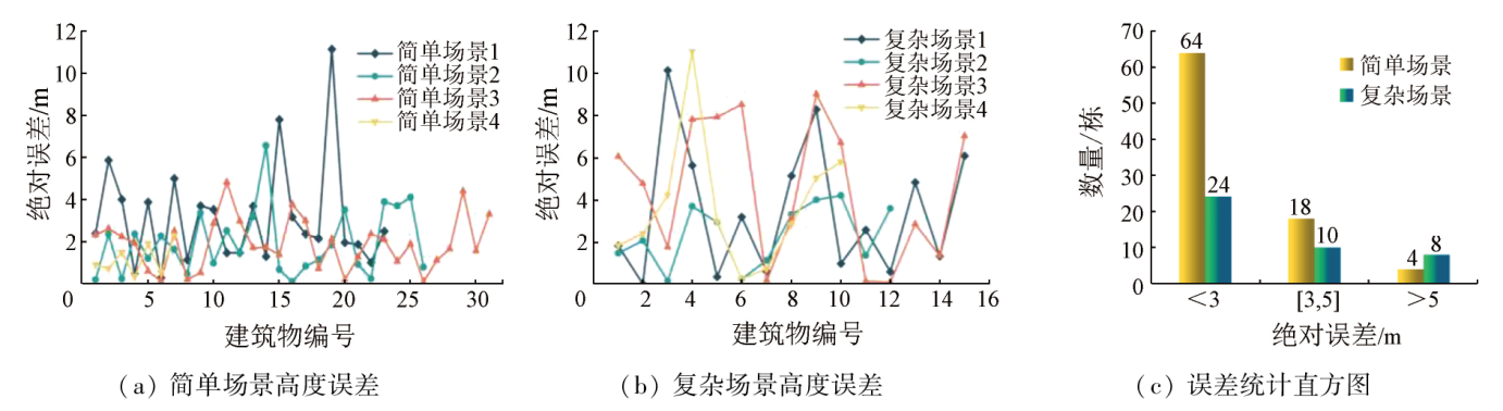
Building heights are necessary for urban informatics, providing a significant basis for the planning and early warning of risks for urban construction. The shadow method, which can measure the heights of urban buildings on a large scale at a low cost, faces challenges such as low efficiency, accuracy, and robustness in building height inversion in complex shadow scenes. This study proposed a measurement method for these scenes. First, the shadows were measured and delineated using the fishing net method combined with multiple constraints. Second, the shadow lengths of all the zones divided were obtained, and the optimal values were determined using the quartile method and the bidirectional approximation strategy. Third, the shadow lengths were determined through a comprehensive assessment of the optimal values of all zones. The results show that 90.6% of building heights calculated using the new method exhibited absolute errors ranging from 0 to 5 m. Therefore, this method features elevated accuracy of building height inversion for various complex shadow scenes, laying a basis for research into the inversion and expansion of urban building heights.
李志新, 纪松, 范大昭, 高定, 李永建, 王刃. 基于复杂阴影测量方法的建筑物高度反演[J]. 自然资源遥感, 2024, 36(3): 108-116.
LI Zhixin, JI Song, FAN Dazhao, GAO Ding, LI Yongjian, WANG Ren. Building height inversion based on the complex shadow measurement method. Remote Sensing for Natural Resources, 2024, 36(3): 108-116.
Huang H, Chen P, Xu X, et al. Estimating building height in China from ALOS AW3D30[J]. ISPRS Journal of Photogrammetry and Remote Sensing, 2022, 185:146-157.
[2]
Qin R. Change detection on LOD 2 building models with very high resolution spaceborne stereo imagery[J]. ISPRS Journal of Photogrammetry and Remote Sensing, 2014, 96:179-192.
[3]
Venter Z S, Brousse O, Esau I, et al. Hyperlocal mapping of urban air temperature using remote sensing and crowdsourced weather data[J]. Remote Sensing of Environment, 2020, 242:111791.
[4]
Zhang Z, Qian Z, Zhong T, et al. Vectorized rooftop area data for 90 cities in China[J]. Scientific Data, 2022, 9(1):66.
doi: 10.1038/s41597-022-01168-x
pmid: 35236863
Yue Z X, Zhang Y J, Duan Y S, et al. DEM assisted shadow detection and topography correction of satellite remote sensing images in mountainous area[J]. Acta Geodaetica et Cartographica Sinica, 2018, 47(1):113-122.
doi: 10.11947/j.AGCS.2018.20170194
Chen T, Zhu S Y, Zhang G X, et al. A comparative study on building height extraction based on the shadow information in high resolution remote sensing image and stereo images[J]. Journal of Geo-Information Science, 2016, 18(9):1267-1275.
[7]
Irvin R B, McKeown D M. Methods for exploiting the relationship between buildings and their shadows in aerial imagery[J]. IEEE Transactions on Systems,Man,and Cybernetics, 1989, 19(6):1564-1575.
[8]
Shettigara V K, Sumerling G M. Height determination of extended objects using shadows in SPOT images[J]. Photogrammetric Engineering and Remote Sensing, 1998, 64(1):35-43.
[9]
Wang X, Yu X, Ling F. Building heights estimation using ZY3 data:A case study of Shanghai,China[C]// 2014 IEEE Geoscience and Remote Sensing Symposium.IEEE, 2014:1749-1752.
[10]
Turker M, Sumer E. Building-based damage detection due to earthquake using the watershed segmentation of the post-event aerial images[J]. International Journal of Remote Sensing, 2008, 29(11):3073-3089.
[11]
Shao Y, Taff G N, Walsh S J. Shadow detection and building-height estimation using IKONOS data[J]. International Journal of Remote Sensing, 2011, 32(22):6929-6944.
[12]
Liasis G, Stavrou S. Satellite images analysis for shadow detection and building height estimation[J]. ISPRS Journal of Photogrammetry and Remote Sensing, 2016, 119:437-450.
[13]
张豪. 基于深度学习的遥感影像建筑物阴影提取方法研究[D]. 成都: 西南交通大学, 2020.
Zhang H. Research on building shadow extraction method of Remote sensing image based on deep learning[D]. Chengdu: Southwest Jiaotong University, 2020.
Wang Y G, Liu H P. The calculation of building shadow length using statistical average method based on corner shortest distance[J]. Remote Sensing for Land and Resources, 2008, 20(3):32-36.doi:10.6046/gtzyyg.2008.03.08.
[16]
Xie Y, Feng D, Xiong S, et al. Multi-scene building height estimation method based on shadow in high resolution imagery[J]. Remote Sensing, 2021, 13(15):2862.
Li Z X, Wang M F, Jia W J, et al. A method for identifying the number of building floors basod on shadow information[J]. Remote Sensing for Natural Resources, 2023, 35(3):97-106.doi:10.6046/zrzyyg.2022226.
[18]
陈冲. 基于高分影像阴影的多场景建筑物高度反演研究[D]. 西安: 西安科技大学, 2020.
Chen C. Building heigh information extraction from shadow derived from highresolution satellite image based on scene classification[D]. Xi'an: Xi'an University of Science and Technology, 2020.
Xie Y K. Research on building height information extraction method based on shadow of high-resolution image in multiple scenes[D]. Chengdu: Southwest Jiaotong University, 2018.
[20]
张珩. 高分影像建筑物阴影检测方法及其高度反演研究[D]. 成都: 西南交通大学, 2017.
Zhang H. Research on buildings shadow detection method and height inversion with high resolution sensed image[D]. Chengdu: Southwest Jiaotong University, 2017.
Chen J. Discussion on the algorithm of quartile in statistical processing of ability verification results[J]. China Metrology, 2012(12):94-95.
[22]
王杰茜. 基于高度反演的建筑物阴影分类方法研究[D]. 成都: 西南交通大学, 2021.
Wang J X. Research on building shadow classification method based on height inversion[D]. Chengdu: Southwest Jiaotong University, 2021.
[23]
Luo S, Li H, Shen H. Deeply supervised convolutional neural network for shadow detection based on a novel aerial shadow imagery dataset[J]. ISPRS Journal of Photogrammetry and Remote Sensing, 2020, 167:443-457.
 2024, Vol. 36
  ), 纪松1(