Information extraction of landslides based on high-resolution remote sensing images and an improved U-Net model: A case study of Wenchuan, Sichuan
BAI Shi1(), TANG Panpan1(), MIAO Zhao2, JIN Caifeng3, ZHAO Bo1, WAN Haoming1
1. Research Center of Big Data Technology, Nanhu Laboratory, Jiaxing 314002, China 2. Institute of Exploration Technology Chinese Academy of Geological Sciences, Chengdu 611734, China 3. School of Architectural Engineering, Jiaxing Nanhu University, Jiaxing 314001, China
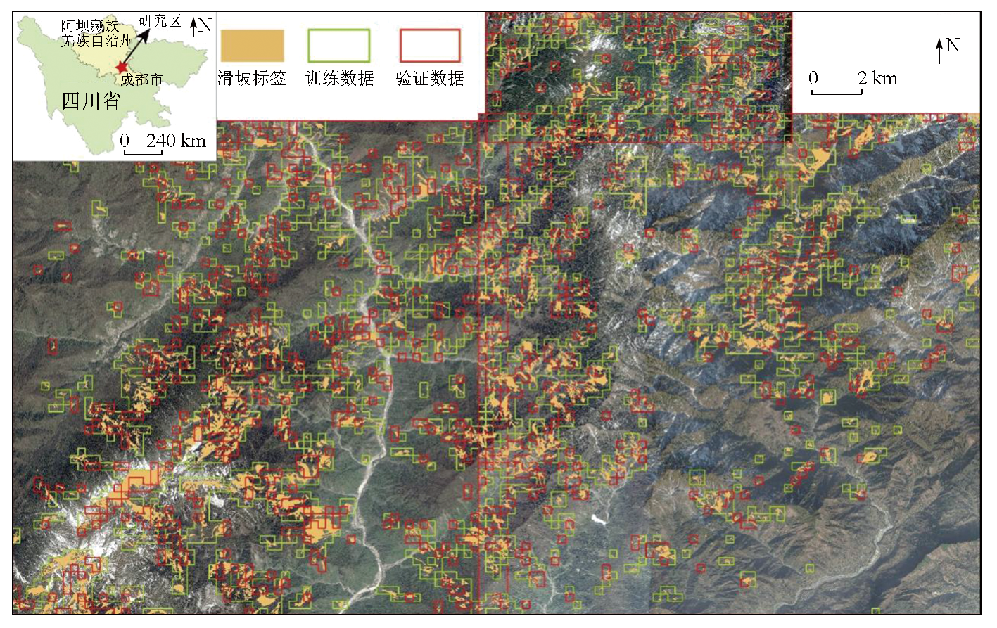
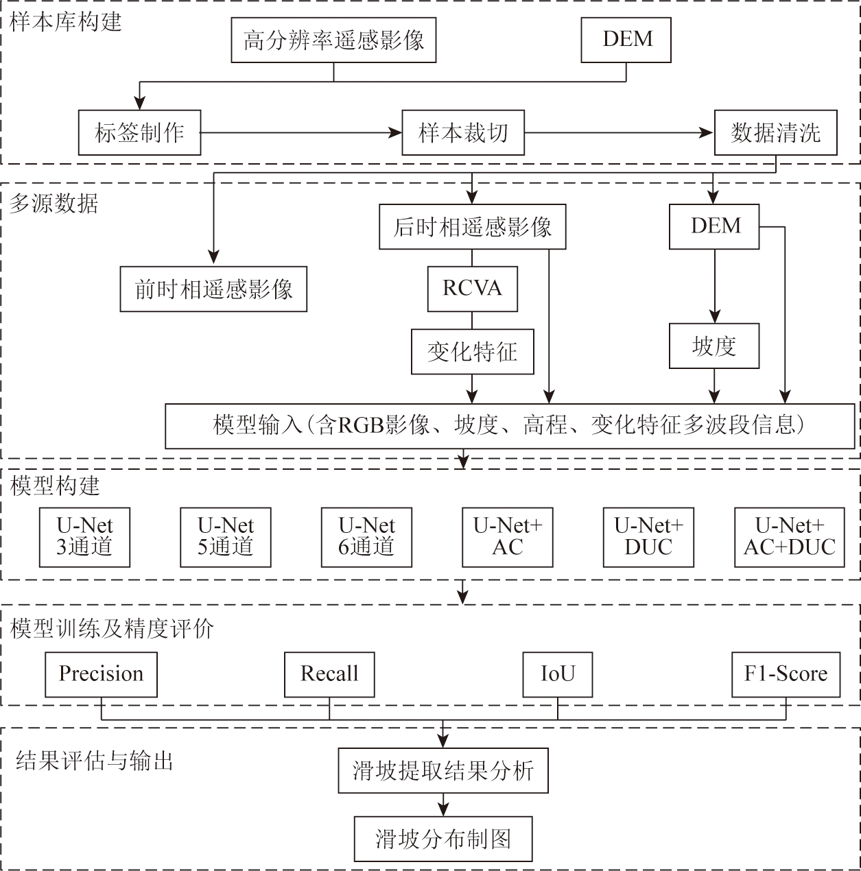
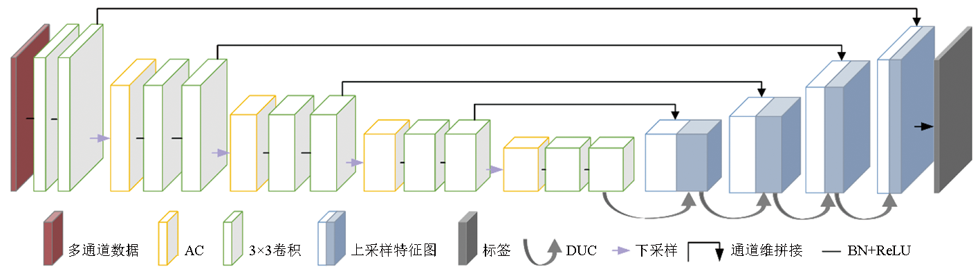
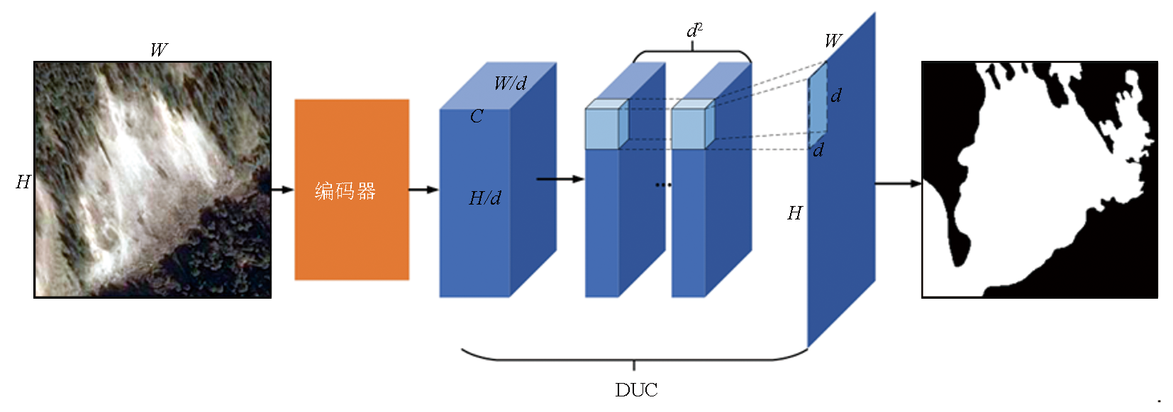
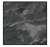
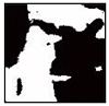
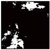
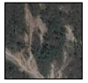
Rapid identification and detection of landslides can both meet the requirement of timely responses to disasters and hold great significance for loss assessment and rescue post-disaster. This study proposed a deep learning-based automatic information extraction method for landslides to improve their detection accuracy. Specifically, the model input of this method includes the remote sensing images of the target areas, data from digital elevation models, and variation characteristics extracted using robust change vector analysis (RCVA). Furthermore, a U-Net model integrating dense upsampling and asymmetric convolution is designed to improve the identification accuracy. Taking Wenchuan, Sichuan Province as the study area, this study designed experiments to test the pixel-level image segmentation accuracy of landslides using different data combinations and methods. The results indicate that the improved U-Net model proposed in the study can produce the optimal image segmentation results of landslides.
白石, 唐攀攀, 苗朝, 金彩凤, 赵博, 万昊明. 基于高分辨率遥感影像和改进U-Net模型的滑坡提取——以汶川地区为例[J]. 自然资源遥感, 2024, 36(3): 96-107.
BAI Shi, TANG Panpan, MIAO Zhao, JIN Caifeng, ZHAO Bo, WAN Haoming. Information extraction of landslides based on high-resolution remote sensing images and an improved U-Net model: A case study of Wenchuan, Sichuan. Remote Sensing for Natural Resources, 2024, 36(3): 96-107.
Li H, Xu Q, He Y, et al. Modeling and predicting reservoir landslide displacement with deep belief network and EWMA control charts:A case study in Three Gorges Reservoir[J]. Landslides, 2020, 17(3):693-707.
[2]
Mondini A C, Guzzetti F, Chang K T, et al. Landslide failures detection and mapping using synthetic aperture Radar:Past,present and future[J]. Earth-Science Reviews, 2021, 216:103574.
[3]
Hoeppe P. Trends in weather related disasters:Consequences for insurers and society[J]. Weather and Climate Extremes, 2016, 11:70-79.
[4]
Haque U, da Silva P F, Devoli G, et al. The human cost of global warming:Deadly landslides and their triggers (1995—2014)[J]. Science of the Total Environment, 2019, 682:673-684.
[5]
Huggel C, Clague J J, Korup O. Is climate change responsible for changing landslide activity in high mountains?[J]. Earth Surface Processes and Landforms, 2012, 37(1):77-91.
Yan Q, Li H, Jing L H, et al. Automatic extraction algorithm of seismic landslide information based on after-calamity high-resolution remote sensing image[J]. Laser & Optoelectronics Progress, 2017, 54(11):112801.
Zhu J, Tang C. An overview of remote sensing applications for landslide research in China[J]. Remote Sensing Technology and Application, 2012, 27(3):458-464.
[8]
Bellotti F, Bianchi M, Colombo D, et al. Advanced InSAR techniques to support landslide monitoring[C]//Mathematics of Planet Earth.Berlin, Heidelberg:Springer, 2014:287-290.
[9]
Guzzetti F, Mondini A C, Cardinali M, et al. Landslide inventory maps:New tools for an old problem[J]. Earth-Science Reviews, 2012, 112(1/2):42-66.
[10]
Dou J, Yunus A P, Bui D T, et al. Improved landslide assessment using support vector machine with bagging,boosting,and stacking ensemble machine learning framework in a mountainous watershed,Japan[J]. Landslides, 2020, 17(3):641-658.
[11]
Barlow J, Martin Y, Franklin S E. Detecting translational landslide scars using segmentation of Landsat ETM+ and DEM data in the northern Cascade Mountains,British Columbia[J]. Canadian Journal of Remote Sensing, 2003, 29(4):510-517.
[12]
Rau J Y, Jhan J P, Rau R J. Semiautomatic object-oriented landslide recognition scheme from multisensor optical imagery and DEM[J]. IEEE Transactions on Geoscience and Remote Sensing, 2014, 52(2):1336-1349.
[13]
Rib H T, Liang T. Recognition and identification[J]. Transportation Research Board Special Report, 1978,(176).
[14]
Nichol J E, Shaker A, Wong M S. Application of high-resolution stereo satellite images to detailed landslide hazard assessment[J]. Geomorphology, 2006, 76(1/2):68-75.
Li C H, Hao L N, Xu Q, et al. Object-oriented hierarchical identification of earthquake-induced landslides based on high-resolution remote sensing images[J]. Remote Sensing for Natural Resources, 2023, 35(1):74-80.doi:10.6046/zrzyyg.2022013.
Zhang Y, Ming D P, Zhao W Y, et al. The extraction and analysis of Luding earthquake-induced landslide based on high-resolution optical satellite images[J]. Remote Sensing for Natural Resources, 2023, 35(1):161-170.doi:10.6046/zrzyyg.2022434.
Li S, Deng B K, Xu H Q, et al. Fast interpretation methods of landslides triggered by earthquake using remote sensing imagery[J]. Remote Sensing Information, 2015, 30(4):25-28.
[18]
Marjanović M, Kovaĉević M, Bajat B, et al. Landslide susceptibility assessment using SVM machine learning algorithm[J]. Engineering Geology, 2011, 123(3):225-234.
[19]
Lee S. Application of logistic regression model and its validation for landslide susceptibility mapping using GIS and remote sensing data[J]. International Journal of Remote Sensing, 2005, 26(7):1477-1491.
[20]
Stumpf A, Kerle N. Object-oriented mapping of landslides using random forests[J]. Remote Sensing of Environment, 2011, 115(10):2564-2577.
[21]
Goetz J N, Brenning A, Petschko H, et al. Evaluating machine learning and statistical prediction techniques for landslide susceptibility modeling[J]. Computers & Geosciences, 2015, 81:1-11.
[22]
He K, Zhang X, Ren S, et al. Identity mappings in deep residual networks[M]//Leibe B,Matas J,Sebe N,et al.,Eds.Computer Vision-ECCV 2016. Cham: Springer International Publishing, 2016:630-645.
[23]
Chen L C, Papandreou G, Kokkinos I, et al. DeepLab:Semantic image segmentation with deep convolutional nets,atrous convolution,and fully connected CRFs[J]. IEEE Transactions on Pattern Analysis and Machine Intelligence, 2018, 40(4):834-848.
[24]
Girshick R. Fast R-CNN[C]// 2015 IEEE International Conference on Computer Vision (ICCV).Santiago,Chile.IEEE, 2015:1440-1448.
[25]
Längkvist M, Kiselev A, Alirezaie M, et al. Classification and segmentation of satellite orthoimagery using convolutional neural networks[J]. Remote Sensing, 2016, 8(4):329.
[26]
Mahdianpari M, Salehi B, Rezaee M, et al. Very deep convolutional neural networks for complex land cover mapping using multispectral remote sensing imagery[J]. Remote Sensing, 2018, 10(7):1119.
[27]
Ghorbanzadeh O, Blaschke T, Gholamnia K, et al. Evaluation of different machine learning methods and deep-learning convolutional neural networks for landslide detection[J]. Remote Sensing, 2019, 11(2):196.
Yang Z Y, Han L Y, Zheng X X, et al. Landslide identification using remote sensing images and DEM based on convolutional neural network:A case study of loess landslide[J]. Remote Sensing for Natural Resources, 2022, 34(2):224-230.doi:10.6046/zrzyyg.2021204.
[29]
Ye C, Li Y, Cui P, et al. Landslide detection of hyperspectral remote sensing data based on deep learning with constrains[J]. IEEE Journal of Selected Topics in Applied Earth Observations and Remote Sensing, 2019, 12(12):5047-5060.
[30]
Wang T, Liu M, Zhang H, et al. Landslide detection based on improved YOLOv5 and satellite images[C]// 2021 4th International Conference on Pattern Recognition and Artificial Intelligence (PRAI).Yibin,China.IEEE, 2021: 367-371.
[31]
Yu B, Chen F, Xu C, et al. Matrix SegNet:A practical deep learning framework for landslide mapping from images of different areas with different spatial resolutions[J]. Remote Sensing, 2021, 13(16):3158.
[32]
Zhang M, Shi W, Chen S, et al. Deep multiple instance learning for landslide mapping[J]. IEEE Geoscience and Remote Sensing Letters, 2021, 18(10):1711-1715.
[33]
Liu P, Wei Y, Wang Q, et al. Research on post-earthquake landslide extraction algorithm based on improved U-Net model[J]. Remote Sensing, 2020, 12(5):894.
[34]
Meena S R, Soares L P, Grohmann C H, et al. Landslide detection in the Himalayas using machine learning algorithms and U-Net[J]. Landslides, 2022, 19(5):1209-1229.
[35]
Su Z, Chow J K, Tan P S, et al. Deep convolutional neural network-based pixel-wise landslide inventory mapping[J]. Landslides, 2021, 18(4):1421-1443.
[36]
Ghorbanzadeh O, Shahabi H, Crivellari A, et al. Landslide detection using deep learning and object-based image analysis[J]. Landslides, 2022, 19(4):929-939.
[37]
Oktay O, Schlemper J, Le Folgoc L, et al. Attention U-Net:Learning where to look for the pancreas[EB/OL]. 2018:arXiv:1804.03999. https://arxiv.org/abs/1804.03999.pdf.
[38]
Zhou Z, Siddiquee M M R, Tajbakhsh N, et al. UNet++:Redesigning skip connections to exploit multiscale features in image segmentation[J]. IEEE Transactions on Medical Imaging, 2020, 39(6):1856-1867.
Long Y J, Li W L, Huang R Q, et al. Automatic extraction and evolution trend analysis of landslides in Mianyuan River basin in the 10 years after Wenchuan earthquake[J]. Geomatics and Information Science of Wuhan University, 2020, 45(11):1792-1800.
[40]
Chen M, Tang C, Li M, et al. Changes of surface recovery at coseismic landslides and their driving factors in the Wenchuan earthquake-affected area[J]. CATENA, 2022, 210:105871.
Xu Q. Understanding and consideration of related issues in early identification of potential geohazards[J]. Geomatics and Information Science of Wuhan University, 2020, 45(11):1651-1659.
[42]
Claessens L, Heuvelink G B M, Schoorl J M, et al. DEM resolution effects on shallow landslide hazard and soil redistribution modelling[J]. Earth Surface Processes and Landforms, 2005, 30(4):461-477.
[43]
Thonfeld F, Feilhauer H, Braun M, et al. Robust change vector analysis (RCVA) for multi-sensor very high resolution optical satellite data[J]. International Journal of Applied Earth Observation and Geoinformation, 2016, 50:131-140.
[44]
Wang X, Wang L, Zhong X, et al. PaI-Net:A modified U-Net of reducing semantic gap for surgical instrument segmentation[J]. IET Image Processing, 2021, 15(12):2959-2969.
[45]
Ding X, Guo Y, Ding G, et al. ACNet:Strengthening the kernel skeletons for powerful CNN via asymmetric convolution blocks[C]// 2019 IEEE/CVF International Conference on Computer Vision (ICCV).Seoul,Korea (South).IEEE, 2019:1911-1920.
[47]
Denton E, Zaremba W, Bruna J, et al. Exploiting linear structure within convolutional networks for efficient evaluation[C]// Proceedings of the 27th International Conference on Neural Information Processing Systems - Volume 1.December 8 - 13,2014,Montreal,Canada.ACM, 2014:1269-1277.
[48]
Jaderberg M, Vedaldi A, Zisserman A. Speeding up convolutional neural networks with low rank expansions[C]// Proceedings of the British Machine Vision Conference 2014.Nottingham.British Machine Vision Association, 2014.
[49]
He K, Zhang X, Ren S, et al. Delving deep into rectifiers:Surpassing human-level performance on ImageNet classification[C]// 2015 IEEE International Conference on Computer Vision (ICCV).Santiago,Chile.IEEE, 2015:1026-1034.
 2024, Vol. 36
  ), 唐攀攀1(