Construction and application of a comprehensive drought index based on Copula function on a kilometer scale: A case study of Chongqing, China
YANG Chenfei1(), WU Tianjun2(), WANG Changpeng1, YANG Lijuan1, LUO Jiancheng3,4, ZHANG Xin3,4
1. School of Sciences, Chang’an University, Xi’an 710064, China 2. School of Land Engineering, Chang’an University, Xi’an 710064, China 3. State Key Laboratory of Remote Sensing Science, Aerospace Information Research Institute, Chinese Academy of Sciences, Beijing 100101, China 4. College of Resources and Environment, University of Chinese Academy of Sciences, Beijing 100049, China
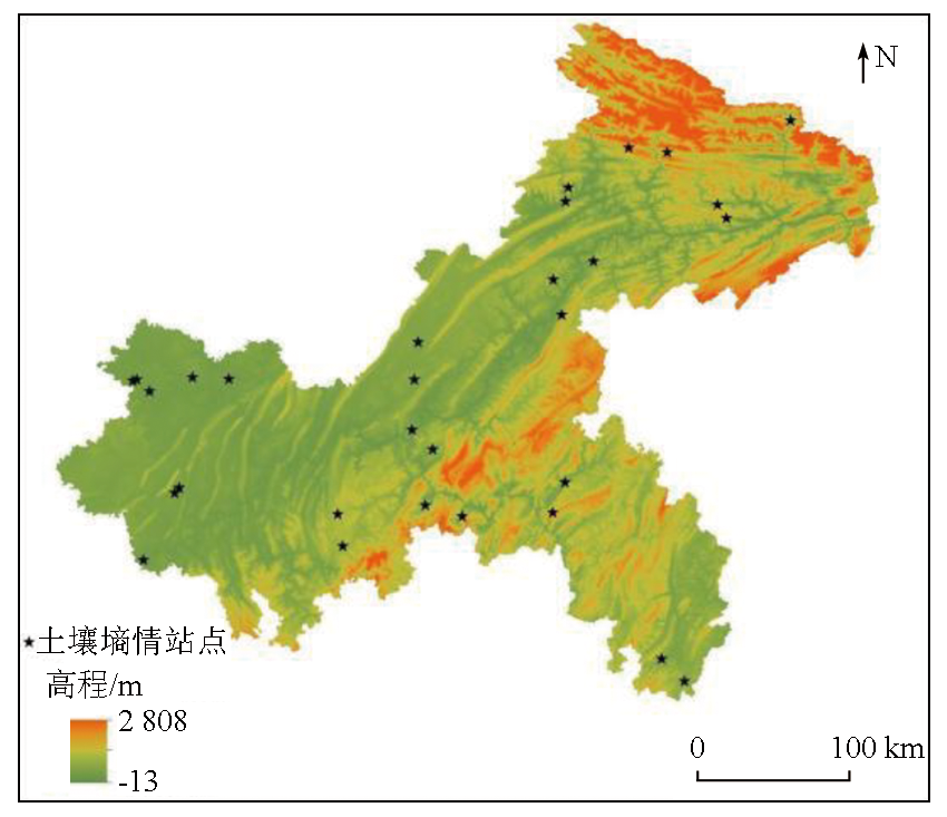
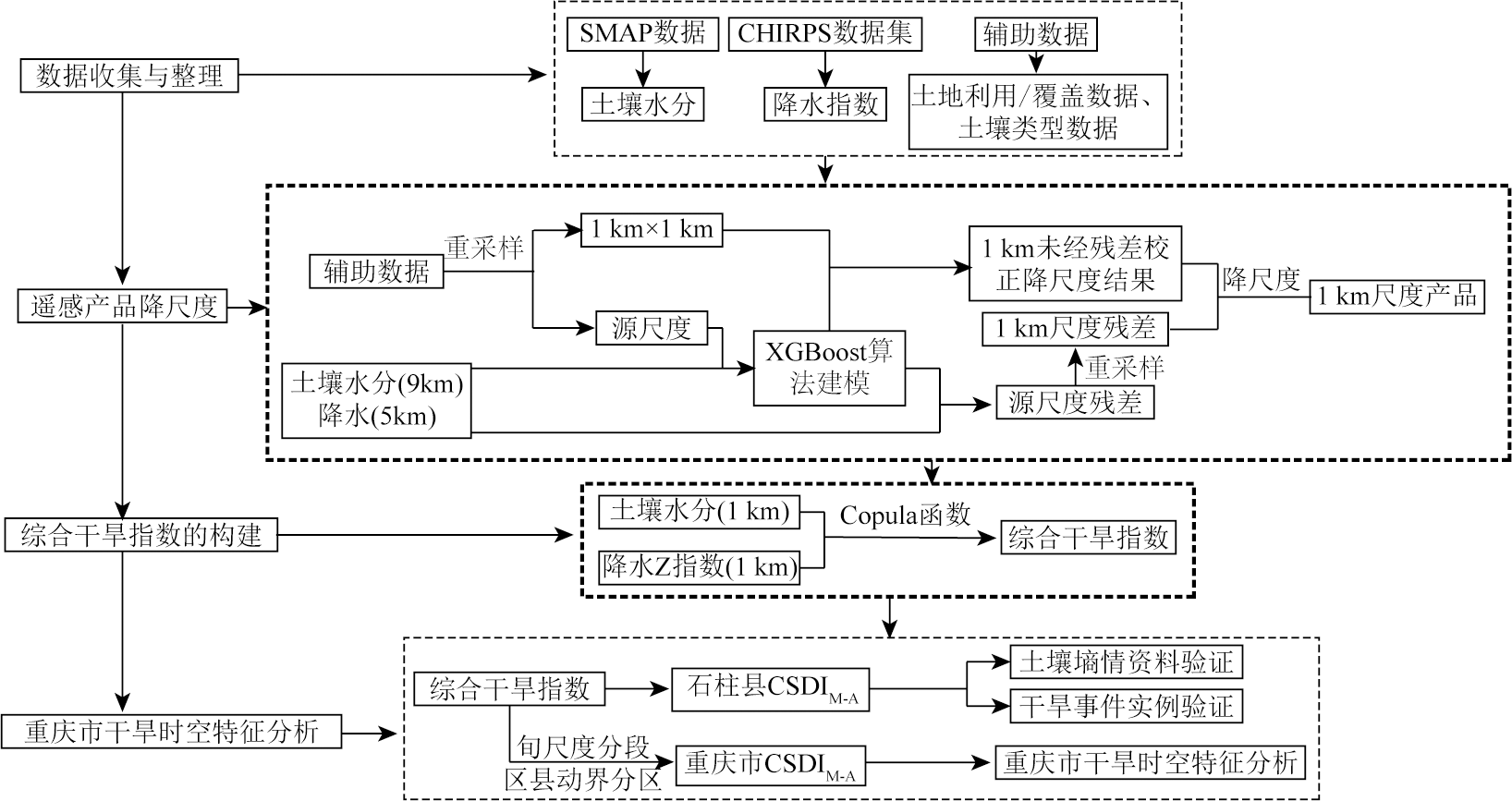
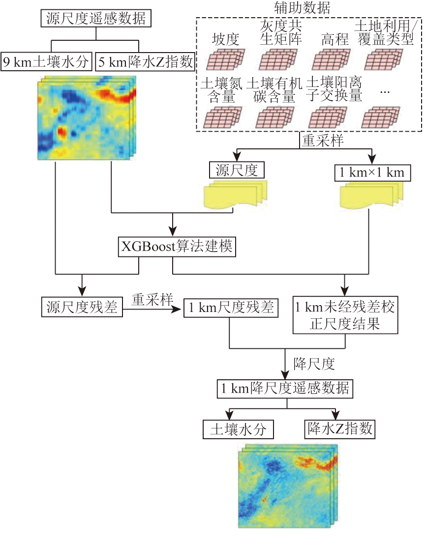
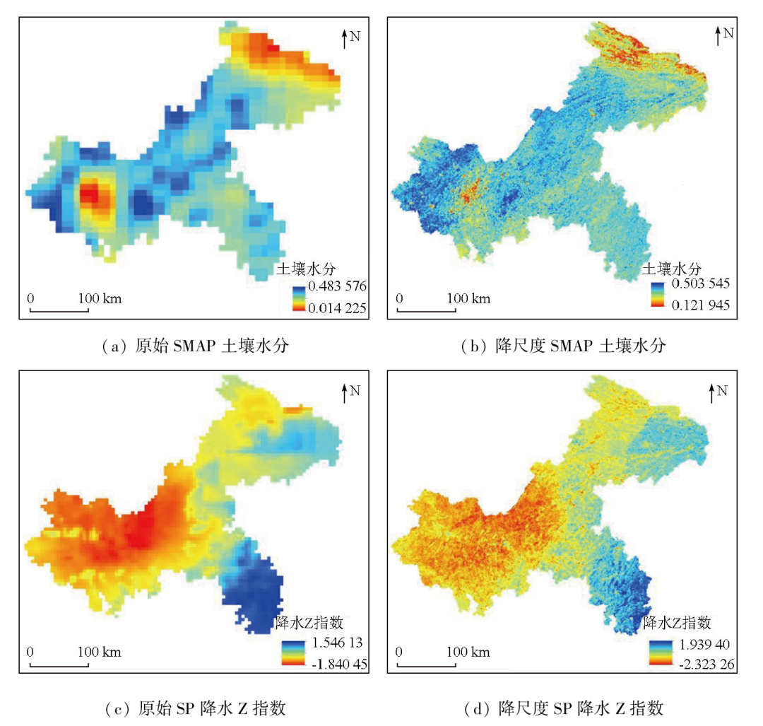
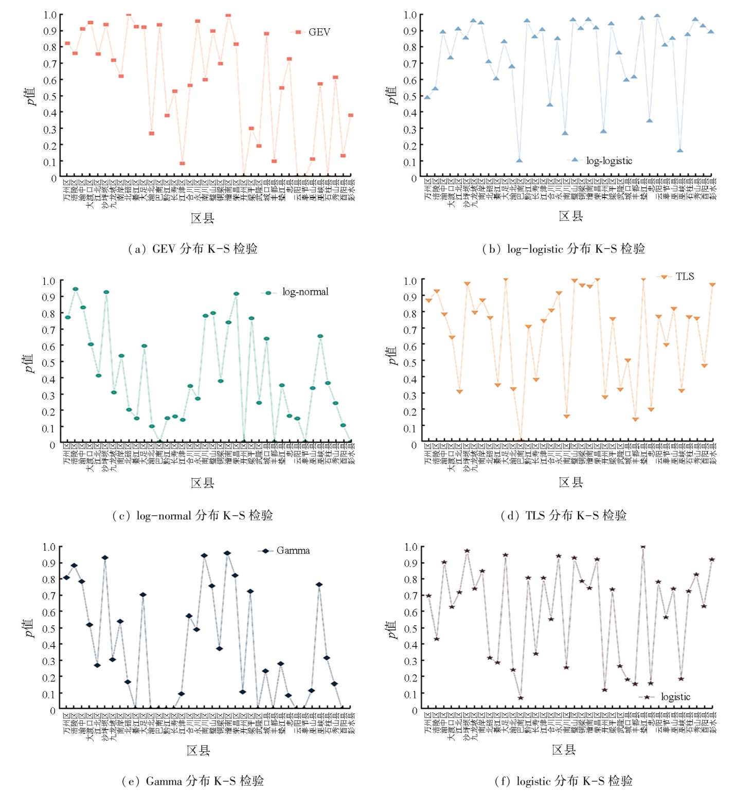
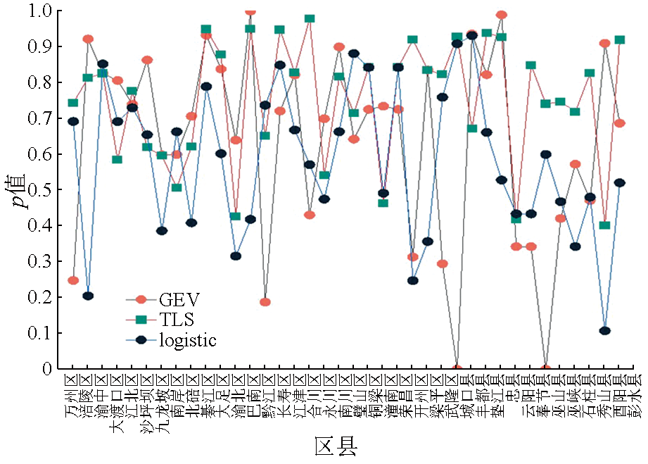
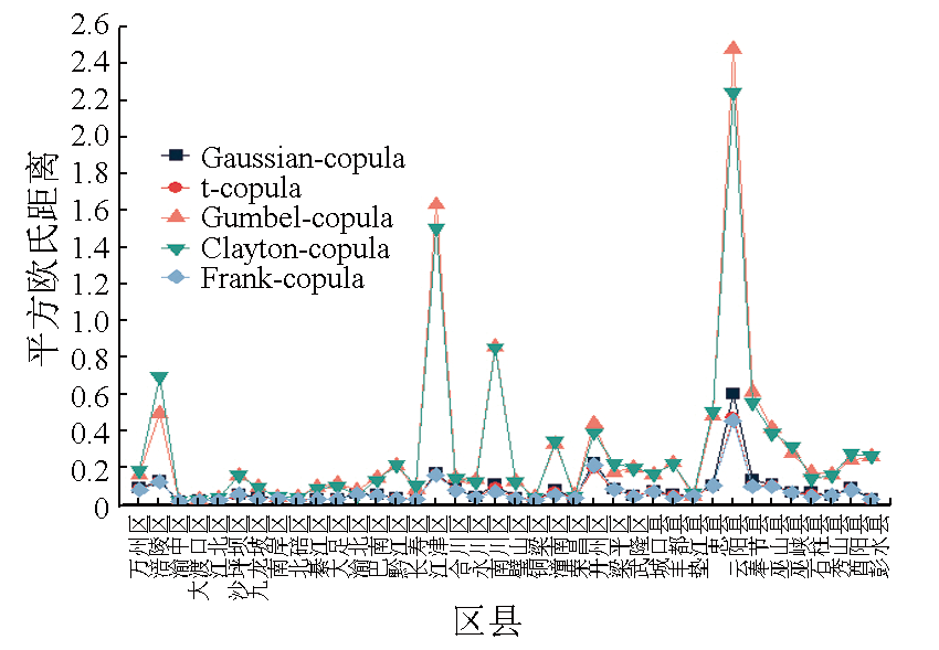
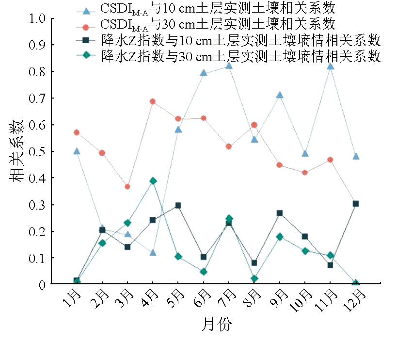
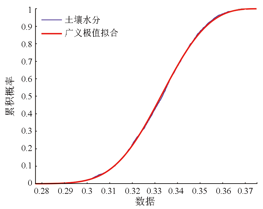
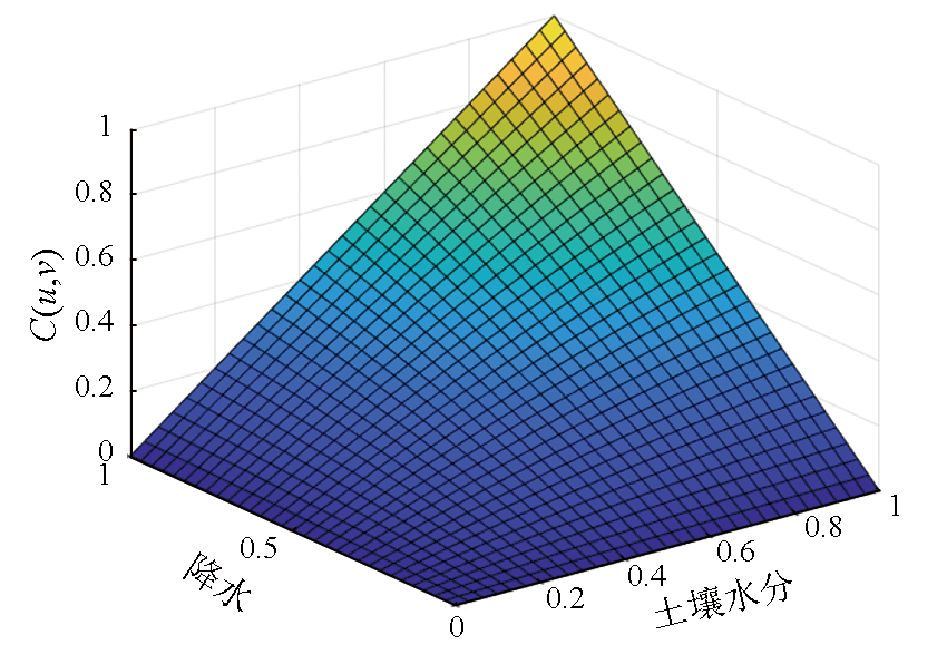
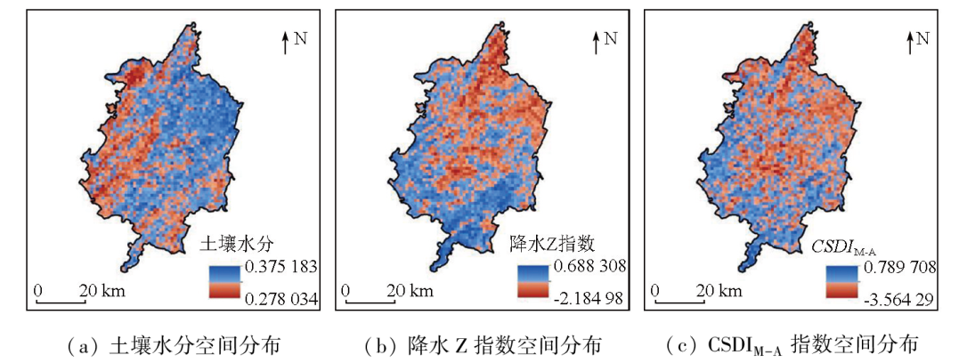
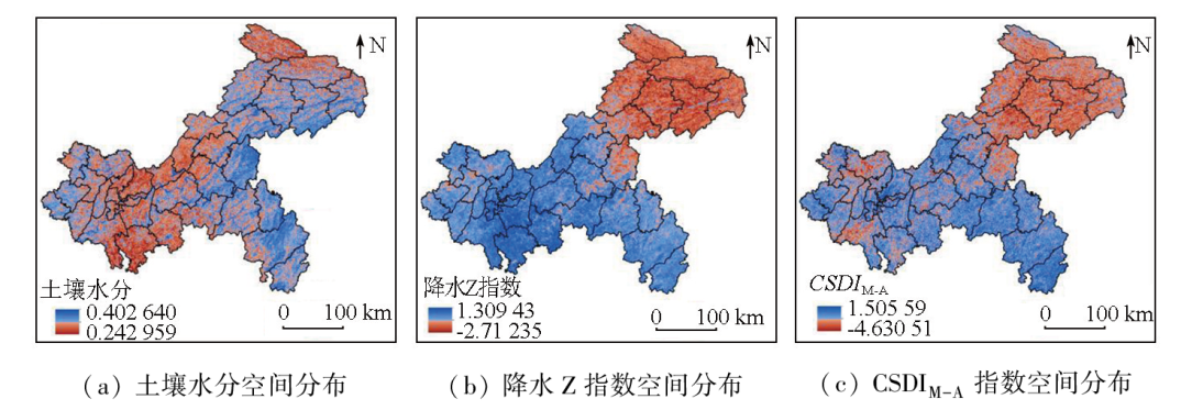
Drought is identified as one type of the most serious natural disasters affecting agricultural production, and developing a comprehensive drought index holds practical significance for the assessment of drought in various districts and counties in Chongqing. By coupling the soil moisture and precipitation Z-index data downscaled using the XGBoost algorithm and using the Copula function, this study developed a gridded comprehensive drought index CSDIM-A on a kilometer scale with the boundaries of various districts and counties of Chongqing as the spatial division criteria and decades of a month as time units. Using this index, this study assessed the spatiotemporal characteristics of drought and performed an experimental demonstration of the index using Chongqing as the study area. The results indicate that the downscaling enhanced the spatial continuity of remote sensing-based products, thus providing support for the subsequent construction of a comprehensive drought index on a kilometer scale. The generalized extreme value distribution and the t location-scale distribution applied to the fitting of the data distributions of soil moisture and precipitation in most districts and counties of Chongqing, respectively, while the Frank-copula function suited for the fitting of the joint distribution of binary variables on a scale of a month decade. As validated based on soil moisture content, CSDIM-A can more effectively reflect drought than the precipitation Z-index, with its spatial distribution in various districts and counties consistent with the actual drought data. This indicates that the CSDIM-A can be used as a reference for drought assessment.
杨辰飞, 吴田军, 王长鹏, 杨丽娟, 骆剑承, 张新. 基于Copula函数的千米尺度综合干旱指数构建与应用——以重庆市为例[J]. 自然资源遥感, 2024, 36(3): 117-127.
YANG Chenfei, WU Tianjun, WANG Changpeng, YANG Lijuan, LUO Jiancheng, ZHANG Xin. Construction and application of a comprehensive drought index based on Copula function on a kilometer scale: A case study of Chongqing, China. Remote Sensing for Natural Resources, 2024, 36(3): 117-127.
Li Y P, Wang J S, Li Y H. Characteristics of a regional meteorological drought event in southwestern China during 2009—2010[J]. Journal of Arid Meteorology, 2015, 33(4):537-545.
[2]
Wilhite D A, Glantz M H. Understanding the drought phenomenon:The role of definitions[J]. Planning for Drought:Toward a Reduction of Societal Vulnerability, 2019:11-27.
Geng H J, Shen B C. Definition and significance of hydrologic droughts[J]. Agricultural Research in the Arid Areas, 1992, 10(4):91-94.
[4]
Jiménez-Donaire M D P, Tarquis A, Giráldez J V. Evaluation of a combined drought indicator and its potential for agricultural drought prediction in southern Spain[J]. Natural Hazards and Earth System Sciences, 2020, 20(1):21-33.
Zhu Y L, Zhang Y. Application of multivariate comprehensive drought index in the Weihe River basin[J]. Journal of Water Resources and Water Engineering, 2022, 33(1):31-38.
[6]
玉院和. 基于多源遥感数据的云南省综合干旱监测模型研究[D]. 昆明: 云南师范大学, 2020.
Yu Y H. Study of comprehensive drought monitoring model of Yunnan Province based on multi-source remote sensing data[D]. Kunming: Yunnan Normal University, 2020.
Liu G M, Xie C J, He T L, et al. Agricultural drought monitoring model constructing based on multi-source data[J]. Journal of Geo-Information Science, 2019, 21(11):1811-1822.
Wu Z Y, Cheng D D, He H, et al. Research progress of composite drought index[J]. Water Resources Protection, 2021, 37(1):36-45.
[9]
Xu L, Chen N, Yang C, et al. A parametric multivariate drought index for drought monitoring and assessment under climate change[J]. Agricultural and Forest Meteorology, 2021, 310:108657.
Li J, Wu X S, Wang Z L, et al. Changes of drought characteristics in future in Pearl River basin describing by a new comprehensive standardized drought index[J]. Journal of Hydraulic Engineering, 2021, 52(4):486-497.
Han D, Wang P X, Zhang Y, et al. Progress of agricultural drought monitoring and forecasting using satellite remote sensing[J]. Smart Agriculture, 2021, 3(2):1-14.
doi: 10.12133/j.smartag.2021.3.2.202104-SA002
Wu Z M, Qiu J X, Liu S X, et al. Advances in agricultural drought monitoring based on soil moisture[J]. Progress in Geography, 2020, 39(10):1758-1769.
doi: 10.18306/dlkxjz.2020.10.014
Du R Q, Zhang Z T, Ju J L, et al. Construction and application of comprehensive drought index based on Bowen ratio and precipitation[J]. Water Saving Irrigation, 2020(8):63-71.
[14]
Sánchez N, González-Zamora A, Piles M, et al. A new soil moisture agricultural drought index (SMADI) integrating MODIS and SMOS products:A case of study over the Iberian peninsula[J]. Remote Sensing, 2016, 8(4):287.
[15]
吴喜之, 王兆军. 非参数统计方法[M]. 北京: 高等教育出版社, 1996.
Wu X Z, Wang Z J. Nonparametric statistical method[M]. Beijing: Higher Education Press, 1996.
Xie Z F, Wang D M, Zhang P, et al. Spatial variation of soil moisture and its environmental influencing factors in A small watershed in the loess alpine region[J]. Journal of Soil and Water Conservation, 2022, 36(4):196-203.
Han L Y, Zhang Q, Ma P L, et al. Spatial characteristics of comprehensive risk of agricultural drought disaster in southwestern China[J]. Journal of Desert Research, 2015, 35(4):1015-1023.
doi: 10.7522/j.issn.1000-694X.2014.00104
Zhu Y, Jin X T, Liu Y, et al. Drought characteristics analysis in China based on self-calibrating Palmer drought severity index in a short time scale[J]. Water Resources Protection, 2022, 38(4):124-130.
Jiang X W, Bai J J, Liu X F. Research progress and prospect of integrated drought monitoring based on multi-source information[J]. Advances in Earth Science, 2019, 34(3):275-287.
doi: 10.11867/j.issn.1001-8166.2019.03.0275
 2024, Vol. 36
  ), 吴田军2(