Deep learning-based remote sensing interpretation and its reliability verification for hydroxyl alteration information in the East Qinling Mountains
LI Chunyi1,2(), ZHAO Pengxiang1,2,3, DING Laizhong3(), WANG Wenjie3, GAO Yantao3, MAI Zhiyao3, GUO Yaxing1,2
1. School of Surveying and Land Information Engineering, Henan Polytechnic University, Jiaozuo 454003, China 2. Key Laboratory of Mine Spatio-Temporal Information and Ecological Restoration, MNR, Jiaozuo 454003, China 3. Mineral Resources Exploration Center of Henan Geological Bureau, Zhengzhou 450012, China
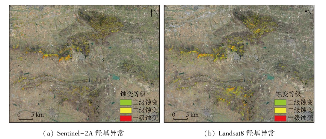
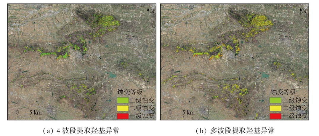
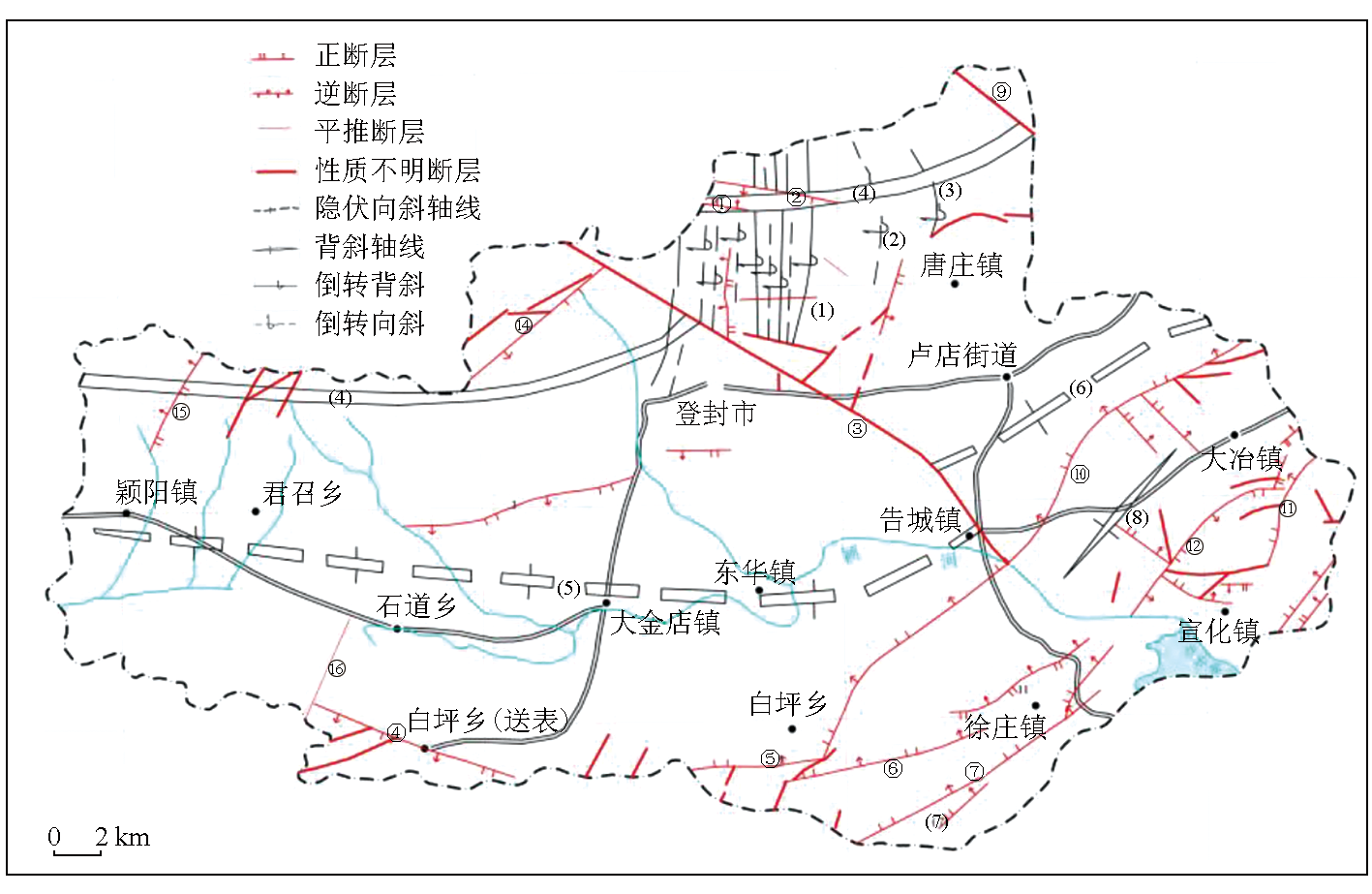
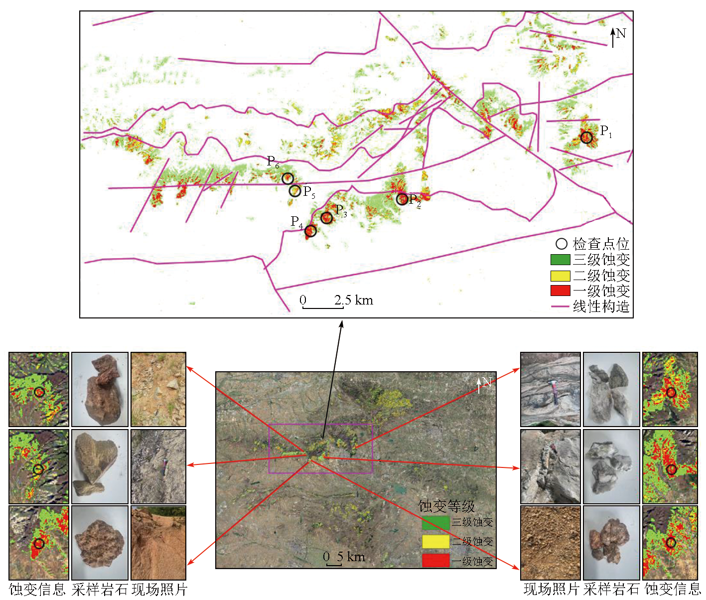
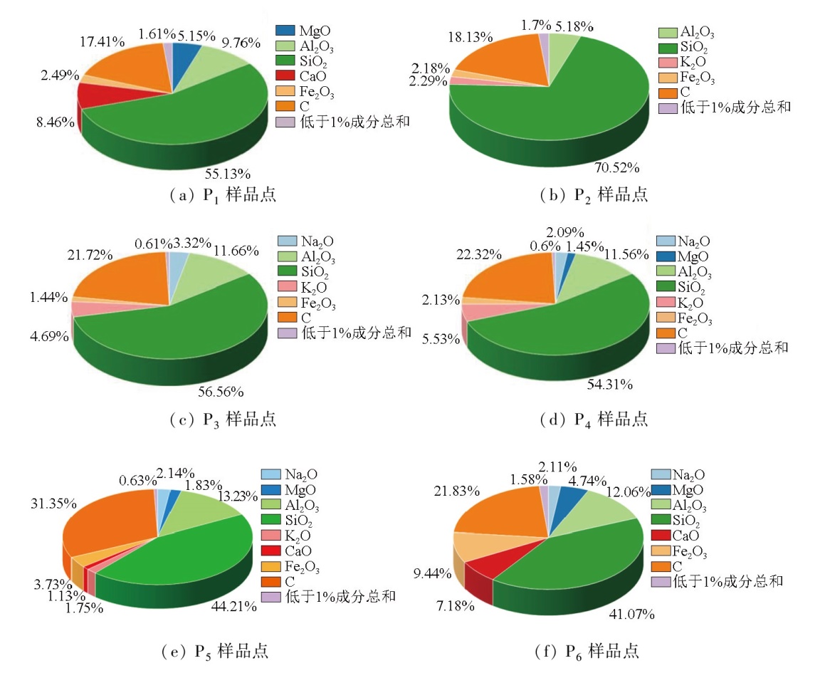
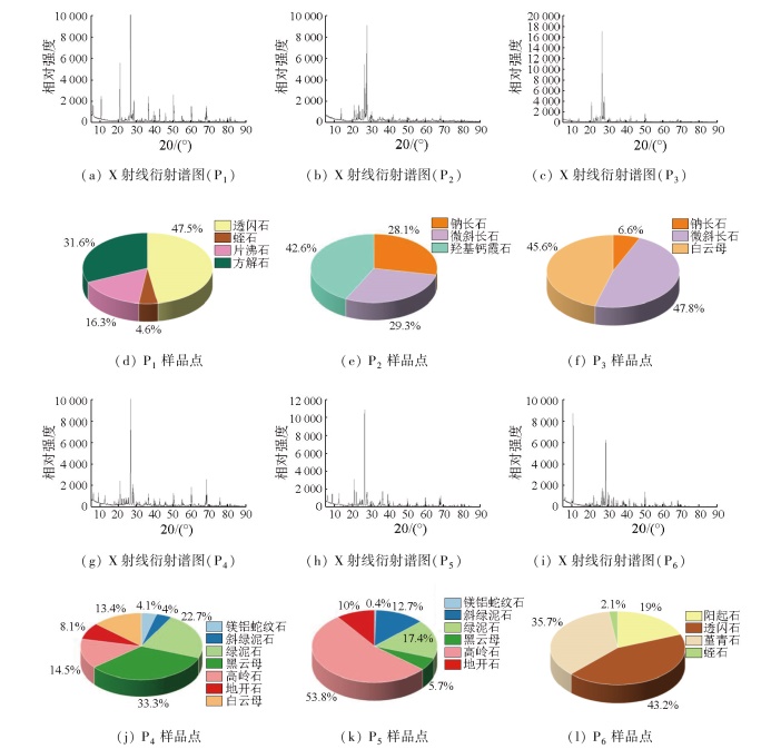
The East Qinling Mountains, located in the eastern Qinling orogen between the North China and Yangtze plates, boast the largest Mo-Au-W polymetallic metallogenic belt in China. Given that alteration played a key role in the mineralization process, its information extraction and distribution characteristics can provide critical insights for analyzing the mineralization mechanisms. To explore a more efficient method for extracting alteration information, this study investigated Dengfeng City in the East Qinling Mountains using data from the Sentinel-2A and Landsat-8 sensors. Data processing and analysis were conducted based on the Google Earth Engine (GEE) platform, and deep learning was applied to the extraction of alteration information. To improve the extraction efficiency, the information about vegetation, water bodies, and buildings was extracted first using the normalized difference vegetation index (NDVI), modified normalized difference water index (MNDWI), and normalized difference built-up index (NDBI), respectively. Subsequently, the interference information was masked by generating binary images using the threshold segmentation method. In combination with the spectral curves of typical hydroxyl minerals, the bands used to extract hydroxyl alteration information were determined. Then, the initial alteration information was extracted using the principal component analysis (PCA) method, and the pixels that overlapped spatially and exhibited concentrated information and high alteration levels were selected as labels to train the deep learning model. The potential information of remote sensing images was further extracted using the convolutional neural network (CNN) model that integrated multi-band data. Finally, in combination with the linear structure maps and mineralization anomalies of the target area, rock and soil samples were collected from the corresponding locations, and their main components were determined using X-ray fluorescence spectroscopy (XRF) and X-ray diffraction (XRD) analysis. In this manner, the reliability of the alteration information extracted was verified. The results indicate that compared to the PCA method alone, the CNN model can extract more comprehensive and clearer hydroxyl alteration information that was more easily graded. The samples collected at the field sampling points all contained minerals with hydroxyl alteration, such as muscovite, biotite, and chlorite. The laboratory XRF and XRD analysis results were consistent with the hydroxyl alteration information extracted using the CNN model. This verifies the reliability and efficiency of the interpretations of hydroxyl alteration information extracted using the deep learning-based CNN model. The results of this study can provide a theoretical and technical basis for remote sensing prospecting in the East Qinling Mountains.
李春意, 赵鹏翔, 丁来中, 王文杰, 高彦涛, 买志瑶, 郭亚星. 基于深度学习的东秦岭羟基蚀变信息遥感解译及可靠性检验[J]. 自然资源遥感, 2025, 37(6): 228-240.
LI Chunyi, ZHAO Pengxiang, DING Laizhong, WANG Wenjie, GAO Yantao, MAI Zhiyao, GUO Yaxing. Deep learning-based remote sensing interpretation and its reliability verification for hydroxyl alteration information in the East Qinling Mountains. Remote Sensing for Natural Resources, 2025, 37(6): 228-240.
Zhao Z L, Wang P, Jing L H, et al. Extraction method of iron mi-neralized alteration information in vegetation covered areas based on remote sensing ASTER data[J]. Metal Mine, 2016(10):109-115.
[2]
Tang S L, Cao J N. Deposit location identification based on feature decomposition of high-resolution remote sensing images[J]. IEEE Access, 2020,9:15239-15251.
Cui S C, Zhou K F, Ding R F. Extraction of plant abnormal information in mining area based on hyperspectral[J]. Spectroscopy and Spectral Analysis, 2019, 39(1):241-249.
Chu Z Y, Wen D G, Lyu Q, et al. Construction and application of remote sensing ore-prospecting model for diamonds in Mengyin area of Shandong,China[J]. Journal of Earth Sciences and Environment, 2024, 46(2):240-251.
Zhang Y F, Li L J, Feng C. The application of ASTER data to bauxite deposit pre-survey in northern China:A case study of Mia-nchi area,western Henan[J]. Remote Sensing for Land and Resources, 2012, 24(1):48-52.doi:10.6046/gtzyyg.2012.01.09.
[6]
Zhang G, Zhao Z F, Zhang X L, et al. Comprehensive Multi-Source remote sensing data integration for enhanced mineralization alteration extraction and geological structure interpretation in the Lala region of Sichuan Province[J]. Ore Geology Reviews, 2024,168:106032.
[7]
Wang Z Y, Zuo R G, Dong Y N. Mapping of Himalaya leucogra-nites based on ASTER and sentinel-2A datasets using a hybrid method of metric learning and random forest[J]. IEEE Journal of Selected Topics in Applied Earth Observations and Remote Sen-sing, 2020,13:1925-1936.
Zhao Z H, Yan S. Some issues relevant to rare metal metallogeny of granitic pegmatites[J]. Geotectonica et Metallogenia, 2023, 47(1):1-41.
[9]
Shirmard H, Farahbakhsh E, Müller R D, et al. A review of machine learning in processing remote sensing data for mineral exploration[J]. Remote Sensing of Environment, 2022,268:112750.
[10]
Chen Q, Xia J S, Zhao Z F, et al. Interpretation of hydrothermal alteration and structural framework of the Huize Pb-Zn deposit,SW China,using Sentinel-2,ASTER,and Gaofen-5 satellite data:Implications for Pb-Zn exploration[J]. Ore Geology Reviews, 2022,150:105154.
Lian C Q, Yao F J, Yang J M, et al. The extraction of alteration information with remote sensing image of semi-exposed area:A case study of the Maqu area in Gansu[J]. Geoscience, 2019, 33(5):1079-1085.
[12]
Crosta A P, Moore J.M. Enhancement of Landsat thematic mapper imagery for residual soil mapping in SW minas gerais state,Brazil:A prospecting case history in greenstone belt terrain[J]. the Se-venth Thematic Conference on Remote sensing for Exploration Geo-logy,Calgary,Alberta,Canada, 1989,1173-1187.
[13]
Adiri Z, Lhissou R, El Harti A, et al. Recent advances in the use of public domain satellite imagery for mineral exploration:A review of Landsat-8 and Sentinel-2 applications[J]. Ore Geology Reviews, 2020,117:103332.
[14]
Vural A, Akpinar ⅰ, Sipahi F. Mineralogical and chemical characteristics of clay areas,gümüşhane region (NE Turkey),and their detection using the Crósta technique with Landsat7 and 8 images[J]. Natural Resources Research, 2021, 30(6):3955-3985.
doi: 10.1007/s11053-021-09912-7
[15]
Pak U S, Pak C U. Detection of hydrothermal alteration zones using Landsat 8 OLI image:A case study of gold prospecting in Nyongwon area,DPR Korea[J]. Journal of the Indian Society of Remote Sensing, 2021, 49(9):2249-2259.
doi: 10.1007/s12524-021-01385-8
Zhao H T, Wang P. Extraction of iron stained information and ore-prospecting prediction of medium-high resolution remote sensing data[J]. Remote Sensing Information, 2017, 32(6):96-102.
[17]
Chen L, Sui X X, Liu R Y, et al. Mapping alteration minerals using ZY-1 02D hyperspectral remote sensing data in coalbed methane enrichment areas[J]. Remote Sensing, 2023, 15(14):3590.
doi: 10.3390/rs15143590
Lian C Q, Yao F J, Feng Z M, et al. Mineral resources prospecting by synthetic application of multi-source data in the shanyangba area,Gansu,China[J]. Geoscience, 2022, 36(6):1605-1612.
Xiao Z, Luo B, Liu Y M. Research on prospecting of ductile shear zone in mining area based on deep learning[J]. World Nonferrous Metals, 2019(21):46-47.
[20]
Agrawal N, Govil H. A deep residual convolutional neural network for mineral classification[J]. Advances in Space Research, 2023, 71(8):3186-3202.
doi: 10.1016/j.asr.2022.12.028
[21]
Wang Z Y, Zuo R G. An evaluation of convolutional neural networks for lithological mapping based on hyperspectral images[J]. IEEE Journal of Selected Topics in Applied Earth Observations and Remote Sensing, 2024,17:6414-6425.
Jia L L, Zhu S B, Wang J R, et al. Prediction of prospecting targets based on semantic segmentation with deep learning:A case study of the Yangjiang-Maoming area in Guangdong Province[J]. Geology and Exploration, 2023, 59(5):1093-1102.
Li X P, Du W T, Cai T G, et al. Extraction of geothermal information from multi-source remote sensing data in the Luoning Basin[J]. Geology and Exploration, 2024, 60(3):552-562.
Han Y H, Wang C Z, Wu Z J, et al. Remote sensing geological interpretation,alteration information extraction,and mineral prospecting prediction in the Chaihulanzi Gold Field,Chifeng,Inner Mongolia[J]. Geoscience, 2024, 38(4):1076-1091.
Yi M, Ye F W, Zhang C, et al. Identification of alteration minerals based on deep learning:A case study of Baiyanghe Uranium Depo-sit,Xinjiang[J]. Uranium Geology, 2021, 37(4):673-682.
 2025, Vol. 37
  ), 赵鹏翔1,2,3, 丁来中3(