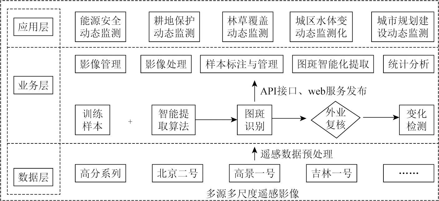
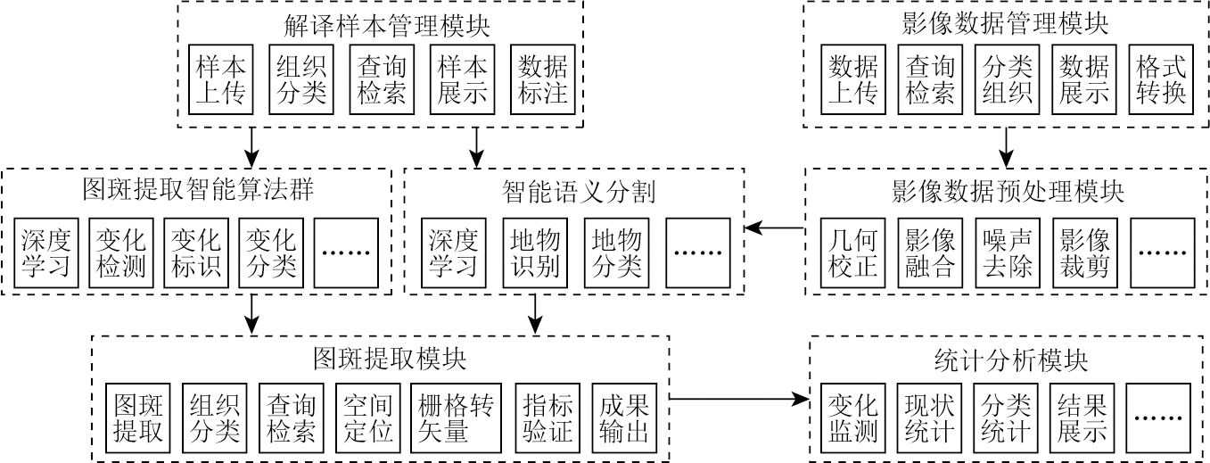
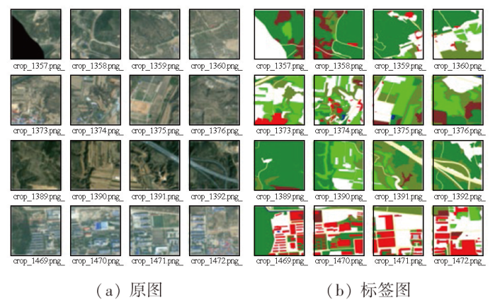
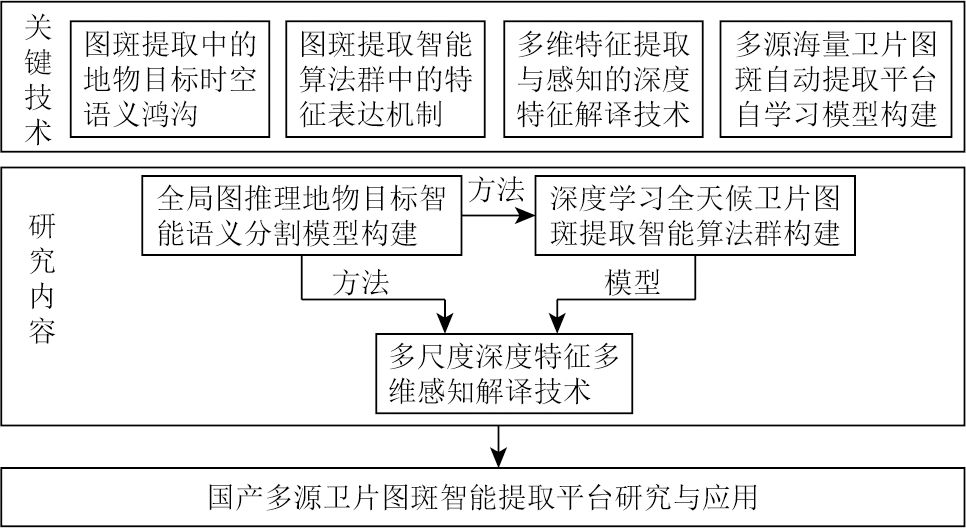
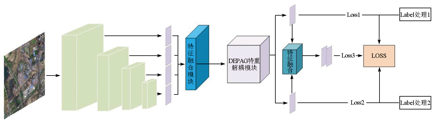
This study designed a one-stop platform for automatically extracting patches from multisource domestic satellite images based on a deep learning framework. The platform focuses primarily on critical techniques including semantic segmentation of ground objects, swarm intelligence algorithms for patch extraction, and deep feature interpretation. To address challenges in remote sensing image interpretation, such as significant color differences, vast data volumes of single images, diverse multi-channel image representations, and considerable differences in the sizes of remote sensing targets, the platform incorporates intelligent semantic segmentation and swarm intelligence algorithms for automatic patch extraction into the framework. It offers a range of customizable general and specialized models while supporting the self-training of models. With functions including large-scale data management, data annotation, model training, model testing, patch extraction, and application analysis, the platform has been successfully applied to the intelligent semantic segmentation and patch extraction of ground objects like buildings, vegetation, farmland, industrial zones, and water bodies in Taiyuan City, Shanxi Province based on multisource domestic satellite images.
庞敏. 国产多源卫片图斑智能提取平台研究与应用[J]. 自然资源遥感, 2025, 37(2): 148-154.
PANG Min. An intelligent platform for extracting patches from multisource domestic satellite images and its application. Remote Sensing for Natural Resources, 2025, 37(2): 148-154.
Liu D S, Liao T K, Sun H Y, et al. Research progress and development direction of Chinese remote sensing software:Taking PIE as an example[J]. Journal of Image and Graphics, 2021, 26(5):1169-1178.
Xu P Y, Xie C Y, Zou J J. Automatic interpretation of high resolution remote sensing images of building based on U-net[J]. Land & Resources Herald, 2023, 20(2):66-71.
Guo H L, Niu Z R, He X H, et al. Remote sensing image semantic segmentation based on multi-scale feature fusion network[J]. Computer Applications and Software, 2023, 40(11):248-253.
[4]
Chen L C, Zhu Y, Papandreou G, et al. Encoder-decoder with atrous separable convolution for semantic image segmentation[C]// Computer Vision - ECCV 2018:15th European Conference,Munich,Germany,September 8-14,2018,Proceedings,Part VII.ACM, 2018:833-851.
[5]
Jiao L, Liang M, Chen H, et al. Deep fully convolutional network-based spatial distribution prediction for hyperspectral image classification[J]. IEEE Transactions on Geoscience and Remote Sen-sing, 2017, 55(10):5585-5599.
Cui B G, Wu J, Li X H, et al. Combination of deep learning and vegetation index for coastal wetland mapping using GF-2 remote sensing images[J]. National Remote Sensing Bulletin, 2023, 27(6):1376-1386.
[7]
李笑迎. 高分辨率遥感图像语义分割网络模型研究[D]. 秦皇岛: 燕山大学, 2022.
Li X Y. Research on semantic segmentation network model of high resolution remote sensing image[D]. Qinhuangdao: Yanshan University, 2022.
Liu H W, Chen F L, Liao Y A. Remote sensing dynamic monitoring and driving factor analysis for the Beijing section of Ming Great Wall[J]. Remote Sensing for Natural Resources, 2023, 35(4):255-263.doi:10.6046/zrzyyg.2022354.
Cheng T, Wu Y, Zheng X Y, et al. A massive sample data acquisition method for intelligent classification of remote sensing images[J]. Bulletin of Surveying and Mapping, 2019(10):56-60.
doi: 10.13474/j.cnki.11-2246.2019.0318
[10]
Zhu X X, Tuia D, Mou L, et al. Deep learning in remote sensing:A comprehensive review and list of resources[J]. IEEE Geoscience and Remote Sensing Magazine, 2017, 5(4):8-36.
[11]
Li S, Song W, Fang L, et al. Deep learning for hyperspectral image classification:An overview[J]. IEEE Transactions on Geoscience and Remote Sensing, 2019, 57(9):6690-6709.
[12]
Deng L T, Zhao Y R. Deep learning-based semantic feature extraction: A literature review and future directions[J]. ZTE Communications, 2023, 21(2): 11-17.
Zhang J, Gao Y. Application of deep learning remote sensing image interpretation technology in cultivated land protection[J]. Bulletin of Surveying and Mapping, 2023(8):142-145.
doi: 10.13474/j.cnki.11-2246.2023.0247
Zhao L H, Yuan X P, Gan S, et al. An information extraction model of roads from high-resolution remote sensing images based on improved Deeplabv3+[J]. Remote Sensing for Natural Resources, 2023, 35(1):107-114.doi: 10.6046/zrzyyg.2021460.
Feng L, Lu H, Geng S S, et al. Remote sensing image semantic segmentation algorithm based on improved Deeplabv3+[J]. Journal of Ningxia Normal University, 2023, 44(10):65-74.
Dai Y D, Yao J G, Li Y, et al. Research on autonomous navigation algorithm for transmission line UAV inspection[J]. Journal of Chongqing University of Technology (Natural Science), 2023, 37(11):221-228.
 2025, Vol. 37
  )
)