Please wait a minute...
 
自然资源遥感  2023, Vol. 35 Issue (3): 43-52    DOI: 10.6046/zrzyyg.2022398
  海岸带空间资源及生态健康遥感监测专栏 本期目录 | 过刊浏览 | 高级检索 |
改进遥感生态指数的典型海岸带城市生态环境质量评价——以湛江市为例
王静1,2(), 王佳1,2, 徐江琪1,2, 黄邵东1,2, 刘东云3()
1.北京林业大学精准林业北京市重点实验室,北京 100091
2.北京林业大学林学院,北京 100091
3.北京林业大学园林学院,北京 100091
Exploring ecological environment quality of typical coastal cities based on an improved remote sensing ecological index: A case study of Zhanjiang City
WANG Jing1,2(), WANG Jia1,2, XU Jiangqi1,2, HUANG Shaodong1,2, LIU Dongyun3()
1. Beijing Key Laboratory of Precision Forestry, Beijing Forestry University,Beijing 100091,China
2. College of Forestry, Beijing Forestry University,Beijing 100091,China
3. School of Landscape Architecture, Beijing Forestry University,Beijing 100091,China
全文: PDF(3935 KB)   HTML  
输出: BibTeX | EndNote (RIS)      
摘要 

随着湛江市城镇化的发展,湛江市生态用地面积减少,生态环境恶化。因此,快速、全面及准确地定量监测湛江市生态环境质量变化具有重要意义。选用2000年、2005年、2009年、2015年、2020年Landsat系列卫星影像,选取绿度、湿度、干度、热度、土地利用与人口分布6项指标,构建改进遥感生态指数(improved remote sensing ecological index,IRSEI),定量分析湛江市2000—2020年间生态环境质量变化。研究结果表明: 2000年、2005年、2009年、2015年与2020年IRSEI指数均值分别为0.18,0.18,0.35,0.42和0.38,呈先升后降的变化趋势; 对2000—2020年间IRSEI进行差值处理,研究区生态环境变化“明显变好”、“轻度变好”、“基本不变”、“轻度变差”、“明显变差”的面积占比分别为78.95%,8.70%,8.01%,1.35%和2.99%,以“明显变好”为主; IRSEI指数可以较好地反映出2000—2020年间海岸带城区环境较差的现象,具体表现为海岸带区域的建筑用地IRSEI指数较低,研究结果将为湛江市生态环境保护提供理论基础和科学依据。

服务
把本文推荐给朋友
加入引用管理器
E-mail Alert
RSS
作者相关文章
王静
王佳
徐江琪
黄邵东
刘东云
关键词 生态环境质量海岸带改进遥感生态指数    
Abstract

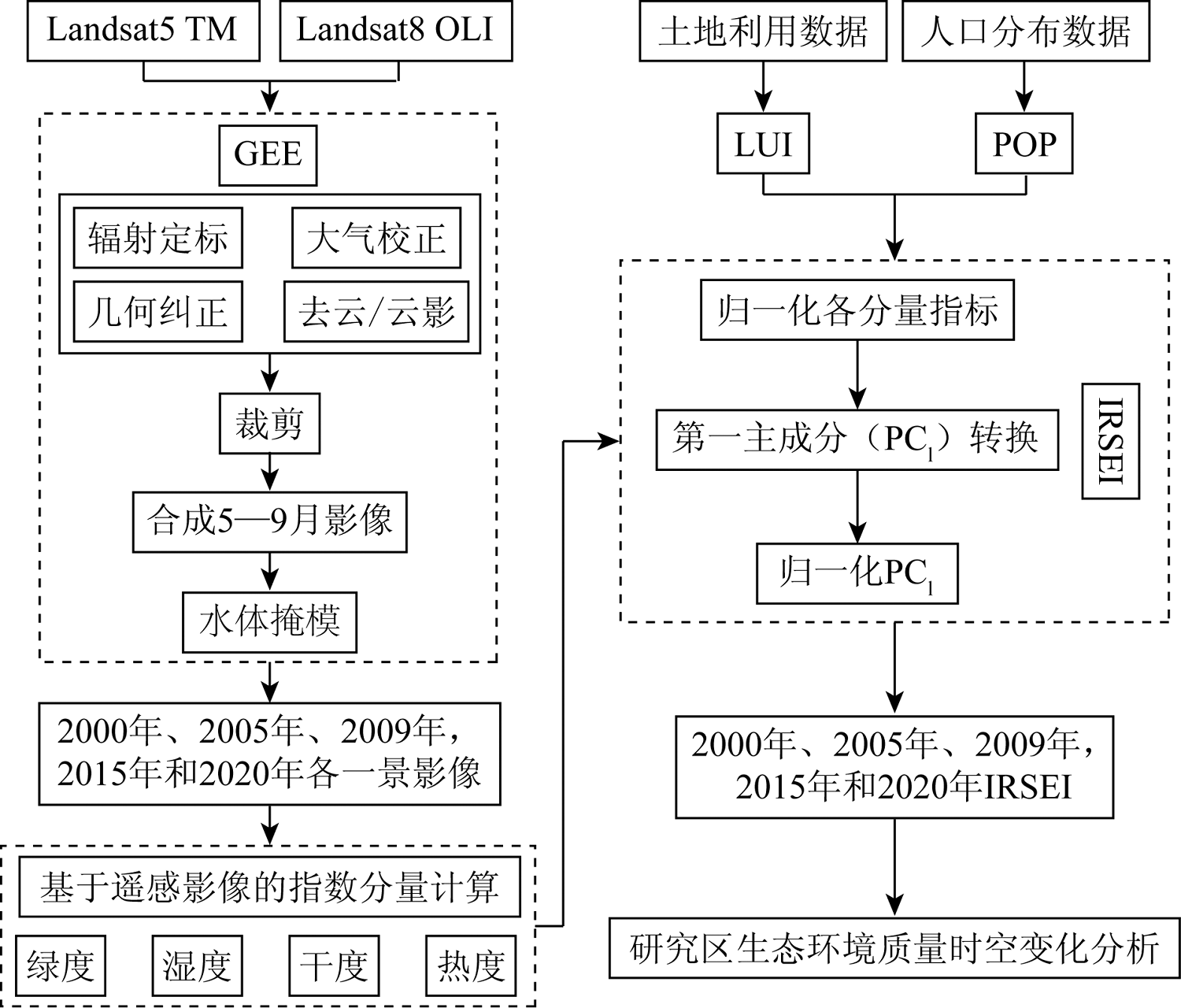
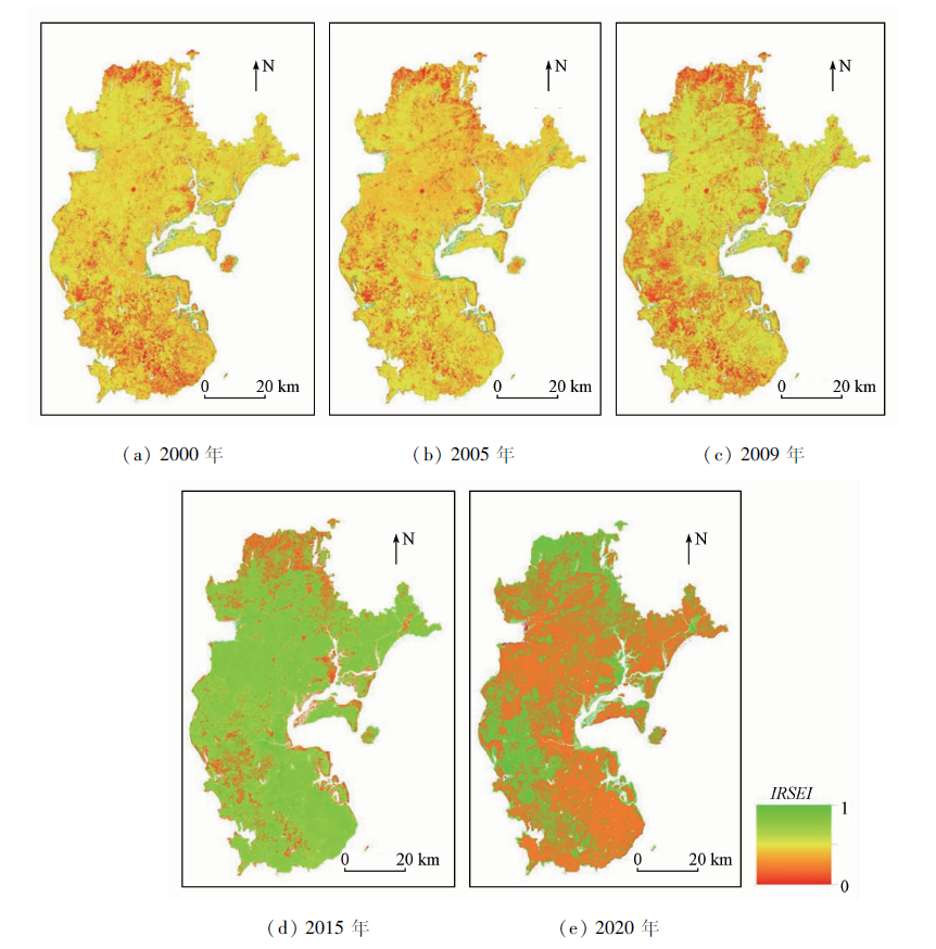
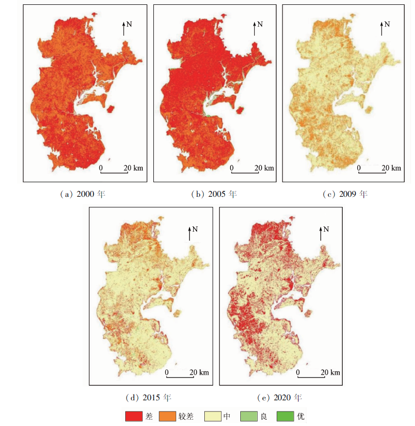
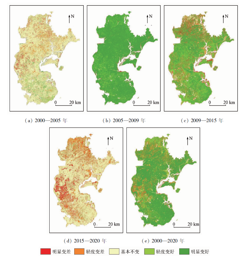
Urbanization has decreased the area of ecological land and deteriorated ecological environment in Zhanjiang City. Therefore, it is significant to quickly, comprehensively, and accurately monitor the changes the ecological environment quality in this city. Based on the Landsat images in 2000, 2005, 2009, 2015, and 2020, this study constructed the improved remote sensing ecological index (IRSEI) using six indicators, namely greenness (NDVI), humidity (WET), dryness (NDBSI), heatiness (LST), land use (LUI), and population distribution (POP). Using IRSEI, this study quantitatively analyzed the changes in the ecological environment quality in Zhanjiang during 2000—2020. The results are as follows: ① The mean IRSEI values of 2000, 2005, 2009, 2015, and 2020 are 0.18, 0.18, 0.35, 0.42, and 0.38, respectively, showing a first increasing and then decreasing trend. ② According to the difference processing on IRSEIs during 2000—2020, the proportions of ecological environment areas with significant improvement (dominant), improvement, no change, deterioration, and significant deterioration in the study area are 78.95%, 8.70%, 8.01%, 1.35%, and 2.99%, respectively. ③ The IRSEI can effectively reflect the poor urban environment along the coastal zone during 2000—2020, specifically manifested as a low IRSEI value of building land along the coastal zone. The results of this study can provide a theoretical and scientific basis for Zhanjiang’s ecological environment protection.

Key wordsecological environment quality    coastal zone    improved remote sensing ecological index
收稿日期: 2022-10-18      出版日期: 2023-09-19
ZTFLH:  TP79  
基金资助:国家自然科学基金项目“融合多源数据的京津冀地区植被NPP对气候变化和人类活动的响应与多情景模拟”(42171329);“基于夜间灯光遥感数据的京津冀地区人口PM2.5暴露时空分异及风险评价”(42071342)
通讯作者: 刘东云(1976-),男,博士,副教授,主要从事生态规划设计与可持续环境技术研究。Email: 987557055@qq.com
作者简介: 王 静(1998-),女,硕士研究生,主要从事遥感大数据在城市生态环境监测中的应用研究。Email: wj15023631023@163.com
引用本文:   
王静, 王佳, 徐江琪, 黄邵东, 刘东云. 改进遥感生态指数的典型海岸带城市生态环境质量评价——以湛江市为例[J]. 自然资源遥感, 2023, 35(3): 43-52.
WANG Jing, WANG Jia, XU Jiangqi, HUANG Shaodong, LIU Dongyun. Exploring ecological environment quality of typical coastal cities based on an improved remote sensing ecological index: A case study of Zhanjiang City. Remote Sensing for Natural Resources, 2023, 35(3): 43-52.
链接本文:  
https://www.gtzyyg.com/CN/10.6046/zrzyyg.2022398      或      https://www.gtzyyg.com/CN/Y2023/V35/I3/43
Fig.1  研究区地理位置
数据类型 空间分辨率/ m 数据来源
Landsat5 SR 30 GEE
Landsat8 SR 30 GEE
土地利用类型 30 武汉大学黄昕团队研究的产品数据(earth system science data)[20]
人口分布 100 南安普大学Worldpop研究小组的产品数据(open data for spatial demography)[21]
行政区矢量边界 30 地理国情监测平台(http://www.dsac.cn)
Tab.1  数据来源
Fig.2  研究技术路线
年份 主成分分量 NDVI WET NDBSI LST LUI POP 特征值 特征值贡献率
2000年 PC1 0.530 0.229 -0.204 -0.777 -0.002 -0.149 0.517 2 0.887
PC2 -0.472 -0.096 0.131 -0.224 0.007 -0.837 0.049 0 0.084
PC3 -0.544 -0.137 -0.729 -0.274 -0.006 0.281 0.010 2 0.017
2005年 PC1 0.495 0.232 -0.225 -0.795 -0.001 -0.136 0.571 6 0.895
PC2 -0.573 -0.109 0.127 -0.297 0.005 -0.745 0.049 1 0.077
PC3 -0.520 -0.118 -0.723 -0.219 -0.006 0.381 0.010 8 0.017
2009年 PC1 0.517 0.241 -0.074 -0.171 -0.580 -0.551 0.551 4 0.868
PC2 0.463 0.130 0.387 0.113 0.298 0.719 0.061 6 0.097
PC3 0.528 0.217 -0.536 -0.255 -0.540 0.173 0.011 0 0.017
2015年 PC1 0.444 0.327 -0.250 -0.790 -0.091 -0.002 0.244 6 0.744
PC2 0.327 -0.214 -0.053 -0.151 -0.906 0.027 0.052 8 0.161
PC3 0.619 -0.398 -0.217 -0.492 0.412 -0.013 0.021 4 0.065
2020年 PC1 0.444 0.310 -0.738 -0.231 -0.330 -0.012 0.241 3 0.753
PC2 0.206 0.170 -0.221 -0.018 0.939 0.001 0.052 5 0.164
PC3 0.516 -0.041 0.291 -0.953 0.046 -0.002 0.021 7 0.068
Tab.2  各年份各指标PCA结果
年份 NDVI WET NDBSI LST LUI POP IRSEI
均值
2000年 0.72 0.75 0.73 0.75 0.53 0.20 0.18
2005年 0.71 0.75 0.73 0.74 0.53 0.21 0.18
2009年 0.74 0.75 0.75 0.74 0.57 0.21 0.35
2015年 0.55 0.57 0.55 0.16 0.42 0.17 0.42
2020年 0.59 0.56 0.54 0.15 0.43 0.17 0.38
均值 0.66 0.68 0.66 0.51 0.50 0.19 0.30
Tab.3  不同年份IRSEI均值及IRSEI与各指标的平均相关度
Fig.3  2000—2020年IRSEI时空分布
等级 2000年 2005年 2009年 2015年 2020年
面积/km2 比例/% 面积/km2 比例/% 面积/km2 比例/% 面积/km2 比例/% 面积/km2 比例/%
差[0,0.2) 6 385.38 48.28 8 659.39 65.48 0.01 0.00 1 043.53 7.89 4 072.28 30.79
较差[0.02,0.35) 6 605.60 49.95 4 326.90 32.72 4 478.66 33.87 2 529.22 19.12 0.00 0.00
中[0.35,0.55) 137.20 1.04 79.37 0.60 8 674.53 65.59 9 495.07 71.80 9 083.81 68.69
良[0.55,0.75) 27.78 0.21 0.03 0.00 37.34 0.28 142.90 1.08 63.43 0.48
优[0.75,1] 69.04 0.52 159.31 1.20 34.46 0.26 14.27 0.11 5.42 0.04
Tab.4  各年份不同等级IRSEI的面积与比例
Fig.4  2000—2020年生态环境质量分级
变化程度 2000—2005年 2005—2009年 2009—2015年 2015—2020年 2000—2020年
面积/km2 比例/% 面积/km2 比例/% 面积/km2 比例/% 面积/km2 比例/% 面积/km2 比例/%
明显变差
[-1,-0.1)
821.62 6.21 167.38 1.27 1 223.97 9.25 1 433.22 10.84 395.50 2.99
轻度变差
[-0.1,0.02)
1 318.17 9.97 2.63 0.02 1 008.76 7.63 2 706.29 20.46 178.73 1.35
基本不变
[0.02,0.05)
9 777.17 73.93 400.89 3.03 1 612.28 12.19 8 453.99 63.92 1 059.36 8.01
轻度变好
[0.05,0.1)
348.94 2.64 879.65 6.65 2 656.56 20.09 70.91 0.54 1 149.94 8.70
明显变好
[0.1,1]
959.11 7.25 11 774.46 89.03 6 723.43 50.84 560.58 4.24 10 441.48 78.95
Tab.5  不同程度生态环境质量变化
Fig.5  2000—2020年湛江市生态环境空间变化
[1] 李加林, 汪海峰, 田鹏. 海岸带开发利用研究进展[J]. 海洋经济, 2022, 12(2):21-31.
Li J L, Wang H F, Tian P. Research progress of coastal zone develo-pment[J]. Marine Economy, 2022, 12(2):21-31.
[2] 许学工, 彭慧芳, 徐勤政. 海岸带快速城市化的土地资源冲突与协调——以山东半岛为例[J]. 北京大学学报(自然科学版), 2006, 42(4):527-533.
Xu X G, Peng H F, Xu Q Z. Land resource conflicts and coordination in fast urbanized coastal zone:A case study of the Shandong Peninsula[J]. Journal of Peking University (Natural Science Edition), 2006, 42(4):527-533.
[3] 陈晔倩, 李杨帆, 祁新华, 等. 基于栖息地风险评价模型的海岸带滩涂湿地风险评价——以闽三角为例[J]. 生态学报, 2018, 38(12):4214-4225.
Chen Y Q, Li Y F, Qi X H, et al. Assessing ecosystem risk in coastal wetland of the South Fujian Golden Delta using a habitat risk assessment model based on the land-use effect on tidal flat wetland[J]. Ecological Journal, 2018, 38 (12):4214-4225.
[4] 环境保护部. HJ 192—2015生态环境状况评价技术规范[S]. 北京: 中国环境科学出版社, 2015.
Ministry of Environmental Protection. HJ 192—2015 Technical specifications for ecological environment assessment[S]. Beijing: China Environmental Science Press, 2015.
[5] 徐涵秋. 城市遥感生态指数的创建及其应用[J]. 生态学报, 2013, 33(24):7853-7862.
Xu H Q. A remote sensing urban ecological index and its application[J]. Acta Ecologica Sinica, 2013, 33(24):7853-7862.
[6] 农兰萍, 王金亮. 基于 RSEI 模型的昆明市生态环境质量动态监测[J]. 生态学杂志, 2020, 39(6):2042-2050.
Nong L P, Wang J L. Dynamic monitoring of ecological environment quality in Kunming based on RSEI model[J]. Chinese Journal of Ecology, 2020, 39(6):2042-2050.
[7] 吴可人, 高祺, 王让会, 等. 基于 RSEI模型的石家庄生态环境质量评价[J]. 地球物理学进展, 2021, 36(3):968-976.
Wu K R, Gao Q, Wang R H, et al. Evaluation of ecological environment quality in Shijiazhuang based on RSEI model[J]. Progress in Geophysics, 2021, 36(3):968-976.
[8] Gao P, Kasimu A, Zhao Y, et al. Evaluation of the temporal and spatial changes of ecological quality in the Hami Oasis based on RSEI[J]. Sustainability, 2020, 12(18):7716.
doi: 10.3390/su12187716
[9] Ji J, Wang S, Zhou Y, et al. Spatiotemporal change and landscape pattern variation of eco-environmental quality in Jing-Jin-Ji urban agglomeration from 2001 to 2015[J]. IEEE Access, 2022, 8:125534-125548.
doi: 10.1109/Access.6287639
[10] 缪鑫辉, 梁勤欧. 基于遥感生态指数的甬江流域生态环境变化分析[J]. 长江流域资源与环境, 2021, 30(2):427-438.
Miao X H, Liang Q O. Analysis of ecological environment changes in Yongjiang River basin based on remote sensing ecological index[J]. Resources and Environment in the Yangtze River Basin, 2021, 30(2):427-438.
[11] 宋美杰, 罗艳云, 段利民. 基于改进遥感生态指数模型的锡林郭勒草原生态环境评价[J]. 干旱区研究, 2019, 36(6):1521-1527.
Song M J, Luo Y Y, Duan L M. Evaluation of ecological environment in the Xilin Gol Steppe based on modified remote sensing eco-logical index model[J]. Arid Zone Research, 2019, 36(6):1521-1527.
[12] 程琳琳, 王振威, 田素锋, 等. 基于改进的遥感生态指数的北京市门头沟区生态环境质量评价[J]. 生态学杂志, 2021, 40(4):1177-1185.
Cheng L L, Wang Z W, Tian S F, et al. Evaluation of eco-environmental quality in Mentougou District of Beijing based on improved remote sensing ecological index[J]. Chinese Journal of Ecology, 2021, 40(4): 1177-1185.
[13] 王杰, 马佳丽, 解斐斐, 等. 干旱地区遥感生态指数的改进——以乌兰布和沙漠为例[J]. 应用生态学报, 2020, 31(11):3795-3804.
doi: 10.13287/j.1001-9332.202011.011
Wang J, Ma J L, Xie F F, et al. Improvement of remote sensing eco-logical index in arid regions:Taking Ulan Buh Desert as an example[J]. Chinese Journal of Applied Ecology, 2020, 31(11):3795-3804.
[14] 蒋超亮, 吴玲, 刘丹, 等. 干旱荒漠区生态环境质量遥感动态监测——以古尔班通古特沙漠为例[J]. 应用生态学报, 2019, 30(3):877-883.
doi: 10.13287/j.1001-9332.201903.008
Jiang C L, Wu L, Liu D, et al. Dynamic monitoring of eco-environmental quality in arid desert area by remote sensing:Taking the Gurbantunggut Desert China as an example[J]. Chinese Journal of Applied Ecology, 2019, 30(3):877-883.
[15] 张伟, 杜培军, 郭山川, 等. 改进型遥感生态指数及干旱区生态环境评价[J]. 遥感学报, 2022, 26(7):1-19.
Zhang W, Du P J, Guo S C, et al. Enhanced remote sensing ecological index and ecological environment evaluation in arid area[J]. National Remote Sensing Bulletin, 2022, 26(7):1-19.
[16] 李洋. 基于多要素的海岛城市生态状况评价[D]. 福州: 福州大学, 2017.
Li Y. Evaluation of island city’s ecological status based on multiple elelments:A case study of Pingtan comprehensive experimentation zone,Fujian Province[D]. Fuzhou: Fuzhou University, 2017.
[17] 付杰, 王萍, 张清, 等. 基于改进遥感生态指数的海南岛生态环境质量动态变化[J]. 农业资源与环境学报, 2021, 38(6):1102-1111.
Fu J, Wang P, Zhang Q, et al. Dynamic monitoring of ecological environment quality of Hainan Island based on improved remote sensing ecological index[J]. Journal of Agricultural Resources and Environment, 2021, 38(6):1102-1111.
[18] 许妍, 曹可, 李冕, 等. 海岸带生态风险评价研究进展[J]. 地球科学进展, 2016, 31(2):137-146.
doi: 10.11867/j.issn.1001-8166.2016.02.0137.
Xu Y, Cao K, Li M, et al. Coastal ecological risk assessment:Its research progress and prospect[J]. Advances in Earth Science, 2016, 31(2):137-146.
[19] 湛江红树林国家级自然保护区[J]. 环境, 2021, 44(10):51.
Zhanjiang mangrove national nature reserve[J]. Environment, 2021, 44(10):51.
[20] Yang J, Huang X. The 30 m annual land cover dataset and its dynamics in China from 1990 to 2019[J]. Earth System Science Data, 2021, 13(8):3907-3925.
doi: 10.5194/essd-13-3907-2021
[21] Xu H, Wang Y, Guan H, et al. Detecting ecological changes with a remote sensing based ecological index(RSEI)produced time series and change vector analysis[J]. Remote Sensing, 2019, 11(20):2345.
doi: 10.3390/rs11202345
[22] 李凤莹, 张饮江, 赵志淼, 等. 基于遥感生态指数的上海南汇东滩海岸带湿地生态格局变化评价[J]. 上海海洋大学学报, 2020, 29(5):746-756.
Li F Y, Zhang Y J, Zhao Z M, et al. Evaluation of ecological pattern change of Nanhui Dongtan wetland in Shanghai based on remote sensing ecological index[J]. Journal of Shanghai Ocean University, 2020, 29(5):746-756.
[23] 农兰萍, 王金亮, 玉院和. 基于改进型遥感生态指数(MRSEI)模型的滇中地区生态环境质量研究[J]. 生态与农村环境学报, 2021, 37(8):972-982.
Nong L P, Wang J L, Yu Y H. Research on ecological environment quality in central Yunnan based on MRSEI model[J]. Journal of Ecology and Rural Environment, 2021, 37(8):972-982.
[24] 王丽春, 焦黎, 来风兵, 等. 基于遥感生态指数的新疆玛纳斯湖湿地生态变化评价[J]. 生态学报, 2019, 39(8):2963-2972.
Wang L C, Jiao L, Lai F B, et al. Evaluation of ecological changes based on a remote sensing ecological index in a Manas Lake wetland,Xinjiang[J]. Acta Ecologica Sinica, 2019, 39(8):2963-2972.
[25] Chander G, Markham B L, Helder D L. Summary of current radiometric calibration coefficients for Landsat MSS,TM,ETM+,and EO-1 ALI sensors[J]. Remote Sensing of Environment, 2009, 113(5):893-903.
doi: 10.1016/j.rse.2009.01.007
[26] Rikimaru A, Roy P S, Miyatake S. Tropical forest cover density mapping[J]. Tropical Ecology, 2002, 43(1):39-47.
[27] 吴传钧, 郭焕成. 中国土地利用[M]. 北京: 科学出版社, 1994:35-36.
Wu C J, Guo H C. Land utilization in China[M]. Beijing: Science Press, 1994:35-36.
[28] 徐勇, 孙晓一, 汤青. 陆地表层人类活动强度:概念、方法及应用[J]. 地理学报, 2015, 70(7):1068-1079.
doi: 10.11821/dlxb201507004
Xu Y, Sun X Y, Tang Q. Human activity intensity of land surface:Concept,method and application in China[J]. Journal of Geography, 2015, 70 (7):1068-1079.
[29] 杭鑫, 罗晓春, 曹云, 等. 基于RSEI模型的生态质量评估及城镇化影响——以南京市为例[J]. 应用生态学报, 2020, 31(1):219-229.
doi: 10.13287/j.1001-9332.202001.030
Hang X, Luo X C, Cao Y, et al. Ecological quality assessment and the impact of urbanization based on RSEI model for Nanjing,Jiangsu Province,China[J]. Chinese Journal of Applied Ecology, 2020, 31(1): 219-229.
[30] 徐涵秋, 邓文慧. MRSEI指数的合理性分析及其与RSEI指数的区别[J]. 遥感技术与应用, 2022, 37(1):1-7.
Xu H Q, Deng W H. Rationality analysis of MRSEI and its difference with RSEI[J]. Remote Sensing Technology and Application, 2022, 37 (1):1-7.
[1] 闫柏琨, 甘甫平, 印萍, 葛晓立, 郭艺, 白娟. 1989—2021年中国大陆海岸带潮滩、海岸线、养殖水体遥感观测[J]. 自然资源遥感, 2023, 35(3): 53-63.
[2] 史姝姝, 窦银银, 陈永强, 匡文慧. 中国海岸带区域城市扩展遥感监测与内部地表覆盖时空分异特征分析[J]. 自然资源遥感, 2022, 34(4): 76-86.
[3] 江娜, 陈超, 韩海丰. 海岸带地类统计模型中DEM空间尺度优选方法[J]. 自然资源遥感, 2022, 34(1): 34-42.
[4] 吴芳, 金鼎坚, 张宗贵, 冀欣阳, 李天祺, 高宇. 基于CZMIL测深技术的海陆一体地形测量初探[J]. 自然资源遥感, 2021, 33(4): 173-180.
[5] 苗苗, 谢小平. 基于GIS和RS的山东日照海岸带1988—2018年间演化分析[J]. 国土资源遥感, 2021, 33(2): 237-247.
[6] 应奎, 李旭东, 程东亚. 岩溶槽谷流域生态环境质量的遥感评定[J]. 国土资源遥感, 2020, 32(3): 173-182.
[7] 韩亚超, 李奇, 张永军, 高子弘, 杨达昌, 陈洁. 机载高光谱仪几何检校方法及其在海岸带航空遥感调查中的示范应用[J]. 国土资源遥感, 2020, 32(1): 60-65.
[8] 金鼎坚, 王建超, 吴芳, 高子弘, 韩亚超, 李奇. 航空遥感技术及其在地质调查中的应用[J]. 国土资源遥感, 2019, 31(4): 1-10.
[9] 张洪敏, 张艳芳, 田茂, 吴春玲. 基于主成分分析的生态变化遥感监测——以宝鸡市城区为例[J]. 国土资源遥感, 2018, 30(1): 203-209.
[10] 詹雅婷, 朱叶飞, 苏一鸣, 崔艳梅. 基于国土资源卫星的盐城海岸带生态环境变化调查[J]. 国土资源遥感, 2017, 29(s1): 160-165.
[11] 刘荣杰, 张杰, 李晓敏, 马毅. ZY-3影像在我国海岸带区域的定位精度评价[J]. 国土资源遥感, 2014, 26(3): 141-145.
[12] 冯永玖, 韩震. 基于遥感和GIS的海岸带水域生态景观格局演变研究——以杭州湾北岸上海市段为例[J]. 国土资源遥感, 2011, 23(1): 123-127.
[13] 李振, 黄海军. 胶州湾海岸带土地利用/覆被变化研究[J]. 国土资源遥感, 2010, 22(4): 71-76.
[14] 吴均平, 毛志华, 陈建裕, 白雁, 陈晓东, 潘德炉. 一种加入空间关系的海岸带遥感图像分类方法[J]. 国土资源遥感, 2006, 18(3): 10-14.
[15] 姜义, 李建芬, 康慧, 钟新宝. 渤海湾西岸近百年来海岸线变迁遥感分析[J]. 国土资源遥感, 2003, 15(4): 54-58.
Viewed
Full text


Abstract

Cited

  Shared   
  Discussed   
京ICP备05055290号-2
版权所有 © 2015 《自然资源遥感》编辑部
地址:北京学院路31号中国国土资源航空物探遥感中心 邮编:100083
电话:010-62060291/62060292 E-mail:zrzyyg@163.com
本系统由北京玛格泰克科技发展有限公司设计开发