Exploring the spatiotemporal evolution of bottomland in Dongting Lake based on multisource remote sensing
YU Shuchen1,2,3,4(), QIU Luo2,3,4,5(), HE Qiuhua1,2,3,4, JIN Xiaoyan1, LI Jiabao1, YU Deqing1,2,3,4
1. Hunan Natural Resources Affairs Center, Changsha 410004, China 2. Hunan Key Laboratory of Remote Sensing Monitoring of Ecological Environment in Dongting Lake Area, Changsha 410007, China 3. Dongting Lake Basin Ecological Protection and Restoration Engineering Technology Innovation Center, Ministry of Natural Resources, Changsha 410004, China 4. Dongting Lake Natural Resource Ecosystem Field Scientific Research Station, Ministry of Natural Resources, Changsha 410007, China 5. School of Computational Sciences and Electronics, Hunan Institute of Engineering, Xiangtan 411104, China
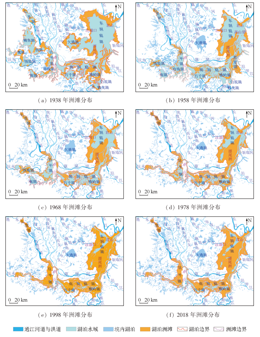
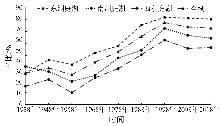
To explore the spatiotemporal evolution of the bottomland in Dongting Lake since the middle stage of the Republic of China, this study examined the historical topographic maps and aerospace remote sensing data concerning the study area for over 10 time periods since the 1930s. Based on remote sensing image interpretation, statistical data analysis, and historical comparison, this study analyzed the temporal variations in the bottomland area of Dongting Lake in various periods to infer the corresponding spatial distributions of the bottomland. The results show that the spatial development of the bottomland in Dongting Lake was primarily characterized by the rapidly advancing delta at the mouth of the east branch of the Ouchi River and Piaowei Islet in East Dongting Lake, the alluvial deposits along the Caowei and Songzhu rivers in the north of South Dongting Lake, and the “Jiangnan Grassland” landscape formed by the bottom uplift of Qili and Muping lakes. The bottomland area in Dongting Lake expanded from 1 622.17 km2 in 1 938 to 1 962.28 km2 in 2018, coupled with the 980.96 km2 of reclaimed high bottomland, suggesting a net increase of 1 321.07 km2. In terms of spatial distribution, the bottomland area exhibited an undulating trend rather than a continuous increase. It manifested a significant expansion from 1938 to 1948 and 1958 to 1998 but a slow shrinkage from 1948 to 1958 and 1998 to 2018. Overall, the results of this study provide objective data for preserving lakeshore ecosystems and biodiversity and serving ecological restoration and environmental conservation in the Yangtze River basin.
余姝辰, 邱罗, 贺秋华, 金小燕, 李嘉宝, 余德清. 基于多源遥感的洞庭湖洲滩时空演变研究[J]. 自然资源遥感, 2025, 37(2): 228-234.
YU Shuchen, QIU Luo, HE Qiuhua, JIN Xiaoyan, LI Jiabao, YU Deqing. Exploring the spatiotemporal evolution of bottomland in Dongting Lake based on multisource remote sensing. Remote Sensing for Natural Resources, 2025, 37(2): 228-234.
Wang D B, Ren J, Dai J, et al. Influence of water level fluctuation on water and heat transfer in the island riparian zone of Dongting Lake[J]. Resources and Environment in the Yangtze Basin, 2022, 31(3):685-697.
[2]
何培金. 洞庭湖志[M]. 长沙: 岳麓书社, 2003.
He P J. Dongting lake annals[M]. Changsha: Yuelu Press, 2003.
Police Affairs Division of the Ministry of Public Security of the Republic of China. Report on the inspection of the survey team of Hunan Province Binhu zhou soil[M]. Nanjing: Publication of the Police Association of the Republic of China, 1947.
Chen B S, Zhou M L, Sun X L, et al. Comprehensive evaluation report on hydrogeology and engineering geology of Dongting Lake area in Hunan Province[R]. Beijing: National Geological Information Center, 1985.
He Q H, Yu D Q, Wang L C, et al. Evolution process and characteristics of lower Jingjiang paleo-channel in recent 400 years[J]. Earth Science, 2020, 45(6):1928-1936.
Wang D Y, Deng W Q, Yang F. The status and bioremediation technology of ecological environment in water-level-fluctuating zone of the Three Gorges Reservoir[J]. Hubei Agricultural Sciences, 2012, 51(5):865-869.
He Q H, Yu D Q, Yu S C, et al. Changes of Water Resources amount in Dongting Lake before and after the operation of the Three Gorges Reservoir[J]. Earth Science, 2021, 46(1):293-307.
Li S J, Feng W W, Wang Z, et al. Temporal and spatial dynamics of ecological environment in Dongting Lake basin in recent ten years and its influencing factors[J]. Remote Sensing for Natural Resources, 2024, 36(1):179-188.doi:10.6046/zrzyyg.2022375.
[10]
周松鹤, 黄万士. 洞庭湖区泥沙淤积分析[J]. 泥沙研究, 1985(2):62-67.
Zhou S H, Huang W S. Analysis of sediment deposition in Dongting Lake area[J]. Journal of Sediment Research, 1985(2):62-67.
Guo X H, Liu Y, Chen D. Analysis on beach and flat area change characteristics in Dongting Lake area in 2022 extreme dry year[J]. Yangtze River, 2023, 54(2):43-48.
Yao S M, Hu C W, Qu G, et al. Research advances in morphological evolution of lakes connecting the Yangtze River and its influences[J]. Journal of Yangtze River Scientific Research Institute, 2022, 39(9):15-23.
Yu D Q, Yu S C, He Q H, et al. Monitoring of Dongting Lake atrophy in the past 100 years by combining historical map and remote sensing technology[J]. Remote Sensing for Land and Resources, 2016, 28(3):116-122.doi:10.6046/gtzyyg.2016.03.19.
[18]
Schultz G A, Engman E T. Remote sensing in hydrology and water management[M]. Berlin:Springer, 2000.
 2025, Vol. 37
  ), 邱罗2,3,4,5(