1. Faculty of Land Resource Engineering, Kunming University of Science and Technology, Kunming 650093, China 2. College of Urban and Environmental Science, Liaoning Normal University, Dalian 116029, China
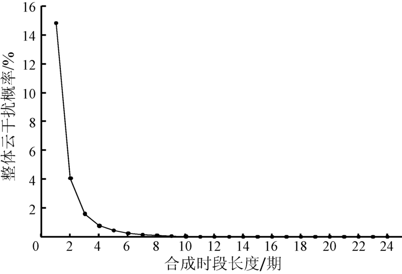
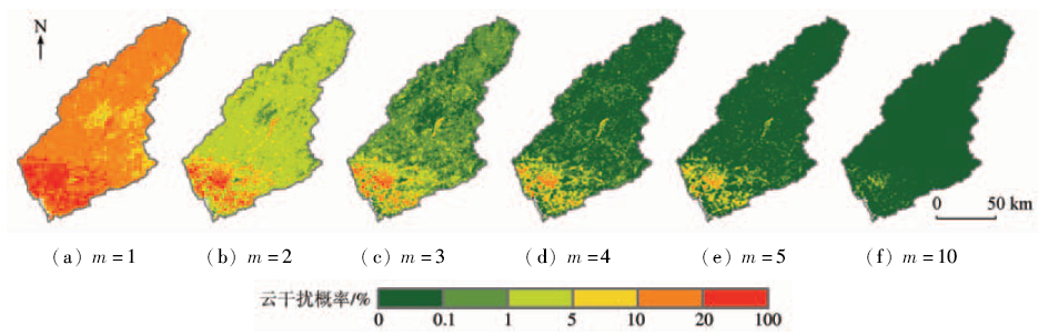
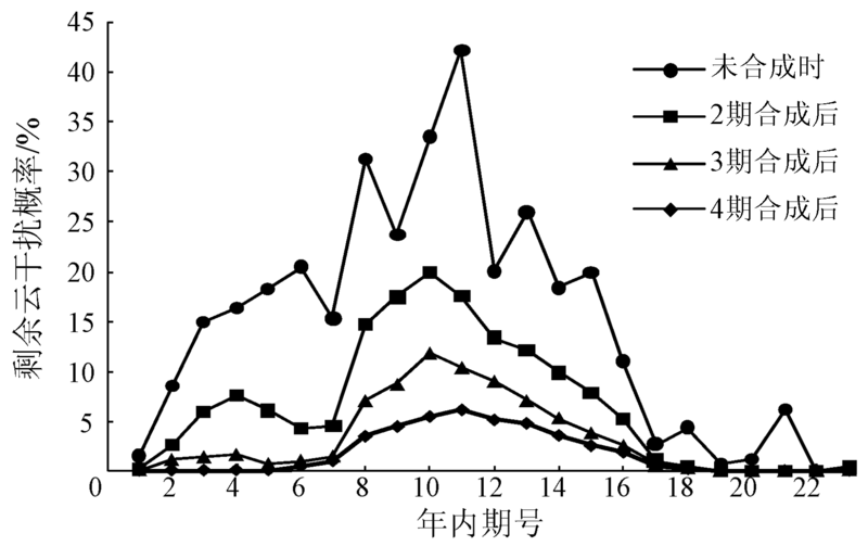
In this paper, the authors aim to clarify the spatio-temporal patterns of cloud interference in Dongjiang River basin and then provide scientific basis for vegetation index studies at the level of higher precision in this area. Cloud flag information of MOD13Q1 product data sets within the range of Dongjiang River basin from 2001 to 2015 were analyzed using the GIS approach. Three aspects were analyzed, i.e., the probability of cloud interference and its spatial distribution, the elimination rate of cloud interference and its spatial distribution and the seasonal differences of cloud interference duration period length. The results show that the whole probability of cloud interference was reduced rapidly with the increase of compounding period length, the new added elimination rate of cloud interference firstly increased and then decreased with the increase of compounding period length. The duration period length of cloud interference was relatively longer in southern urbanized region, and in summer and spring. The results of this study can provide scientific basis for choosing or developing better methods of removing clouds for vegetation index time-series data.
Chen Y,Fan J R,Wen X H,et al.Research on cloud removal from Landsat TM image based on spatial and temporal data fusion model[J].Remote Sensing Technology and Application,2015,30(2):312-320.
Xu X B,Yang G S.Spatial and temporal changes of multiple cropping index in 1995—2010 in Taihu Lake basin, China[J].Transactions of the Chinese Society of Agricultural Engineering,2013,29(3):148-155.
Zhang X W,Wu B F.A temporal transformation method of fractional vegetation cover derived from high and moderate resolution remote sensing data[J].Acta Ecologica Sinica,2015,35(4):1155-1164.
[6]
Holben B N.Characteristics of maximum-value composite images from temporal AVHRR data[J].International Journal of Remote Sensing,1986,7(11):1417-1434.
Song F Q,Xing K X,Liu Y,et al.Monitoring and assessment of vegetation variation in northern Shaanxi based on MODIS/NDVI[J].Acta Ecologica Sinica,2011,31(2):354-363.
[9]
Viovy N,Arino O,Belward A S.The best index slope extraction(BISE):A method for reducing noise in NDVI time-series[J].International Journal of Remote Sensing,1992,13(8):1585-1590.
[10]
Lovell J L,Graetz R D.Filtering pathfinder AVHRR land NDVI data for Australia[J].International Journal of Remote Sensing,2001,22(13):2649-2654.
[11]
Roerink G J,Menenti M,Verhoef W.Reconstructing cloudfree NDVI composites using Fourier analysis of time series[J].International Journal of Remote Sensing,2000,21(9):1911-1917.
[12]
Jonsson P,Eklundh L.Seasonality extraction by function fitting to time-series of satellite sensor data[J].IEEE Transactions on Geoscience and Remote Sensing,2002,40(8):1824-1832.
[13]
Beck P S A,Atzberger C,Høgda K A,et al.Improved monitoring of vegetation dynamics at very high latitudes:A new method using MODIS NDVI[J].Remote Sensing of Environment,2006,100(3):321-334.
[14]
Zhang X Y,Friedl M A,Schaaf C B,et al.Monitoring vegetation phenology using MODIS[J].Remote Sensing of Environment,2003,84(3):471-475.
[15]
Chen J,Jönsson P,Tamura M,et al.A Simple method for reconstructing a high-quality NDVI time-series data set based on the Savitzky-Golay filter[J].Remote Sensing of Environment,2004,91(3/4):332-344.
[16]
Ma M G,Veroustraete F.Reconstructing pathfinder AVHRR land NDVI time-series data for the northwest of China[J].Advances in Space Research,2006,37(4):835-840.
[17]
Atzberger C, Eilers P H C.Evaluating the effectiveness of smoothing algorithms in the absence of ground reference measurements[J].International Journal of Remote Sensing,2011,32(13):3689-3709.
Bian J H,Li A N,Song M Q,et al.Reconstruction of NDVI time-series datasets of MODIS based on Savitzky-Golay filter[J].Journal of Remote Sensing,2010,14(4):725-741.
Li W,Fang S H,Dian Y Y,et al.Cloud detection in MODIS data based on spectrum analysis[J].Geomatics and Information Science of Wuhan University,2005,30(5):435-438,443.
Shan N,Zheng T Y,Wang Z S.High-speed and high-accuracy algorithm for cloud detection and its application[J].Journal of Remote Sensing,2009,13(6):1138-1155.
 2018, Vol. 30
  ), 秦国玲1(