Please wait a minute...
 
国土资源遥感  2019, Vol. 31 Issue (3): 140-147    DOI: 10.6046/gtzyyg.2019.03.18
  技术应用 本期目录 | 过刊浏览 | 高级检索 |
基于HSI模型的吉林省东部地区生境质量动态评价
孟庆林1, 李明玉1(), 任春颖2, 王宗明2, 田艳林2
1. 延边大学理学院地理系,延吉 133002
2. 中国科学院东北地理与农业生态研究所湿地生态与环境重点实验室,长春 130102
Dynamic assessment of habitat quality in eastern Jilin Province based on HSI model
Qinglin MENG1, Mingyu LI1(), Chunying REN2, Zongming WANG2, Yanlin TIAN2
1. Department of Geography, College of Sciences, Yanbian University, Yanji 133002, China
2. Key Laboratory of Wetland Ecology and Environment, Northeast Institute of Geography and Agroecology, Chinese Academy of Sciences, Changchun 130102, China
全文: PDF(2892 KB)   HTML  
输出: BibTeX | EndNote (RIS)      
摘要 

生境质量评价对生物多样性保护具有重要意义,能够为生态环境的恢复和保护、区域可持续发展政策的制定提供科学依据。以吉林省东部地区为研究区,基于2000年和2015年2期Landsat TM/OLI影像和数字高程模型(digital elevation model,DEM)数据,选取水源状况、干扰因子、遮蔽条件及食物来源作为评价因子,采用层次分析法确定权重,建立了生境质量评价模型,对吉林省东部地区进行生境质量动态评价,并从评价因子、土地覆被变化、社会经济及气候变化等方面分析变化原因。结果表明,吉林省东部地区2000年生境质量最好和较好的区域分别占研究区总面积的37.69%和46.88%,2015年生境质量最好和较好的区域分别占研究区总面积的41.20%和44.66%; 2000—2015年间生境质量变好的区域为9 414.19 km 2,变差的区域为5 627.5 km 2; 土地覆被变化是导致生境质量变化的主要原因之一,吉林省大力发展生态旅游、退耕还林是生境质量变好的主要驱动力,气候条件适宜为吉林省东部地区生态环境保持长期稳定提供了有力保障。

服务
把本文推荐给朋友
加入引用管理器
E-mail Alert
RSS
作者相关文章
孟庆林
李明玉
任春颖
王宗明
田艳林
关键词 生境质量动态评价土地覆被变化气候变化    
Abstract

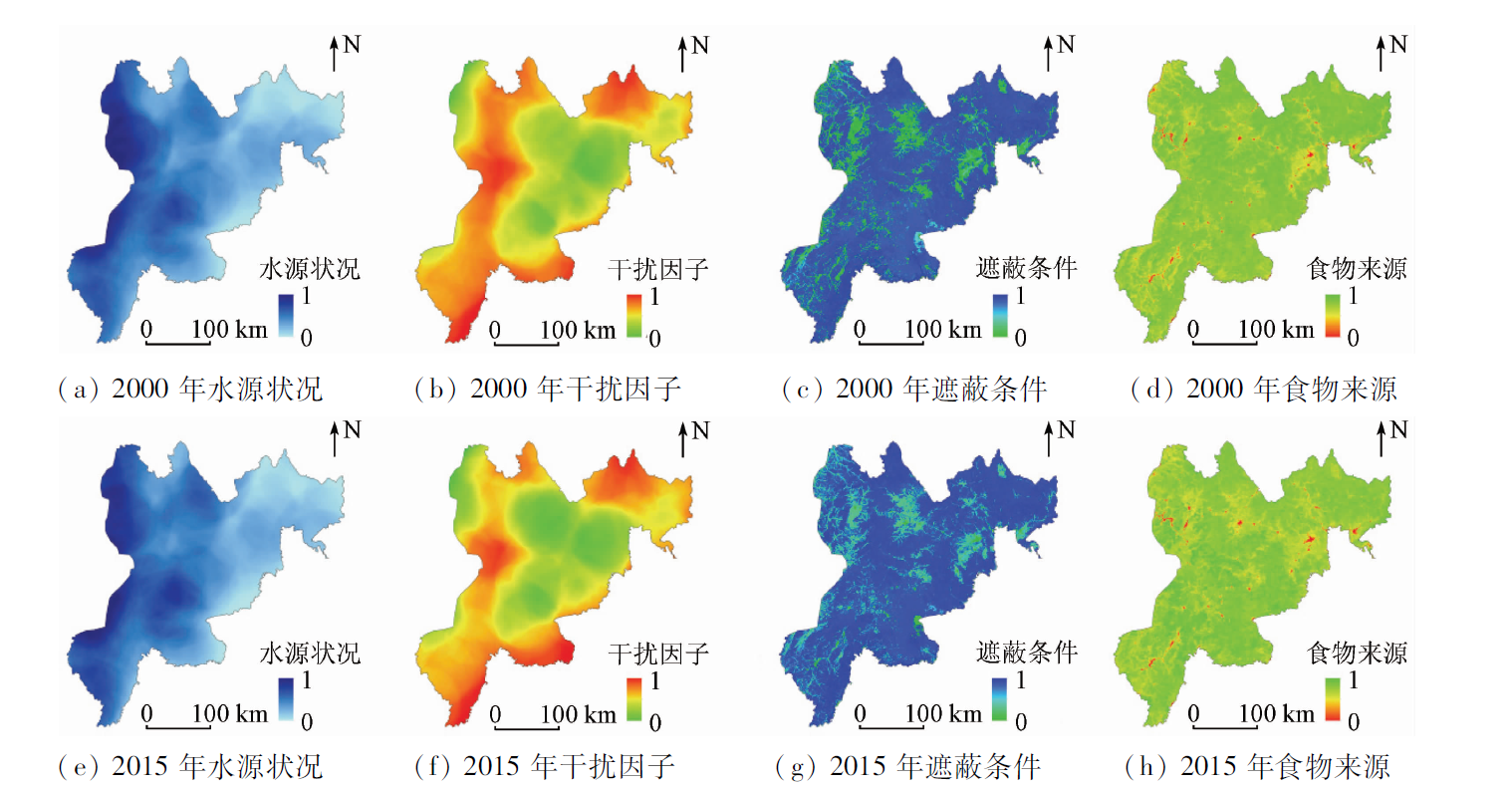
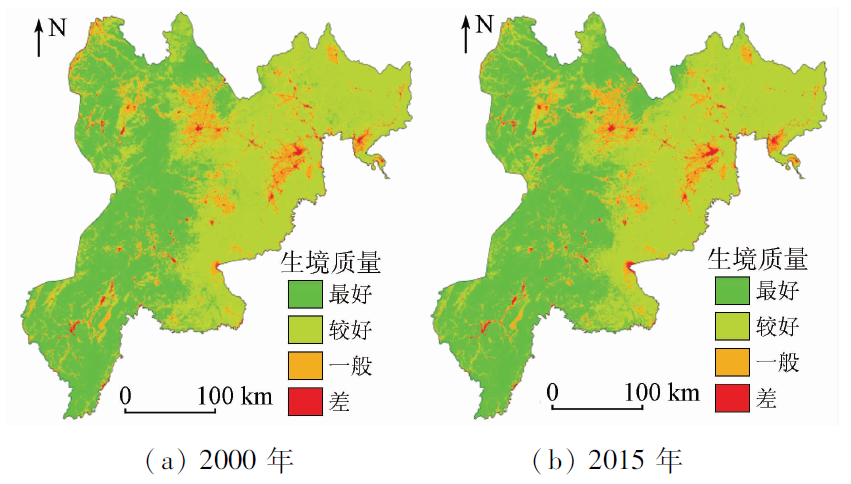
The assessment of habitat quality has important implications for the biodiversity conservation. It can provide scientific basis for the restoration and protection of the ecological environment and the formulation of regional sustainable development policies. Taking the east of Jilin Province as the study area and based on Landsat TM/OLI images and digital elevation model (DEM) data in 2000 and 2015, the authors selected water situation, degree of disturbance, shelters, and food source as evaluation factors. In addition, the analytic hierarchy process (AHP) was used to determine the weight, thus establishing a habitat quality evaluation model and making a dynamic assessment of the habitat quality in the eastern part of Jilin Province. Moreover, the reasons for change were analyzed from the aspects of assessment factors, land cover changes, social economy, and climate change. The results show that the areas of the best and better habitat quality in 2000 accounted for 37.69% and 46.88% of the study area respectively. The areas of the best and better habitat quality in 2015 accounted for 41.20% and 44.66% of the study area respectively. From 2000 to 2015, the area of habitat quality that got better was 9 414.19 km 2, and the area of habitat quality got worse, being 5 627.5 km 2. Land cover change is one of the causes of habitat quality change, and the vigorous development of eco-tourism and returning farmland to forests in Jilin Province constitute the main driving forces for improving the quality of the habitats. The suitable climatic conditions provide a powerful guarantee for the long-term stability of the ecological environment in the eastern part of Jilin Province.

Key wordshabitat quality    dynamic assessment    land cover change    climate change
收稿日期: 2018-06-14      出版日期: 2019-08-30
:  TP75  
基金资助:国家自然科学基金项目“延龙图地区城市生态用地评价与空间格局优化研究”(41461036);国家重点研发计划项目“东北森林生态系统监测与评估技术研究”共同资助(2016YFC0500301)
通讯作者: 李明玉
作者简介: 孟庆林(1994-),男,硕士研究生,研究方向为地图学与地理信息系统。Email: 879257445@qq.com.。
引用本文:   
孟庆林, 李明玉, 任春颖, 王宗明, 田艳林. 基于HSI模型的吉林省东部地区生境质量动态评价[J]. 国土资源遥感, 2019, 31(3): 140-147.
Qinglin MENG, Mingyu LI, Chunying REN, Zongming WANG, Yanlin TIAN. Dynamic assessment of habitat quality in eastern Jilin Province based on HSI model. Remote Sensing for Land & Resources, 2019, 31(3): 140-147.
链接本文:  
https://www.gtzyyg.com/CN/10.6046/gtzyyg.2019.03.18      或      https://www.gtzyyg.com/CN/Y2019/V31/I3/140
Fig.1  研究区地理位置示意图
目标层 准则层 决策层 生境质量分级标准
影响因子 权重 影响因子 权重 最好 较好 一般
生境质量 水源状况 0.3 河流密度/(km/ km2) 0.35 [1.2,+∞) [0.8,1.2) [0.4,0.8) [0,0.4)
湖泊密度/(个/km2) 0.65 [1.8,+∞) [1.2,1.8) [0.6,1.2) [0,0.6)
干扰因子 0.2 道路密度/(km/ km2) 0.45 [0,0.3) [0.3,0.6) [0.6,0.8) [0.8,+∞)
居民点密度/(个/km2) 0.55 [0,0.9) [0.9,1.8) [1.8,2.7) [2.7,+∞)
遮蔽条件 0.2 土地覆被类型 0.75 林地、湿地 草地 耕地 建设用地、裸地
坡度/(°) 0.25 [0,23) [23,40) [40,60) [60,90)
食物来源 0.3 NDVI 1 [0.5,1) [0.3,0.5) [0.1,0.3) [-1,0.1)
Tab.1  生境质量评价因子权重及分级标准
Fig.2  2000年和2015年生境质量评价因子分布
Fig.3  各评价因子得分增加的空间分布
Fig.4  研究区生境质量评估结果
年份 一般 较好 最好
面积/km2 比例/% 面积/km2 比例/% 面积/km2 比例/% 面积/km2 比例/%
2000年 1 437.69 1.63 12 160.63 13.80 41 296.56 46.88 33 202.88 37.69
2015年 1 460.69 1.66 10 999.56 12.48 39 343.75 44.66 36 292.19 41.20
Tab.2  2000年和2015年生境质量面积统计情况
Fig.5  2000—2015年间生境质量变化情况
评价因子 水源状况 干扰因子 遮蔽条件 食物来源
生境质量 0.204 1 -0.215 6 0.054 7 0.340 4
Tab.3  评价因子相关系数
Fig.6  研究区NDVI变化趋势
土地覆被类型 2015年
林地 草地 耕地 湿地 建设用地 裸地 总计
2000年 林地 69 151.14 19.49 1 384.63 95.65 105.86 14.58 70 771.36
草地 90.66 168.76 46.99 0.86 5.40 0.18 312.85
耕地 1 541.50 6.26 11 977.39 112.45 229.61 0.61 13 867.82
湿地 137.15 0.36 215.08 1 208.66 16.99 1.80 1 580.04
建设用地 6.78 0.19 2.80 5.90 1 108.96 0.49 1 125.12
裸地 34.70 0.02 2.15 2.46 0.42 225.10 264.85
总计 71 001.93 195.09 13 689.05 1 425.98 1 367.25 242.76
Tab.4  2000—2015年间土地利用状态转移矩阵
地区 GDP/亿元 人口/万 旅游人数/万人次
2000年 2015年 2000年 2015年 2000年 2015年
通化市 158.1 1034.45 137.4 882.8 225.25 221.1
白山市 93.6 690.15 90.2 769.2 132.74 125.4
延边州 171.5 886.06 207.2 1595.7 218.57 213.6
Tab.5  吉林省东部各市GDP、人口和旅游人数变化
Fig.7  研究区气温、降水量年际变化
[1] 李营, 张峰, 杨海军 , 等. 生物多样性生态功能区生境质量变化遥感监测研究[J]. 环境与可持续发展, 2016,41(2):46-48.
Li Y, Zhang F, Yang H J , et al. On habitat quality change monitoring by remote sensing in eco- functional area of biological diversity[J]. Environment and Sustainable Development, 2016,41(2):46-48.
[2] Raven P J, Holmes N T, Dawson F H , et al. River habitat quality:The physical character of rivers and streams in the UK and Isle of Man[J]. England:Environment Agency, 1998: 85.
[3] 阴琨, 李中宇, 赵然 , 等. 松花江流域水生态环境质量评价研究[J]. 中国环境监测, 2015,31(4):26-34.
Yin K, Li Z Y, Zhao R , et al. Study on assessment of water ecosystem quality in Songhua River Basin[J]. Environmental Monitoring in China, 2015,31(4):26-34.
[4] 赵志轩, 严登华, 耿雷华 , 等. 白洋淀东方大苇莺繁殖生境质量评价[J]. 应用生态学报, 2014,25(5):1483-1490.
Zhao Z X, Yan D H, Geng L H , et al. Nest habitat quality evaluation for the oriental great reed warbler(Acrocephalus orientalis) in Baiyangdian Wetland[J]. Chinese Journal of Applied Ecology, 2014,25(5):1483-1490.
[5] 王强, 袁兴中, 刘红 , 等. 基于河流生境调查的东河河流生境评价[J]. 生态学报, 2014,34(6):1548-1558.
doi: 10.5846/stxb201210201458
Wang Q, Yuan X Z, Liu H , et al. Stream habitat assessment of Dong River,China,using river habitat survey method[J]. Acta Ecologica Sinica, 2014,34(6):1548-1558.
[6] 王建宏, 蒲玫 . 甘肃大熊猫生境质量评价[J]. 动物学杂志, 2016,51(4):509-516.
Wang J H, Pu M . Habitat quality evaluation of Giant Panda(Ailuropoda melanoleuca) in Gansu[J]. Chinese Journal of Zoology, 2016,51(4):509-516.
[7] 王志强, 陈志超, 郝成元 . 基于HSI模型的扎龙国家级自然保护区丹顶鹤繁殖生境适宜性评价[J]. 湿地科学, 2009,7(3):197-201.
Wang Z Q, Chen Z C, Hao C Y . Breeding habitat suitability evaluation of red-crown crane in Zhalong National Nature Reserve by the method of habitat suitability index[J]. Wetland Science, 2009,7(3):197-201.
[8] Sherrouse B C, Semmens D J, Clement J M . An application of social values for ecosystem services(SolVES) to three national forests in Colorado and Wyoming[J]. Ecological Indicators, 2014,36:68-79.
[9] 吴健生, 曹祺文, 石淑芹 , 等. 基于土地利用变化的京津冀生境质量时空演变[J]. 应用生态学报, 2015,26(11):3457-3466.
Wu J S, Cao Q W, Shi S Q , et al. Spatio-temporal variability of habitat quality in Beijing-Tianjin-Hebei Area based on land use change[J]. Chinese Journal of Applied Ecology, 2015,26(11):3457-3466.
[10] 白杨, 郑华, 庄长伟 , 等. 白洋淀流域生态系统服务评估及其调控[J]. 生态学报, 2013,33(3):711-717.
doi: 10.5846/stxb201203270417
Bai Y, Zheng H, Zhuang C W , et al. Ecosystem services valuation and its regulation in Baiyangdian Baisn:Based on InVEST model[J]. Acta Ecologica Sinica, 2013,33(3):711-717.
[11] 金龙如, 孙克萍, 贺红士 , 等. 生境适宜度指数模型研究进展[J]. 生态学杂志, 2008,27(5):841-846.
doi:
Jin L R, Sun K P, He H S , et al. Research advances in habitat suitability index model[ J]. Chinese Journal of Ecology, 2008,27(5):841-846.
[12] 吴炳方, 苑全治, 颜长珍 , 等. 21世纪前十年的中国土地覆盖变化[J]. 第四纪研究, 2014,34(4):723-731.
doi: 10.3969/j.issn.1001-7410.2014.04.04
Wu B F, Yuan Q Z, Yan C Z , et al. Land cover changes of China from 2000 to 2010[J]. Quaternary Sciences, 2014,34(4):723-731.
[13] 孙健 . 基于面向对象分类土地利用分析[J]. 测绘与空间地理信息, 2018,41(1):185-188,192.
Sun J . Land use analysis based on object-oriented classification[J]. Geomatics and Spatial Information Technology, 2018,41(1):185-188,192.
[14] Lin Y P, Lin W C, Wang Y C , et al. Systematically designating conservation areas for protecting habitat quality and multiple ecosystem services[J]. Environmental Modelling and Software, 2017,90:126-146.
[15] Dong Z Y, Wang Z M, Liu D W , et al. Assessment of habitat suitability for water birds in the West Songnen Plain,China,using remote sensing and GIS[J]. Ecological Engineering, 2013,55:94-100.
[16] Bazzazi A A, Osanloo M, Karimi B . Deriving preference order of open pit mines equipment through MADM methods:Application of modified VIKOR method[J]. Expert Systems with Applications, 2010,38(3):2550-2556.
[17] 胡冬雪, 唐立娜, 邱全毅 , 等. 海峡西岸经济区景观格局10年变化及驱动力[J]. 生态学报, 2015,35(18):6138-6147.
doi: 10.5846/stxb201401180141
Hu D X, Tang L N, Qiu Q Y , et al. Decadal temporal changes in landscapes and their driving forces for West-bank Economic Zone of Taiwan Straits[J]. Acta Ecologica Sinica, 2015,35(18):6138-6147.
[18] 吉林省旅游局.吉林省旅游业发展“十二五”规划[EB/OL].(2011-3)[ 2018- 1- 26]. .
Jilin Provincial Tourism Bureau. The 12th Five-Year Plan for tourism development in Jilin Province[EB/OL].(2011-3)[ 2018- 1- 26]. .
[19] 中华人民共和国生态环境部.吉林省自然保护区名录[EB/OL].( 2013- 9- 27)[2018-1-26]. .
Ministry of Ecological Environment of the People’s Republic of China. Jilin Provincial nature reserve list[EB/OL].( 2013- 9- 27)[2018-1-26]. .
[20] 刘敏 . 吉林省天然林保护工程绩效分析及深入实施的对策研究[J].当代生态农业, 2010(3-4):58-61.
Liu M . Analysis of the performance of natural forest conservation project in Jilin Province and the countermeasures for in-depth implementation[J].Contemporary Eco-Agriculture, 2010(3-4):58-61.
[21] 姚晨光 . 吉林省退耕还林成果经验浅析[J].当代生态农业, 2013(3-4):54-56.
Yao C G . Experience of returning farmland to forest in Jilin Province[J].Contemporary Eco-Agriculture, 2013(3-4):54-56.
[22] 于德江, 宗盛伟, 杜海波 , 等. 吉林省东部森林地区气候变化分析[J]. 农业与技术, 2015,35(1):162-164,184.
Yu D J, Zong S W, Du H B , et al. Analysis of climate change in the forest area in the eastern part of Jilin Province[J]. Agriculture and Technology, 2015,35(1):162-164,184.
[1] 晋成名, 杨兴旺, 景海涛. 基于RS的陕北地区植被覆盖度变化及驱动力研究[J]. 自然资源遥感, 2021, 33(4): 258-264.
[2] 魏浩翰, 许仁杰, 杨强, 周权平. 多源卫星测高数据监测太湖水位变化及影响分析[J]. 自然资源遥感, 2021, 33(3): 130-137.
[3] 潘梦, 曹云刚. 高亚洲地区冰湖遥感研究进展与展望[J]. 国土资源遥感, 2021, 33(1): 1-8.
[4] 王佳新, 萨楚拉, 毛克彪, 孟凡浩, 罗敏, 王牧兰. 蒙古高原土壤湿度时空变化格局及其对气候变化的响应[J]. 国土资源遥感, 2021, 33(1): 231-239.
[5] 罗红霞, 戴声佩, 李茂芬, 李玉萍, 郑倩, 胡盈盈. 海南岛植被覆盖变化驱动因子及相对作用评价[J]. 国土资源遥感, 2020, 32(1): 154-161.
[6] 马超, 蔡盼丽. 徂徕山—莲花山地区环境生态指数时空变化与驱动因素分析[J]. 国土资源遥感, 2019, 31(4): 199-208.
[7] 张宇婷, 张振飞, 张志. 新疆大南湖荒漠区1992—2014年间植被覆盖度遥感研究[J]. 国土资源遥感, 2018, 30(1): 187-195.
[8] 郑朝菊, 曾源, 赵玉金, 赵旦, 吴炳方. 近15年中国西南地区植被覆盖度动态变化[J]. 国土资源遥感, 2017, 29(3): 128-136.
[9] 邢宇. 青藏高原32年湿地对气候变化的空间响应[J]. 国土资源遥感, 2015, 27(3): 99-107.
[10] 闫强, 廖静娟, 沈国状. 近40年乌兰乌拉湖变化的遥感分析与水文模型模拟[J]. 国土资源遥感, 2014, 26(1): 152-157.
[11] 黄卫东, 廖静娟, 沈国状. 近40年西藏那曲南部湖泊变化及其成因探讨[J]. 国土资源遥感, 2012, 24(3): 122-128.
[12] 路云阁, 刘晓, 张振德.
近32年三江源地区土地沙化特征及驱动力分析
[J]. 国土资源遥感, 2010, 22(s1): 72-76.
Viewed
Full text


Abstract

Cited

  Shared   
  Discussed   
京ICP备05055290号-2
版权所有 © 2015 《自然资源遥感》编辑部
地址:北京学院路31号中国国土资源航空物探遥感中心 邮编:100083
电话:010-62060291/62060292 E-mail:zrzyyg@163.com
本系统由北京玛格泰克科技发展有限公司设计开发