Please wait a minute...
 
国土资源遥感  2019, Vol. 31 Issue (4): 137-142    DOI: 10.6046/gtzyyg.2019.04.18
  技术应用 本期目录 | 过刊浏览 | 高级检索 |
基于高分一号遥感影像的植被覆盖遥感监测——以厦门市为例
彭继达, 张春桂()
福建省气象科学研究所,福州 350001
Remote sensing monitoring of vegetation coverage by GF-1 satellite: A case study in Xiamen City
Jida PENG, Chungui ZHANG()
Fujian Meteorological Science Institute, Fuzhou 350001, China
全文: PDF(2440 KB)   HTML  
输出: BibTeX | EndNote (RIS)      
摘要 

植被对环境变化有重要影响,特别是在碳循环中起着关键性作用。随着局地植被精细化监测要求的提高,传统中低分辨率遥感植被监测方式已经很难满足需求,而高分辨率卫星具有高空间分辨率优势,可以对植被进行更精细的遥感监测。本研究从高分一号卫星数据的特征出发,研究高分一号卫星数据辐射定标、大气校正和正射校正的预处理方法及高分一号卫星植被覆盖度遥感反演方法。最后,以福建省厦门市为例,利用高分一号多光谱相机(GF-1-WFV1)16 m影像数据反演植被覆盖度,并划分植被覆盖等级。根据植被覆盖度分布显示,高分一号卫星能精确监测厦门市植被覆盖度分布状况。监测统计结果表明,厦门市大部分地区为高或较高植被覆盖度区,其中,海沧、集美、翔安和同安内陆地区植被覆盖等级明显优于沿海地区,厦门岛南部地区植被覆盖度优于北部地区。

服务
把本文推荐给朋友
加入引用管理器
E-mail Alert
RSS
作者相关文章
彭继达
张春桂
关键词 高分一号卫星影像预处理植被覆盖度植被生态监测    
Abstract

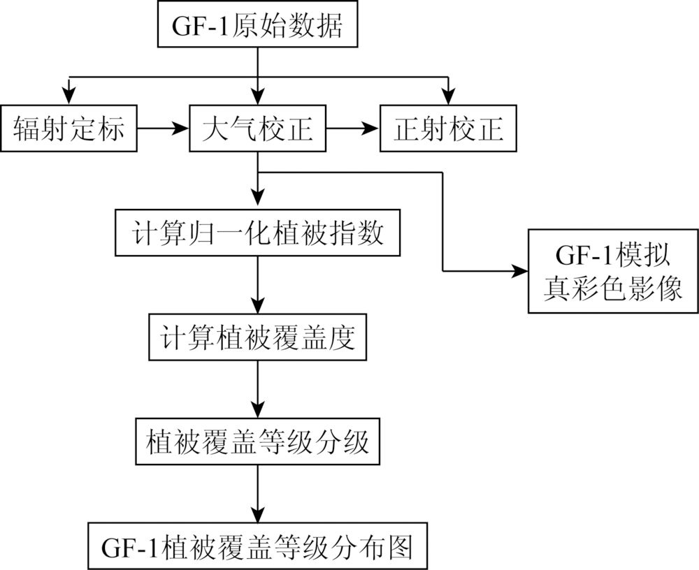
Forests have an important impact on global environmental change, especially in the carbon cycle. The demand of sensing monitoring for meteorological disasters, especially typhoon and flood, has become increasingly important. Traditional sensing monitoring of low and medium resolution can hardly meet the requirement. High resolution satellite has the advantage of high spatial resolution in vegetation monitoring. In this paper, the characteristics and pretreatment methods of GF-1 satellite images were studied in detail. The methods of radiation calibrater, atmospheric correction, ortho-rectification and calculating vegetation coverage were described in this paper. Finally, there was a case study of vegetation eco-environmental monitoring in Xiamen City. Researches show that most part of Xiamen belongs to high or higher vegetation coverage area, and the vegetation coverage in Haicang, Jimei, Xiangan and Tongan inland areas is significantly better than that in coastal areas. In the island of Xiangan, the vegetation coverage is better in the southern part than in the northern part.

Key wordsGF-1 satellite    image pretreatment    vegetation coverage    vegetation monitoring
收稿日期: 2018-11-07      出版日期: 2019-12-03
:  TP79  
基金资助:福建省气象科学研究所项目“基于卫星遥感的福建省近5年植被覆盖度变化特征分析”资助(kt201801)
通讯作者: 张春桂
作者简介: 彭继达(1987-),男,工程师,主要从事气象卫星资料应用研究。Email: pjida@163.com。
引用本文:   
彭继达, 张春桂. 基于高分一号遥感影像的植被覆盖遥感监测——以厦门市为例[J]. 国土资源遥感, 2019, 31(4): 137-142.
Jida PENG, Chungui ZHANG. Remote sensing monitoring of vegetation coverage by GF-1 satellite: A case study in Xiamen City. Remote Sensing for Land & Resources, 2019, 31(4): 137-142.
链接本文:  
https://www.gtzyyg.com/CN/10.6046/gtzyyg.2019.04.18      或      https://www.gtzyyg.com/CN/Y2019/V31/I4/137
类型 谱段号 谱段范
围/μm
空间分
辨率/m
幅宽/
km
侧摆
能力
重访时
间/d
全色相机 1 0.45~0.90 2 60 ±35° 4
8 m宽幅多光谱相机 2 0.45~0.52 8 60 ±35° 4
3 0.52~0.59
4 0.63~0.69
5 0.77~0.89
16 m宽幅多光谱相机 6 0.45~0.52 16 800 ±35° 2
7 0.52~0.59
8 0.63~0.69
9 0.77~0.89
Tab.1  GF-1卫星有效载荷技术指标
参数 指标
轨道类型 太阳同步回归轨道
轨道高度 645 km
轨道倾角 98.050 6°
降交点地方时 10: 30AM
回归周期 41 d
Tab.2  GF-1卫星轨道参数
Fig.1  植被覆盖遥感监测技术流程
Fig.2  GF卫星进行高、中、低反射率3个场地同步观测
卫星载荷 绝对辐射定标系数
Pan B1 B2 B3 B4
G B G B G B G B G B
GF-1 PMS1 0.122 8 0 0.142 4 0 0.117 7 0 0.119 4 0 0.113 5 0
GF-1 PMS2 0.136 5 0 0.146 0 0 0.124 8 0 0.127 4 0 0.125 5 0
GF-1 WFV1 / 0.216 5 0 0.168 5 0 0.135 4 0 0.150 7 0
GF-1 WFV2 / 0.209 7 0 0.163 0 0 0.133 9 0 0.152 1 0
GF-1 WFV3 / 0.187 0 0 0.161 9 0 0.129 5 0 0.138 3 0
GF-1 WFV4 / 0.177 0 0 0.152 1 0 0.132 2 0 0.134 9 0
Tab.3  2017年GF-1卫星绝对辐射定标系数
Fig.3  厦门GF-1-WFV1真彩色图像
Fig.4  厦门市植被覆盖度等级图
植被覆盖度
分类等级
像元数/个 面积/km2 所占植被覆盖总
面积百分比/%
83 697 21.43 1.6
较低 779 192 199.47 15.3
828 621 212.13 16.2
较高 766 330 196.18 15.0
2 642 288 676.43 51.8
Tab.4  不同等级植被覆盖度面积统计
[1] 东方星 . 我国高分卫星与应用简析[J].卫星应用,2015(3):44-48.
Dong F X . Analysis of high score satellites and their applications in China[J].Satellite application,2015(3):44-48.
[2] 王殿中, 何红艳 . 高分四号卫星观测能力与应用前景分析[J]. 航天返回与遥感, 2017,38(1):98-106.
Wang D Z, He H Y . Observation capability and application prospect of GF-4 Satellite[J]. Spacecraft Recovery and Remote Sensing, 2017,38(1):98-106.
[3] 马尚杰, 易湘生, 游炯 , 等. 基于GF-1影像的冬小麦种植面积核算及直补政策实施评价[J]. 农业工程学报, 2016,32(18):169-174.
Ma S J, Yi X S, You J , et al. Winter wheat cultivated area estimation and implementation evaluation of grain direct subsidy policy based on GF-1 imagery[J]. Transactions of the Chinese Society of Agricultural Engineering, 2016,32(18):169-174.
[4] 黄振国, 杨君 . 高分一号卫星影像监测水稻种植面积研究综述[J].湖南农业科学,2014(13):76-78.
Huang Z G, Yang J . Review of High-1 Satellite Image Monitoring Rice Planting Area[J].Hunan Agricultural Sciences,2014(13):76-78.
[5] 程灿然, 杨树文, 石鹏卿 . 基于高分一号卫星遥感影像的城市绿地提取对比研究[J]. 矿山测量, 2017,45(03):12-16.
Cheng C R, Yang S W, Shi P Q . Comparative research on urban green space extracting based on GF-1 satellite images[J]. Mine Surveying, 2017,45(03):12-16.
[6] 李杰, 谭荣建 . 基于高分1号卫星数据的农作物面积遥感测量[J]. 浙江农业科学, 2018,59(3):414-416.
Li J, Tan R J . Remote sensing measurement of crop area based on GF-1 satellite[J]. Journal of Zhejiang agricultural sciences, 2018,59(3):414-416.
[7] 胡倩伟, 左建章, 刘江 , 等. 高分一号卫星数据在土地覆盖动态监测中的应用研究[J]. 测绘与空间地理信息, 2016,39(6):63-66.
Hu J W, Zuo J Z, Liu J , et al. Research on GF-1 in the application of the land cover dynamic monitoring[J]. Geomatics and Spatial Information Technology, 2016,39(6):63-66.
[8] 唐世浩, 邱红, 马刚 . 风云气象卫星主要技术进展[J]. 遥感学报, 2016,20(5):842-849.
Tang S H, Qiu H, Ma G . Review on progress of the Fengyun meteorological satellite[J], Journal of Remote Sensing, 2016,20(5):842-849.
[9] 郑朝菊, 曾源, 赵玉金 , 等. 近15年中国西南地区植被覆盖度动态变化[J]. 国土资源遥感, 2017,29(3):128-136.doi: 10.6046/gtzyyg.2017.03.19.
Zheng Z J, Zeng Y, Zhao Y J , et al. Monitoring and dynamic analysis of fractional vegetation cover in southweatern China over the past 15 years based on MODIS data[J]. Remote Sensing for Land and Resources, 2017,29(3):128-136.doi: 10.6046/gtzyyg.2017.03.19.
[10] 侯旭洲, 易维宁, 乔延利 , 等. 基于6S模型的遥感图像大气校正方法[J]. 大气与环境光学学报, 2015,10(1):62-68.
Hou X Z, Yi W N , Qiao Y L,etal.Atmospheric correction of remote sensing image based on 6S model[J]. Journal of Atmospheric and Environmental Optics, 2015,10(1):62-68.
[11] 徐萌, 郁凡, 李亚春 , 等. 6S模式对EOS/MODIS数据进行大气校正的方法[J].南京大学学报(自然科学版),2006(06):582-589.
Xu M, Yu F, Li Y C ,et al.The method of atmospheric correction on the EOS/MODIS data with 6S model[J].Journal of Nanjing University(Natural Sciences),2006(06):582-589.
[12] 喻素芳, 佘光辉, 罗叶红 , 等. 基于MODIS-NDVI数据广西植被覆盖变化特征分析[J]. 湖北农业科学, 2015,54(2):321-325.
Yu S F, She G H, Luo Y H , et al. Analysis of characteristics of vegetation cover change in Guangxi Province based on MODIS-NDVI[J]. Hubei Agricultural Sciences, 2015,54(2):321-325.
[13] 王园香, 唐世浩, 郑照军 . 1982—2006年中国5—9月的NDVI变化与人类活动影响分析[J]. 地球信息科学学报, 2015,17(11):1333-1340.
doi: 10.3724/SP.J.1047.2015.01333
Wang Y X, Tang S H, Zheng Z J . Analysis of NDVI and the impact of human activity in China from May to September During 1982 to 2006[J]. Journal of Geo-information Science, 2015,17(11):1333-1340.
[14] 王爱芸, 赵志芳 . 基于遥感的植被覆盖度估算方法研究进展[J].绿色科技,2015(03):10-14.
Wang A Y, Zhao Z F . Research advances on the method of estimating vegetation coverage based on remote sensing[J].Journal of Green Science and Technology,2015(03):10-14.
[15] 李苗苗 . 植被覆盖度的遥感估算方法研究[D]. 中国科学院遥感应用研究所, 2003.
Li M M . The Method of Vegetation Fraction Estimation by Remote Sensing[D]. Remote sensing application institute of Chinese Academy of Sciences, 2003.
[16] 叶娇珑, 何政伟, 翁中银 , 等. NDVI像元二分模型在喀斯特地区提取石漠化中的应用[J].地理空间信息,2012(4):134-136.
Ye J L, He Z W, Weng Z Y , et al. Applicationof NDVI pixel binary model in extraction of rocky desertification in Karst areas[J].Geospatial Information,2012(4):134-136.
[17] 张宇婷, 张振飞, 张志 . 新疆大南湖荒漠区1992—2014年间植被覆盖度遥感研究[J]. 国土资源遥感, 2018,30(1):187-195.doi: 10.6046/gtzyyg.2018.01.26.
Zhang Y T, Zhang Z F, Zhang Z . Remote sensing study of vegetation coverage during the period 1992-2014 in Dananhu desert area,Xinjiang[J]. Remote Sensing for Land and Resources, 2018,30(1):187-195.doi: 10.6046/gtzyyg.2018.01.26.
[1] 晋成名, 杨兴旺, 景海涛. 基于RS的陕北地区植被覆盖度变化及驱动力研究[J]. 自然资源遥感, 2021, 33(4): 258-264.
[2] 陈虹, 郭兆成, 贺鹏. 1988—2018年间洱海流域植被覆盖度时空变换特征探究[J]. 国土资源遥感, 2021, 33(2): 116-123.
[3] 程宇琪, 王雨晴, 孙静萍, 张成福. 多伦县草原植被覆盖与蒸散量时空变化及其关系[J]. 国土资源遥感, 2020, 32(1): 200-208.
[4] 赖家明, 杨武年. 基于RS的川西天然林区近29年植被覆盖动态变化[J]. 国土资源遥感, 2018, 30(4): 132-138.
[5] 张晓东, 刘湘南, 赵志鹏, 赵银鑫, 马玉学, 刘海燕. 基于像元二分法的盐池县植被覆盖度与地质灾害点时空格局分析[J]. 国土资源遥感, 2018, 30(2): 195-201.
[6] 张宇婷, 张振飞, 张志. 新疆大南湖荒漠区1992—2014年间植被覆盖度遥感研究[J]. 国土资源遥感, 2018, 30(1): 187-195.
[7] 王瑞军, 董双发, 孙永彬, 李婧玥. 基于高分一号卫星数据新疆索拉克地区控矿地质单元遥感解译与应用[J]. 国土资源遥感, 2017, 29(s1): 137-143.
[8] 张成才, 罗蔚然, 窦小楠, 王金鑫. 应用Landsat8数据改进FCD模型方法[J]. 国土资源遥感, 2017, 29(4): 33-38.
[9] 郑朝菊, 曾源, 赵玉金, 赵旦, 吴炳方. 近15年中国西南地区植被覆盖度动态变化[J]. 国土资源遥感, 2017, 29(3): 128-136.
[10] 刘英, 侯恩科, 岳辉. 基于MODIS的神东矿区植被动态监测与趋势分析[J]. 国土资源遥感, 2017, 29(2): 132-137.
[11] 张焜, 李晓民, 马世斌, 刘世英, 李生辉. GF-1图像在中印边境楚鲁松杰村地质灾害调查中的应用[J]. 国土资源遥感, 2016, 28(2): 139-148.
[12] 何海燕, 凌飞龙, 汪小钦, 梁志锋. 基于雷达植被指数的水土流失区植被覆盖度估测[J]. 国土资源遥感, 2015, 27(4): 165-170.
[13] 李钰溦, 贾坤, 魏香琴, 姚云军, 孙俊, 牟丽秋. 中国北方地区植被覆盖度遥感估算及其变化分析[J]. 国土资源遥感, 2015, 27(2): 112-117.
[14] 刘亚迪, 汪小钦, 江洪. 基于地形调节植被指数估算长汀县植被覆盖度[J]. 国土资源遥感, 2015, 27(1): 164-171.
[15] 高闪闪, 陈仁喜. 适于ALOS图像植被信息提取的新植被指数[J]. 国土资源遥感, 2013, 25(4): 48-52.
Viewed
Full text


Abstract

Cited

  Shared   
  Discussed   
京ICP备05055290号-2
版权所有 © 2015 《自然资源遥感》编辑部
地址:北京学院路31号中国国土资源航空物探遥感中心 邮编:100083
电话:010-62060291/62060292 E-mail:zrzyyg@163.com
本系统由北京玛格泰克科技发展有限公司设计开发