Dynamic changes of vegetation cover in natural forest area of western Sichuan in recent 29 years based on RS
Jiaming LAI1,2, Wunian YANG1()
1. College of Earth Science, Chengdu University of Technology, Chengdu 610059, China 2. College of Forestry, Sichuan Agricultural University, Chengdu 611130, China
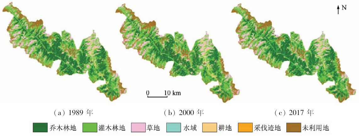
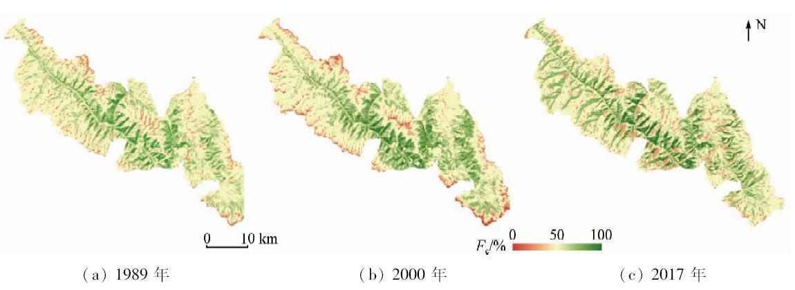
Monitoring the effectiveness of natural forest protection project (NFPP) is of great significance. In order to know about the changes of natural forest in western Sichuan before and after the implementation of the NFPP, based on the comparative analysis of land cover classification results of Landsat series remote sensing images in 1989, 2000 and 2017, the characteristics of vegetation cover change in western Sichuan natural forest area in recent 29 years were compared and analyzed. The results showed that the vegetation coverage of the natural forest area in western Sichuan was declining as a whole before the NFPP from 1989 to 2000, and it showed a slow rising trend after the projection from 2000 to 2017. The vegetation coverage area which were middle grade and above decreased 6 291.56 hm 2 before the projection and 4 384.01 hm 2 increased after that. The land cover types in the study area in the last 29 years were dominated by arbor forest and shrub forest, and the area transfer occurred mainly between them. In the past 29 years, the change of farmland area was obvious, which increased before the NFPP and decreased after that. In the last 29 years, the forest coverage rate in the study area was rapidly decreasing at first and then slowly increasing. The rate dropped to 61.77% from 1989 to 2000, a decrease of 2.57%, then slowly rose to 65.61% from 2000 to 2017, and the increase was 3.84%. The results of the study show that the implementation of the NFPP has been effectively protecting the natural forest resources in western Sichuan.
赖家明, 杨武年. 基于RS的川西天然林区近29年植被覆盖动态变化[J]. 国土资源遥感, 2018, 30(4): 132-138.
Jiaming LAI, Wunian YANG. Dynamic changes of vegetation cover in natural forest area of western Sichuan in recent 29 years based on RS. Remote Sensing for Land & Resources, 2018, 30(4): 132-138.
Bonan G B . Forests and climate change:Forcings,feedbacks,and the climate benefits of forests[J]. Science. 2008,320:1444-1449.
doi: 10.1126/science.1155121
Wang X C, Wang C K . Fundamental concepts and field measurement methods of carbon cycling in forest ecosystems:A review[J]. Acta Ecologica Sinica, 2015,35(13):4241-4256.
Aotegenqimuge, Qin F C, Zhou J N , et al. Different forest litters water-holding performance in Duolun County of Inner Mongolia Autonomous Region[J]. Bulletin of Soil and Water Conservation, 2017,37(4):114-118.
Ma W L, Shi P L, Zong N , et al. Water conservation capacity of forest ecosystems in Taihang Mountain[J]. Chinese Journal of Eco-Agriculture, 2017,25(4):478-489.
Zhou B, Yu X X, Chen L H , et al. Soil erosion simulation in mountain areas of Beijing based on InVEST model[J]. Research of Soil and Water Conservation, 2010,17(6):9-13.
Yan S Y, Wang J Y, Gong W , et al. Effects of forest change on soil physical properties and anti-erodibility in southern Sichuan Mountains[J]. Resources and Environment in the Yangtze Basin, 2016,25(7):1112-1120.
Cui G Y, Chen Y M, Cao Y , et al. Analysis on carbon stock distribution patterns of forest ecosystems in Shaanxi Province[J]. Chinese Journal of Plant Ecology, 2015,39(4):333-342.
Zhang K S, Shang Q, Liu Y C , et al. Differences in soil respiration between plantation and natural forest among different climate zones in China[J]. Ecological Science, 2017,36(6):49-56.
He F L, Xu X Y, Wei Q S , et al. A study on the comparison of community structural characteristics and species diversity between plantations and natural forests of Picea Crassifolia in Qilian Mountains[J]. Journal of Northwest Forestry University, 2016,31(5):1-7.
Liu S R, Ma J M, Miao N . Achievements in natural forest protection, ecological restoration, and sustainable management in China[J]. Acta Ecologica Sinica, 2015,35(1):0212-0218.
Tao Y Z, Lyu Y H, Li F Q , et al. Assessment of ecological effect of the natural forest protection project in Southwest China[J]. Journal of Ecology and Rural Environment, 2016,32(5):716-723.
Liu B, Yang W Q, Wu F Z . Advances in the subalpine forest ecosystem processes[J]. Acta Ecologica Sinica, 2010,30(16):4476-4483.
[15]
刘纪远 . 中国资源环境遥感宏观调查与动态研究[M]. 北京: 中国科学技术出版社, 1996.
Liu J Y. Remote Sensing Macroscopic Investigation and Dynamic Research of China’s Resources and Environment[M]. Beijing: Chinese Science and Technology Press, 1996.
[16]
Gitelson A A, Kaufman Y J, Stark R , et al. Novel algorithms for remote estimation of vegetation fraction[J]. Remote Sensing of Environment, 2002,80(1):76-87.
doi: 10.1016/S0034-4257(01)00289-9
Zhang X L, Zhang Y, Niu D K , et al. Spatial-temporal dynamics of upland meadow coverage on Wugong Mountain based on TM NDVI[J]. Acta Ecologica Sinica, 2018,38(7):2414-2424.
Tian C, Ma X Q, Wang W H , et al. Vegetation cover changes and its influence factors in eastern Jilin Province[J]. Journal of Fujian Agriculture and Forestry University (Natural Science Edition), 2017,46(4):410-417.
Zheng Z J, Zeng Y, Zhao Y J , et al. Monitoring and dynamic analysis of fractional vegetation cover in southwestern China over the past 15 years based on MODIS data[J]. Remote Sensing for Land and Resources, 2017,29(3):128-136.doi: 10.6046/gtzyyg.2017.03.19.
Yan M, Li Z Y, Chen E X , et al. Vegetation fractional coverage change in Daxinganling Genhe forest reserve of Inner Mongolia[J]. Chinese Journal of Ecology, 2016,35(2):508-515.
Zhu H L, Yang G H, Han L . Analysis of fractional vegetation coverage changes and its influence factors during farmland returned to forest period in Yan’an City[J]. Transactions of the Chinese Society for Agricultural Machinery, 2015,46(8):272-280.
Wang W H, Ma X Q, Zou X H , et al. Spatiotemporal variations of vegetation change in Fujian Province from 2000 to 2010[J]. Research of Soil and Water Conservation, 2017,24(4):234-239.
[23]
Qi J, Marsett R C, Moran M S , et al. Spatial and temporal dynamics of vegetation in the San Pedro River basin area[J]. Agricultural and Forest Meteorology, 2000,( 105):55-68.
doi: 10.1016/S0168-1923(00)00195-7
Miao Z H, Liu Z M, Wang Z M , et al. Dynamic monitoring of vegetation fraction change in Jilin Province based on MODIS NDVI[J]. Remote Sensing Technology and Application, 2010,25(3):387-393.
Zhang Y J, Ding J L, Zhang F , et al. Spatial differences of variations of vegetation coverage and the relationship with climatic factors in Bayramaly Oasis[J]. Journal of China Agricultural University, 2013,18(5):62-68.
[26]
赵英时 . 遥感应用分析原理与方法[M]. 北京: 科学出版社, 2002, 372-387.
Zhao Y S. Principle and Method of Remote Sensing Application Analysis[M]. Beijing: Science Press, 2002, 372-387.
Li M M, Wu B F, Yan C Z , et al. Estimation of vegetation fraction in the upper basin of Miyun Reservoir by remote sensing[J]. Resources Science, 2004,26(4):153-159.
Ye J L, He Z W, Weng Z Y , et al. Application of NDVI pixel binary model in extraction of rocky desertification in Karst areas[J].Geospatial Information,2012(4):134-136.
Zhou Z Y, Chu S L, Wang Z W , et al. Analysis of vegetation coverage change based on NDVI:A case study in Ganzhou Area, Zhangye City,Gansu[J]. Pratacultural Science, 2008,25(12):23-29.
Zhang Y T, Zhang Z F, Zhang Z . Remote sensing study of vegetation coverage during the period 1992—2014 in Dananhu desert area,Xinjiang[J]. Remote Sensing for Land and Resources, 2018,30(1):187-195.doi: 10.6046/gtzyyg.2018.01.26.
Guo Z, Nie H, Zang R G . Evaluation on comprehensive benefit of natural forest protection project in Southwest China[J]. Journal of Anhui Agricultural Science, 2011,39(24):15035-15038.
 2018, Vol. 30
  )
)