Application of hyperspectral remote sensing data-based anomaly extraction in copper-gold prospecting in the Solake area in the Altyn metallogenic belt, Xinjiang
WANG Qian1(), REN Guangli2()
1. China Railway Cadre Management Training Academy, Xianyang 712000, China 2. Xi’an Center of Geological Survey, China Geological Survey, Xi’an, 710054, China
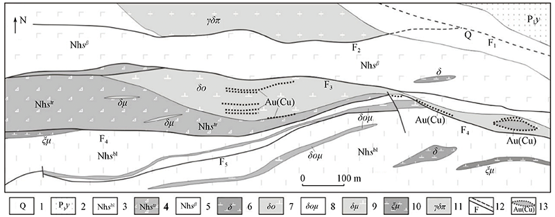
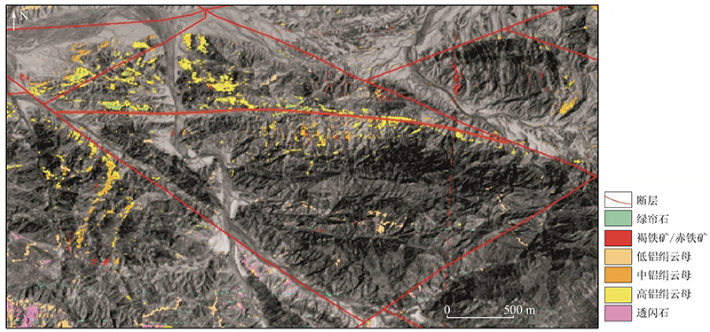
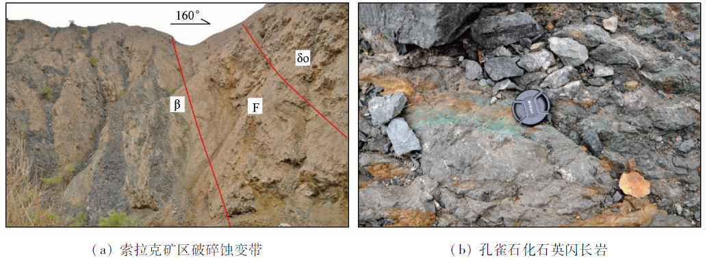
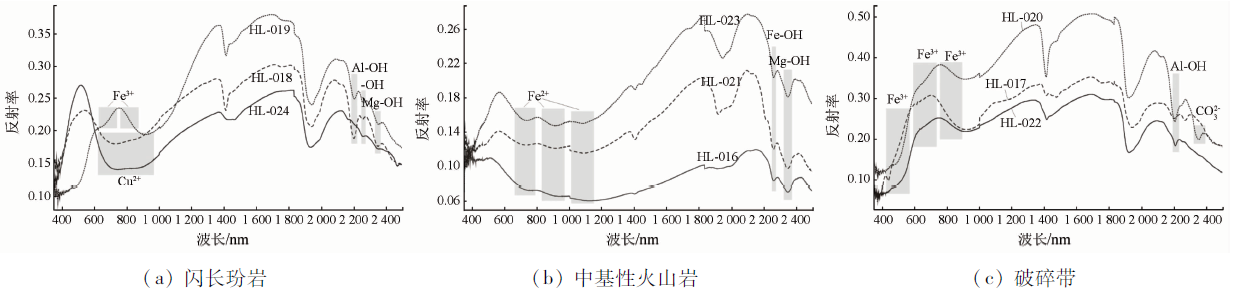
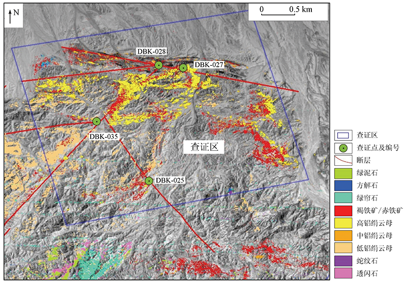
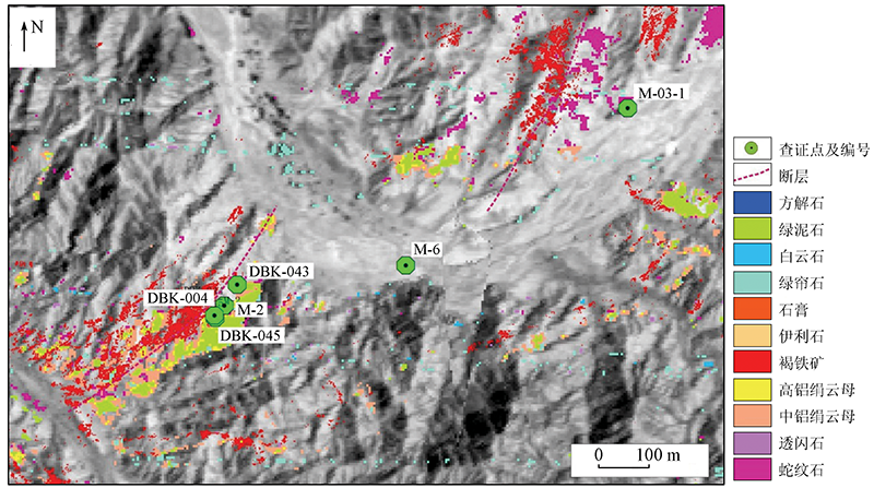
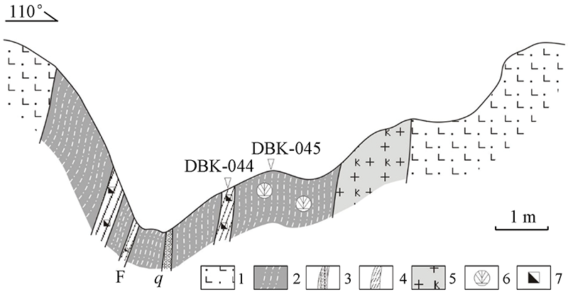
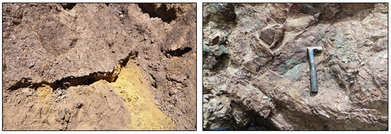
This study extracted and analyzed the altered mineral anomalies in the Suolake area in the Altyn metallogenic belt, Xinjiang using the airborne hyperspectral remote sensing data (CASI/SASI). Based on this, the distribution pattern and genesis of the altered mineral anomalies in the area were summarized. Then, the spectral curve characteristics of altered minerals from different geologic bodies were analyzed and summarized according to the ground spectrum measurement of typical rocks and minerals. Meanwhile, the spectral measurement and analysis of the geologic profiles of altered minerals in the Suolake copper-gold deposit were conducted. Then, representative altered mineral assemblages were determined, and the hyperspectral remote sensing prospecting model based on gold deposits in this area was established. Base on metallogenic geological setting and geochemical anomaly characteristics, this study explored the application of hyperspectral remote sensing data-based anomaly extraction in metallogenic prediction. The results verified that the anomaly areas delineated using hyperspectral remote sensing data have favorable gold mineralization, suggesting that hyperspectral remote sensing can provide accurate and reliable information for ore prospecting.
王茜, 任广利. 高光谱遥感异常信息在阿尔金索拉克地区铜金矿找矿工作中的应用[J]. 自然资源遥感, 2022, 34(1): 277-285.
WANG Qian, REN Guangli. Application of hyperspectral remote sensing data-based anomaly extraction in copper-gold prospecting in the Solake area in the Altyn metallogenic belt, Xinjiang. Remote Sensing for Natural Resources, 2022, 34(1): 277-285.
Zhou K F, Sun L, Zhang N N. Identification and extraction of ground object alteration information by hyperspectral remote sensing in Central Asia area[M]. Beijing: Geological Publishing House, 2008:1-16.
Zhang Z G, Wang R S. Imaging spectrometer remote sensing methodological technology and it’s application based on spectroscopy[J]. Remote Sensing for Land and Resources, 2000, 12(3):16-37.doi: 10.6046/gtzyyg.2000.03.03.
doi: 10.6046/gtzyyg.2000.03.03
Li Z Z, Yang R H, Dang F X, et al. The hyperspectral remote sensing technology and its application[J]. Geological Bulletin of China, 2009, 28(2-3):270-277.
Wang R S, Gan P P, Yan B K, et al. hyperspectral mineral mapping and its application[J]. Remote Sensing for Land and Resources, 2010, 22(1):1-13.doi: 10.6046/gtzyyg.2010.01.01.
doi: 10.6046/gtzyyg.2010.01.01
Gu P Y, Chen R M, Cha X F, et al. Exploration and practice of 1:50 000 geological mapping techniques for alpine-gorge area:A case study in Beishan area of Wushi,Xinjiang[J]. Journal of Geomechanics, 2016, 22(4):837-855.
Ren G L, Yang J L, Yang M, et al. Application of hyperspectral remote sensing anomaly information on metallogenic prediction in the Jintanzi-Mingjingou area of Beishan,Gansu[J]. Geotectonica et Metallogenia, 2013, 37(4):765-776.
Ren G L, Yang M, Li J Q, et al. Application of hyperspecntral alteration information to gold prospecting:A case study of Fangshankou area,Beishan[J]. Remote Sensing for Land and Resources, 2017, 29(3):182-190.doi: 10.6046/gtzyyg.2017.03.27.
doi: 10.6046/gtzyyg.2017.03.27
Liu D C, Yan B K, Qiu J T, et al. The application of airborne hyper-spectral remote sensing technology to mineral resources exploration[J]. Acta Geoscientica Sinica, 2016, 37(3):349-358.
Sun Y, Zhao Y J, Qin K, et al. Ore-forming factors and prospecting of jade ore using airborne hyperspectral data:Taken the Nachitai area in Qinghai Province as an example[J]. Geological Review, 2017, 63(s1):203-204.
Yi H, Li J Q, Han H H, et al. Application of remote sensing in integrated survey on mineral exploration in Beketan,Altyn[J]. Geological Survey of China, 2016, 3(4):1-5.
Wang R J, Dong S F, Sun Y B, et al. A study on remote sensing interpretation of metallogenic information elements and its application in Suolake area of Xinjiang[J]. Mineral Resources and Geology, 2016, 30(6):972-979.
Wang R J, Sun Y B, Li M S, et al. Hyperspectral alteration mineral prospecting marks of Panlonggou gold deposit,Aerjin,Xinjian[J]. Contribtions to Geology and Mineral Resources Research, 2017, 32(2):300-311.
Yan B K, Dong X F, Wang Z, et al. Mineral information extraction technology by airborne hyperspectral remote sensing and its application progress:An example of mineralization belts of western China[J]. Geological Survey of China, 2016, 3(4):55-62.
[14]
Zhang J X, Zhang Z M, Xu Z Q, et al. Petrology and geochronology of eclogite from the western segment of the Altyn Tagh,northwern China[J]. Lithos, 2001, 56:187-206.
doi: 10.1016/S0024-4937(00)00052-9
Xu Z Q, Yang J S, Zhang J X, et al. A comparison between the tectonic units on the two sides of the Altyn sinistral strike-slip fault and the mechanism of lithospheric shearing[J]. Acta Geological Sinica, 1999(3):193-205.
[16]
Gao X F, Xiao P X, Guo L, et al. Opening of an early Paleozoic limited oceanic basin in the northern Altyn area:Constraints from plagiogranites in the Hongliugou-Lapeiquan ophiolitic mélange[J]. Science China Earth Sciences, 2011, 54:1871-1879.
doi: 10.1007/s11430-011-4332-9
[17]
Gao X F, Xiao P X, Kang L, et al. Late Ordovician back-arc extension in the southeastern margin of the Tarim Craton,NW China:Elemental and Sr-Nd isotopic constraints from the Hongliugou basalts[J]. Geochemical Journal, 2019, 53:359-378.
doi: 10.2343/geochemj.2.0573
Sun Y, Liu C Y, Che Z C. The Proterozoic rift volcanic series in the Lapeiquan area,the Altun mountains and its tectonic significance[J]. Geological Review, 1997, 43(1):17-24.
Hu Y X, Xiao P X, Gao X F, et al. Division and space-time frame foundation of regional stratum in the western sector of east Kunlun and the Altun region[J]. Northwestern Geology, 2010, 43(4):152-158.
[21]
Lu S N, Li H K, Zhang C L, et al. Geological and geochronological evidence for the Precambrian evolution of the Tarim Craton and surrounding continental fragments[J]. Precambrian Reseach, 2008, 160:94-107.
[22]
邓书斌. ENVI遥感图像处理方法[M]. 北京: 科学出版社, 2010:361-373.
Deng S B. The method of ENVI remote sensing image processing[M]. Beijing: Science Press, 2010:361-373.
[23]
新疆维吾尔自治区地质矿产局. 新疆维吾尔自治区区域地质志[M]. 北京: 地质出版社, 1993.
Bureau of Geology and Mineral Resources of Xinjiang Uygur Autonomous Region. Regional geology of Xinjiang Uygur Autonomous Region[M]. Beijing: Geological Publishing House, 1993.
[24]
Bierwirth P, Huston D, Blewett R. Hyperspectral mapping of mineral assemblages associated with gold mineralization in the central Pilbara,Western Australia[J]. Economic Geology, 2002, 97:819-826.
doi: 10.2113/gsecongeo.97.4.819
[25]
van Ruitenbeek F J A, Debba P, van der Meer F D, et al. Mapping white micas and their absorption wavelengths using hyperspectral band ratios[J]. Remote Sensing of Environment, 2006, 102:211-222.
doi: 10.1016/j.rse.2006.02.012
 2022, Vol. 34
  ), 任广利2(