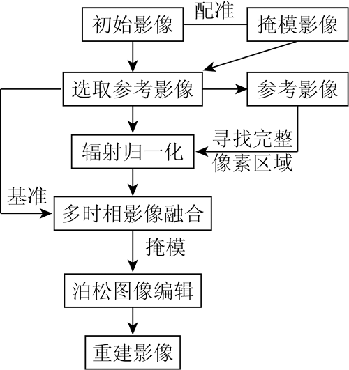
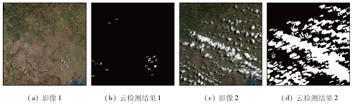
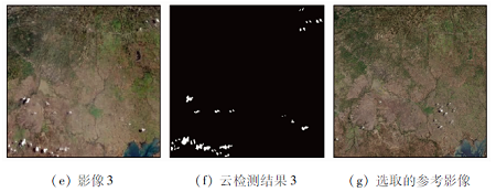
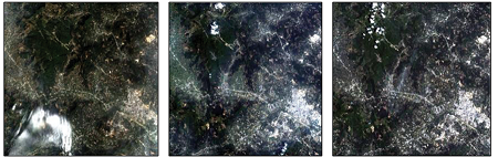
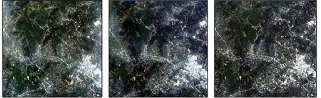
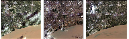
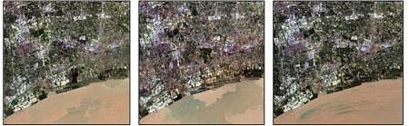
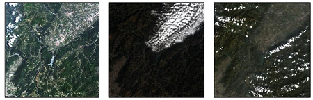
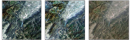
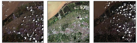
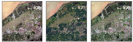
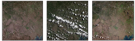
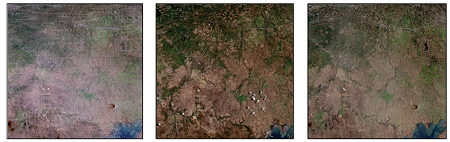
The cloud removal of remote sensing images is very important in the processing and analysis of remote sensing images and plays a crucial role in the subsequent image information extraction and other operations. Aiming at the high-quality requirements and low applicability of the reconstructed images in the cloud removal of multi-temporal remote sensing image fusion, a thick cloud removal algorithm based on one or more reference images was proposed, mainly including a selection of reference image, radiometric normalization, multi-temporal image fusion, and Poisson image editing. Firstly, the reference image was selected according to the image masking and the principal component information, and the radiometric normalization of the multi-source remote sensing image was carried out to preserve the change of ground feature information. Then, the image was fused based on the selective multi-source total variation model, and the boundary gradient discontinuity after image fusion was reduced by Poisson image editing. The experimental results show that the proposed method can effectively remove clouds from multi-source remote sensing images with thick clouds and different quality, and obtain higher image detail precision than traditional methods.
Guo H D. Radar for earth observation:Theory and applications[M]. Beijing: Science Press, 2000:15-20.
[2]
Shen H, Li X, Cheng Q, et al. Missing information reconstruction of remote sensing data:A technical review[J]. IEEE Geoscience & Remote Sensing Magazine, 2015, 3(3):61-85.
[3]
Rossi R E, Dungan J L, Beck L R. Kriging in the shadows:Geostatistical interpolation for remote sensing[J]. Remote Sensing of Environment, 1994, 49(1):32-40.
doi: 10.1016/0034-4257(94)90057-4
[4]
Meer F V D. Remote-sensing image analysis and geostatistics[J]. International Journal of Remote Sensing, 2012, 33(17-18):5644-5676.
doi: 10.1080/01431161.2012.666363
[5]
He K, Sun J. Image completion approaches using the statistics of similar patches[J]. IEEE Transactions on Pattern Analysis and Machine Intelligence, 2014, 36(12):2423-2435.
doi: 10.1109/TPAMI.2014.2330611
[6]
Guillemot C, Le M O, et al. Image inpainting:Overview and recent advances[J]. IEEE Signal Processing Magazine, 2013, 31(1):127-144.
doi: 10.1109/MSP.2013.2273004
[7]
Ng K P, Yuan Q, Yan L, et al. An adaptive weighted tensor completion method for the recovery of remote sensing images with missing data[J]. IEEE Transactions on Geoscience and Remote Sensing, 2017, 55(6):3367-3381.
doi: 10.1109/TGRS.2017.2670021
[8]
Shen H, Li H, Yan Q, et al. An effective thin cloud removal procedure for visible remote sensing images[J]. ISPRS Journal of Photogrammetry & Remote Sensing, 2014, 96:224-235.
[9]
Lv H, Wang Y, Shen Y. An empirical and radiative transfer model based algorithm to remove thin clouds in visible bands[J]. Remote Sensing of Environment, 2016, 179:183-195.
doi: 10.1016/j.rse.2016.03.034
[10]
Xu M, Jia X, Pickering M, et al. Thin cloud removal from optical remote sensing images using the noise-adjusted principal components transform[J]. ISPRS Journal of Photogrammetry and Remote Sensing, 2019, 149(MAR.):215-225.
doi: 10.1016/j.isprsjprs.2019.01.025
[11]
Chen J, Zhu X, Vogelmann J E, et al. A simple and effective method for filling gaps in Landsat ETM+ SLC-off images[J]. Remote Sensing of Environment, 2011, 115(4):1053-1064.
doi: 10.1016/j.rse.2010.12.010
[12]
Chen B, Bo H, Chen L, et al. Spatially and temporally weighted regression:A novel method to produce continuous cloud-free Landsat imagery[J]. IEEE Transactions on Geoscience and Remote Sensing, 2016, 55(1):27-37.
doi: 10.1109/TGRS.2016.2580576
[13]
Zhang Y, Wen F, Gao Z, et al. A coarse-to-fine framework for cloud removal in remote sensing image sequence[J]. IEEE Transactions on Geoscience and Remote Sensing, 2019:5963-5974.
[14]
Zeng C, Shen H, Zhang L. Recovering missing pixels for Landsat ETM+ SLC-off imagery using multi-temporal regression analysis and a regularization method[J]. Remote Sensing of Environment, 2013, 131:182-194.
doi: 10.1016/j.rse.2012.12.012
[15]
Li X, Shen H, Zhang L, et al. Recovering quantitative remote sensing products contaminated by thick clouds and shadows using multitemporal dictionary learning[J]. Geoscience & Remote Sensing, 2014, 52(11):7086-7098.
[16]
Zhang Q, Yuan Q, Li J, et al. Cloud and shadow removal for sentinel-2 by progressively spatiotemporal patch group learning[C]// IGARSS 2019-2019 IEEE International Geoscience and Remote Sensing Symposium.IEEE, 2019:775-778.
Dai C D, Lei L P. The information characteristics of thematic mapper data and the optimal band combination[J]. Remote Sensing of Environment China, 1989, 4(4):48-58.
[18]
Zhu Z, Woodcock C E. Automated cloud,cloud shadow,and snow detection in multitemporal Landsat data:An algorithm designed specifically for monitoring land cover change[J]. Remote Sensing of Environment, 2014, 152:217-234.
doi: 10.1016/j.rse.2014.06.012
Yu X M, Zou Q. Methods of radiometric normalization for multi-temporal remote sensing images:A review[J]. Geometrics and Spatial Information Technology, 2012, 35(6):19-23.
[20]
Turner M G, Gardner R H, O’Neill R V. Landscape ecology in theory and practice[M]. New York: Springer, 2001:108-125.
Shao Y P, Hong Y T. PIF method for relative radiometric correction of remote sensing images[J]. Remote Sensing for Land and Resources, 2017, 29(1):7-13.doi: 10.6046/gtzyyg.2017.01.02.
doi: 10.6046/gtzyyg.2017.01.02
[22]
Tierney S, Guo Y, Gao J. Selective multi-source total variation image restoration[C]// 2015 International Conference on Digital Image Computing: Techniquesand Applications (DICTA).IEEE, 2015:1-8.
[23]
Lin Z, Liu R, Su Z. Linearized alternating direction method with adaptive penalty for low-rank representation[J]. Advances in Neural Information Processing Systems, 2011:612-620.
[24]
Zuo W, Lin Z. A generalized accelerated proximal gradient approach for total-variation-based image restoration[J]. IEEE Transactions on Image Processing A Publication of the IEEE Signal Processing Society, 2011, 20(10):2748-2759.
doi: 10.1109/TIP.2011.2131665
[25]
Pérez P, Gangnet M, Blake A. Poisson image editing[J]. ACM Transactions on Graphics, 2003, 22(3):313-318.
doi: 10.1145/882262.882269
[26]
Pan H. Cloud removal for remote sensing imagery via spatial attention generative adversarial network[J/OL].(2020-11-14)[2020-09-28]. https://arxiv.org/abs/2009.13015.
 2022, Vol. 34
  ), 黄微, 黄睿