Fine classification of rice with multi-temporal compact polarimetric SAR based on SVM+SFS strategy
Xianyu GUO1, Kun LI2(), Zhiyong WANG1, Hongyu LI3, Zhi YANG4
1. College of Geomatics, Shandong University of Science and Technology, Qingdao 266590, China 2. Institute of Remote Sensing and Digital Earth, Chinese Academy of Sciences, Beijing 100101, China 3. School of Earth Science and Resources, China University of Geosciences(Beijing), Beijing 100083, China 4. Institute of Transmission and Transformation Engineering, China Electric Power Research Institute, Beijing 100055, China
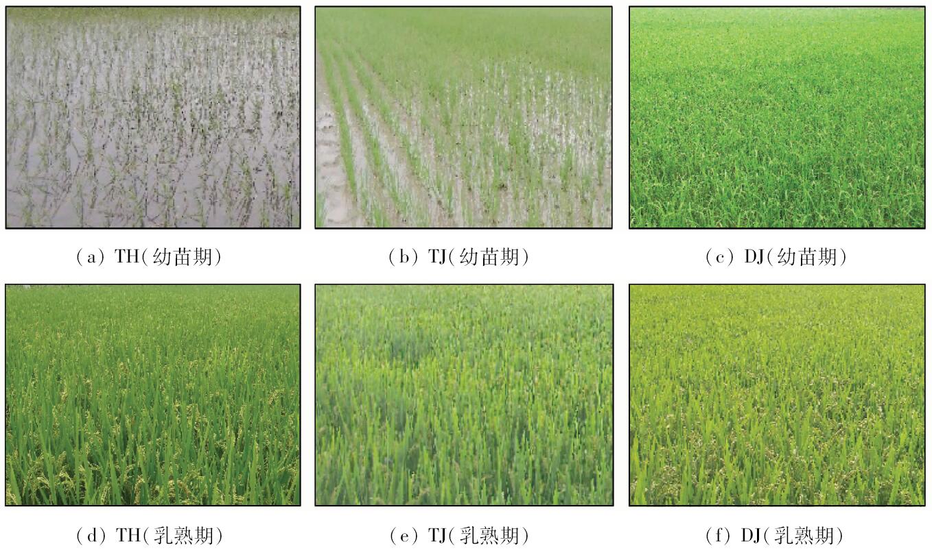
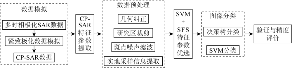
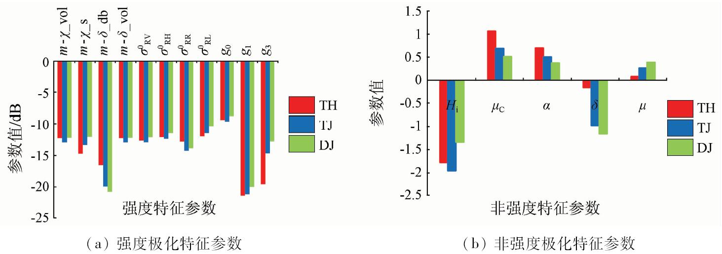
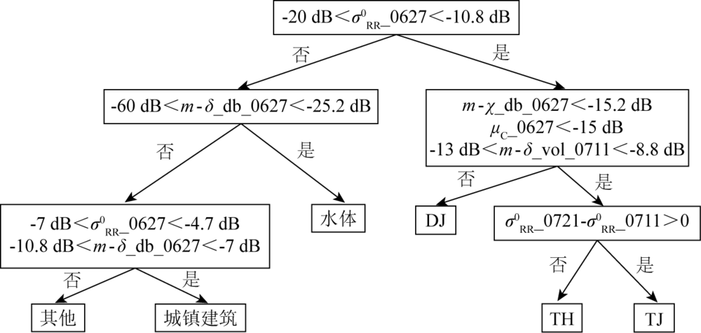
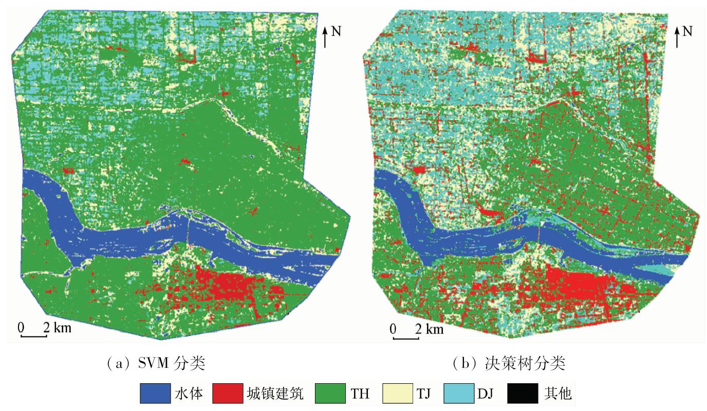
Different types and planting methods can result in the discrepancy of rice growth and yield. It is of great importance to provide accurate growth vigor information for rice growth monitoring and estimation using fine distinction of different rice varieties and planting methods. As a new type of SAR sensor, compact polarimetry synthetic aperture Radar (CP-SAR) provides the possibility for the fine mapping of paddy land with abundant polarimetric information and large width. In this study, the authors firstly used RADARSAT-2 fully polarimetric SAR data to simulate CP-SAR data and extracted 22 types of feature parameters. In addition, on the basis of the multi-dimensional feature information CP - SAR data, the support vector machine and sequential forward selection (SVM + SFS) strategy were performed for feature selection, and the optimal feature subset of paddy land fine classification was obtained. Moreover, the decision tree and SVM method were used for paddy land fine classification based on feature subset. The results show that paddy land fine classification method based on decision tree can achieve better classification results. The overall classification precision and Kappa coefficient of optimal feature subset respectively are 92.57% and 0.896, which are higher than those of the set of all feature parameters by improving 1.2% in overall classification precision and 0.016 in Kappa coefficient.
国贤玉, 李坤, 王志勇, 李宏宇, 杨知. 基于SVM+SFS策略的多时相紧致极化SAR水稻精细分类[J]. 国土资源遥感, 2018, 30(4): 20-27.
Xianyu GUO, Kun LI, Zhiyong WANG, Hongyu LI, Zhi YANG. Fine classification of rice with multi-temporal compact polarimetric SAR based on SVM+SFS strategy. Remote Sensing for Land & Resources, 2018, 30(4): 20-27.
Guo H D, Li X W . Technical characteristics and potential application of the new generation SAR for earth observation[J]. Chinese Science Bulletin, 2011,56(15):1155-1168.
[2]
Souyris J C, Imbo P, Fjortoft R , et al. Compact polarimetry based on symmetry properties of geophysical media:The /spl pi//4 mode[J]. IEEE Transactions on Geoscience and Remote Sensing, 2005,43(3):634-646.
doi: 10.1109/TGRS.2004.842486
[3]
Raney R K . Dual-polarized SAR and stokes parameter[J]. IEEE Geoscience and Remote Sensing Letters, 2006,3(3):317-319.
doi: 10.1109/LGRS.2006.871746
[4]
Raney R K . Hybrid-polarity SAR architecture[J]. IEEE Transactions on Geoscience and Remote Sensing, 2007,45(11):3397-3404.
doi: 10.1109/TGRS.2007.895883
[5]
Collins M J, Denbina M, Atteia G .On the reconstruction of quad-pol SAR data from compact polarimetry data for ocean target detection[J].IEEE Transactions on Geoscience and Remote Sensing 2013,(51) 1:591-600.
doi: 10.1109/TGRS.2012.2199760
Zhang H, Xie L, Wang C , et al. Information extraction application of compact polarimetric SAR data[J]. Journal of Image and Graphics, 2013,18(9):1065-1073.
[7]
Ainsworth T L, Kelly J P, Lee J S . Classification comparisons between dual-pol,compact polarimetric and quad-pol SAR imagery[J]. ISPRS Journal of Photogrammetry and Remote Sensing, 2009,64(5):464-471.
doi: 10.1016/j.isprsjprs.2008.12.008
[8]
Garestier F , Dubois-Fernandez P C,Papathanassiou K.Pine forest height inversion using single-pass X-band PolInSAR data[J]. IEEE Transactions on Geoscience and Remote Sensing, 2008,46(1):59-68.
doi: 10.1109/TGRS.2007.907602
[9]
Zhang X, Dierking W, Zhang J , et al. Retrieval of the thickness of undeformed sea ice from simulated C-band compact polarimetric SAR images[J]. The Cryosphere, 2016,10(5):1529-1545.
doi: 10.5194/tc-10-1529-2016
[10]
Truongloi M L, Freeman A, Dubois-Fernandez P C , et al. Estimation of soil moisture and Faraday rotation from bare surfaces using compact polarimetry[J]. IEEE Transactions on Geoscience and Remote Sensing, 2009,47(11):3608-3615.
doi: 10.1109/TGRS.2009.2031428
[11]
Choudhury I, Chakraborty M . SAR signature investigation of rice crop using RADARSAT data[J]. International Journal of Remote Sensing, 2006,27(3):519-534.
doi: 10.1080/01431160500239172
[12]
Bouvet A, Toan T L . Use of ENVISAT/ASAR wide swath data for timely rice fields mapping in the Mekong River Delta[J]. Remote Sensing of Environment, 2011,115(4):1090-1101.
doi: 10.1016/j.rse.2010.12.014
[13]
Bouvet A, Toan T L, Lam-Dao N . Monitoring of the rice cropping system in the Mekong Delta using ENVISAT/ASAR dual polarization data[J]. IEEE Transactions on Geoscience and Remote Sensing, 2009,47(2):517-526.
doi: 10.1109/TGRS.2008.2007963
[14]
Li K, Zhang F, Shao Y , et al. Polarization signature analysis of paddy rice in southern China[J]. Canadian Journal of Remote Sensing, 2011,37(1):122-135.
doi: 10.5589/m11-018
[15]
Li K, Brisco B, Yun S , et al. Polarimetric decomposition with RADARSAT-2 for rice mapping and monitoring[J]. Canadian Journal of Remote Sensing, 2012,38(2):169-179.
doi: 10.5589/m12-024
[16]
Brisco B, Li K, Tedford B , et al. Compact polarimetry assessment for rice and wetland mapping[J]. International Journal of Remote Sensing, 2013,34(6):1949-1964.
doi: 10.1080/01431161.2012.730156
[17]
Uppala D, Kothapalli R V, Poloju S , et al. Rice crop discrimination using single date RISAT1 Hybrid (RH,RV) polarimetric data[J]. Photogrammetric Engineering and Remote Sensing, 2015,81(7):557-563.
doi: 10.14358/PERS.81.7.557
Wu Y H, Ji K F, Yu W X . A new feature selection algorithm for SVM-based fully polarimetric SAR image classification[J]. Signal Processing, 2007,23(6):877-881.
[19]
Raney R K, Cahill J T S, Patterson G W , et al. The m-chi decomposition of hybrid dual-polarimetric Radar data with application to lunar craters[J]. Journal of Geophysical Research Atmospheres, 2012,117(E12):5093-5096.
doi: 10.1029/2011JE003986
[20]
Charbonneau F J, Brisco B, Raney R K , et al. Compact polarimetry overview and applications assessment[J]. Canadian Journal of Remote Sensing, 2010,36(s2):298-315.
doi: 10.5589/m10-062
 2018, Vol. 30
  ), 王志勇1, 李宏宇3, 杨知4