A K-means clustering-guided threshold-based approach to classifying UAV remote sensed images
BAI Junlong1(), WANG Zhangqiong1(), YAN Haitao2
1. School of Civil Engineering and Architecture, Wuhan Institute of Technology, Wuhan 430073, China 2. CCCC Second Highway Consultants, Co., Ltd., Wuhan 430052, China
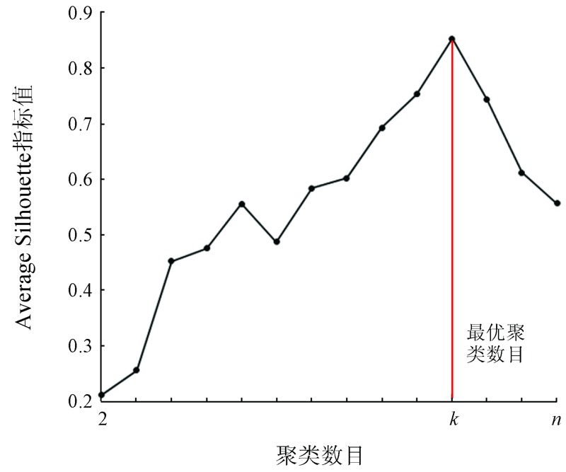
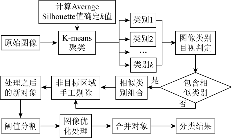
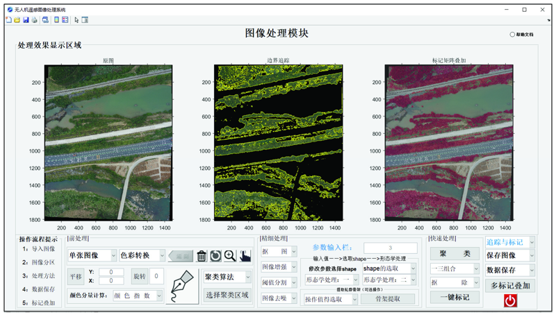
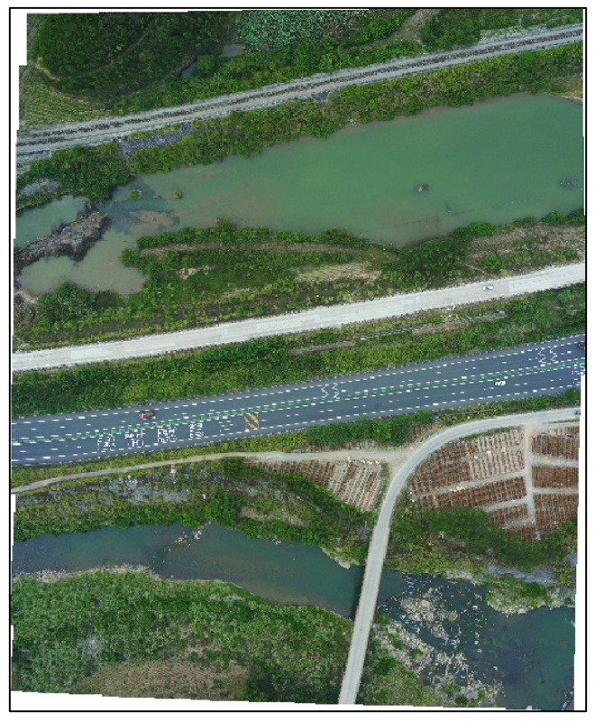
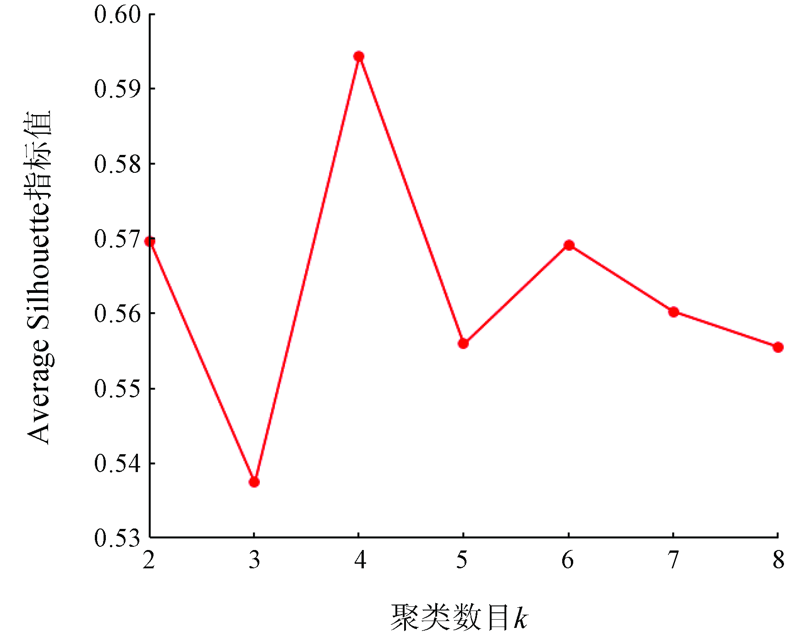
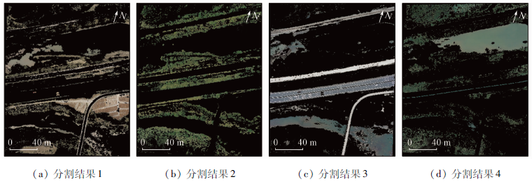
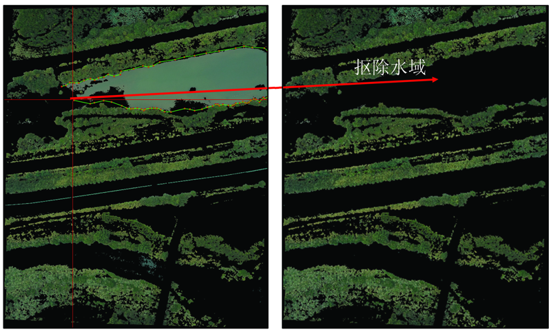
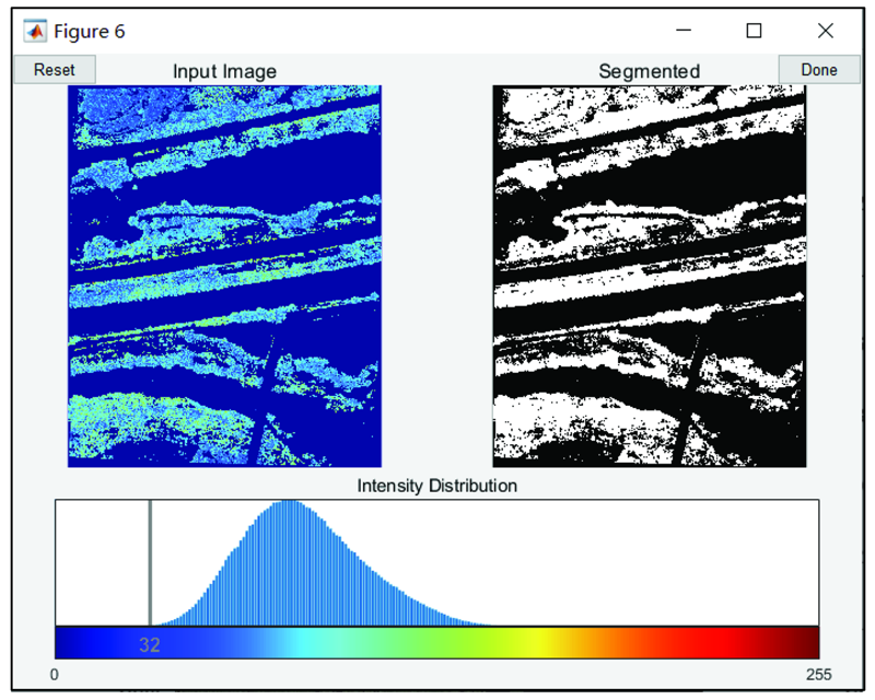
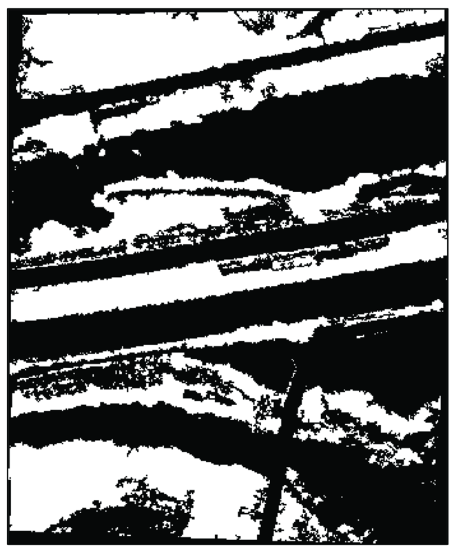
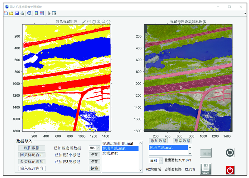
This study proposed a K-means clustering-guided threshold-based approach to classifying the high-resolution remote sensing images obtained using unmanned aerial vehicles (UAVs). The steps of the approach are as follows. First, calculate the average silhouette of the UAV remote sensing image dataset as the optimal number of clusters in the K-means clustering. Then perform K-means clustering on the original images, and manually remove non-target areas in the initial segmentation results. Afterward, perform threshold-based segmentation and image optimization on the new objects obtained to extract objects. Finally, combine all the feature tags obtained to realize the recognition and classification of remote sensing images. The abovementioned processing steps were integrated using the MATLAB/GUI platform. Based on this, a classification processing system of UAV remote sensing images was developed. It can quickly process UAV remote sensing images and achieve semi-automatic interpretation. The accuracy of the classification results was verified, obtaining an overall accuracy of 91.09% and a Kappa coefficient of 0.88. This indicates that the approach proposed in this paper can obtain high-quality segmentation results of UAV remote sensing images.
Colomina I, Molina P. Unmanned aerial systems for photogrammetry and remote sensing:A review[J]. ISPRS Journal of Photogrammetry and Remote Sensing, 2014, 92(6):79-97.
doi: 10.1016/j.isprsjprs.2014.02.013
Liao X H, Xiao Q, Zhang H. UAV remote sensing:Popularization and expand application development trend[J]. Journal of Remote Sensing, 2019, 23(6):1046-1052.
Zhao X T, Hu K, Lu X P, et al. Precise detection method for mine geological disasters using low-altitude photogrammetry based on unmanned aerial vehicle[J]. Science of Surveying and Mapping, 2014, 39(6):49-52,64.
Fu X, Guo J W, Liu X J, et al. Method of earthquake landslide information extraction based on high resolution unmanned aerial vehicle images[J]. Journal of Seismological Research, 2018, 41(2):186-191.
Zhang K, Hei B Q, Li S Y, et al. Complex scene classification of remote sensing images based on CNN[J]. Remote Sensing for Land and Resources, 2018, 30(4):49-55.doi: 10.6046/gtzyyg.2018.04.08.
doi: 10.6046/gtzyyg.2018.04.08
Chen D, Wu S Q, Qu P, et al. Research on decision tree optimization for extracting urban land cover information from high-resolution remote sensing images[J]. Statistics & Decision, 2014, 30(4):55-59.
[7]
宋超峰. 基于机器学习的地物图像分类方法研究[D]. 太原:中北大学, 2018.
Song C F. Research on ground object image classification method based on machine learning[D]. Taiyuan:North University of China, 2018.
[8]
Cheng G, Guo L, Zhao T Y, et al. Automatic landslide detection from remote-sensing imagery using a scene classification method based on BoVW and pLSA[J]. International Journal of Remote Sensing, 2013, 34(1):45-59.
doi: 10.1080/01431161.2012.705443
[9]
Fiorucci F, Cardinal M, Carla R, et al. Seasonal landslide mapping and estimation of landslide mobilization rates using aerial and satellite images[J]. Geomorphology, 2011, 129(1):59-70.
doi: 10.1016/j.geomorph.2011.01.013
Li Y J, Niu M T, Li L H. Research on remote sensing image clustering based on bee colony K-means algorithm[J]. Computer Engineering and Applications, 2019, 55(6):151-159.
[11]
MacQueen J. Some methods for classification and analysis of multivariate observation[C]// Proceedings of the 5th Berkeley Symposium on Mathematical Statistics and Probability. Berkeley: University of California Press, 1967:281-297.
[12]
Hung C H, Chiou H M, Yang W N. Candidate groups search for K-harmonic means data clustering[J]. Applied Mathematical Modelling, 2013, 37(24):10123-10128.
doi: 10.1016/j.apm.2013.05.052
Yang J C, Zhao C. Survey on K-means clustering algorithm[J]. Computer Engineering and Applications, 2019, 55(23):7-14,63.
[14]
Saroj K. Review:Study on simple k mean and modified K mean clustering technique[J]. International Journal of Computer Science Engineering and Technology, 2016, 6(7):279-281.
Wang H X, Jin H J, Wang J L, et al. Optimization approach for multi-scale segmentation of remotely sensed imagery under k-means clustering guidance[J]. Acta Geodaetica et Cartographica Sinica, 2015, 59(5):526-532.
Yang N, Tang C J, Wang Y, et al. Mining evolutionary events from multi-streams based on spectral clustering[J]. Journal of Software, 2010, 21(10):2395-2409.
Liu Q, Wang K L, Rao W X. Non-equal time series clustering algorithm with sliding window STS distance[J]. Journal of Frontiers of Computer Science and Technology, 2015, 9(11):1301-1313.
Yang Y K, Xiao P F, Feng X Z, et al. Comparison and assessment of large-scale land cover datasets in China and adjacent regions[J]. Journal of Remote Sensing, 2014, 18(2):453-475.
 2021, Vol. 33
  ), 王章琼1(