Salinization inversion model based on ENDVI-SI3 characteristic space and risk assessment
ZHANG Siyuan1,2(), YUE Chu1,2, YUAN Guoli2(), YUAN Shuai1, PANG Wenqiang3, LI Jun2
1. Hohhot General Survey of Natural Resources Center, China Geological Survey, Hohhot 010010, China 2. School of Earth Sciences and Resources, China University of Geosciences(Beijing), Beijing 100083, China 3. Bayannur City Modern Agriculture and Animal Husbandry Development Center, Bayannur 015000, China
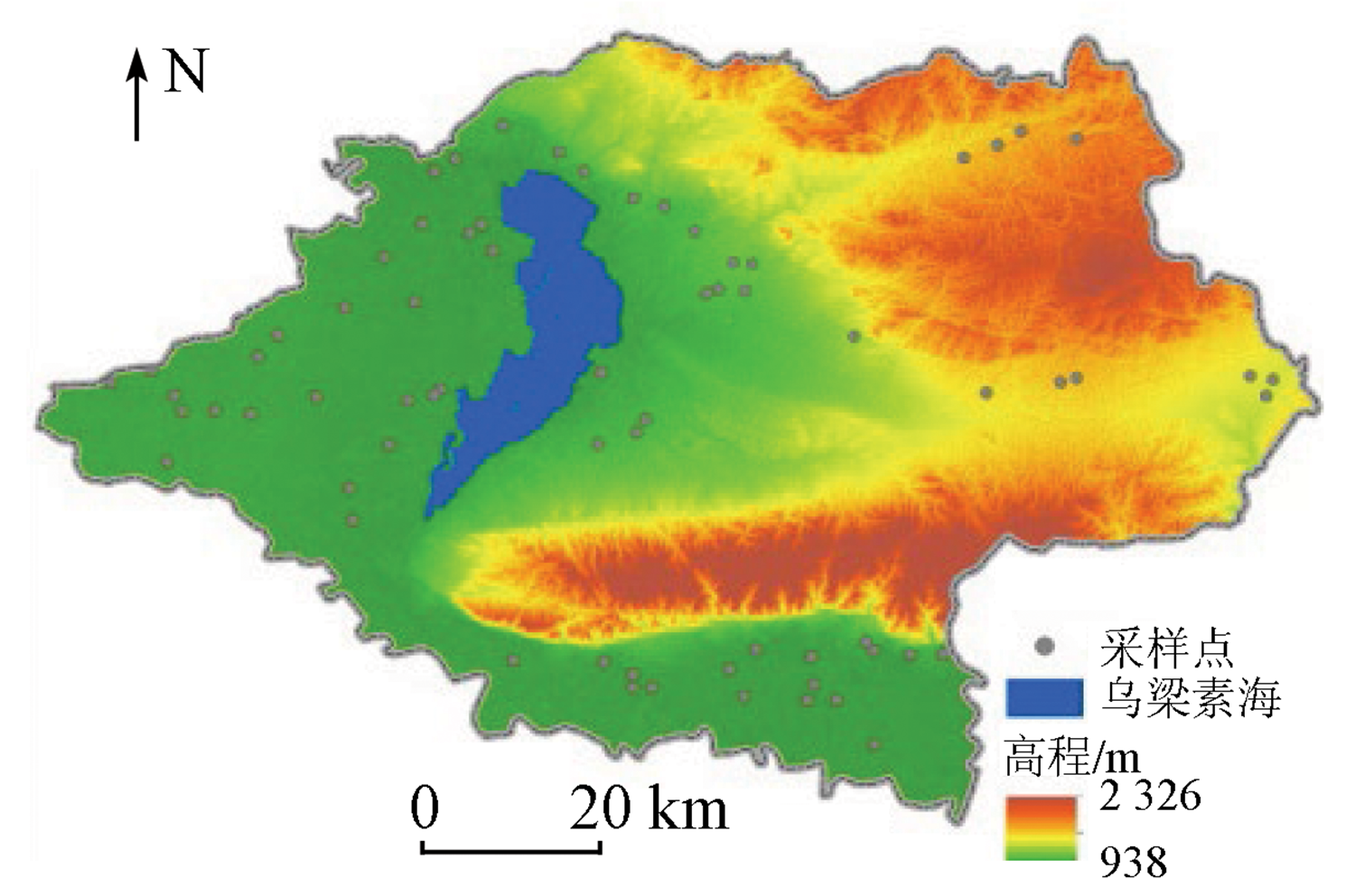
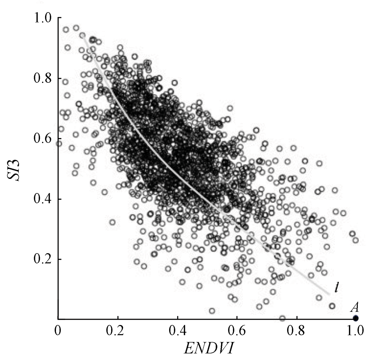
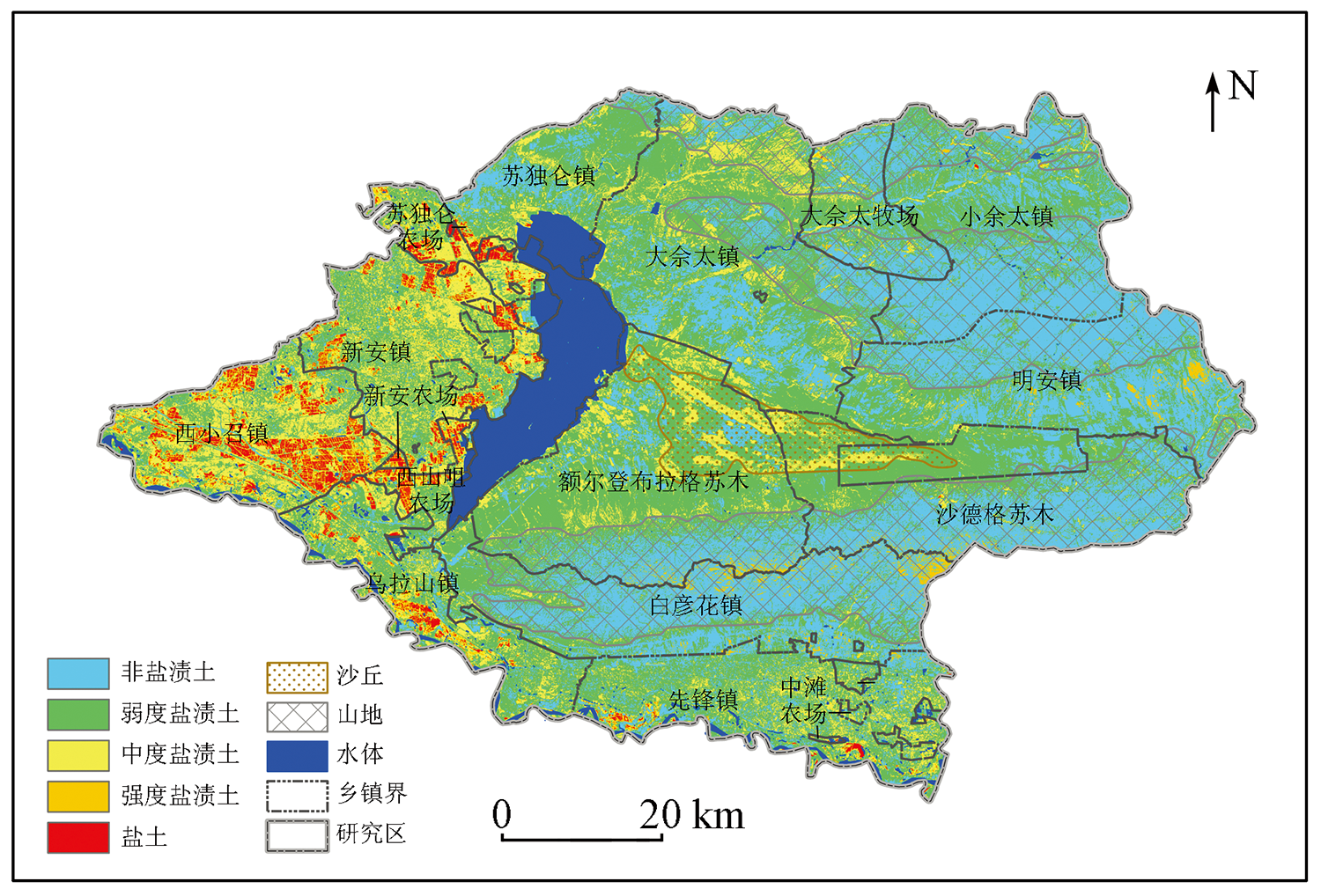
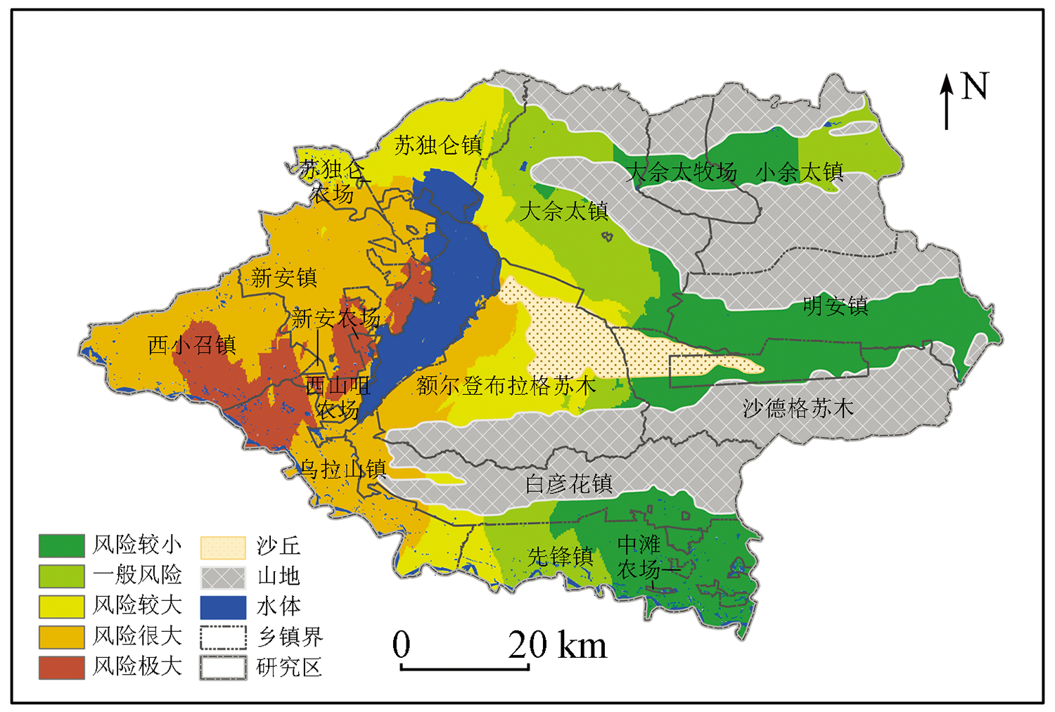
Soil salinization is the most severe environmental risk in arid and semi-arid areas. The remote sensing method that constructs a characteristic space based on characteristic parameters provides an effective and economical tool and technique for the timely monitoring and inversion of soil salinization. Presently, the normalized difference vegetation index (NDVI) and the salinity index (SI) are mainly selected as the characteristic parameters for salinization inversion, while refined analysis and regional applicability are lacking. This study investigated Urad Front Banner in Inner Mongolia based on the Landsat8 OLI data. The ENDVI-SI3 characteristic space was constructed using the enhanced normalized difference vegetation index (ENDVI) that introduced the shortwave infrared band and the salinity index 3 (SI3) with the best inversion effect for semi-arid areas. Accordingly, the improved salinization monitoring index (ISMI) model was built. The results show that the correlation coefficient between ISMI and soil salt content was up to 0.82, and the inversion precision of the ISMI model was higher than that of NDVI, EDNVI, and SI3 (-0.66, -0.70, and 0.75, respectively). Based on the ISMI, this study achieved the quantitative inversion analysis and risk assessment of soil salinization in Urad Front Banner. This study provides an approach for selecting the optimal characteristic parameters of the characteristic space in the salinization inversion of semi-arid areas.
Zhu T Y. Soils-salinity control in irrigation area[M]. Beijing: Agricultural Press, 1992:32-37.
[2]
Kovda A. Loss of productive land due to salinization[J]. Ambio, 1983, 12(2):1-4.
[3]
杨劲松. 中国盐渍土研究的发展历程与展望[J]. 土壤学报, 2008(5):837-845.
Yang J S. Development and prospect of the research on salt-affected soils in China[J]. Acta Pedologica Sinica, 2008(5):837-845.
[4]
Allbed A, Kumar L. Soil salinity mapping and monitoring in arid and semi-arid regions using remote sensing technology:A review[J]. Advances in Remote Sensing, 2013, 2(4):373-385.
doi: 10.4236/ars.2013.24040
[5]
Metternicht G I, Zinck J A. Remote sensing of soil salinity:Potentials and constraints[J]. Remote Sensing of Environment, 2003, 85(1):1-20.
doi: 10.1016/S0034-4257(02)00188-8
Zhao J Q. Remote sensing monitoring method of soil salinization and its application[J]. Rural Economy and Science-Technology, 2018, 29(7):41-42.
[7]
Thiam S, Villamor G B, Faye L C, et al. Monitoring land use and soil salinity changes in coastal landscape:A case study from Senegal[J]. Environmental Monitoring and Assessment, 2021, 193(5): 259-260.
doi: 10.1007/s10661-021-08958-7
Pan X Y, Cui J H, Yang J Y, et al. Ecological risk assessment of salinization in coastal plain based on SDI correction index[J]. Journal of Agricultural Resources and Environment, 2020, 37(5):709-718.
Fan Y G, Zhang W K, Liu J Y. Remote sensing monitoring model of soil salinization in the Yellow River delta zone based on vegetation index-salt index feature space[J]. Shandong Agricultural Sciences, 2016, 48(5):137-141.
Ha X P, Ding J L, Tashpolat T, et al. SI-Albedo space-based remote sensing synthesis index models for monitoring of soil salinization[J]. Acta Pedologica Sinica, 2009, 46(4):698-703.
Wang F, Ding J L, Wu M C. Remote sensing monitoring models of soil salinization based in NDVI-SI feature space[J]. Transactions of the Chinese Society of Agricultural Engineering, 2010, 26(8):168-173,8.
Chen S, Xu B, Jin Y X, et al. Remote sensing monitoring and spatial-temporal characteristics analysis of soil salinization in agricultural area of northern Xinjiang[J]. Scientia Geographica Sinica, 2015, 35(12):1607-1615.
doi: 10.13249/j.cnki.sgs.2015.012.1607
Zhang T Y, Wang L, Wang H, et al. Assessment of soil salinization ecological environment change in the Manas River basin using remote sensing technology[J]. Acta Ecologica Sinica, 2017, 37(9):3009-3018.
Shi H B, Yang S Q, Li R P, et al. Soil water and salt movement and soilsalinization control in Hetao irrigation district:Current state and future prospect[J]. Journal of Irrigation and Drainage, 2020, 39(8):1-17.
Lu J, Zhang X J, Ye P S, et al. Remote sensing monitoring of salinization in Hetao irrigation district based on SI-MSAVI feature space[J]. Remote Sensing for Land and Resources, 2020, 32(1):169-175.doi: 10.6046/gtzyyg.2020.01.23.
doi: 10.6046/gtzyyg.2020.01.23
Sun G J, Sun T. Study on modern oasis agricultural influencing factors and its countermeasures in Wulate County[J]. Areal Research and Development, 2011, 30(6):136-139.
Sun G J. Evaluation of eco-environment fragilily with BP artificial neural networks in Wulate Country,Inner Mongolia,China[D]. Lanzhou: Northwest Normal University, 2009.
Wang X Q, Gao Q Z, Lu Q. Effective use of water resources and salinity and waterlogging control in the Hetao irrigation area of Inner Mongolia[J]. Journal of Arid Land Resources and Environment, 2005(6):120-125.
Li C, Wen T S, Zhang F R, et al. Method for remote sensing survey and mapping of soil types and subtypes in semi-arid sand region[J]. Transactions of the Chinese Society of Agricultural Engineering, 2018, 34(6):189-196.
[20]
Weiss E, Marsh S E, Pfirman E S. Application of NOAA-AVHRR NDVI time-series data to assess changes in Saudi Arabia’s rangelands[J]. International Journal of Remote Sensing, 2001, 22(6): 1005-1028.
doi: 10.1080/014311601300074540
[21]
Tilley D R, Ahmed M, Son J H, et al. Hyperspectral reflectance response of freshwater macrophytes to salinity in a brackish subtropical marsh[J]. Journal of Environmental Quality, 2007, 36(3): 780-789.
pmid: 17412913
Sun Y. Inversion of the degree of soil salinization based on spectra of soil and vegetation in northern Yinchuan Plain of Ningxia[D]. Yinchuan: Ningxia University, 2020.
Chen H Y, Zhao G X, Chen J C, et al. Remote sensing inversion of saline soil salinity based on modified vegetation index in estuary area of Yellow River[J]. Transactions of the Chinese Society of Agricultural Engineering, 2015, 31(5):107-112.
[24]
Allbed A, Kumar L, Aldakheel Y Y. Assessing soil salinity using soil salinity and vegetation indices derived from IKONOS high-spatial resolution imageries: Applications in a date palm dominated region[J]. Geoderma, 2014, 230:1-8.
[25]
Khan N M, Rastoskuev V V, Sato Y, et al. Assessment of hydrosaline land degradation by using a simple approach of remote sensing indicators[J]. Agricultural Water Management, 2005, 77: 96-109.
doi: 10.1016/j.agwat.2004.09.038
[26]
Bannari A, Guedon A M, El-Harti A, et al. Characterization of slightly and moderately saline and sodic soils in irrigated agricultural land using simulated data of advanced land imaging (EO-1) sensor[J]. Communications in Soil Science and Plant Analysis, 2009, 39: 2795-2811.
doi: 10.1080/00103620802432717
Wang S, Ding J L, Wang L, et al. Remote sensing monitoring of soil salinization based on surface spectral modeling[J]. Arid Land Geo-graphy, 2016, 39(1):190-198.
Zhang J H, Sun Y, Jia K L, et al. Spectral characteristics and salinization information prediction of different soil salt crusts[J]. Transactions of the Chinese Society for Agricultural Machinery, 2018, 49(12):325-333,370.
[29]
Al-Khakani E T, Yousif S R. An assessment of soil salinity and vegetation cover changes for a part of An-Najaf governorate using remote sensing data[J]. Journal of Physics: Conference Series, 2019, 1234: 012023.
doi: 10.1088/1742-6596/1234/1/012023
[30]
Verstraete M M, Pinty B. Designing optimal spectral indexes for remote sensing applications[J]. IEEE Transactions on Geoscience and Remote Sensing, 1996, 4(5):1254-1265.
Li Z Z, Li W D, Shi H H, et al. Gray model for ecological risk assessment and its application in salinization oasis agroecosystem[J]. Journal of Desert Research, 2002(6):95-100.
Li X Y, Cui J Q, Shi H B, et al. Analysis of soil salinization risk and groundwater environment based on indicator Kriging[J]. Transactions of the Chinese Society for Agricultural Machinery, 2021, 52(8):297-306.
Li D S, Yang J S, Yao R J. Application of ecological risk analysis to soil salinization risk assessment of coastal tidal flat in north Jiangsu Province[J]. Acta Pedologica Sinica, 2010, 47(5):857-864.
 2022, Vol. 34
  ), 岳楚1,2, 袁国礼2(