Extracting information about mining subsidence by combining an improved U-Net model and D-InSAR
LIN Jiahui1,2,3(), LIU Guang1,2,3, FAN Jinghui4(), ZHAO Hongli4, BAI Shibiao5,6, PAN Hongyu1,2,3
1. Key Laboratory of Digital Earth Science, Aerospace Information Research Institute, Chinese Academy of Sciences, Beijing 100094, China 2. International Research Center of Big Data for Sustainable Development Goals, Beijing 100094, China 3. University of Chinese Academy of Sciences, Beijing 100049, China 4. China Aero Geophysical Survey and Remote Sensing Center for Natural Resources, Beijing 100083, China 5. College of Marine Sciences and Engineering, Nanjing Normal University, Nanjing 210023, China 6. Key Laboratory of Mountain Hazards and Earth Surface Processes, Institute of Mountain Hazards and Environment, Chinese Academy of Sciences, Chengdu 610041, China
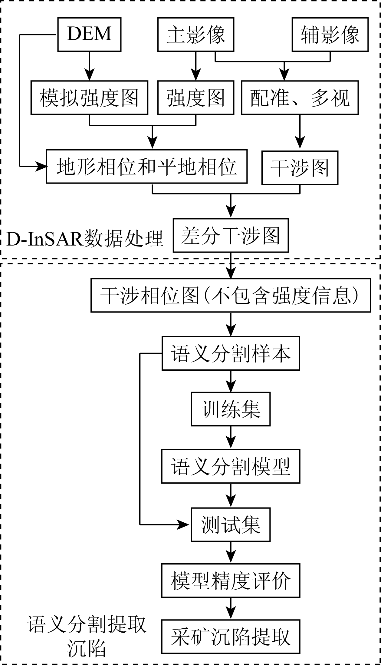
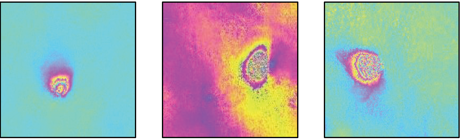
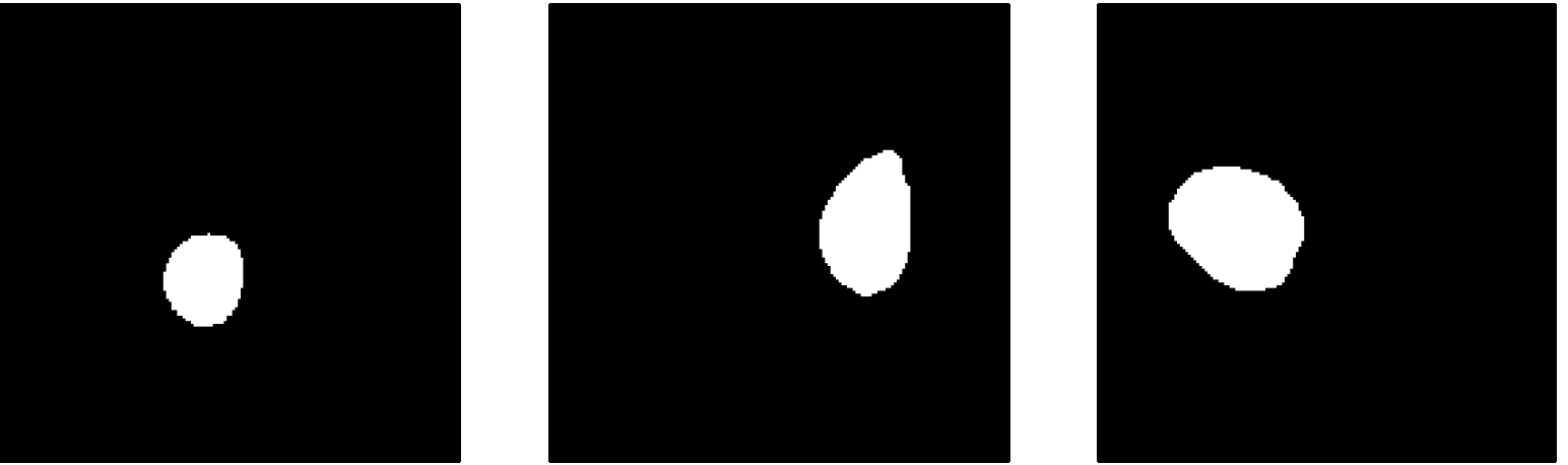
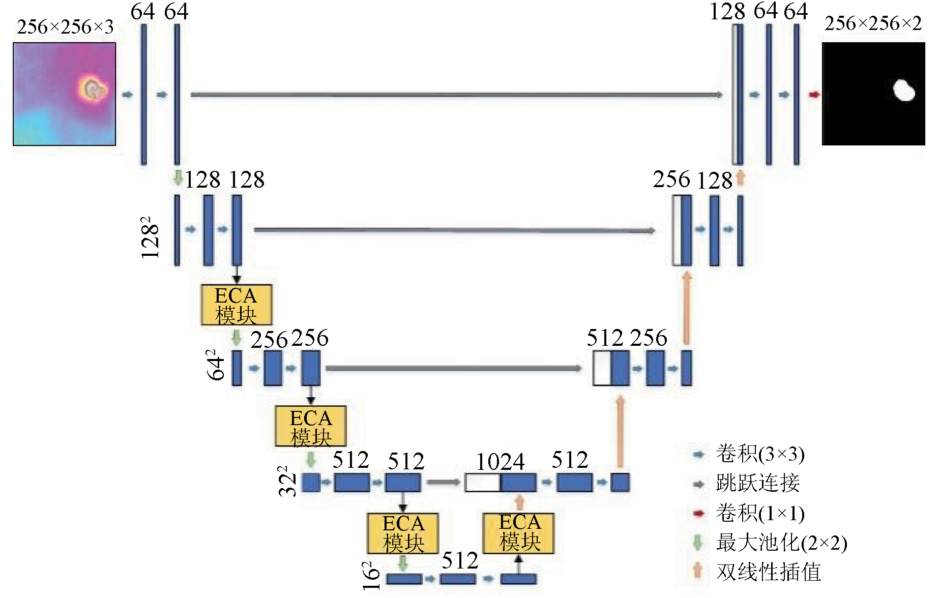
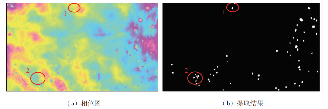
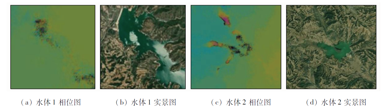
Surface subsidence caused by the exploitation of mineral resources must be considered during the development and utilization of land and space in mining areas. Furthermore, it serves as a significant indication of underground areas subjected to illicit mining. The exploitation of mineral resources is generally conducted in widespread, uneven, and dispersed areas, making it necessary to quickly and accurately identify and extract the spatial distribution of mining subsidence in large areas. This study determined the multitemporal differential interferometric phase diagram of mining areas using the differential interferometric synthetic aperture Radar (D-InSAR) technique. Furthermore, it trained networks for the intelligent identification of mining subsidence by employing deep-learning FCN-8s, PSPNet, Deeplabv3, and U-Net models. The results show that the U-Net model enjoys a high detection accuracy and a short detection time. To improve the semantic segmentation and extraction accuracy of information about mining subsidence, this study introduced the efficient channel attention (ECA) module into the conventional U-Net model during the training. Compared with the conventional model, the improved U-Net model increased the intersection over union (IOU) corresponding to mining subsidence by 2.54 percentage points.
基金资助:国家重点研发计划项目“高亚洲和北极积雪-冰川与地质灾害监测技术及示范应用”(2021YFE0116800);中欧龙计划5期合作项目“Integration of multisource remote sensing data to detect and monitoring large and rapid landslides and use of artificial intelligence for cultural heritage preservation”(56796);可持续发展大数据国际研究中心创新研究计划(CBAS2022IRP02);国家自然科学基金项目“青藏高原露天煤矿排土场地形-土壤-植被响应机理及地貌重塑研究”(41977415)
林佳惠, 刘广, 范景辉, 赵红丽, 白世彪, 潘宏宇. 联合改进U-Net模型和D-InSAR技术采矿沉陷提取方法[J]. 自然资源遥感, 2023, 35(3): 145-152.
LIN Jiahui, LIU Guang, FAN Jinghui, ZHAO Hongli, BAI Shibiao, PAN Hongyu. Extracting information about mining subsidence by combining an improved U-Net model and D-InSAR. Remote Sensing for Natural Resources, 2023, 35(3): 145-152.
Hu Z Q, Long J H, Zhang R Y, et al. Damage characteristics and reclamation planning of coal mining subsidence land in old mining areas in northeast China[J]. Transactions of the Chinese Society of Agricultural Engineering, 2017, 33(5):238-247.
Liu H, Zhu X J, Cheng H, et al. Key technology of human environment and ecological reconstruction in high submersible level coal mining subsidence area:A case study from Lyujin Lake,Huaibei[J]. Journal of China Coal Society, 2021, 46(12):4021-4032.
[3]
Ignacy D. Comprehensive method of assessing the flood threat of artificially drained mine subsidence areas for identification and sustainable repair of mining damage to the aquatic environment[J]. Water Resources and Industry, 2021, 26:100153.
doi: 10.1016/j.wri.2021.100153
Li J M, Yu J H, Zhang W Z. Spatial distribution and governance of coal-mine subsidence in China[J]. Journal of Natural Resources, 2019, 34(4):867-880.
doi: 10.31497/zrzyxb.20190415
[5]
Donnelly L J, De La Cruz H, Asmar I. The monitoring and prediction of mining subsidence in the Amaga,Angelopolis,Venecia and Bolombolo Regions,Antioquia,Colombia[J]. Engineering Geology, 2001, 59(1-2):103-114.
doi: 10.1016/S0013-7952(00)00068-5
[6]
Liu C, Zhou F, Gao J X, et al. Some problems of GPS RTK technique application to mining subsidence monitoring[J]. International Journal of Mining Science and Technology, 2012, 22(2):223-228.
doi: 10.1016/j.ijmst.2012.03.001
[7]
Wang Z, Wang Z, Liu G, et al. Monitoring the coal mining subsidence in Jibei mine area using D-InSAR technique[C]// 2009 International Conference on Information Engineering and Computer Science.IEEE, 2009:1-4.
Liu G, Guo H D, Ramon H, et al. The application of InSAR technology to mining area subsidence monitoring[J]. Remote Sensing for Land and Resources, 2008, 20(2):51-55.doi:10.6046/gtzyyg.2008.02.13.
doi: 10.6046/gtzyyg.2008.02.13
[9]
Guéguen Y, Deffontaines B, Fruneau B, et al. Monitoring residual mining subsidence of Nord/Pas-de-Calais coal basin from differential and persistent scatterer interferometry (Northern France)[J]. Journal of Applied Geophysics, 2009, 69(1):24-34.
doi: 10.1016/j.jappgeo.2009.02.008
[10]
Carnec C, Massonnet D, King C. Two examples of the use of SAR interferometry on displacement fields of small spatial extent[J]. Geophysical Research Letters, 1996, 23(24):3579-3582.
doi: 10.1029/96GL03042
[11]
Ge L, Chang H C, Rizos C. Mine subsidence monitoring using multi-source satellite SAR images[J]. Photogrammetric Engineering and Remote Sensing, 2007, 73(3):1742-1745.
[12]
Wang Z, Zhang J, Liu G. Measuring land subsidence by PALSAR interferometry in Yanzhou coal mine area[C]// International Conference on Image Processing and Pattern Recognition in Industrial Engineering.SPIE, 2010, 7820:815-822.
Bai Z C, Wang B C, Jin G W, et al. Applicability analysis of ground deformation monitoring in mining area by Sentinel-1A data[J]. Remote Sensing for Land and Resources, 2019, 31(2):210-217.doi: 10.6046/gtzyyg.2019.02.29.
doi: 10.6046/gtzyyg.2019.02.29
Zhang T, Xie S, Huang B, et al. Detection of active landslides in central Maoxian County using Sentinel-1 and ALOS-2 data[J]. Remote Sensing for Land and Resources, 2021, 33(2):213-219.doi:10.6046/gtzyyg.2020206.
doi: 10.6046/gtzyyg.2020206
[15]
He Q, Zhang Y, Wu H, et al. Mining subsidence monitoring with modified time-series SAR interferometry method based on the multi-level processing strategy[J]. IEEE Access, 2021, 9:106039-106048.
doi: 10.1109/ACCESS.2021.3099633
[16]
Xing X M, Zhu J J, Wang Y Z, et al. Time series ground subsidence inversion in mining area based on CRInSAR and PSInSAR integration[J]. Journal of Central South University, 2013, 20(9):2498-2509.
doi: 10.1007/s11771-013-1762-x
[17]
Lesniak A, Porzycka S, Graniczny M. Subsidence analysis in mining area of Dabrowskie coal basin using PSInSAR technique[C]// 13th European Meeting of Environmental and Engineering Geophysics.European Association of Geoscientists and Engineers, 2007.
[18]
Han S, Zhao B, Bai Y, et al. Mining subsidence research based on SBAS-InSAR in Yaojie coal mine[J]. Mine Surveying, 2019, 47:1-5.
Li M M, Fan X T, Chen C, et al. Monitoring and interpretation of land subsidence in mining areas in Xuzhou City during 2016—2018[J]. Remote Sensing for Natural Resources, 2021, 33(4):43-54.doi:10.6046/zrzyyg.2020137.
doi: 10.6046/zrzyyg.2020137
Shi M, Gong H L, Chen B B, et al. Monitoring of land subsidence in Beijing - Tianjin - Hebei plain during 2016—2018 based on InSAR and Sentinel-1A data[J]. Remote Sensing for Natural Resources, 2021, 33(4):55-63.doi:10.6046/zrzyyg.2020341.
doi: 10.6046/zrzyyg.2020341
Liu J L, Guo H D, Song R, et al. The application of multi-mode Radar to mining area subsidence monitoring[J]. Remote Sensing Technology and Application, 2012, 27(4):584-590.
[22]
Bała J, Porzycka-Strzelczyk S, Strzelczyk J. Subsidence troughs detection for SAR images:Preliminary results[J]. 15th International Multidisciplinary Scientific GeoConferences(SGEM), 2015:18-24.
[23]
Klimczak M, Bała J. Application of the Hough transform for subsidence troughs detection in SAR images[J]. 17th International Multidisciplinary Scientific GeoConference(SGEM), 2017:819-826.
[24]
Bała J, Dwornik M, Franczyk A J S. Automatic subsidence troughs detection in SAR interferograms using circlet transform[J]. Sensors, 2021, 21(5):1706.
doi: 10.3390/s21051706
[25]
Porzycka-Strzelczyk S, Rotter P, Strzelczyk J. Automatic detection of subsidence troughs in SAR interferograms based on circular Gabor filters[J]. IEEE Geoscience and Remote Sensing Letters, 2018, 15(6):873-876.
doi: 10.1109/LGRS.2018.2815782
Zhang Y. Monitoring and identification of subsidence area in Datong coalfield based on InSAR technology[D]. Beijing: China University of Geoscience (Beijing), 2020.
[27]
Wu Z, Zhang H, Wang Y, et al. A deep learning based method for local subsidence detection and InSAR phase unwrapping:Application to mining deformation monitoring[C]// 2020 IEEE International Geoscience and Remote Sensing Symposium.IEEE, 2020:20-23.
[28]
Anantrasirichai N, Biggs J, Kelevitz K, et al. Detecting ground deformation in the built environment using sparse satellite InSAR data with a convolutional neural network[J]. IEEE Transactions on Geo-science and Remote Sensing, 2020, 59(4):2940-2950.
doi: 10.1109/TGRS.2020.3018315
[29]
Valade S, Ley A, Massimetti F, et al. Towards global volcano monitoring using multisensor sentinel missions and artificial intelligence:The MOUNTS monitoring system[J]. Remote Sensing, 2019, 11(13):1528.
doi: 10.3390/rs11131528
[30]
Anantrasirichai N, Biggs J, Albino F, et al. A deep learning approach to detecting volcano deformation from satellite imagery using synthetic datasets[J]. Remote Sensing of Environment, 2019, 230:111179.
doi: 10.1016/j.rse.2019.04.032
[31]
Anantrasirichai N, Biggs J, Albino F, et al. Application of machine learning to classification of volcanic deformation in routinely generated InSAR data[J]. Journal of Geophysical Research:Solid Earth, 2018, 123(8):6592-6606.
doi: 10.1029/2018JB015911
[32]
Wu Z, Zhang H, Wang Y, et al. A deep learning based method for local subsidence detection and InSAR phase unwrapping:Application to mining deformation monitoring[C]// 2020 IEEE International Geoscience and Remote Sensing Symposium.IEEE, 2020:20-23.
[33]
Long J, Shelhamer E, Darrell T. Fully convolutional networks for semantic segmentation[C]// Proceedings of the IEEE Conference on Computer Vision and Pattern Recognition, 2015:3431-3440.
[34]
Zhao H, Shi J, Qi X, et al. Pyramid scene parsing network[C]// Proceedings of the IEEE Conference on Computer Vision and Pattern Recognition, 2017:2881-2890.
[35]
Chen L C, Papandreou G, Schroff F, et al. Rethinking atrous convolution for semantic image segmentation[J/OL]. arXiv, 2017(2017-12-5). http://arxio.org/pdf/1706.05587.pdf.
[36]
Ronneberger O, Fischer P, Brox T. U-net:Convolutional networks for biomedical image segmentation[C]// International Conference on Medical Image Computing and Computer-Assisted Intervention.Springer,Cham, 2015:234-241.
[37]
Wang Q, Wu B, Zhu P, et al. ECA-Net:Efficient channel attention for deep convolutional neural networks[C]// 2020 IEEE/CVF Conference on Computer Vision and Pattern Recognition (CVPR).IEEE, 2020:11531-11539.
[38]
Xu Z, Wu C, Zheng E, et al. Semantic segmentation of buildings in remote sensing images based on dense residual learning and channel adaption[C]// 2019 4th International Conference on Electromechanical Control Technology and Transportation (ICECTT).IEEE, 2019:117-123.
[39]
Chen L C, Zhu Y, Papandreou G, et al. Encoder-decoder with atrous separable convolution for semantic image segmentation[C]// Proceedings of the European Conference on Computer Vision (ECCV), 2018:801-818.
[40]
Simonyan K, Zisserman A. Very deep convolutional networks for large-scale image recognition.[C]// 3rd International Conference on Learning Representations (ICLR), 2015:1-14.
[41]
He K, Zhang X, Ren S, et al. Deep residual learning for image reco-gnition[C]// Proceedings of the IEEE Conference on Computer Vision and Pattern Recognition, 2016:770-778.
 2023, Vol. 35
  ), 刘广1,2,3, 范景辉4(