A performance evaluation method for semantic segmentation models of remote sensing images considering surface features
LIU Li1,2(), DONG Xianmin1,2(), LIU Juan1
1. The Third Geographical Information Mapping Institute of Natural Resources Ministry, Chengdu 610100, China 2. Key Laboratory on Digital Mapping and Land Information Application, Natural Resources Ministry, Chengdu 610100, China
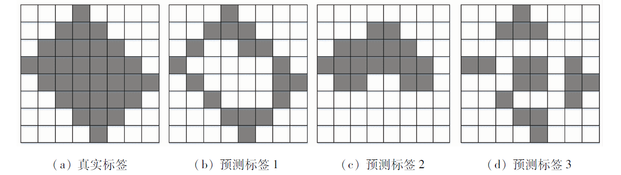
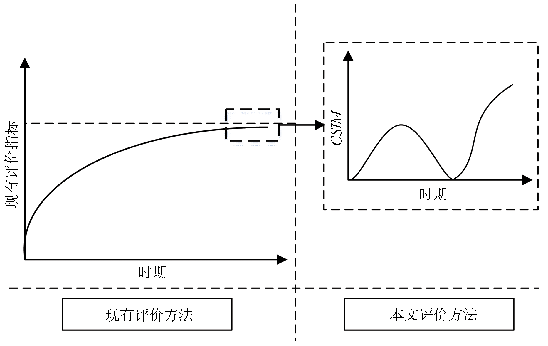
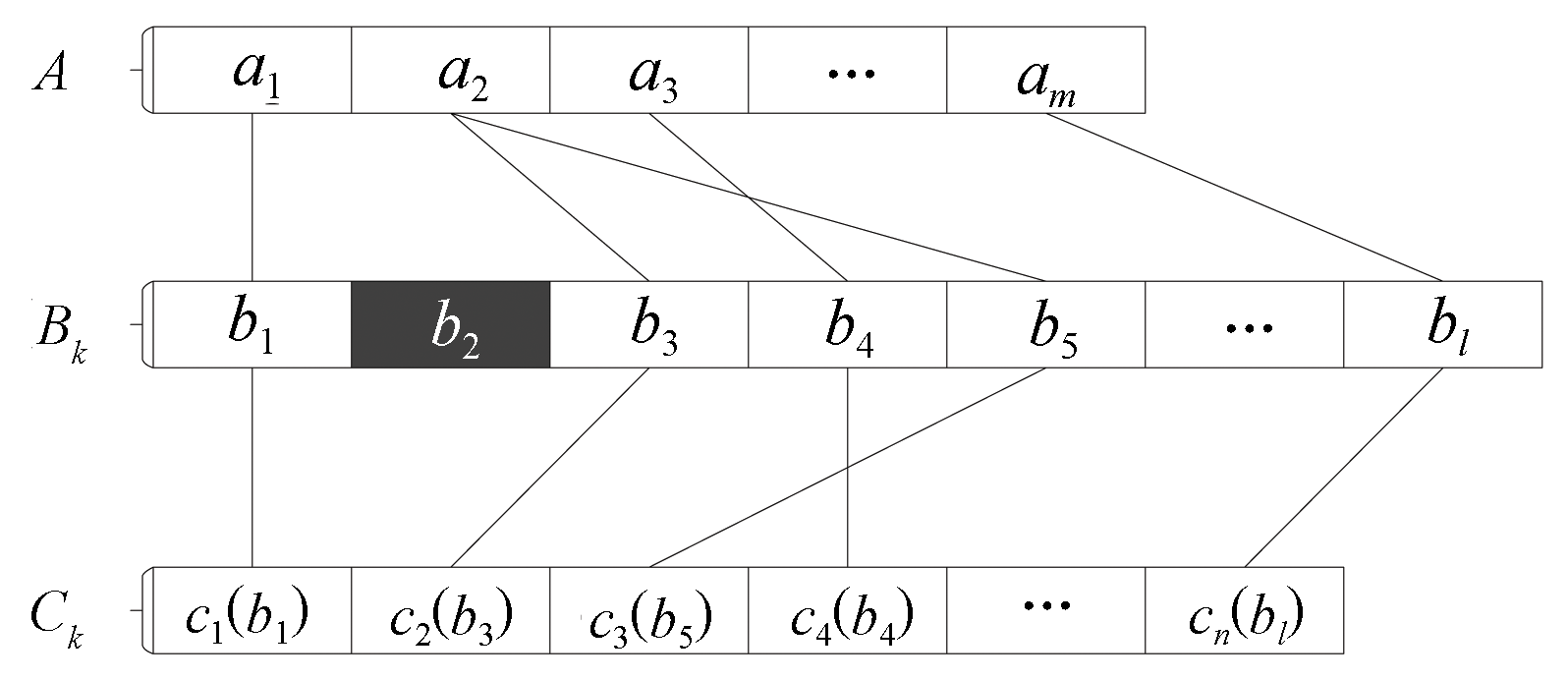
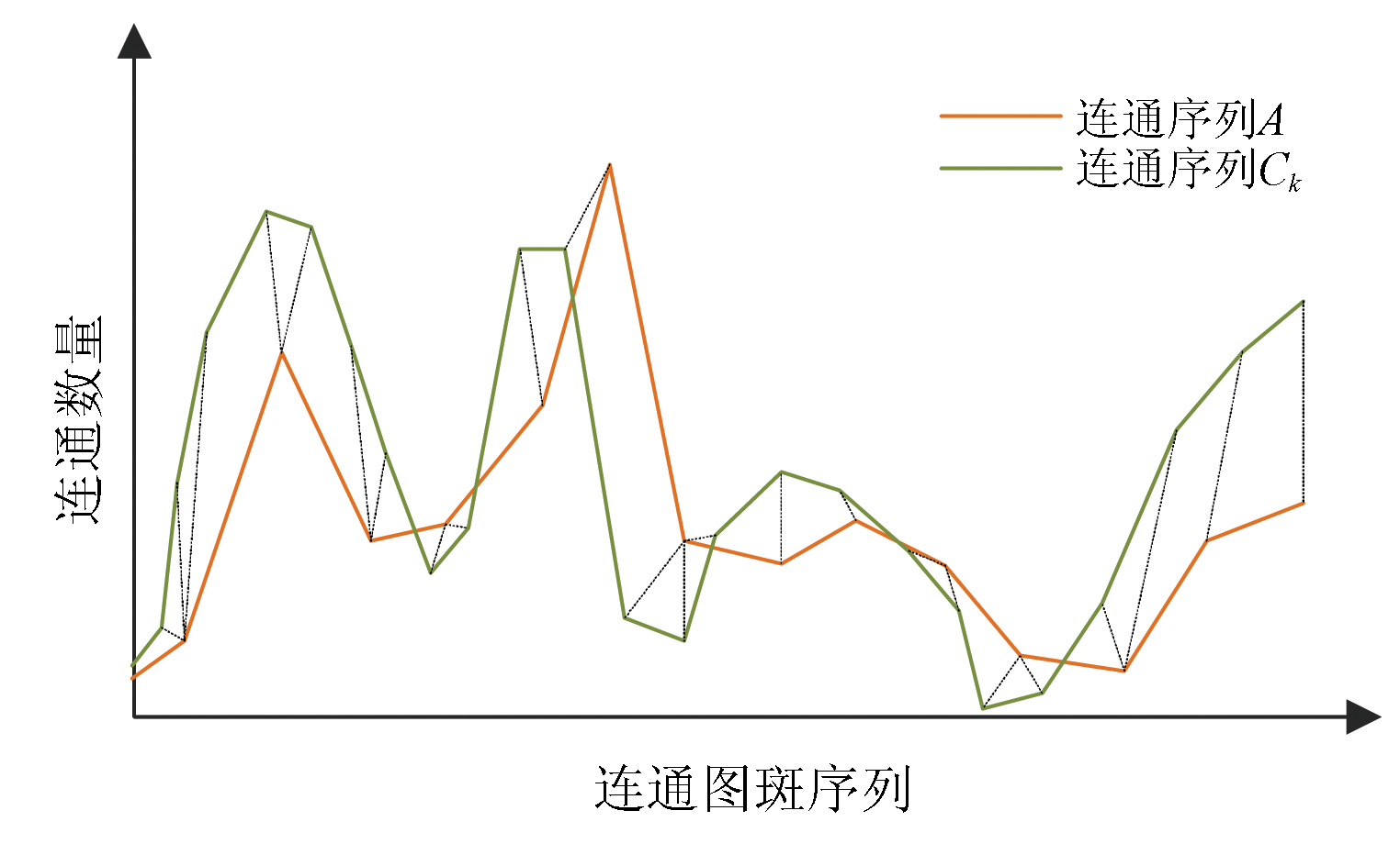
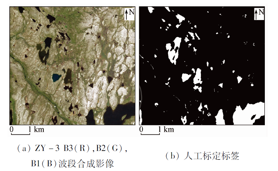
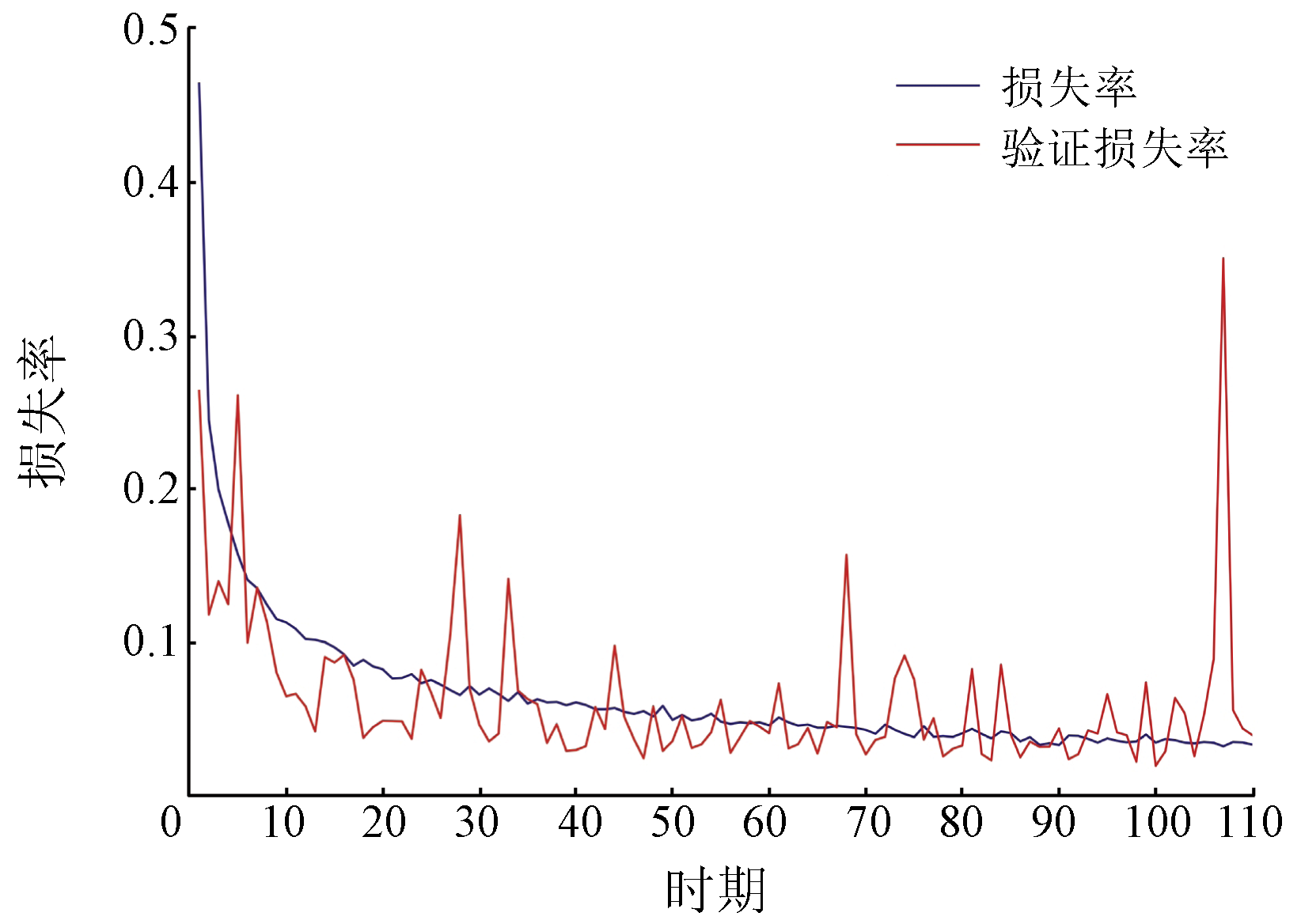
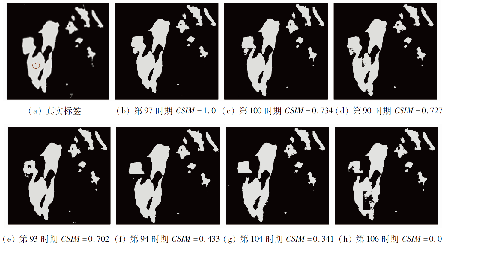
Deep semantic segmentation has been widely applied in land monitoring and interpretation based on remote sensing images. However, existing quality evaluation methods cannot reflect the preserved spatial geometric features of semantic segmentation results. Based on the practical demand for remote sensing image interpretation, surveying, and mapping, this study proposed a method for the performance evaluation of semantic segmentation models for remote sensing images considering geoscience features: the connectivity similarity index (CSIM). From the perspective of the connectivity similarity of surface feature spots in remote sensing images, the CSIM method embedded the surface features into the performance evaluation system of semantic segmentation models. The CSIM method allows for quantitatively evaluating the connectivity similarity of spots between the semantic segmentation results of remote sensing images and the actual sample labels, thus accurately describing the preserved spot integrity in the predicted classification results. Therefore, the CSIM method can objectively determine the applicability of a pre-training model to remote sensing image interpretation in surveying and mapping production. As substantiated by a lot of practice, the CSIM method can monitor and control the model training in real time, effectively guide the selection of the optimal pre-training model, and accurately evaluate the quality of remote sensing image interpretation results considering geoscience features. Therefore, the CSIM method is critical for deep-learning-enabled remote sensing image interpretation, surveying, and mapping.
Gong J Y, Xu Y, Hu X Y, et al. Status analysis and research of sample database for intelligent interpretation of remote sensing image[J]. Acta Geodaetica et Cartographica Sinica, 2021, 50(8):1013-1022.
doi: 10.11947/j.AGCS.2021.20210085
[2]
Rawat W, Wang Z H. Deep convolutional neural networks for image classifycation:A comprehensive review[J]. Neural Computation, 2017, 29(9):2352-2449.
doi: 10.1162/neco_a_00990
[3]
Yuan Q Q, Shen H F, Li T W, et al. Deep learning in environmental remote sensing:Achievements and challenges[J]. Remote Sensing of Environment, 2020, 241:111716.
doi: 10.1016/j.rse.2020.111716
[4]
Zhang L P, Zhang L F, Du B. Deep learning for remote sensing data:A technical tutorial on the state of the art[J]. IEEE Geoscience and Remote Sensing Magazine, 2016, 4(2):22-40.
doi: 10.1109/MGRS.2016.2540798
Hong L, Feng Y F, Peng S Y, et al. Classification of high spatial resolution remote sensing imagery based on object-oriented multiscale weighted sparse representation[J]. Acta Geodaetica et Cartographica Sinica, 2022, 51(2):224-237.
[6]
Zhang P L, Lyu Z Y, Shi W Z. Object-based spatial feature for classification of very high resolution remote sensing images[J]. IEEE Geoscience and Remote Sensing Letters, 2013, 10(6):1572-1576.
doi: 10.1109/LGRS.2013.2262132
[7]
段嘉鑫. 基于上下文信息的图像分割结果质量评价方法研究[D]. 成都: 电子科技大学, 2021.
Duan J X. Research on evaluation method of image segmentation results quality based on context information[D]. Chengdu: University of Electronic Science and Technology, 2021.
Dang Y. Study on automatic evaluation method of land cover classification based on convolutional neural network[D]. Xuzhou: University of Mining and Technology of China, 2018.
Zheng M G, Cai Q G, Qin M Z, et al. A new approach to accuracy assessment of classifications of remotely sensed data[J]. Journal of Remote Sensing, 2006, 10(1):39-48.
[10]
欧阳松. 地学知识嵌入的遥感影像深度语义分割方法研究[D]. 武汉: 武汉大学, 2021.
Ouyang S. The methodology research on geographic knowledge-guided deep semantic segmentation of remote sensing imagery[D]. Wuhan: Wuhan University, 2021.
Tao C, Yin Z W, Zhu Q, et al. Remote sensing image intelligent interpretation:From supervised learning to self-supervised learning[J]. Acta Geodaetica et Cartographica Sinica, 2021, 50(8):1122-1134.
Gong J Y. Chances and challenges for development of surveying and remote sensing in the age of artificial intelligence[J]. Geomatics and Information Science of Wuhan University, 2018, 43(12):1788-1796.
Ye L H, Wang L, Zhang W W, et al. Deep metric learning method for high resolution remote sensing image scene classification[J]. Acta Geodaetica et Cartographica Sinica, 2019, 48(6):698-707.
doi: 10.11947/j.AGCS.2019.20180434
Cao Y D, Liu H Y. Cao X, et al. Overview of image quality assessment method based on deep learning[J]. Computer Engineering and Applications, 2021, 57(23):27-36.
doi: 10.3778/j.issn.1002-8331.2106-0228
Qian X L, Li J, Cheng G, et al. Evaluation of the effect of feature extraction strategy on the performance of high-resolution remote sensing image scene classification[J]. Journal of Remote Sensing, 2018, 22(5):758-776.
Li L, Yu S S. Image quality evaluation method based on deep learning model[J]. Journal of Huazhong University of Science and Technology(Natural Science Edition), 2016, 44(12):70-75.
 2023, Vol. 35
  ), 董先敏1,2(