Pansharpening algorithm of remote sensing images based on NSCT and PCNN
XU Xinyu1(), LI Xiaojun1,2,3(), ZHAO Heting1, GAI Junfei1
1. Faculty of Geomatics, Lanzhou Jiaotong University, Lanzhou 730070, China 2. National-Local Joint Engineering Research Center of Technologies and Applications for National Geographic State Monitoring, Lanzhou 730070, China 3. Gansu Provincial Engineering Laboratory for National Geographic State Monitoring, Lanzhou 730070, China
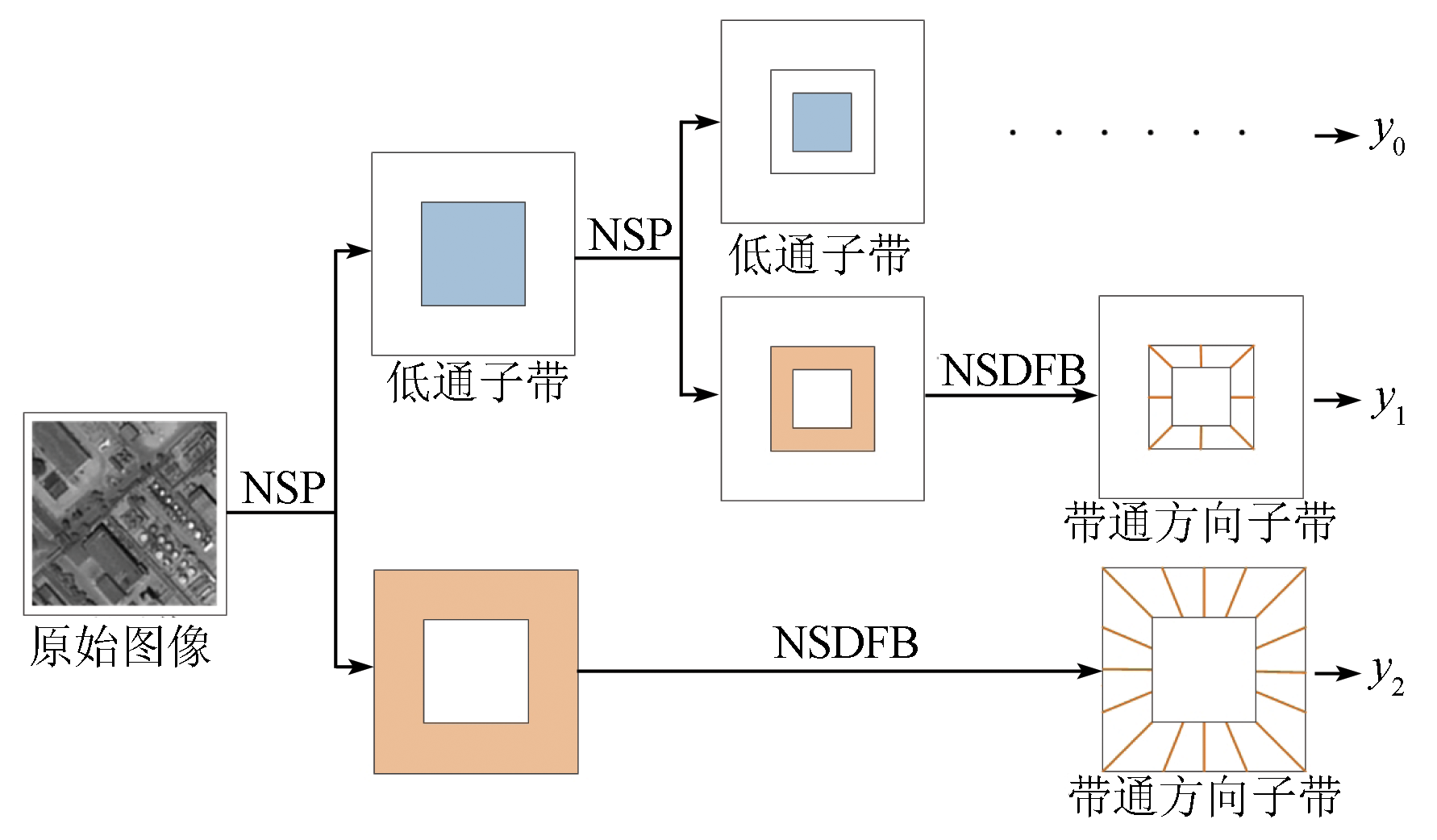
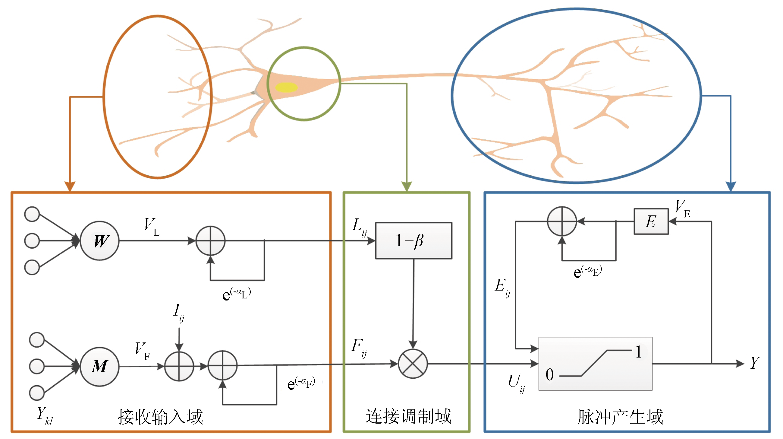
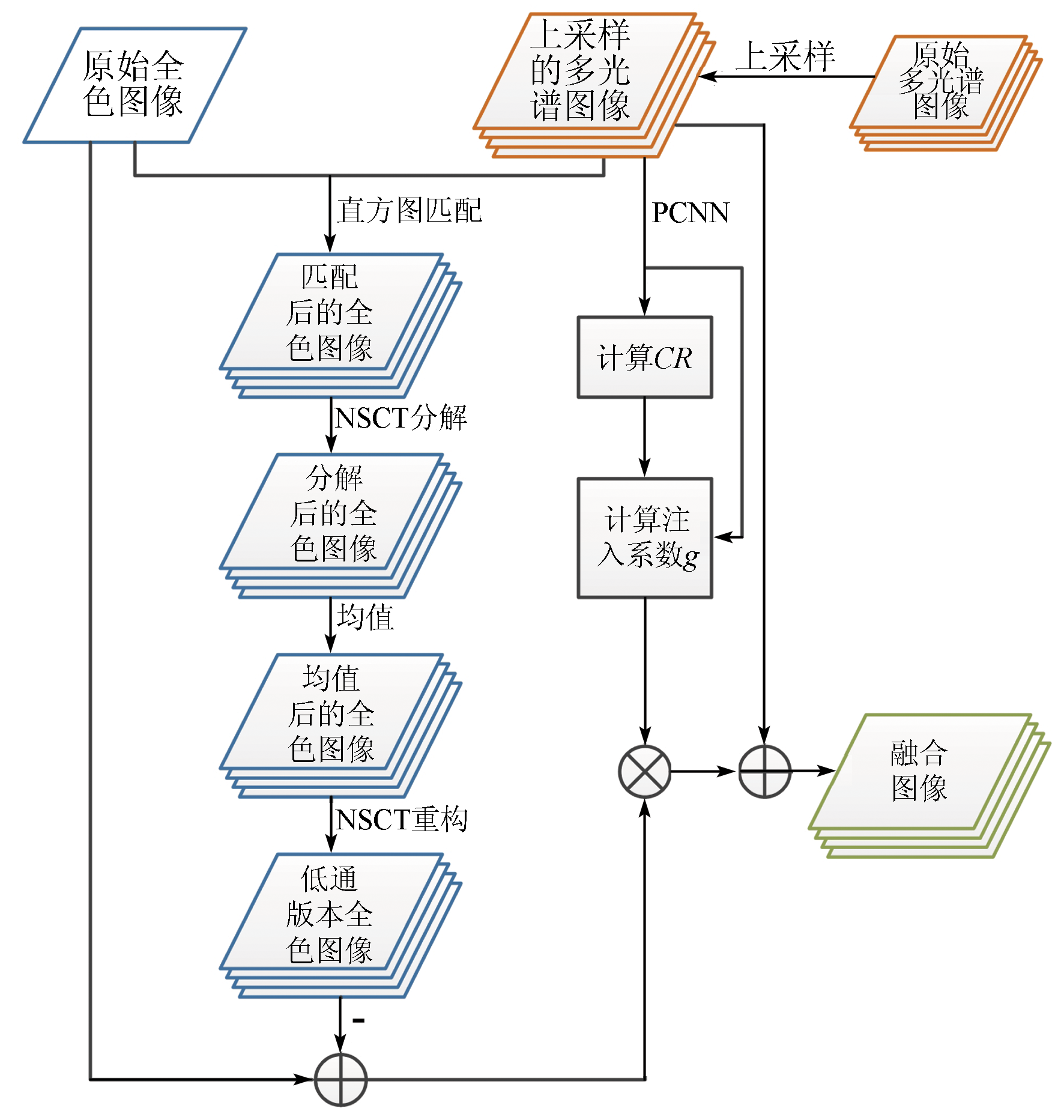
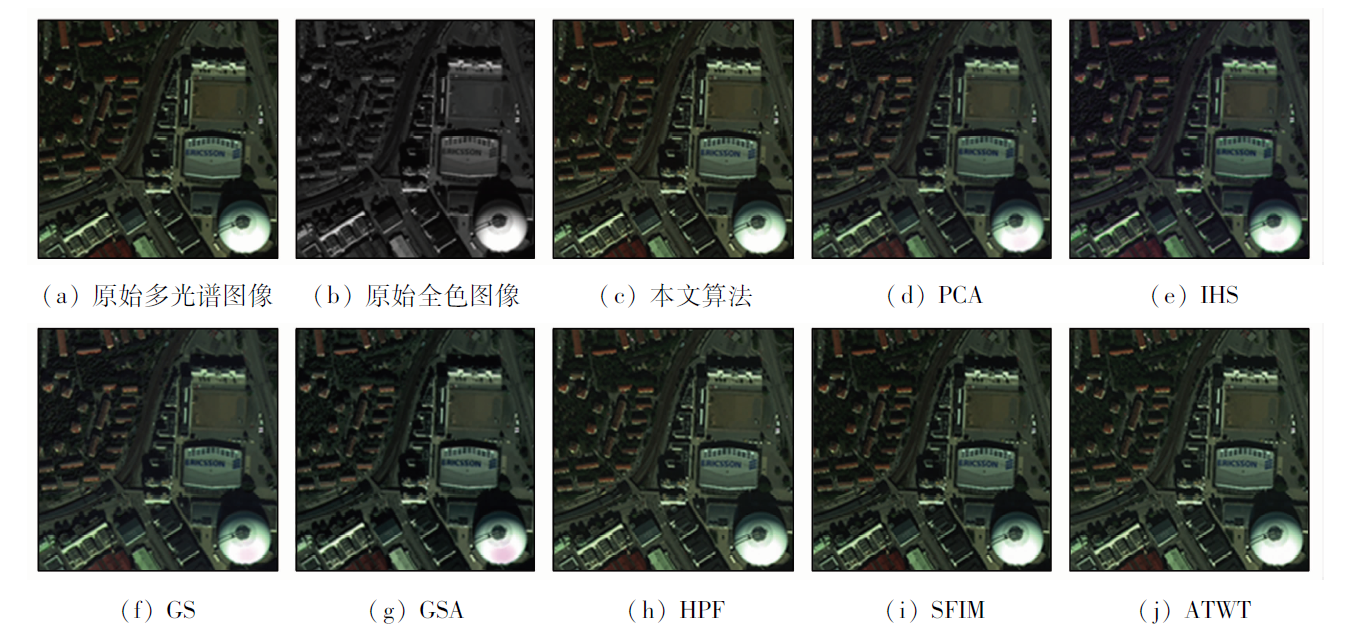
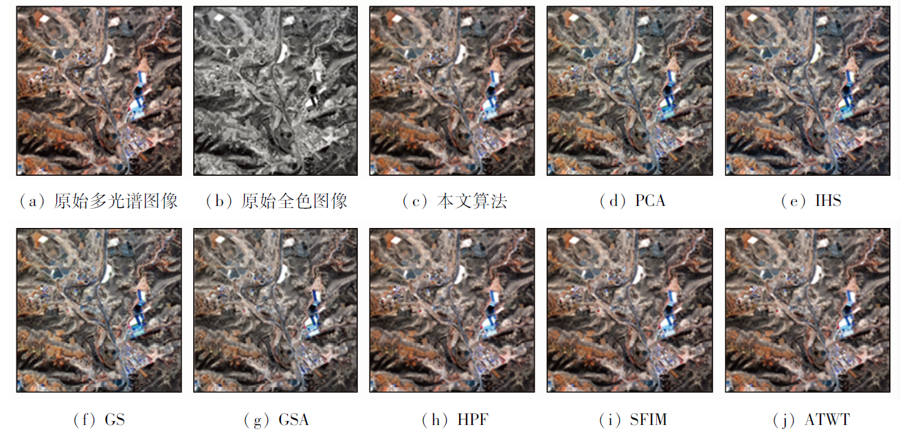
Conventional pansharpening fusion methods suffer inaccurate extraction of details and low spectrum fusion accuracy. This study proposed a pansharpening algorithm of remote sensing images based on nonsubsampled Contourlet transform (NSCT) and pulse coupled neural networks (PCNN) by combining the multi-scale and -directional decomposition characteristics of NSCT and the pulse synchronous emission characteristics of PCNN. The process of this pansharpening algorithm is as follows: first, the details of panchromatic images were extracted through NSCT; then, the extracted detail features were injected into the irregular segmentation regions obtained using the PCNN model; finally, the sharpening fusion results of high-resolution multispectral remote-sensing images were obtained through statistical weighting. As corroborated by the experimental results of WorldView-2 and GF-2 data sets, the pansharpening algorithm outperforms other remote sensing image fusion algorithms in detail preservation and spectral consistency, verifying its effectiveness.
Yang L P, Ma M, Xie W, et al. Fusion algorithm evaluation of Landsat8 panchromatic and multispetral images in arid regions[J]. Remote Sensing for Land and Resources, 2019, 31(4):11-19.doi:10.6046/gtzyyg.2019.04.02.
doi: 10.6046/gtzyyg.2019.04.02
[2]
Vivone G, Mura M D, Garzelli A, et al. A new benchmark based on recent advances in multispectral pansharpening:Revisiting pansharpening with classical and emerging pansharpening methods[J]. IEEE Geoscience and Remote Sensing Magazine, 2020, 9(1):53-56.
doi: 10.1109/MGRS.6245518
Liu W J, Gao J K, Qu H C, et al. Ship detection based on multi-scale feature enhancement of remote sensing images[J]. Remote Sensing for Natural Resources, 2021, 33(3):97-106.doi:10.6046/zrzyyg.2020372.
doi: 10.6046/zrzyyg.2020372
[4]
Li H F, Song D Z, Liu Y, et al. Automatic pavement crack detection by multi-scale image fusion[J]. IEEE Transactions on Intelligent Transportation Systems, 2018, 20(6):2025-2031.
doi: 10.1109/TITS.6979
Song Y P. Research on land use classification technology based on multi-source image fusion and object-oriented[D]. Shihezi: Shihezi University, 2020.
[6]
Kahraman S, Erturk A. Review and performance comparison of pansharpening algorithms for RASAT images[J]. Istanbul University-Journal of Electrical and Electronics Engineering, 2018, 18(1):109-120.
doi: 10.5152/iujeee.
[7]
Wady S, Bentoutou Y, Bengermikh A, et al. A new IHS and wavelet based pansharpening algorithm for high spatial resolution satellite imagery[J]. Advances in Space Research, 2020, 66(7):1507-1518.
doi: 10.1016/j.asr.2020.06.001
[8]
Du C, Gao S. Remote sensing image fusion based on nonlinear IHS and fast nonsubsampled contourlet transform[J]. Journal of the Indian Society of Remote Sensing, 2018, 46(6):2023-2032.
doi: 10.1007/s12524-018-0859-y
[9]
Wu Z, Huang Y, Zhang K. Remote sensing image fusion method based on PCA and Curvelet transform[J]. Journal of the Indian Society of Remote Sensing, 2018, 46(5):687-689.
doi: 10.1007/s12524-017-0736-0
Zhang T, Liu J, Yang K M, et al. Harmonic analysis fusion algorithm for hyperspectral image combining Gram-Schmidt transform[J]. Journal of Surveying and Mapping, 2015, 44(9):1042-1047.
[11]
Aiazzi B, Baronti S, Selva M. Improving component substitution pansharpening through multivariate regression of MS+Pan data[J]. IEEE Transactions on Geoscience and Remote Sensing, 2007, 45(10):3230-3239.
doi: 10.1109/TGRS.2007.901007
[12]
Nunez J, Otazu X, Fors O, et al. Multiresolution-based image fusion with additive wavelet decomposition[J]. IEEE Transactions on Geoscience and Remote Sensing, 1999, 37(3):1204-1211.
doi: 10.1109/36.763274
[13]
Ma D, Lai H C. Remote sensing image matching based improved ORB in NSCT domain[J]. Journal of the Indian Society of Remote Sensing, 2019, 47(5):801-807.
doi: 10.1007/s12524-019-00958-y
Wang M, He L X, Cheng Y F, et al. Panchromatic multispectral image fusion method based on adaptive Gaussian filter and SFIM model[J]. Journal of Surveying and Mapping, 2018, 47(1):82-90.
[15]
Cunha A L, Zhou J, Do M N, et al. The nonsubsampled Contourlet transform:Theory,design,and applications[J]. IEEE Transactions on Image Processing, 2006, 15(10):3089-3101.
doi: 10.1109/TIP.2006.877507
[16]
Eckhorn R, Frien A, Bauer R, et al. High frequency (60-90 Hz) oscillations in primary visual cortex of awake monkey[J]. Neuroreport, 1993, 4(3):243-246.
pmid: 8477045
Yan L, Xiang T Z. Infrared and visible image fusion based on edge feature and adaptive PCNN in NSCT domain[J]. Journal of Electronics, 2016, 44(4):761-766.
 2023, Vol. 35
  ), 李小军1,2,3(