Application of integrated remote sensing monitoring technology for geological hazards in major engineering construction:A case study of the Yanqing competition area of the Beijing 2022 Olympic Winter Games
MA Xiaoxue(), JIAO Runcheng(), CAO Ying, NAN Yun, WANG Shengyu, GUO Xuefei, ZHAO Danning, YAN Chi, NI Xuan
Beijing Institute of Geological Hazard Prevention,Beijing 100120, China
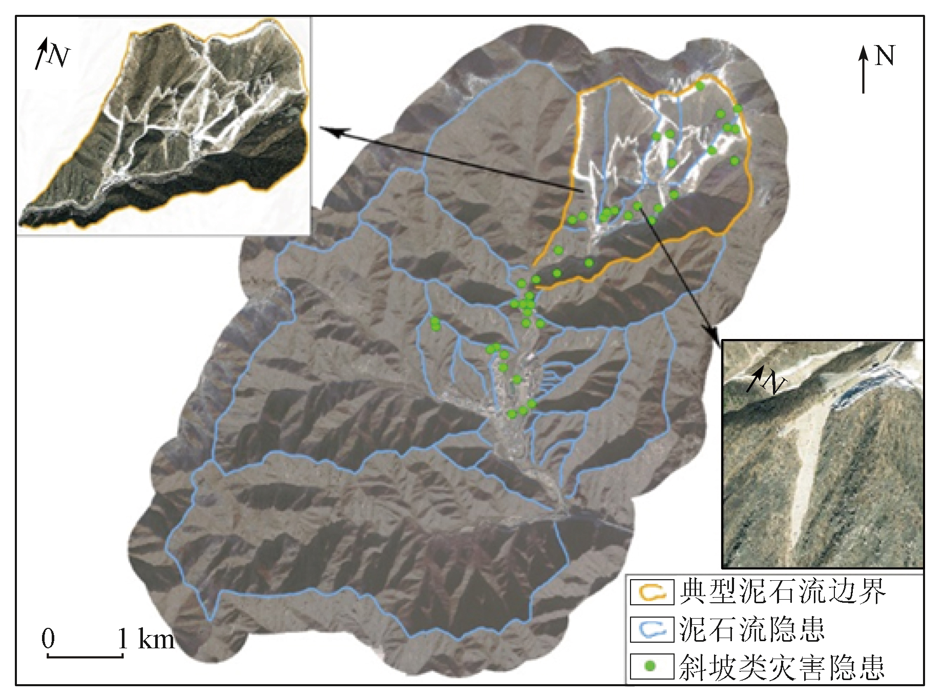
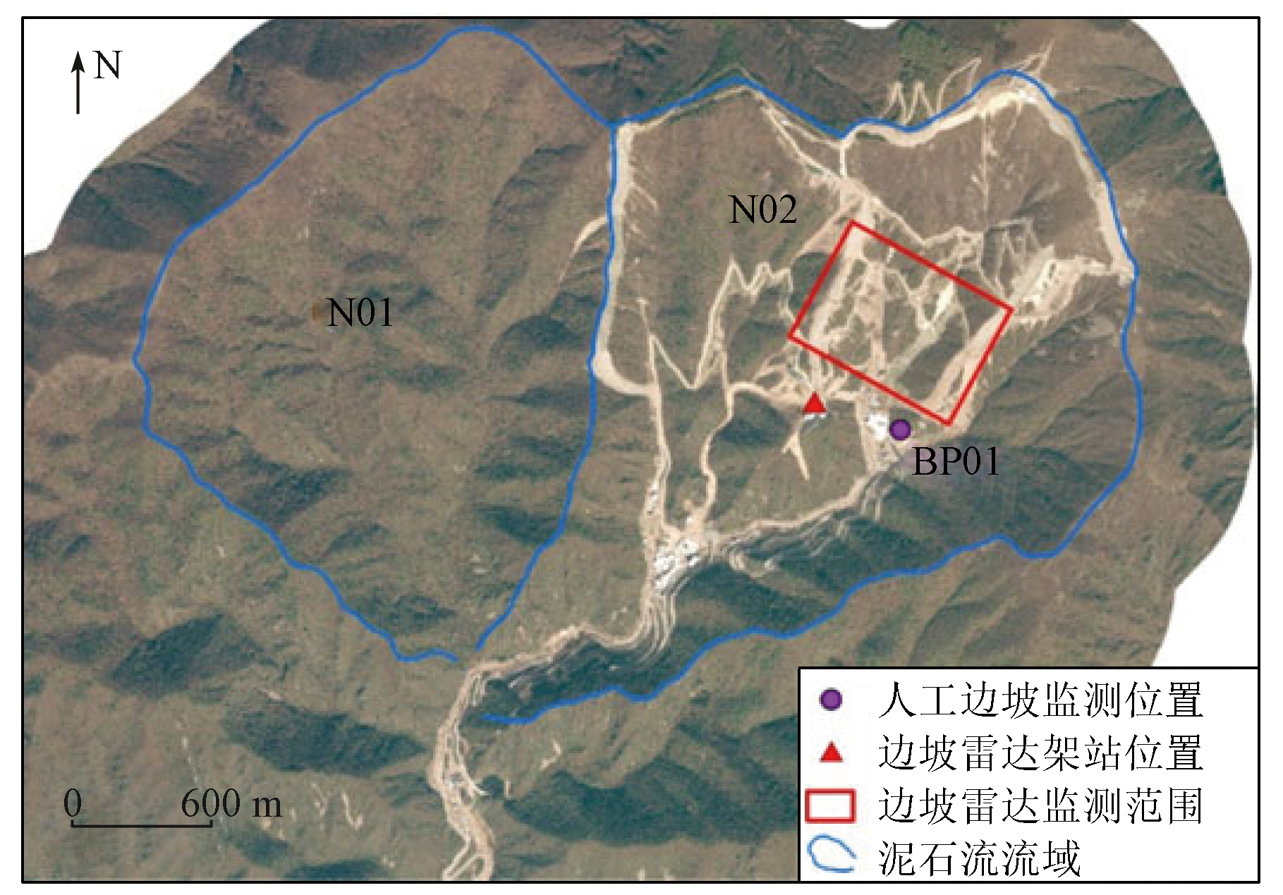
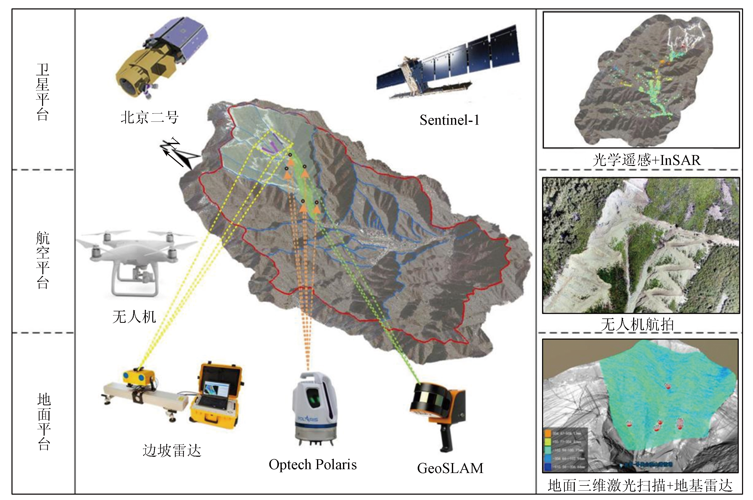
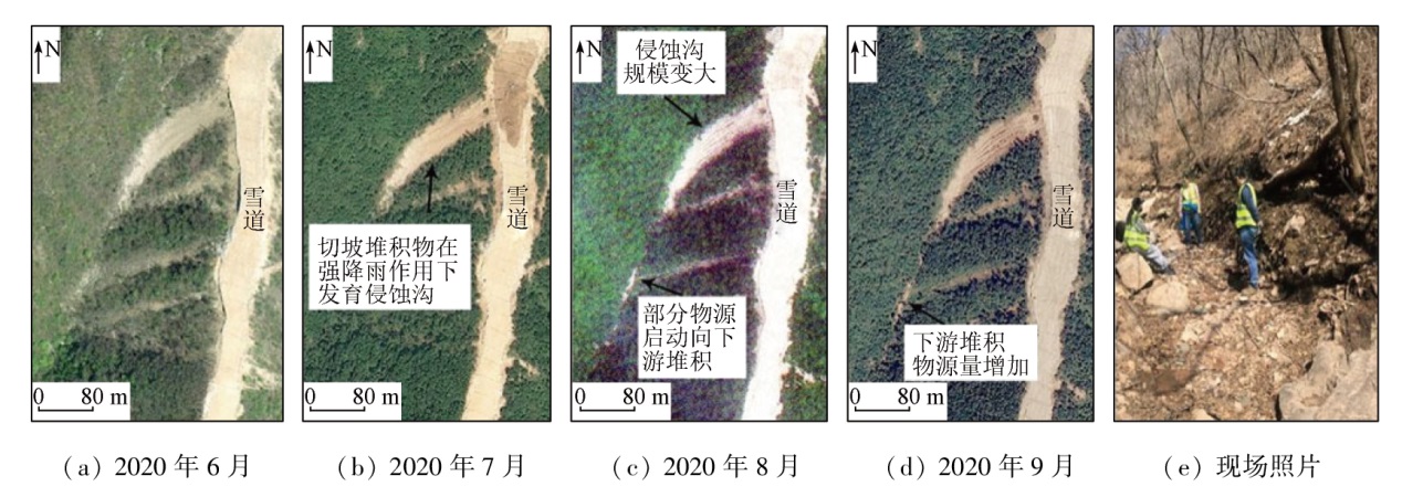
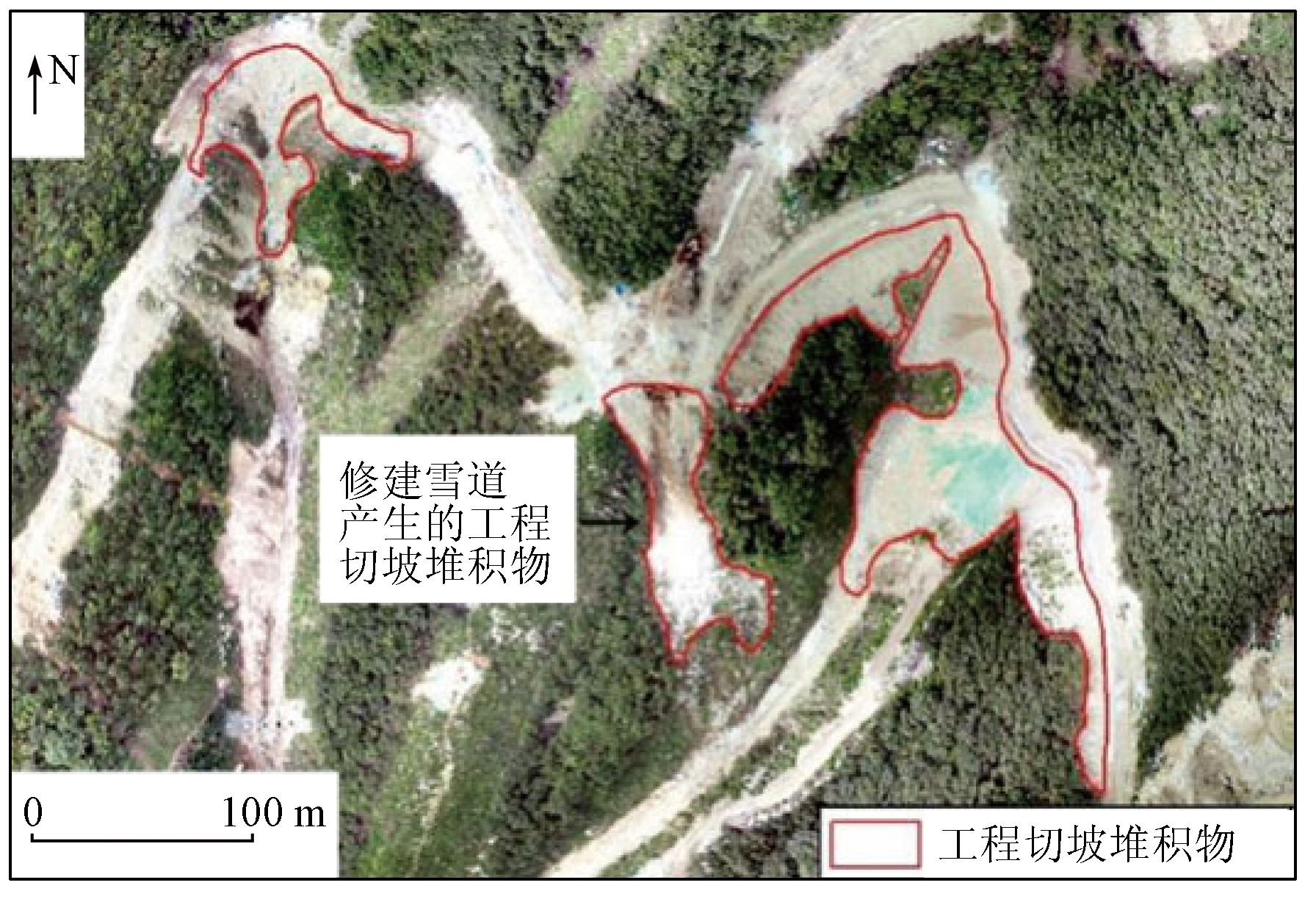
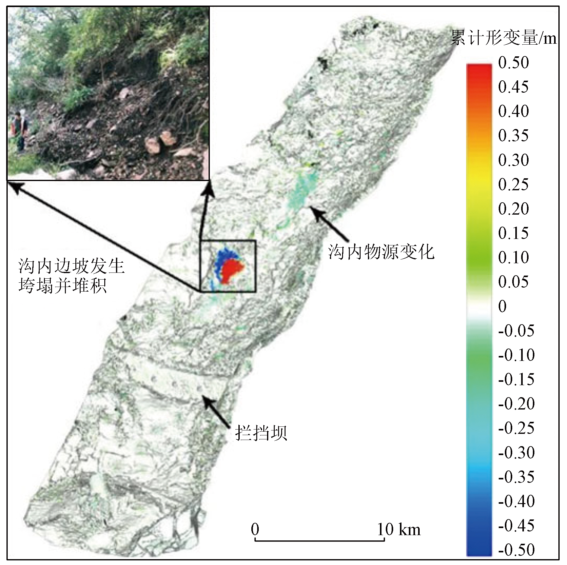
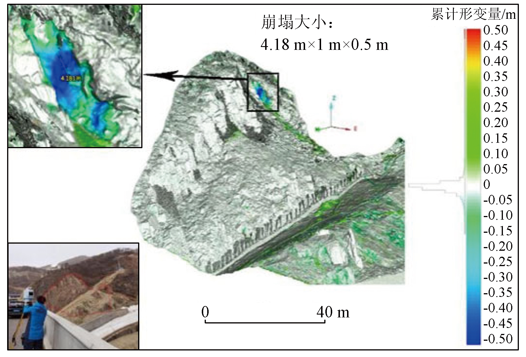
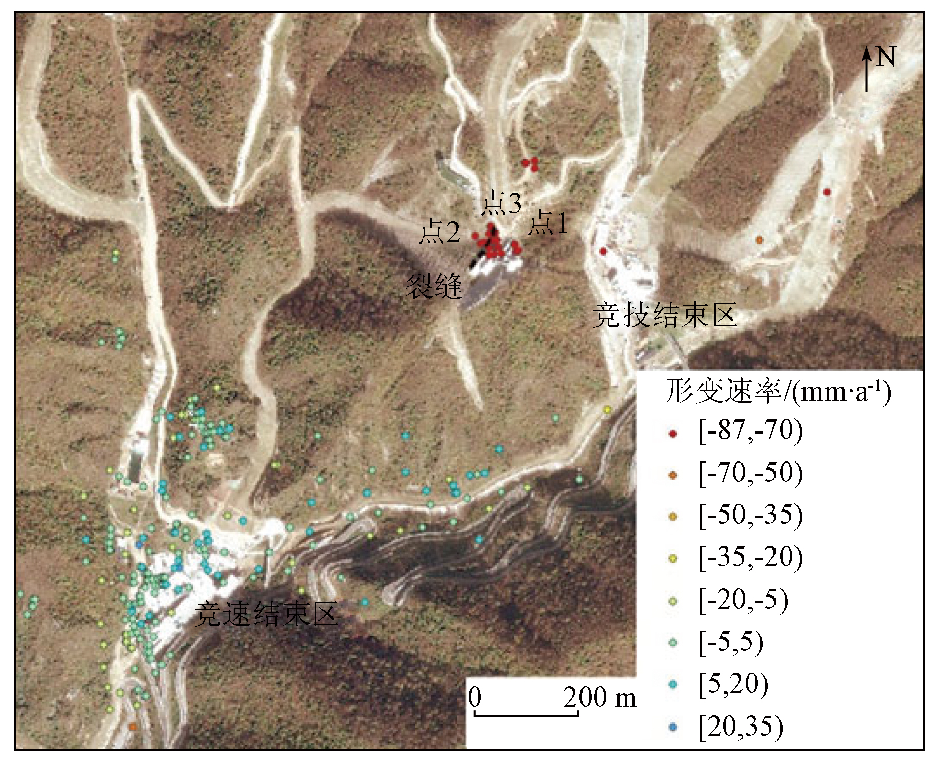
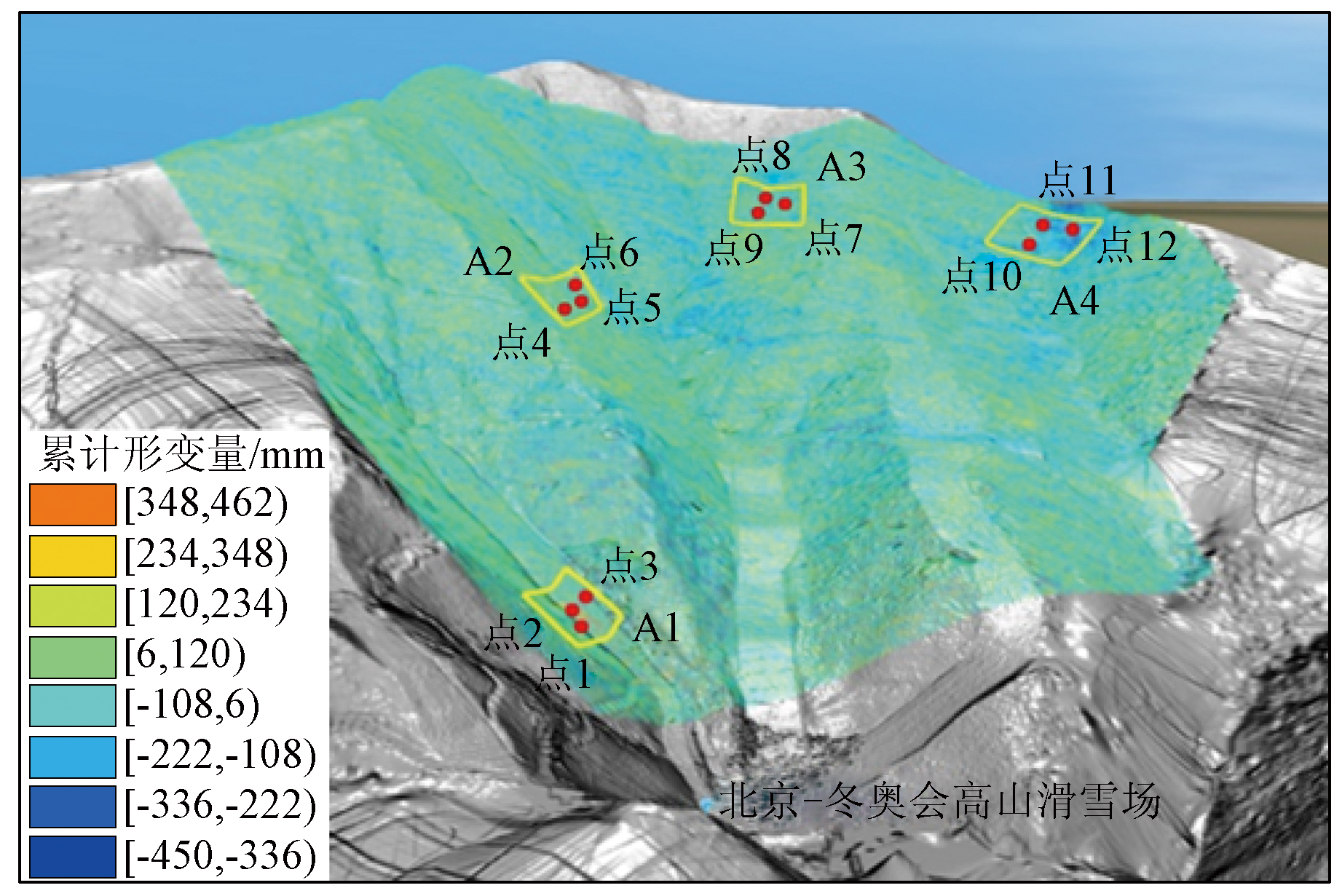
With the economic and social advancement in China, engineering construction has become a primary cause of geologic hazards. The space-air-ground integrated remote sensing monitoring technology can achieve three-dimensional monitoring at different scales, thus providing rich monitoring methods for geological hazards in major engineering construction. Based on the technology, this study investigated the Yanqing competition area of the Beijing 2022 Olympic Winter Games. Considering the various types of geological hazards in the Yanqing competition area, this study conducted dynamic monitoring of geological hazards in the area by integrating high-resolution optical remote sensing, time-series interferometric synthetic aperture radar (InSAR), unmanned aerial vehicle (UAV) photogrammetry, light detection and ranging (LiDAR), and ground-based InSAR. The dynamic monitoring results reveal the sedimentary source variations in the debris flow gully as well as the deformation zones and time-series deformation characteristics of engineering slopes and ski tracks. This study summarized the integrated remote sensing monitoring methods for geological hazards in major engineering construction, proposing an application assumption of multi-means, multi-platform, multi-disaster, and whole-process hazard monitoring.
马晓雪, 焦润成, 曹颖, 南赟, 王晟宇, 郭学飞, 赵丹凝, 闫驰, 倪璇. 重大工程建设中地质灾害综合遥感监测技术方法应用——以北京2022冬奥会延庆赛区为例[J]. 自然资源遥感, 2024, 36(2): 248-256.
MA Xiaoxue, JIAO Runcheng, CAO Ying, NAN Yun, WANG Shengyu, GUO Xuefei, ZHAO Danning, YAN Chi, NI Xuan. Application of integrated remote sensing monitoring technology for geological hazards in major engineering construction:A case study of the Yanqing competition area of the Beijing 2022 Olympic Winter Games. Remote Sensing for Natural Resources, 2024, 36(2): 248-256.
Ren Y R. On the comprehensive beneficial results of the prevention and control engineering for geological hazards in the three-gorge storage area[J]. Journal of Geological Hazards and Environment Preservation, 2002, 13(2):70-74.
Ren S, Jiang D Y, Jiang Z W, et al. Monitoring technology of geological disaster in Three Gorges Reservoir area and its prospect[J]. China Safety Science Journal, 2006(1):140-144,4.
[4]
李益陈. 库水作用下三峡库区涪陵段滑坡稳定性研究[D]. 成都: 成都理工大学, 2016.
Li Y C. Stability of landslide under the effect of reservoir water in the area of Fuling of the Three Gorges Reservoir area[D]. Chengdu: Chengdu University of Technology, 2016.
Song Y X, Zou Y J, Ye R Q, et al. Dynamic analysis of landslide hazards in the Three Gorges Reservoir area based on Google Earth Engine[J]. Remote Sensing for Natural Resources, 2024, 36(1):154-161.doi:10.6046/zrzyyg.2022464.
Yang H P, Wang J S. Geological features and cause analysis of Qianjiangping landslide of July 13,2003 on Three Gorges Reservoir[J]. Journal of Engineering Geology, 2009, 17(2):233-239.
Li T Q, Tang J, Tang D H, et al. The anslysis on causative factors and stability of a huge landslide in Danba County,Sichuan Province[J]. The Chinese Journal of Geological Hazard and Control, 2007, 18(3):16-18,24.
Yin Y P, Li T Q, Tang J. Landslide reactivation and emergency stabilization on Danba County town in Sichuan Province[J]. Chinese Journal of Rock Mechanics and Engineering, 2008 (5):971-978.
Xu Q, Huang R Q, Yin Y P,et.al. The Jiweishan landslide of June 5,2009 in Wulong,Chongqing:Characteristics and failure mechanism[J]. Journal of Engineering Geology, 2009, 17(4):433-444.
[10]
许强. 构建新“三查”体系,创新地灾防治新机制[N]. 中国矿业报,2018-03-12.
Xu Q. Constructing a new“Three-Check”System,innovating new mechanisms for disaster prevention and control[N]. China Mining Newspaper,2018-03-12.
Xu Q, Dong X J, Li W L. Integrated space-air-ground early detection,monitoring and warning system for potential catastrophic geohazards[J]. Geomatics and Information Science of Wuhan University, 2019, 44(7):957-966.
Xu Q. Understanding and consideration of related issues in early identification of potential geohazards[J]. Geomatics and Information Science of Wuhan University, 2020, 45(11):1651-1659.
Xu Q, Lu H Y, Li W L, et al. Types of potential landslide and corresponding identification technologies[J]. Geomatics and Information Science of Wuhan University, 2022, 47(3):377-387.
Ge D Q. Comprehensive application of remote sensing in early identification,monitoring and early warning in geological disasters[J]. City and Disaster Reduction, 2018(6):53-60.
Ge D Q, Dai K R, Guo Z C, et al. Early identification of serious geological hazards with integrated remote sensing technologies:Thoughts and recommendations[J]. Geomatics and Information Science of Wuhan University, 2019, 44(7):949-956.
Lu H Y, Li W L, Xu Q, et al. Early detection of landslides in the upstream and downstream areas of the baige landslide,the Jinsha River based on optical remote sensing and InSAR technologies[J]. Geomatics and Information Science of Wuhan University, 2019, 44(9):1342-1354.
Jiao R C, Guo X F, Nan Y, et al. Comprehensive remote sensing technology for goaf-landslide-debris flow disaster chain identification and evaluation[J]. Metal Mine, 2023(1):73-82.
[18]
Fruneau B, Achache J, Delacourt C. Observation and modelling of the Saint-Étienne-de-Tinée landslide using SAR interferometry[J]. Tectonophysics, 1996, 265(3-4):181-190.
[19]
Baek W K, Jung H S. Precise three-dimensional deformation retrieval in large and complex deformation areas via integration of offset-based unwrapping and improved multiple-aperture SAR interferometry:Application to the 2016 Kumamoto earthquake[J]. Engineering, 2020, 6(8):927-935.
[20]
Shi X, Yang C, Zhang L, et al. Mapping and characterizing displacements of active loess slopes along the upstream Yellow River with multi-temporal InSAR datasets[J]. Science of the Total Environment, 2019, 674:200-210.
[21]
Yao J, Lan H, Li L, et al. Characteristics of a rapid landsliding area along Jinsha River revealed by multi-temporal remote sensing and its risks to Sichuan-Tibet Railway[J]. Landslides, 2022, 19(3):703-718.
[22]
Jiao R, Wang S, Yang H, et al. Comprehensive remote sensing technology for monitoring landslide hazards and disaster chain in the Xishan mining area of Beijing[J]. Remote Sensing, 2022, 14:4695.
Yan C, Jiao R C, Cao Y, et al. The application of UAV oblique photography in debris flow disaster identification and analysis:Taking the debris flow in Caojiafang,Shijiaying,Fangshan District,Beijing as an Example[J]. Remote Sensing for Land and Resources, 2020, 32(4):251-257.doi:10.6046/gtzyyg.2020.04.31.
Guo X F, Jiao R C, Cao Y, et al. Application of oblique photography in the investigation potential of rockfall[J]. The Chinese Journal of Geological Hazard and Control, 2020, 31(1):65-69.
[25]
Liu X, Lian X, Yang W, et al. Accuracy assessment of a UAV direct georeferencing method and impact of the configuration of ground control points[J]. Drones, 2022, 6(2):30-44.
[26]
Zhang Y, Lian X, Ge L, et al. Surface subsidence monitoring induced by underground coal mining by combining DInSAR and UAV photogrammetry[J]. Remote Sensing, 2022, 14(19):4711-4724.
[27]
Gorsevski P V. An evolutionary approach for spatial prediction of landslide susceptibility using LiDAR and symbolic classification with genetic programming[J]. Natural Hazards, 2021, 108:2283-2307.
Liu Y P, Liang H, Chen F F. Application of high resolution airborne LiDAR in Xiaojiang active tectonics and geological disaster study[J]. Journal of Geomechanics, 2016, 22(3):747-759.
Jia H J, Wang L J, Fan D L. The application of UAV LiDAR and tilt photography in the early identification of geo-hazards[J]. The Chinese Journal of Geological Hazard and Control, 2021, 32(2):60-65.
Yang X L, Ma H T, Qi Y L, et al. New development of slope safety monitoring technology:Birth of slope Radar “S-SAR” Chinese Academy of Security Sciences[J]. Labour Protection, 2015(5):96-99.
Zhao D Y, Shen Q H, Ma H T, et al. Application of domestic ground based synthetic aperture Radar monitoring and warning system in slope displacement monitoring on open pit of Zijinshan gold/copper mine[J]. Journal of Safety Science and Technology, 2015, 11(4):54-58.
[32]
Han J, Yang H, Liu Y, et al. A deep learning application for deformation prediction from ground-based InSAR[J]. Remote Sensing, 2022, 14,5067.
Lin D C, Ma H T, Song B H. Application of slope Radar in landslide emergency rescue operation[J]. Journal of Safety Science and Technology, 2016, 12(s1):284-289.
Chen J, Cai J, Li J, et al. Oblique aerial photography technology and its application to geological survey:A case study of Wuxia section in the Three Gorges Reservoir[J]. Remote Sensing for Land and Resources, 2021, 33(1):167-173.doi:10.6046/gtzyyg.2020133.
Huang H F, Xue R H, Zhao B B, et al. The bedding rock landslide identification in the head area of the Three Gorges Reservoir combined with disaster pregnant mechanism and comprehensive remote sensing method[J]. Acta Geodaetica et Cartographica Sinica, 2022, 51,(10):2056-2068.
doi: 10.11947/j.AGCS.2022.20220306
Assessment report on geological hazards in Yanqing competition area of Beijing 2022 Winter Olympic Games[R], Beijing: Beijing Institute of Geological Survey,Beijing Institute of Geological Hazard Prevention, 2020.
 2024, Vol. 36
  ), 焦润成(