High-resolution remote sensing-based dynamic monitoring of coal mine collapse areas in southwestern Guizhou: A case study of coal mine collapse areas in Liupanshui City
YU Hang(), AN Na(), WANG Jie, XING Yu, XU Wenjia, BU Fan, WANG Xiaohong, YANG Jinzhong
China Aero Geophysical Survey and Remote Sensing Center for Natural Resources, Beijing 100083, China
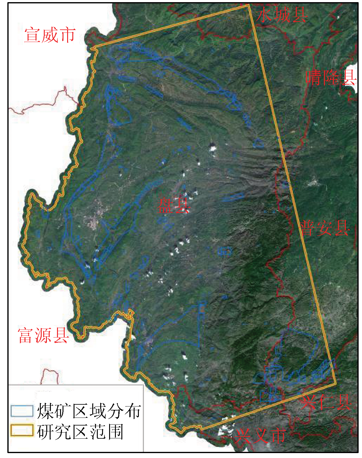
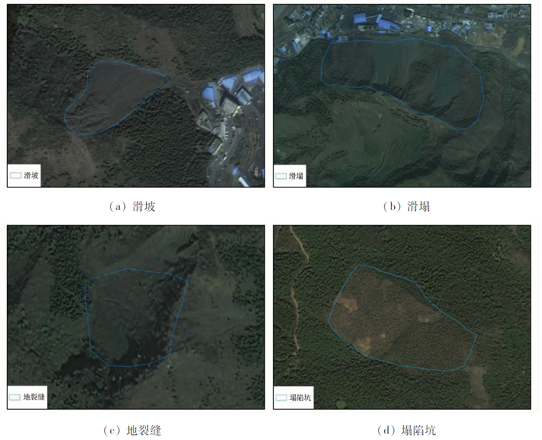
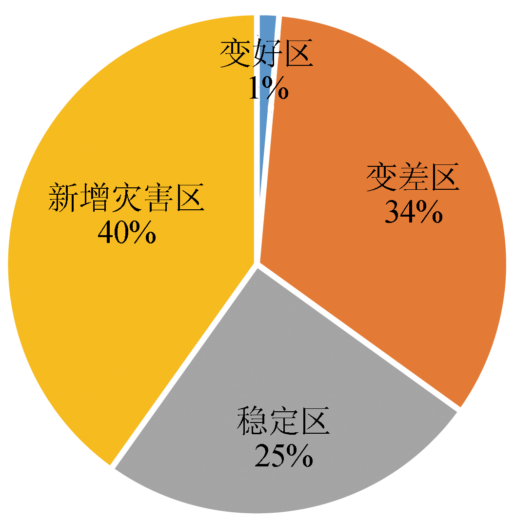
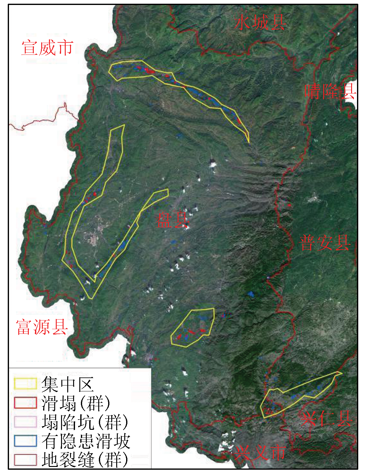
Southwestern China suffers frequent geological disasters. The exploitation of mineral resources in southwestern China is highly liable to induce geological disasters and related secondary disasters. This study investigated the remote sensing-based dynamic monitoring technology for coal mine collapse areas in the coal mining concentration areas in Liupanshui City, Guizhou Province. Based on the high-resolution remote sensing images, this study established remote sensing geological interpretation symbols of coal mine collapse areas in the mountainous plateau of southwestern Guizhou and then dynamically monitored the geological disasters in Liupanshui from 2009 to 2018. Moreover, this study analyzed the present geological disasters in the study area. The remote sensing interpretation revealed that geological disasters in the study area were significantly aggravated over the years. Compared with 2009, 2018 witnessed an increase of 167% in the geological disasters, including 40% of new geological disaster areas and 34% of areas with deteriorated geological disasters. According to the geological disaster degrees in the study area, this study identified four geological disaster concentration areas, which were highly consistent with the mining concentration areas in the study area. Based on the remote sensing data, this study analyzed the types of land damaged by geological disasters in mines and investigated possible resulting damage to the people and the ecological environment in the study area. The results show that disasters that severely damaged land caused the largest damage area for forest and cultivated lands, which had a total number of 193 and a total area of about 333.55 hm2. There are 360 areas with potential hazards in the study area, covering an area of 506.36 hm2. They are dominated by 126 threats to roads, which cover an area of 110.04 hm2. The results of this study can provide a reliable data reference and a critical research approach for restoring the local ecological environment and controlling geological disasters in mines. Moreover, based on the characteristics of the study area, this study further analyzed the causes of the geological disasters in mines, explored the geological disaster control schemes, and proposed countermeasures and suggestions.
于航, 安娜, 汪洁, 邢宇, 许文佳, 步凡, 王晓红, 杨金中. 黔西南采煤塌陷区高分遥感动态监测——以六盘水市煤矿采空塌陷区为例[J]. 自然资源遥感, 2023, 35(3): 310-318.
YU Hang, AN Na, WANG Jie, XING Yu, XU Wenjia, BU Fan, WANG Xiaohong, YANG Jinzhong. High-resolution remote sensing-based dynamic monitoring of coal mine collapse areas in southwestern Guizhou: A case study of coal mine collapse areas in Liupanshui City. Remote Sensing for Natural Resources, 2023, 35(3): 310-318.
Ministry of Land and Resources. DZ/T0223—2011 mine geological environmental protection and restoration and control plan preparation specifications[S]. Beijing: Department of Geology and Environment,Ministry of Land and Resources, 2011.
Gao J H, Liu S S, Yang J Z, et al. Gray correlation evaluation of geo-logical environment in the open-pit coal mine concentration area based on remote sensing:A case study of the Zhungeer Coalfield[J]. Remote Sensing for Land and Resources, 2021, 33(3):183-190.doi:10.6046/gtzyyg.2020006.
doi: 10.6046/gtzyyg.2020006
Wang X H, Jing Q Q, Zhou Y J, et al. Remote sensing dynamic monitoring of coal mine subsidence disaster in Shandong Province[J]. Remote Sensing for Land and Resources, 2017, 29(3):203-210.doi:10.6046/gtzyyg.2017.03.30.
doi: 10.6046/gtzyyg.2017.03.30
Gao Q W, Niu J C. The coalfield exploitation subsidence and analyses on its effective factors[J]. The Chinese Journal of Geological Hazard and Control, 1997, 8(3):57-61.
Li C Z, Nie H F, Wang J, et al. Remote sensing study on mine geological disaster characteristics[J]. Remote Sensing for Land and Resources, 2005, 17(1):45-48,78.doi:10.6046/gtzyyg.2005.01.11.
doi: 10.6046/gtzyyg.2005.01.11
Du P J, Chen Y H, Cao J L, et al. The key technology of remote sensing integrated monitoring system of geological environment and geological disaster in coal mine area[J]. Geomatics World, 2008, 10(5):14-20.
Xu G, Zheng D X, Li S J, et al. Remote sensing images and distribution characteristics of avalanche and landslide geohazards in the western part of the Weibei Plateau,Shaanxi Province,China[J]. Geological Bulletin of China, 2008, 27(11):1837-1845.
Feng Y L, Chen J, Jing Q G, et al. The application of 3D remote sensing image model of debris flow disaster warning in Gu-xiang gully,Tibet[J]. Journal of Geological Hazards and Environment Preservation, 2009, 20(3):114-119.
Pu G L, Yang W N, Liu H C. Applications of orthophoto map of landsat TM to the study of cracks and landslides on upper reaches of the Minjiang River[J]. Journal of Chengdu University of Technology, 2000, 27(3):312-317.
Gu G M, Wang L, Jiang D L, et al. Application of 3S technology to monitoring development and environment conditions in coal mine area[J]. Coal Geology and Exploration, 2006, 34(5):51-55.
Shang H Y, Chen J P, Li C Z, et al. Application of remote sensing in the dynamic inspection of the mining:An example in the rare metal ore concentration area of Xinjiang[J]. Remote Sensing Technology and Application, 2008, 23(2):189-195.
Qiao Y X, Li M W, Zhang W C. Comprehensive evaluation on geological hazards and the environment of developing geological hazards in the northwest Hebei on the basis of RS[J]. The Chinese Journal of Geological Hazard and Control, 2002, 13(4):83-87.
Wang Q J, Chen Y, Lin Q Z, et al. Remote sensing monitoring method and cause analysis of mine geological disaster:Take Shijiaying coal mine in Fangshan District,Beijing as an example[J]. The Chinese Journal of Geological Hazard and Control, 2011, 22(1):75-79.
[16]
何国清, 杨伦, 凌赓娣, 等. 矿山开采沉陷学[M]. 徐州: 中国矿业大学出版社,1991.
He G Q, Yang L, Ling G D, et al. Mining subsidence theory[M]. Xuzhou: China University of Mining and Technology Publisher,1991.
Sha Y L, Wang X W, Liu G X, et al. SBAS-In SAR-based monitoring and inversion of surface subsidence of the Shadunzi coal mine in Hami City,Xinjiang[J]. Remote Sensing for Natural Resources, 2021, 33(3):194-201.doi:10.6046/zrzyyg.2020026.
doi: 10.6046/zrzyyg.2020026
Sang X, Zhang C Y, Li J, et al. Application of intensity analysis theory in the land use change in Yijin Holo Banner under the background of coal mining[J]. Remote Sensing for Natural Resources, 2021, 33(3):148-155.doi:10.6046/zrzyyg.2020358.
doi: 10.6046/zrzyyg.2020358
Yang X H, Huang J, Tian L, et al. Application of mine remote sensing monitoring to analysis of mine goaf stability[J]. Remote Sensing for Land and Resources, 2018, 30(3):143-150.doi:10.6046/gtzyyg.2018.03.20.
doi: 10.6046/gtzyyg.2018.03.20
Yi T S, Gao W. Reservoir formation characteristics as well as co-exploration and co-mining orientation of Upper Permian coal-bearing gas in Liupanshui coalfield[J]. Journal of China Coal Society, 2018, 43(6):1553-1564.
Wu C F, Liu X L, Zhang S S. Construction of “hierarchical” geological selection index system for coalbed methane in multi coal seam areas of eastern Yunnan and western Guizhou[J]. Journal of China Coal Society, 2018, 43(6):1647-1653.
Gao W, Tian W J, Qin W, et al. Geological optimization of coalbed methane and shale gas co-exploration and concurrent production in Guizhou Province[J]. Fault-Block Oil and Gas Field, 2014, 21(1):36-38.
Chi H P, Bi C Q, Shan Y S, et al. Reservoir characteristics and recoverability of CBM resource in Duge coalfield of western Guizhou[J]. Journal of China Coal Society, 2018, 43(12):3447-3452.
Gao W, Yi T S, Jin J, et al. Pore integrated fractal characteristics of coal sample in western Guizhou and its impact to porosity and permeability[J]. Journal of China Coal Society, 2017, 42(5):1258-1265.
Gao W, Yi T S. Pore features of coal reservoir in Song-he mine field of west Guizhou and its impact to permeability[J]. Coal Science and Echnology, 2016, 44(2):55-61.
Gao W, Han Z Q, Lyu F, et al. Geological characteristics of gas in coal seam and cause of difference in Liupanshui area[J]. Coal Science and Technology, 2022, 50(11):122-130.
Chen L, Jia J, Wang H Q. An overview of applying high resolution remote sensing to land and resources survey[J]. Remote Sensing for Land and Resources, 2019, 31(1):1-7.doi:10.6046/gtzyyg.2019.01.01.
doi: 10.6046/gtzyyg.2019.01.01
Zheng X W, Peng B, Shang K. Assessment of the interpretation ability of domestic satellites in geological remote sensing[J]. Remote Sensing for Natural Resources, 2021, 33(3):1-10.doi:10.6046/zrzyyg.2020357.
doi: 10.6046/zrzyyg.2020357
China Geological Survey. Code for investigation of landslide,collapse and debris flow disasters(1∶50 000):DD2008-02[S]. Beijing: China Geological Survey, 2008:9-15.
Tong L Q, Guo Z C. Study on remote sensing image characteristics of typical landslide[J]. Remote Sensing for Land and Resources, 2013, 25(1):86-92.doi:10.6046/gtzyyg.2013.01.16.
doi: 10.6046/gtzyyg.2013.01.16
Zhang Z J, Li Y S, Qi W Q, et al. Investigation and evaluation of geological hazards using GF-2 remote sensing technology in Aoyitage-Taheman section of highway G314[J]. Journal of Hefei University of Technology(Natural Science), 2021, 44(9):1249-1257.
Wang Q Y, Zhang J. Landslide texture feature extraction method from high resolution remote sensing images[J]. Journal of Taiyuan University of Technology, 2021, 52(4):547-556.
Wang X W, Liu Q, Zhang B, et al. Multi-source remote sensing monitoring and analysis of glacier tongue slide in Kunlun Mountain Pass in recent 40 years[J]. Geomatics and Information Science of Wuhan University, 2020, 45(11):1687-1696.
Hou E K, Zhang J, Xie X S, et al. Comparison of UAV remote sensing and satellite remote sensing in coal mining surface crack identification[J]. Geological Bulletin of China, 2019, 38(s1):261-266.
Wei C J, Wang Y J, Wang J, et al. Research on information technology of ground fracture extraction from mining area by UAV image[J]. Metal Mine, 2012, 41(10):90-92.
Wei B W, Liu G X, Wang Z H. Based on improved MF-FDOG algorithm and UAV image extraction of ground fractures in loess region[J]. Surveying and Mapping, 2018, 41(2):51-56,61.
Zhang X H, Zhu L, Wang W, et al. Research and application of object-based step extraction method for ground fracture[J]. Remote Sensing for Land and Resources, 2019, 31(1):87-94.doi:10.6046/gtzyyg.2019.01.12.
doi: 10.6046/gtzyyg.2019.01.12
Zhang D H, Lu Z Z, Qiang J H, et al. Study on the characteristics of ground collapse and its remote sensing recognition method[J]. Journal of Geological Hazards and Environment Preservation, 2009, 20(3):8-12.
Yang S J, Zhao Y, Wu Q Y, et al. Mining subsidence extraction from high resolution remote sensing images:Take Longkou mining area as an example[J]. Areal Research and Development, 2006, 25(4):120-124.
[42]
孙超. 地下采空区对地表稳定性的影响[D]. 哈尔滨: 中国地震局工程力学研究所, 2005.
Sun C. Influence of underground goaf on surface stability[D]. Harbin: Institute of Engineering Mechanics,China Seismological Bureau, 2005.
Xu C H, Gao J X, Wang J, et al. Application research of multi-source multi-temporal remote sensing data fusion in coal mine subsidence[J]. Research of Soil and Water Conservation, 2008, 15(1):92-96.
Du P J, Guo D Z. Research on mining subsidence extraction method from remote sensing image supported by GIS[J]. Journal of Image and Graphics, 2003, 8(2):231-235.
Zhao Y L. Study and application of analytic hierarchy process of mine geological environment:A case study in Hainan Island[J]. Remote Sensing for Land and Resources, 2020, 32(1):148-153.doi:10.6046/gtzyyg.2020.01.20.
doi: 10.6046/gtzyyg.2020.01.20
 2023, Vol. 35
  ), 安娜(