Impacts of different proportions of contextual information on the construction of sample sets of remote sensing scene images for damaged buildings
TAI Jiayi1(), SHEN Li1(), QIAO Wenfan1, ZHOU Wuzhen2
1. Faculty of Geosciences and Environment Engineering, Southwest Jiaotong University, Chengdu 610097, China 2. Sichuan Institute of Land Science and Technology, Sichuan Center of Satellite Application Technology, Chengdu 610045, China
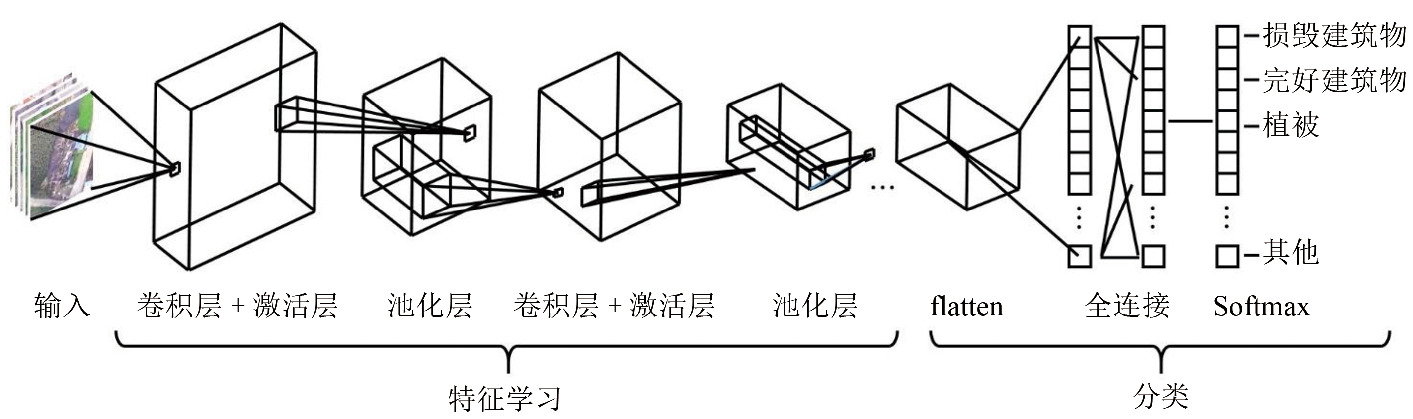
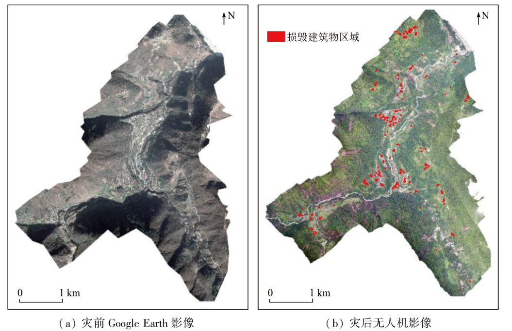
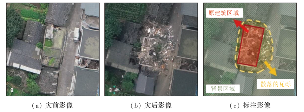
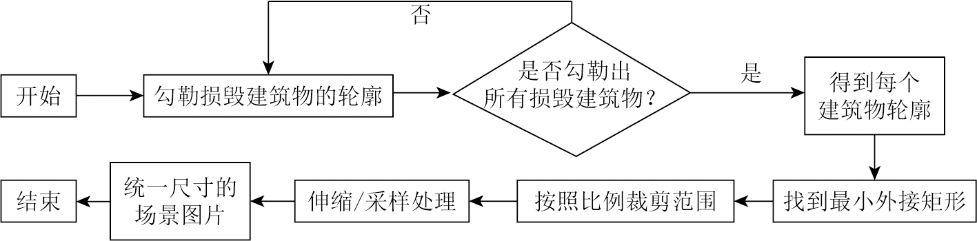
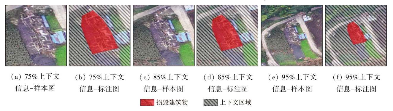
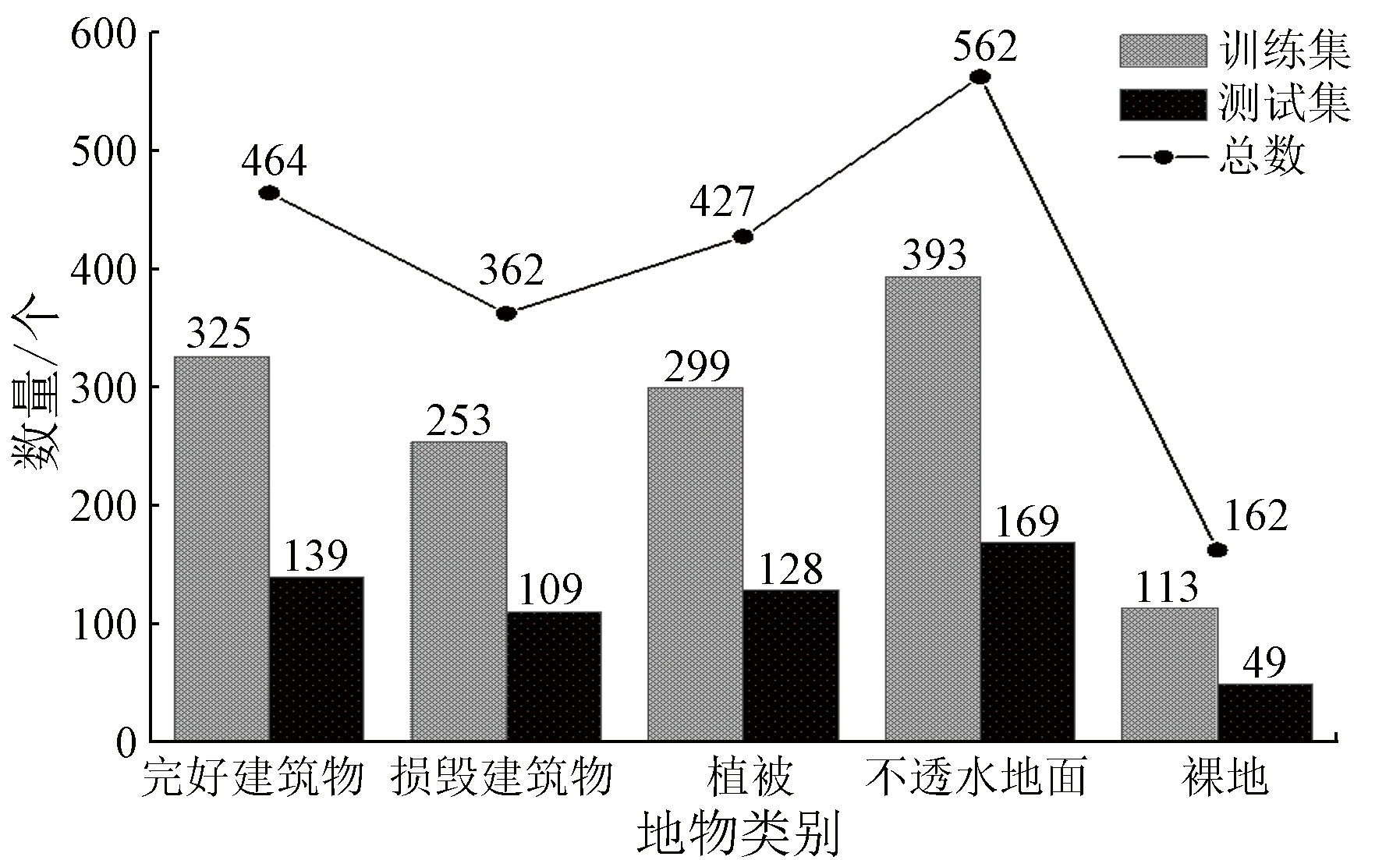
Deep learning-based scene analysis of remote sensing images serves as a critical means for post-earthquake damage assessment. Given scarce images of damaged buildings, constructing high-quality sample sets of remote sensing scene images holds crucial significance for improving the accuracy of scene recognition and classification. The proportion of contextual information in scene images, as a significant reference for remote sensing analysis, is a key factor affecting the construction effects of sample sets. Currently, the appropriate proportion of contextual information remains under-studied in the sample set construction method. Aiming to construct high-quality sample sets, this study designed a method for adjusting the proportion of contextual information in scene images. It investigated the impacts of different proportions of contextual information on the construction of scene sample sets, exploring the optimal proportion range of contextual information. This study constructed six sample sets of scene images under different proportions of contextual information for training and testing in five classic convolutional neural network (CNN) models. It analyzed the classification results of all the CNN models under different proportions of contextual information. The results indicate that with the proportion of contextual information being 80%, the classification accuracy of the CNN reached an optimal value of 92.22%, which decreased to 89.03% with the proportion of contextual information at 95%. Among all the CNN models, GoogLeNet exhibited superior classification performance with an average accuracy of 93.13%. This study enables the setting of proper proportion ranges of contextual information in scene sample sets, thus effectively improving the classification accuracy of remote sensing scene images, and guiding the construction of sample sets of remote sensing scene images for damaged buildings.
邰佳怡, 慎利, 乔文凡, 周吾珍. 不同上下文比例对损毁建筑遥感场景图片样本集构建的影响[J]. 自然资源遥感, 2024, 36(3): 154-162.
TAI Jiayi, SHEN Li, QIAO Wenfan, ZHOU Wuzhen. Impacts of different proportions of contextual information on the construction of sample sets of remote sensing scene images for damaged buildings. Remote Sensing for Natural Resources, 2024, 36(3): 154-162.
Dong J. Ministry of Emergency Management released the basic information of natural disasters across the country in 2022[EB/OL].(2023-01-13) [2023-03-08]. https://cn.chinadaily.com.cn/a/202301/13/WS63c14826a3102ada8b22b340.html.
Sui H G, Liu C X, Huang L H, et al. Application of remote sensing technology in earthquake-induced building damage detection[J]. Geomatics and Information Science of Wuhan University, 2019, 44(7):1008-1019.
[3]
Shafique A, Cao G, Khan Z, et al. Deep learning-based change detection in remote sensing images:A review[J]. Remote Sensing, 2022, 14(4):871.
[4]
Li Y, Zhang Y, Zhu Z. Error-tolerant deep learning for remote sensing image scene classification[J]. IEEE Transactions on Cybernetics, 2021, 51(4):1756-1768.
[5]
Yu X, Wu X, Luo C, et al. Deep learning in remote sensing scene classification:A data augmentation enhanced convolutional neural network framework[J]. GIScience & Remote Sensing, 2017, 54(5):741-758.
Feng Q L, Chen B A, Li G Q, et al. A review for sample datasets of remote sensing imagery[J]. National Remote Sensing Bulletin, 2022, 26(4):589-605.
[7]
Yang Y, Newsam S. Bag-of-visual-words and spatial extensions for land-use classification[C]// Proceedings of the 18th SIGSPATIAL International Conference on Advances in Geographic Information Systems.ACM, 2010: 270-279.
[8]
Weber E, Kané H. Building disaster damage assessment in satellite imagery with multi-temporal fusion[J/OL]. arXiv, 2020(2020-04-12). http://arxiv.org/abs/2004.05525v1.
[9]
Xie Y, Feng D, Chen H, et al. Damaged building detection from post-earthquake remote sensing imagery considering heterogeneity characteristics[J]. IEEE Transactions on Geoscience and Remote Sensing, 2022, 60:4708417.
[10]
Chen S A, Escay A, Haberland C, et al. Benchmark dataset for automatic damaged building detection from post-hurricane remotely sensed imagery[J/OL]. arXiv, 2018(2018-12-13). http://arxiv.org/abs/1812.05581v1.
[11]
Gupta R, Goodman B, Patel N, et al. Creating xBD:A dataset for assessing building damage from satellite imagery[C]// Proceedings of the IEEE/CVF Conference on Computer Vision and Pattern Recognition Workshops.IEEE, 2019:10-17.
Yuan J J, Hu Y L, Sun Y F, et al. Survey of small object detection methods based on deep learning[J]. Journal of Beijing University of Technology, 2021, 47(3):293-302.
Chen D, Wan G, Li K. Object detection in optical remote sensing images based on combination of multi-layer feature and context information[J]. Acta Geodaetica et Cartographica Sinica, 2019, 48(10):1275-1284.
doi: 10.11947/j.AGCS.2019.20180431
[16]
Wang C, Qiu X, Huan H, et al. Earthquake-damaged buildings detection in very high-resolution remote sensing images based on object context and boundary enhanced loss[J]. Remote Sensing, 2021, 13(16):3119.
[17]
Zhang J, Xie C, Xu X, et al. A contextual bidirectional enhancement method for remote sensing image object detection[J]. IEEE Journal of Selected Topics in Applied Earth Observations and Remote Sensing, 2020, 13:4518-4531.
[18]
LeCun Y, Boser B, Denker J S, et al. Backpropagation applied to handwritten zip code recognition[J]. Neural Computation, 1989, 1(4):541-551.
The 6.8-magnitude earthquake in Luding,Sichuan caused serious damage to houses,roads and other infrastructure[EB/OL]. Beijing Daily, 2022(2022-09-06) [2023-03-08]. https://news.bjd.com.cn/2022/09/06/10148564.shtml.
The 6.8-magnitude earthquake in Luding,Sichuan has caused 93 deaths and 25 missing[EB/OL]. Sina Finance Headline, 2022(2022-09-12) [2023-03-08]. https://cj.sina.com.cn/articles/view/5182171545/134e1a99902001eqoe.
 2024, Vol. 36
  ), 慎利1(