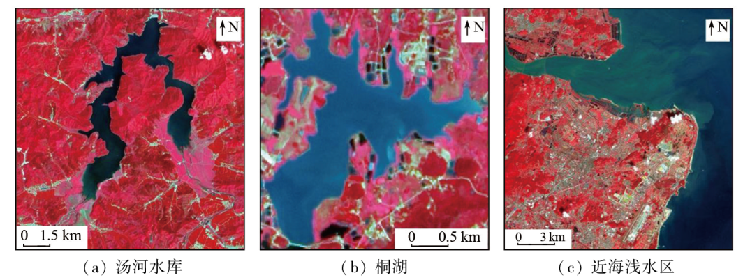
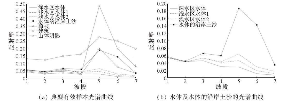
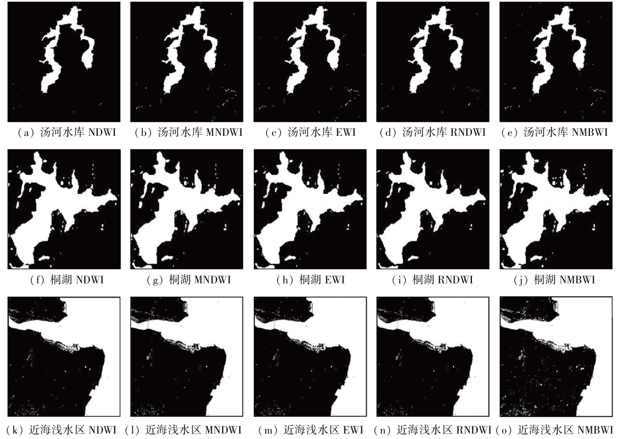
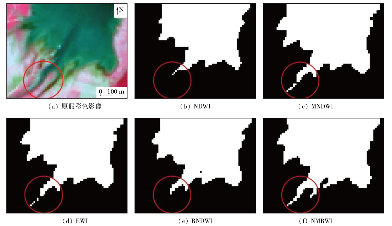
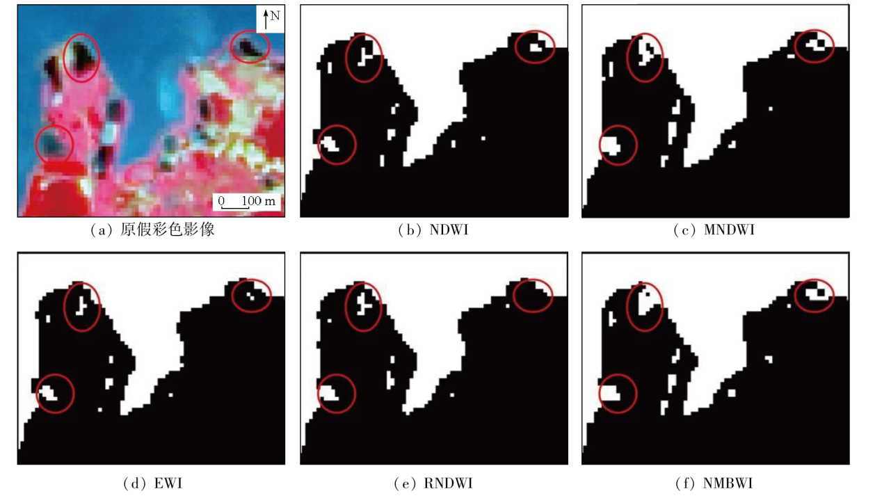
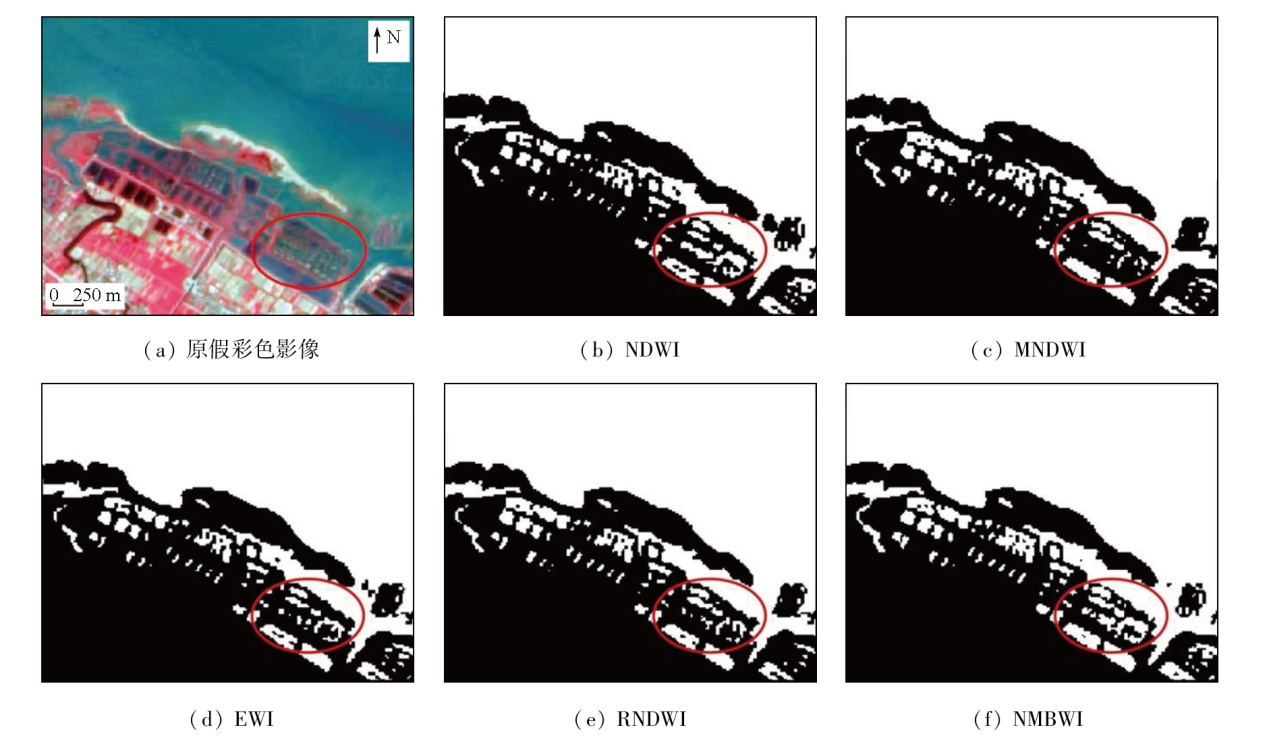
针对传统水体指数模型易受水体边界浅水区的水体底质的影响,导致在提取水体时容易产生水体错分和遗漏等问题,该文以汤河水库、桐湖和近海浅水区为研究对象,基于Landsat影像的典型地物光谱信息构建了一种新型多波段水体指数(new multi band water index,NMBWI)。与传统水体指数模型归一化差异水体指数(normalized difference water index,NDWI)、改进的归一化差异水体指数(modified normalized difference water index,MNDWI)、增强型水体指数(enhanced water index,EWI)及修订型归一化水体指数(revised normalized difference water index,RNDWI)进行了对比分析,结果表明: NMBWI对于水体边界的浅水区水体强化效果更佳,提取的水域范围更为完整,总体精度和Kappa系数总体优于传统水体指数模型且NMBWI对不同类型水体边界的浅水区水体提取具有较好的普适性和稳定性。
Traditional water-body index models exhibit high susceptibility to sediments in the shallow water areas at the boundaries of water bodies. This susceptibility leads to challenges such as water misclassification and omissions during water information extraction. Focusing on the Tanghe Reservoir, Tonghu Lake, and shallow offshore areas, this study developed a new multi-band water index (NMBWI) based on the spectral information of typical surface features derived from Landsat images. The comparison with traditional water-index models, including NDWI, MNDWI, EWI, and RNDWI, reveals that NMBWI can significantly enhance the detection effects of shallow water areas at water body boundaries, resulting in more comprehensive extraction results of water areas. NMBWI outperforms traditional water index models in terms of overall accuracy and Kappa coefficient. Furthermore, NMBWI demonstrates high universality and stability in the information extraction of shallow water areas across various water body boundaries.
罗鑫, 王崇倡, 孙尚宇. 面向水体浅水区遥感识别的水体指数NMBWI研究[J]. 自然资源遥感, 2024, 36(4): 142-148.
LUO Xin, WANG Chongchang, SUN Shangyu. Water body index NMBWI for remote sensing-based identification of shallow water areas. Remote Sensing for Natural Resources, 2024, 36(4): 142-148.
Chen Z D, Xu C X. Protecting the source of life-paying attention to eutrophication of water body[J]. Scientific and Cultural Popularization of Natural Resources, 2021(2):30-33.
[2]
邱柯卫. 渗透蒸发法海水淡化过程研究[D]. 天津: 天津大学, 2020.
Qiu K W. Study on seawater desalination process by pervaporation[D]. Tianjin: Tianjin University, 2020.
Liu M, Huang J H, Peng Z H, et al. Extraction of shallow water bodies in Shenzhen using 0.5 m resolution satellite data[J]. Bulletin of Surveying and Mapping, 2023(6):146-149,175.
doi: 10.13474/j.cnki.11-2246.2023.0184
Ren C, Deng S Q, Gao M F. A method for extracting dynamic threshold value of water body information in Beibu Gulf coastal area[J]. Bulletin of Surveying and Mapping, 2022(5):14-19,37.
doi: 10.13474/j.cnki.11-2246.2022.0134
Huang X C, Chen S B, Zhang B, et al. Analysis of water area change in Chagan Lake based on long period remote sensing data[J]. World Geology, 2023, 42(1):176-183.
Wang Y Y, Tan X C, Dong J, et al. Monitoring for Dongping Lake area variation based on remote sensing data[J]. Journal of Shandong Agricultural University (Natural Science Edition), 2020, 51(4):655-659.
[7]
Deng Y, Jiang W, Tang Z, et al. Long-term changes of open-surface water bodies in the Yangtze River basin based on the Google Earth Engine cloud platform[J]. Remote Sensing, 2019, 11(19):2213.
[8]
McFeeters S K. The use of the normalized difference water index (NDWI) in the delineation of open water features[J]. International Journal of Remote Sensing, 1996, 17(7):1425-1432.
Xu H Q. A study on information extraction of water body with the modified normalized difference water index (MNDWI)[J]. Journal of Remote Sensing, 2005, 9(5):589-595.
Yan P, Zhang Y J, Zhang Y. A study on information extraction of water system in semi-arid regions with the enhanced water index(EWI) and GIS based noise remove techniques[J]. Remote Sensing Information, 2007, 22(6):62-67.
Cao R L, Li C J, Liu L Y, et al. Extracting Miyun reservoir’s water area and monitoring its change based on a revised normalized different water index[J]. Science of Surveying and Mapping, 2008, 33(2):158-160.
Li J F, Ye H P, Zhang Z K, et al. Spatiotemporal change analysis of Sri Lanka inland water based on landsat imagery[J]. Journal of Geo-Information Science, 2019, 21(5):781-788.
Xiao Q, Yang K, Hong L. Remote sensing monitoring and temporal-spatial analysis of surface water body area changes of lakes on the Yunnan-Guizhou Plateau over the past 30 years[J]. Journal of Lake Sciences, 2018, 30(4):1083-1096.
Han W X, Huang C L, Wang Y C, et al. Study on the area variation of Qinghai Lake based on long-term landsat 5/8 multi-band remote sensing imagery[J]. Advances in Earth Science, 2019, 34(4):346-355.
doi: 10.11867/j.issn.1001-8166.2019.4.0346
Wang X B, Xie S P, Du J K. Water index formulation and its effectiveness research on the complicated surface water surroundings[J]. Journal of Remote Sensing, 2018, 22(2):360-372.
 2024, Vol. 36
  ), 王崇倡(