1. 248 Geological Brigade of Shandong Nuclear Industry,Qingdao 266041, China 2. Qingdao Survey and Mapping Research Institute, Qingdao, 266033, China 3. School of Environmental Science and Engineering, Tiangong University, Tianjin 300387, China 4. Marine Ecological Restoration and Smart Ocean Engineering Research Center of Hebei Province, Qinhuangdao 066000,China
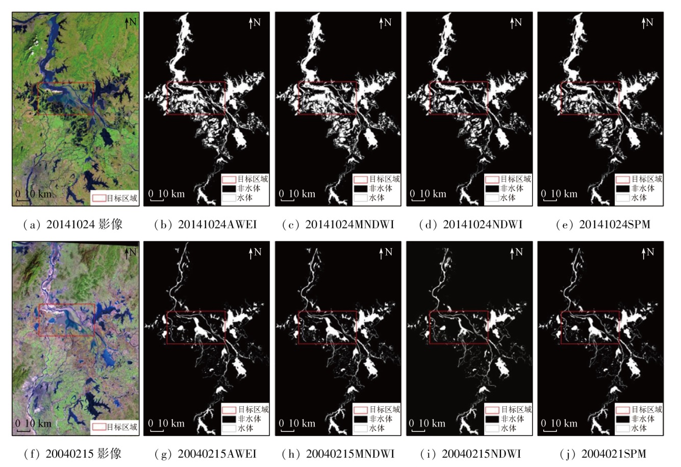
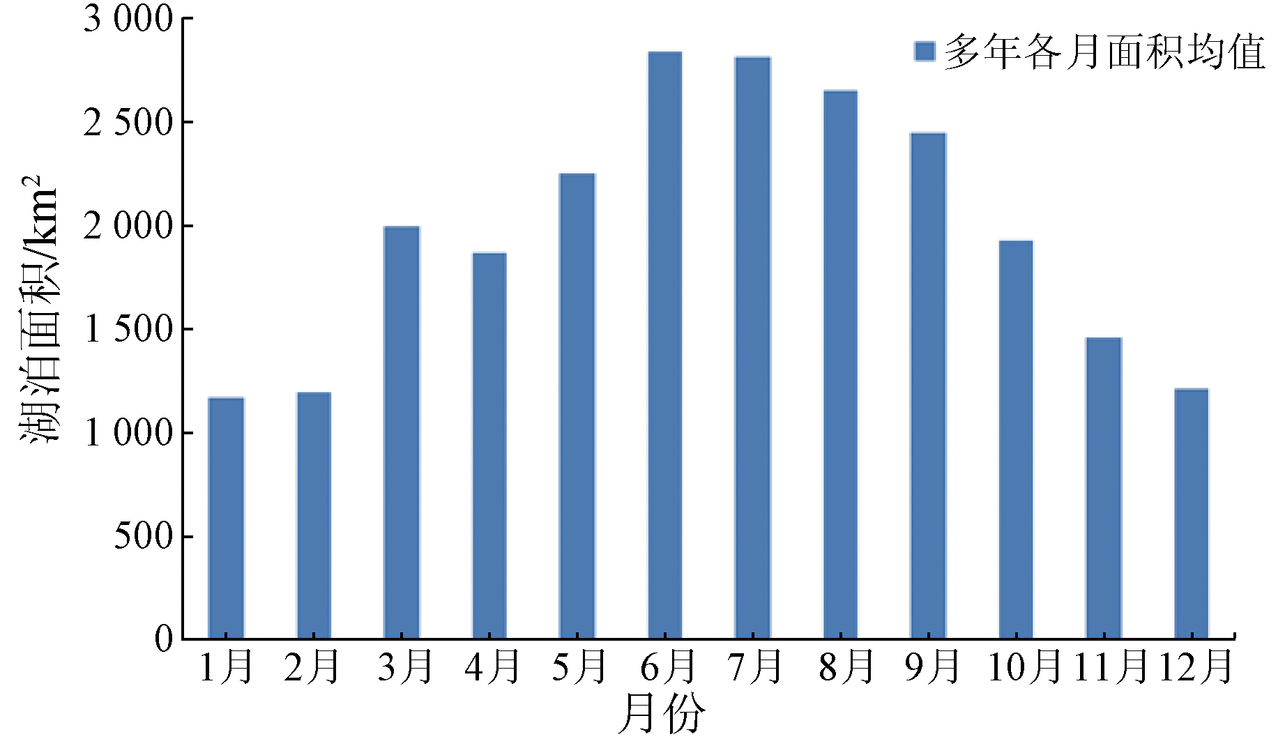
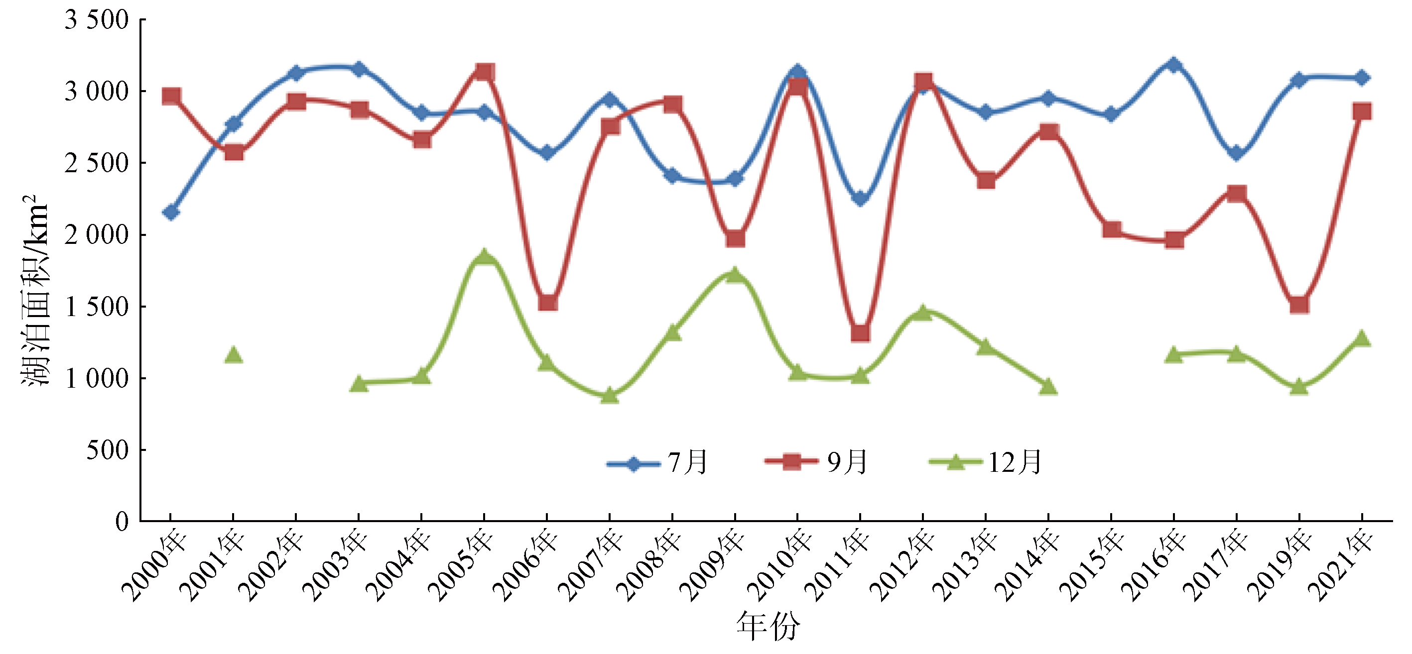
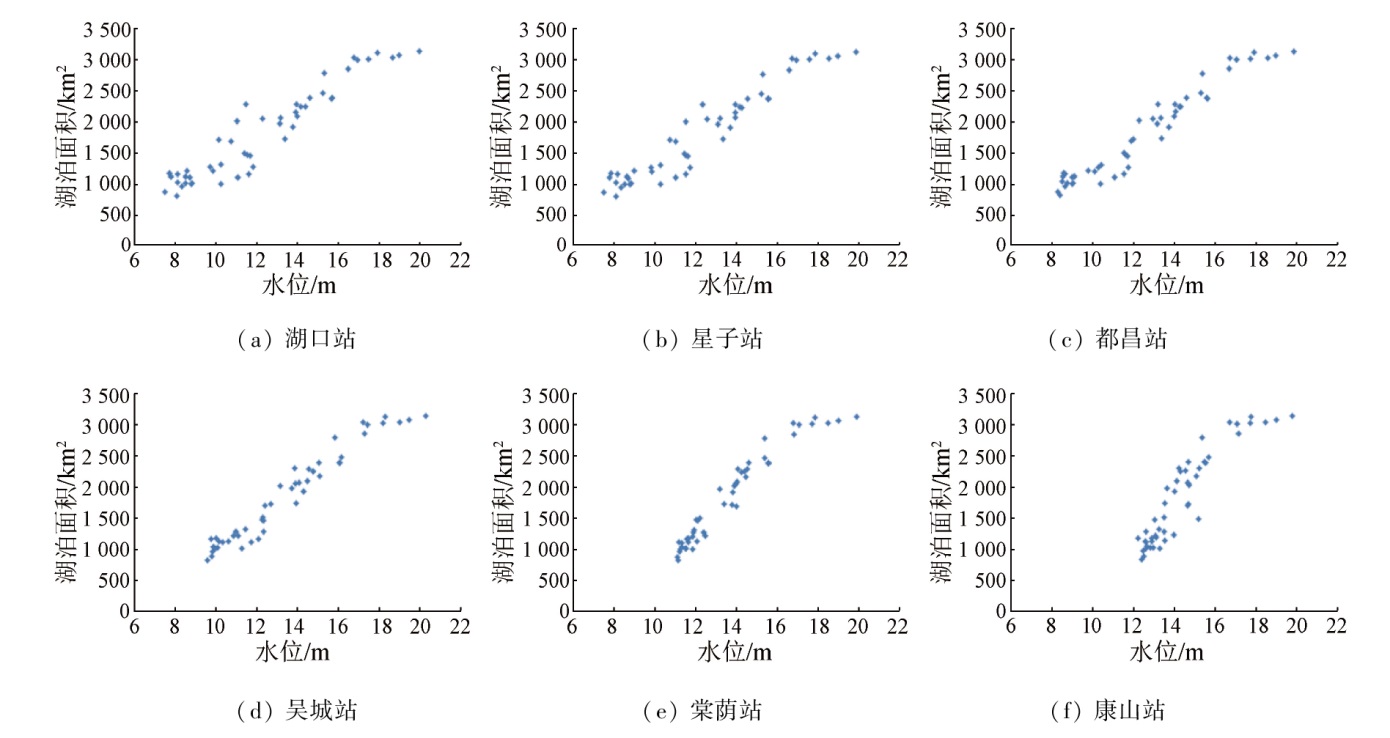
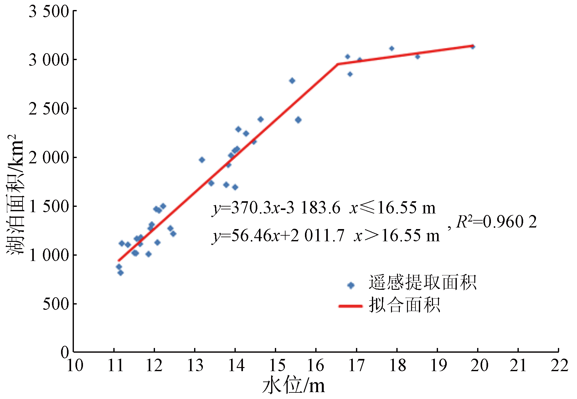
Lakes constitute a crucial part of terrestrial ecosystems. Changes in the water areas of lakes significantly influence environments and human production activities. Poyang Lake, the largest freshwater lake in China, has experienced many floods and droughts in recent years, thus necessitating its dynamic monitoring. With 175-phase Landsat images of Poyang Lake from 2000 to 2021 as the data source, this study comparatively analyzed four water body extraction methods: the normalized difference water index (NDWI), the modified normalized difference water index (MNDWI), the automated water extraction index (AWEI), and the spectrum photometric method (SPM), determining the optimal water body extraction index for Poyang Lake. Moreover, based on the 175-phase area data, this study delved into the inter-annual area variation trend from 2000 to 2021 as well as the intra-annual seasonal variations. Furthermore, it established the area - water level model by combining 50 sets of water level data from 2009 to 2013 and 2017 to 2018. The results show that: ① The AWEI model, outperforming the other three models in the extraction accuracy, was employed for the water body extraction of Poyang Lake; ② The area of Poyang Lake exhibited significant seasonal variations, large inter-annual fluctuations in the wet season, and relatively gentle inter-annual fluctuations in the dry season; ③ The area - water level piecewise linear model of the Tangyin gauging station proved optimal, which can predict the water coverage area based on real-time water level observations in Poyang Lake, compensating for the limitation of visible spectral remote sensing methods in monitoring the lake water coverage during cloudy and rainy weather.
赵辉, 陈振, 冯超帆, 张通, 赵学晶, 张兆旭. 基于Landsat影像的鄱阳湖面积监测及其与水位关系研究[J]. 自然资源遥感, 2024, 36(2): 198-206.
ZHAO Hui, CHEN Zhen, FENG Chaofan, ZHANG Tong, ZHAO Xuejing, ZHANG Zhaoxu. Monitoring of the area of Poyang Lake based on Landsat images and its relationship with the water level. Remote Sensing for Natural Resources, 2024, 36(2): 198-206.
Meng K, Shi X H, Wang E Q, et al. High-altitude salt lake elevation changes and glacial ablation in Central Tibet,2000—2010[J]. Chinese Science Bulletin, 2012, 57(7):571-579.
[3]
Benson L V, Paillet F L. The use of total lake-surface area as an indicator of climatic change:Examples from the Lahontan basin[J]. Quaternary Research, 1989, 32(3):262-275.
[4]
张歆牧. 鄱阳湖湿地生态环境评价[D]. 武汉: 华中师范大学, 2008.
Zhang X M. Evaluation of the ecological environment of Poyang Lake wetland[D]. Wuhan: Central China Normal University, 2008.
Jiang L G. Flood risk and land use change in the wetland restoration area around Poyang Lake,China[D]. Beijing: Institute of Geographic Sciences and Natural Resources Research, CAS, 2006.
[7]
Nie Y, Zhang Y, Ding M, et al. Lake change and its implication in the vicinity of Mt.Qomolangma (Everest),central high Himalayas,1970—2009[J]. Environmental Earth Sciences, 2013, 68(1):251-265.
[8]
Feng L, Hu C M, Chen X L, et al. Satellites capture the drought severity around China’s largest freshwater lake[J]. IEEE Journal of Selected Topics in Applied Earth Observations and Remote Sensing, 2012, 5(4):1266-1271.
[9]
Carroll M L, Townshend J R G, DiMiceli C M, et al. Shrinking lakes of the Arctic:Spatial relationships and trajectory of change[J]. Geophysical Research Letters, 2011, 38(20):L20406.
Li J G, Li J R, Huang S F, et al. The remote sensing monitoring analysis of Chinese Dongting Lake water area variations in last 10 years using Terra/MODIS data time series[J]. Journal of China Institute of Water Resources and Hydropower Research, 2010, 8(3):201-207.
Yu H, Zhang S Q, Li X F, et al. Inland limnetic wetlands water body extraction using TM imagery[J]. Remote Sensing Technology and Application, 2008, 23(3):310-315.
Che X H. Monitoring and analyzing of lake dynamics in Qinghai-Tibet Plateau using remote sensing from 2000 to 2014[D]. Taiyuan: Taiyuan University of Technology, 2015.
[13]
Sokolov M, Storie J L, Henry C J, et al. Semantically-consistent Landsat8 image to Sentinel-2 image translation for alpine areas[J/OL]. arXiv, 2022 (2022-12-22)[2023-02-20]. https://arxiv.org/abs/2212.12056.
[14]
Zhang G Q, Li J L, Zheng G X, et al. Lake-area mapping in the Tibetan Plateau:An evaluation of data and methods[J]. International Journal of Remote Sensing, 2017, 38(3):742-772.
Liu D, Li Y. The calculation of area and storage of Poyang Lake based on remote sensing technology[J]. Remote Sensing Information, 2012, 27(2):57-61.
[16]
McFeeters S K. The use of the Normalized Difference Water Index (NDWI) in the delineation of open water features[J]. International Journal of Remote Sensing, 1996, 17(7):1425-1432.
[17]
Frazier P S, Page K J. Water body detection and delineation with Landsat TM data[J]. Photogrammetric Engineering and Remote Sensing, 2000, 66(12):1461-1467.
[18]
Olmanson L G, Bauer M E, Brezonik P L. A 20-year Landsat water clarity census of Minnesota’s 10,000 lakes[J]. Remote Sensing of Environment, 2008, 112(11):4086-4097.
[19]
Fisher A, Flood N, Danaher T. Comparing Landsat water index methods for automated water classification in eastern Australia[J]. Remote Sensing of Environment, 2016, 175:167-182.
[20]
Li A M, Fan M, Qin G D. Comparative analysis of machine learning algorithms in water extraction[J]. Journal of Physics:Conference Series, 2021, 2076(1):012045.
[21]
Qin P, Cai Y L, Wang X L. Small waterbody extraction with improved U-net using Zhuhai-1 hyperspectral remote sensing images[J]. IEEE Geoscience and Remote Sensing Letters, 2021, 19:5502705.
Li H, Li C A, Zhang L H, et al. Relationship between water level and water area in Poyang Lake based on MODIS image[J]. Quaternary Sciences, 2008, 28(2):332-337.
Liu K Q, Liang Y T, Huang J, et al. Analysis of the variations and influencing factors of area in Dongting Lake based on remote sensing satellite[J]. Chinese Journal of Agrometeorology, 2009, 30(s2):281-284,336.
Zhang N N, Wang W, Wang Y. Estimate the area of the Poyang Lake using satellite remote sensing data and analyze its relationship with water level[J]. Remote Sensing Technology and Application, 2012, 27(6):947-953.
Li P, Feng Z M, Jiang L G, et al. Natural water surface of Poyang Lake monitoring based on remote sensing and the relationship with water level[J]. Journal of Natural Resources, 2013, 28(9):1556-1568.
Zhou Y, Zhang Z X, Wang Y X. Discussion of relationship between water level and area of Poyang Lake[J]. Bulletin of Science and Technology, 2015, 31(11):42-47.
[27]
Feyisa G L, Meilby H, Fensholt R, et al. Automated water extraction index:A new technique for surface water mapping using Landsat imagery[J]. Remote Sensing of Environment, 2014, 140:23-35.
Zhu H F, Jin F, Li R F. Study on regulation and storage function and comprehensive disaster prevention and control of Poyang Lake[M]. Beijing: China Meteorological Press, 2002.
Wang D Z, Wang S M, Huang C. Comparison of Sentinel-2 imagery with Landsat8 imagery for surface water extraction using four common water indexes[J]. Remote Sensing for Land and Resources, 2019, 31(3):157-165.doi:10.6046/gtzyyg.2019.03.20.
Li G W, Yu Z W, Chen J L. Study on the relationship between dynamic level-area and level-volume of Poyang Lake[J]. Jiangxi Hydraulic Science & Technology, 2015, 41(1):21-26,34.
Zeng S L. Analysis of the relationship between water level and lake surface area of Poyang Lake based on EFDC model[D]. Nanchang: Jiangxi Normal University, 2018.
Cai X B. The change analysis of water stage and beach wetland in Poyang Lake with the aid of multi-temporal active and passive remote sensing data[D]. Wuhan: Wuhan University, 2010.
Xu H Q. A Study on information extraction of water body with the modified normalized difference water index(MNDWI)[J]. Journal of Remote Sensing, 2005, 9(5):589-595.
 2024, Vol. 36
  ), 陈振2, 冯超帆1, 张通1, 赵学晶1, 张兆旭3,4(