A multispectral image pansharpening algorithm based on nonsubsampled contourlet transform (NSCT) combined with a guided filter
XU Xinyu1(), LI Xiaojun1,2,3(), GE Junfei1, LI Yikun1,2,3
1. Faculty of Geomatics, Lanzhou Jiaotong University, Lanzhou 730070, China 2. National-Local Joint Engineering Research Center of Technologies and Applications for National Geographic State Monitoring, Lanzhou 730070, China 3. Gansu Provincial Engineering Laboratory for National Geographic State Monitoring, Lanzhou 730070, China
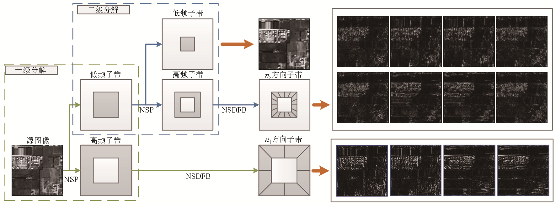
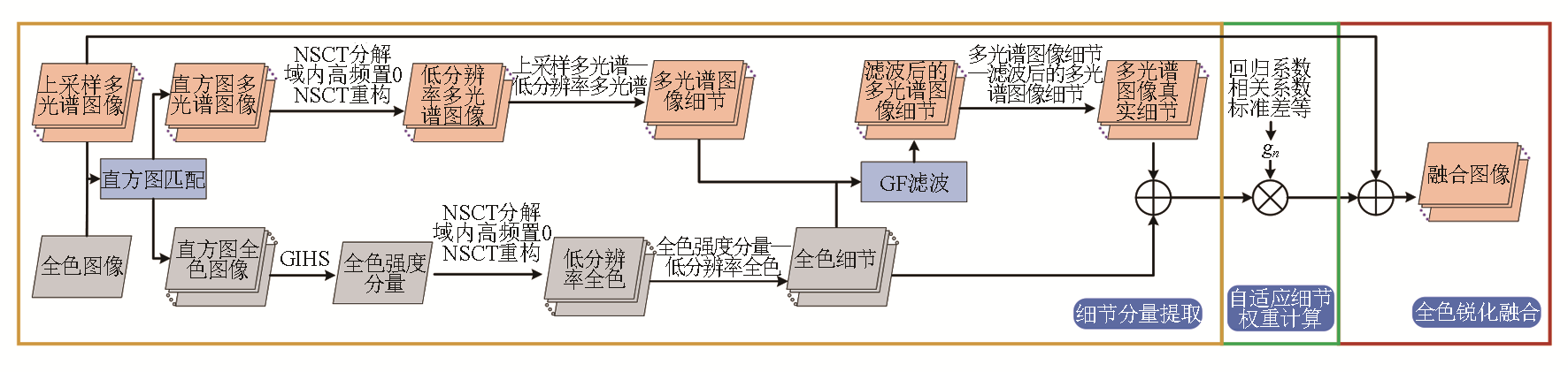
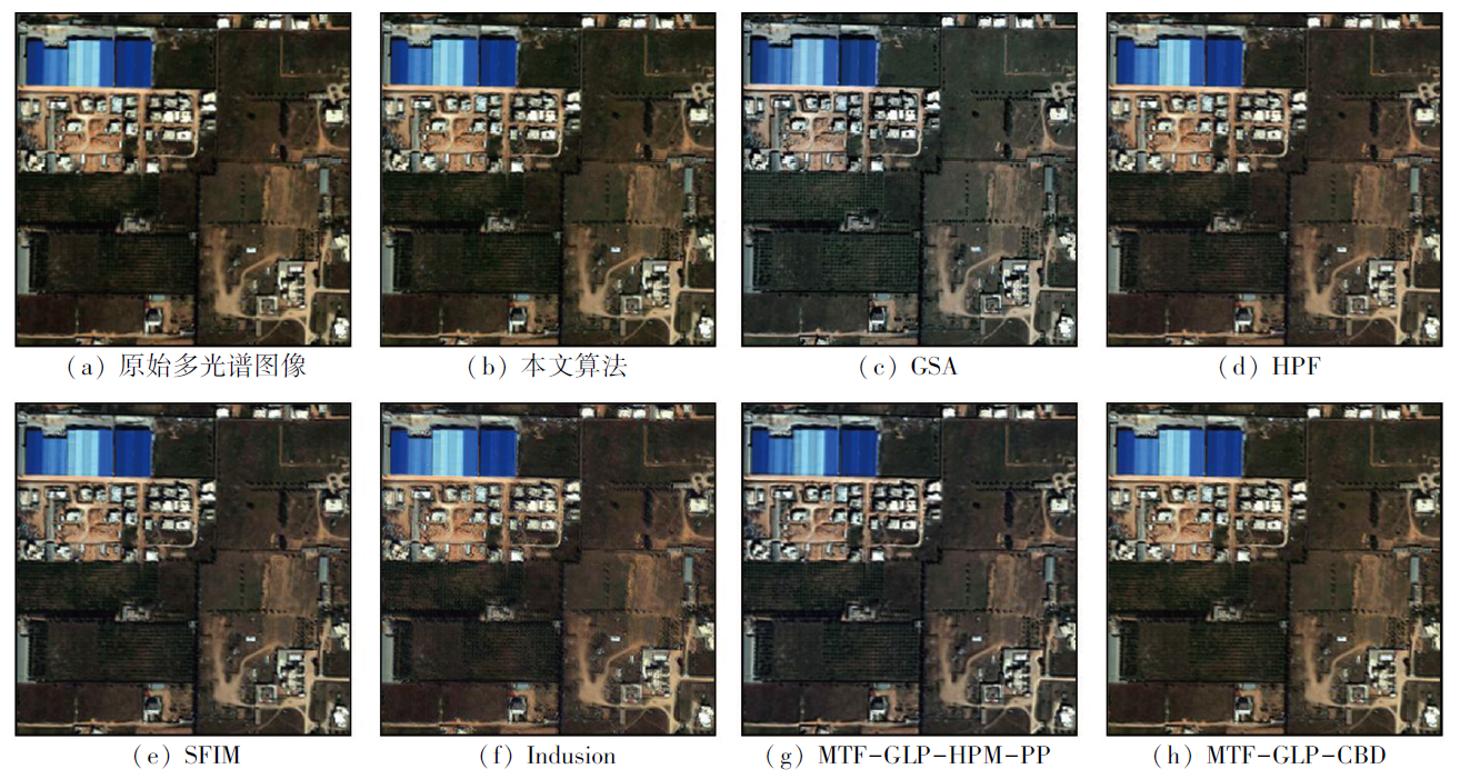
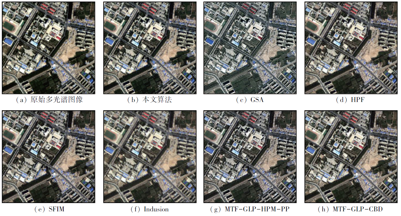
Remote sensing image fusion technology can combine and enhance information from two or more multi-source remote sensing images, making the fused image more accurate and comprehensive. The nonsubsampled contourlet transform (NSCT) is effective in extracting details from high-resolution remote sensing images through multi-scale and multi-directional decomposition, thus achieving image sharpening with high spatial resolution. However, traditional NSCT produces limited high-frequency details and is prone to introduce artifacts such as “ghosting” in fused images. To address this issue, the study proposed a new panchromatic sharpening fusion algorithm for remote sensing images by combining NSCT with a guided filter (GF). Specifically, the promoted algorithm extracted the detail components from histogram-matched images using the multi-scale, multi-direction decomposition and reconstruction properties of the NSCT. Meanwhile, it extracted multi-spectral detail components with panchromatic detail features using GF. Finally, the fused images with high-spatial and high-spectral resolutions were obtained by sharpening based on weighted detail components. The proposed algorithm was proved effective through both subjective and objective evaluations using multiple high-resolution remote sensing datasets.
徐欣钰, 李小军, 盖钧飞, 李轶鲲. 结合NSCT变换和引导滤波的多光谱图像全色锐化算法[J]. 自然资源遥感, 2025, 37(1): 24-30.
XU Xinyu, LI Xiaojun, GE Junfei, LI Yikun. A multispectral image pansharpening algorithm based on nonsubsampled contourlet transform (NSCT) combined with a guided filter. Remote Sensing for Natural Resources, 2025, 37(1): 24-30.
Hu J, Hu P, Wang Z, et al. Spatial dynamic selection network for remote-sensing image fusion[J]. IEEE Geoscience and Remote Sensing Letters, 2021,19:8013205.
[2]
Cao S Y, Hu X J. Dynamic prediction of urban landscape pattern based on remote sensing image fusion[J]. International Journal of Environmental Technology and Management, 2021, 24(1/2):18.
[3]
Xu J, Luo C, Chen X, et al. Remote sensing change detection based on multidirectional adaptive feature fusion and perceptual similarity[J]. Remote Sensing, 2021, 13(15):3053.
[4]
Li H, Song D, Liu Y, et al. Automatic pavement crack detection by multi-scale image fusion[J]. IEEE Transactions on Intelligent Transportation Systems, 2019, 20(6):2025-2036.
Ge J F, Li X J, Zhao H T, et al. Adaptive panchromatic sharpening algorithm with pulse coupled neural network[J]. Science of Surveying and Mapping, 2023, 48(1):60-69.
[6]
Wady S M A, Bentoutou Y, Bengermikh A, et al. A new IHS and wavelet based pansharpening algorithm for high spatial resolution satellite imagery[J]. Advances in Space Research, 2020, 66(7):1507-1521.
[7]
Dadrass Javan F, Samadzadegan F, Mehravar S, et al. A review of image fusion techniques for pan-sharpening of high-resolution satellite imagery[J]. ISPRS Journal of Photogrammetry and Remote Sensing, 2021,171:101-117.
[8]
Wu Z, Huang Y, Zhang K. Remote sensing image fusion method based on PCA and curvelet transform[J]. Journal of the Indian Society of Remote Sensing, 2018, 46(5):687-695.
Zhang T, Liu J, Yang K M, et al. Fusion algorithm for hyperspectral remote sensing image combined with harmonic analysis and gram-schmidt transform[J]. Acta Geodaetica et Cartographica Sinica, 2015, 44(9):1042-1047.
doi: 10.11947/j.AGCS.2015.20140637
Wu Y Q, Wang Z L. Multispectral and panchromatic image fusion using chaotic Bee Colony optimization in NSST domain[J]. Journal of Remote Sensing, 2017, 21(4):549-557.
[11]
Jin H, Wang Y. A fusion method for visible and infrared images based on contrast pyramid with teaching learning based optimization[J]. Infrared Physics & Technology, 2014,64:134-142.
[12]
Do M N, Vetterli M. The contourlet transform:An efficient directional multiresolution image representation[J]. IEEE Transactions on Image Processing:A Publication of the IEEE Signal Processing Society, 2005, 14(12):2091-2106.
[13]
Lim W Q. The discrete shearlet transform:A new directional transform and compactly supported shearlet frames[J]. IEEE Transactions on Image Processing:a Publication of the IEEE Signal Processing Society, 2010, 19(5):1166-1180.
[14]
Singh H, Cristobal G, Blanco S, et al. Nonsubsampled contourlet transform based tone-mapping operator to optimize the dynamic range of diatom shells[J]. Microscopy Research and Technique, 2021, 84(9):2034-2045.
Xu X Y, Li X J, Zhao H T, et al. Pansharpening algorithm of remote sensing images based on by combining NSCT and PCNN[J]. Remote Sensing for Natural Resources.[2023-09-18].http://kns.cnki.net/kcms/detail/10.1759.P.20221102.1831.020.html.
[16]
Cunha A L, Zhou J, Do M N. The nonsubsampled contourlet transform:Theory,design,and applications[J]. IEEE Transactions on Image Processing:A Publication of the IEEE Signal Processing Society, 2006, 15(10):3089-3101.
[17]
He K, Sun J, Tang X. Single image haze removal using dark channel prior[J]. IEEE Transactions on Pattern Analysis and Machine Intelligence, 2011, 33(12):2341-2353.
doi: 10.1109/TPAMI.2010.168
pmid: 20820075
[18]
He K, Sun J, Tang X. Guided image filtering[J]. IEEE Transactions on Pattern Analysis and Machine Intelligence, 2013, 35(6):1397-1409.
doi: 10.1109/TPAMI.2012.213
pmid: 23599054
[19]
Choi J, Yu K, Kim Y. A new adaptive component-substitution-based satellite image fusion by using partial replacement[J]. IEEE Transactions on Geoscience and Remote Sensing, 2011, 49(1):295-309.
Zhang L F, Peng M Y, Sun X J, et al. Progress and bibliometric analysis of remote sensing data fusion methods(1992-2018)[J]. Journal of Remote Sensing, 2019, 23(4):603-619.
[21]
Wald L, Ranchin T, Mangolini M. Fusion of satellite images of different spatial resolutions:Assessing the quality of resulting images[J]. Photogrammetric Engineering and Remote Sensing, 1997, 63(6):691-699.
[22]
Aiazzi B, Baronti S, Selva M. Improving component substitution pansharpening through multivariate regression of MS+Pan data[J]. IEEE Transactions on Geoscience and Remote Sensing, 2007, 45(10):3230-3239.
[23]
Vivone G, Dalla Mura M, Garzelli A, et al. A new benchmark based on recent advances in multispectral pansharpening:Revisiting pansharpening with classical and emerging pansharpening methods[J]. IEEE Geoscience and Remote Sensing Magazine, 2021, 9(1):53-81.
[24]
Vivone G, Alparone L, Chanussot J, et al. A critical comparison among pansharpening algorithms[J]. IEEE Transactions on Geoscience and Remote Sensing, 2015, 53(5):2565-2586.
 2025, Vol. 37
  ), 李小军1,2,3(