An ICM-based adaptive pansharpening algorithm for hyperspectral images
ZHAO Heting1(), LI Xiaojun1,2,3(), XU Xinyu1, GAI Junfei1
1. Faculty of Geomatics, Lanzhou Jiaotong University, Lanzhou 730070, China 2. National-Local Joint Engineering Research Center of Technologies and Applications for National Geographic State Monitoring, Lanzhou 730070, China 3. Gansu Provincial Engineering Laboratory for National Geographic State Monitoring, Lanzhou 730070, China
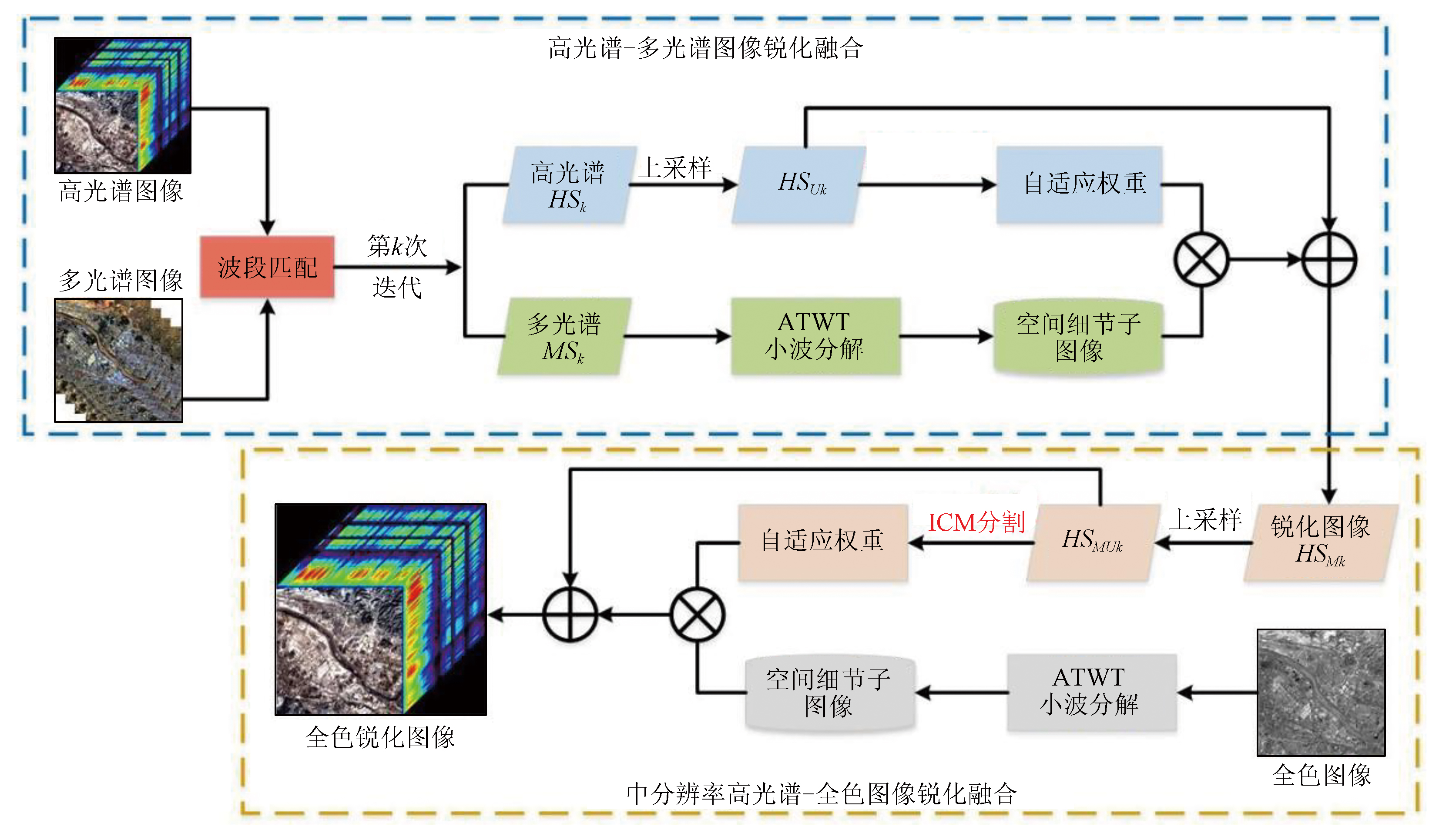
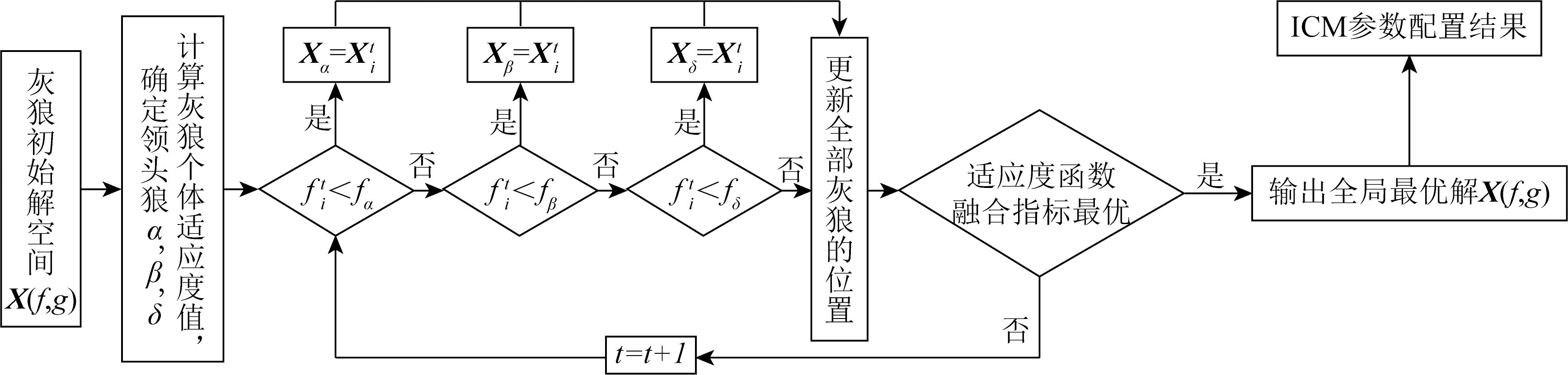
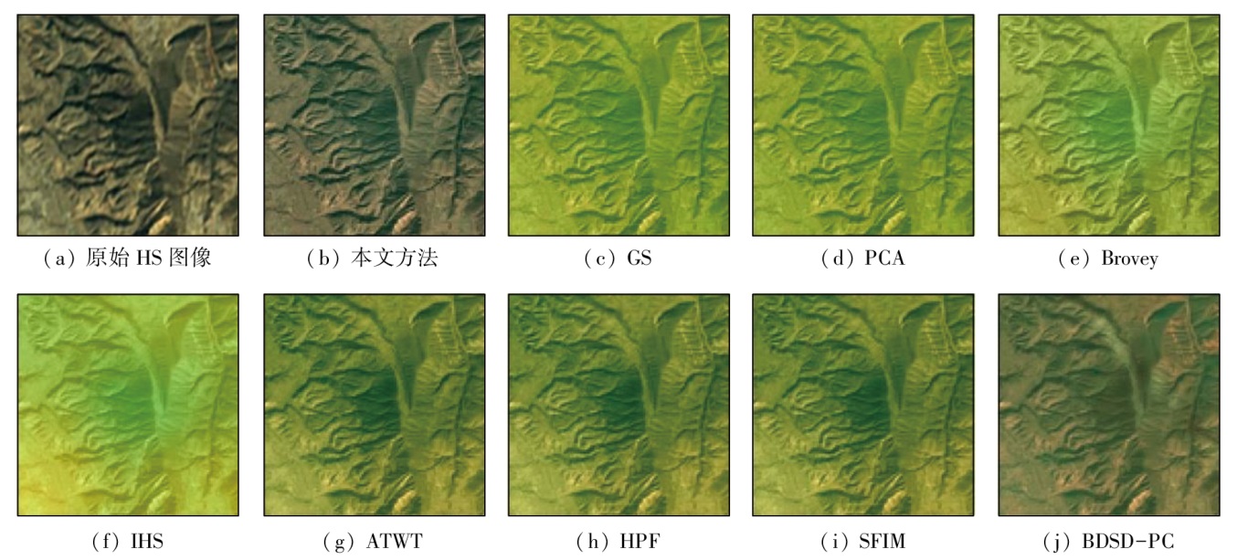
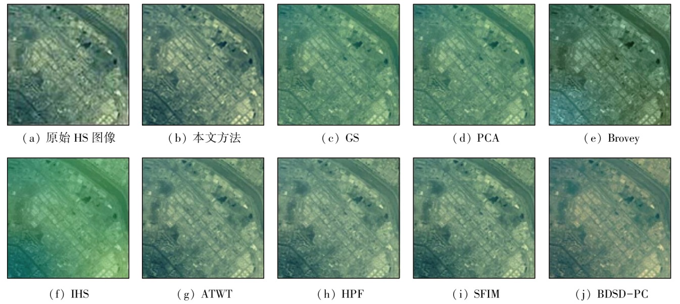
Considering spectral distortion and insufficient texture details in the pansharpening of hyperspectral images, this study proposed an adaptive pansharpening algorithm for hyperspectral images based on the intersecting cortical model (ICM) for image segmentation. First, hyperspectral images were matched and fused with multispectral images with similar spatial resolution. Then, the matching and fusion results were fused with high-resolution panchromatic images, obtaining the fusion results possessing both the high spatial resolution of panchromatic images and the spectral resolution of hyperspectral images. Moreover, the grey wolf optimizer (GWO) was employed in sharpening fusion to adaptively optimize ICM parameters, generating the optimal irregular segmentation regions, thus providing more accurate and comprehensive details and spectral information for hyperspectral images. Finally, experiments were conducted on the proposed algorithm using two hyperspectral datasets from the ZY-1 02D satellite. The experimental results demonstrate that the proposed algorithm manifested the optimal performance in the evaluation indices of spatial details and spectral information, substantiating its effectiveness.
Hong K. Fusion of RGB and hyperspectral images based on super-pixel segmentation[J]. Electronic Technology & Software Engineering, 2020 (3):74-76.
[2]
Ren K, Sun W, Meng X, et al. Fusing China GF-5 hyperspectral data with GF-1,GF-2 and Sentinel-2A multispectral data:Which methods should be used[J]. Remote Sensing, 2020, 12(5):882.
Zhang L F, Zhao X Y, Sun X J, et al. Comparison of fusion methods on GF-5 hyperspectral data[J]. National Remote Sensing Bulletin, 2022, 26(4):632-645.
[4]
Vivone G. Robust band-dependent spatial-detail approaches for panchromatic sharpening[J]. IEEE Transactions on Geoscience and Remote Sensing, 2019, 57(9):6421-6433.
[5]
Restaino R, Vivone G, Dalla Mura M, et al. Fusion of multispectral and panchromatic images based on morphological operators[J]. IEEE Transactions on Image Processing, 2016, 25(6):2882-2895.
doi: 10.1109/TIP.2016.2556944
pmid: 28113904
[6]
Vivone G, Restaino R, Chanussot J. A bayesian procedure for full-resolution quality assessment of pansharpened products[J]. IEEE Transactions on Geoscience and Remote Sensing, 2018, 56(8):4820-4834.
[7]
Vivone G, Restaino R, Mura M D, et al. Contrast and error-based fusion schemes for multispectral image pansharpening[J]. IEEE Geoscience and Remote Sensing Letters, 2014, 11(5):930-934.
[8]
Vivone G. Multispectral and hyperspectral image fusion in remote sensing:A survey[J]. Information Fusion, 2023, 89:405-417.
[9]
Restaino R, Vivone G, Addesso P, et al. Hyperspectral sharpening approaches using satellite multiplatform data[J]. IEEE Transactions on Geoscience and Remote Sensing, 2021, 59(1):578-596.
[10]
Wady S M A, Bentoutou Y, Bengermikh A, et al. A new IHS and wavelet based pansharpening algorithm for high spatial resolution satellite imagery[J]. Advances in Space Research, 2020, 66(7):1507-1521.
[11]
Ghadjati M, Moussaoui A, Boukharouba A. A novel iterative PCA-based pansharpening method[J]. Remote Sensing Letters, 2019, 10(3):264-273.
doi: 10.1080/2150704X.2018.1547443
[12]
Aiazzi B, Baronti S, Selva M. Improving component substitution pansharpening through multivariate regression of MS + Pan data[J]. IEEE Transactions on Geoscience and Remote Sensing, 2007, 45(10):3230-3239.
Hu J W, Wang Z P, Hu P. A review of pansharpening based on deep learning[J]. Remote Sensing for Natural Resources, 2023, 35(1):1-14.doi:10.6046/zrzyyg.2021433.
Li S T, Li C Y, Kang X D. Development status and future prospects of multi-source remote sensing image fusion[J]. National Remote Sensing Bulletin, 2021, 25(1):148-166.
[15]
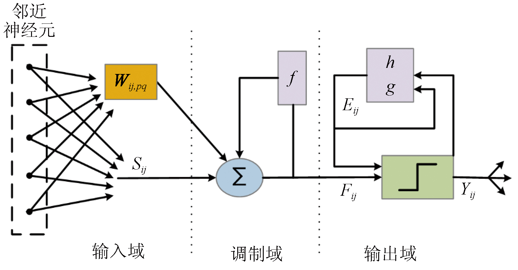
Eckhorn R, Reitboeck H J, Arndt M, et al. Feature linking via stimulus-evoked oscillations:Experimental results from cat visual cortex and functional implications from a network model[C]// International 1989 Joint Conference on Neural Networks.IEEE, 2002:723-730.
Li X J, Yan H W, Yang S W, et al. A fusion algorithm of multispectral remote sensing image and aerial image[J]. Remote Sensing Information, 2019, 34(4):11-15.
Zhang X M, Tu Q, Kang Q, et al. Grey wolf optimization algorithm with double-hunting modes and its application to multi-threshold image segmentation[J]. Journal of Shanxi University (Natural Science Edition), 2016, 39(3):378-385.
[19]
Wang Q, Zhang F, Li X. Optimal clustering framework for hyperspectral band selection[J]. IEEE Transactions on Geoscience and Remote Sensing, 2018, 56(10):5910-5922.
[20]
Li S, Dian R, Fang L, et al. Fusing hyperspectral and multispectral images via coupled sparse tensor factorization[J]. IEEE Transactions on Image Processing, 2018, 27(8):4118-4130.
[21]
Chen Z, Pu H Y, Wang B, et al. Fusion of hyperspectral and multispectral images:A novel framework based on generalization of pan-sharpening methods[J]. IEEE Geoscience and Remote Sensing Letters, 2014, 11(8):1418-1422.
[22]
Lu H, Qiao D, Li Y, et al. Fusion of China ZY-1 02D hyperspectral data and multispectral data:Which methods should be used[J]. Remote Sensing, 2021, 13(12):2354.
 2024, Vol. 36
  ), 李小军1,2,3(