| Orginal Article |
|
 |
|

|
|
|
Spatio-temporal variation of urban heat island effects in Fangchenggang City, Guangxi Zhuang Autonomous Region |
Ming SUN1( ), Min XIE2(), Meihua DING1, Wenlong XU3, Siqi HUANG4, Fei GAO5 ), Min XIE2(), Meihua DING1, Wenlong XU3, Siqi HUANG4, Fei GAO5 |
1. Guangxi Meteorological Disaster Mitigation Institute/Remote Sensing Application and Validation Base of National Satellite Meteorological Center, Nanning 530022,China
2. Guangxi Climate Center, Nanning 530022,China
3. Fangchenggang Meteorological Bureau, Fangchenggang 538001, China
4. School of Geography and Remote Sensing, Nanjing University of Information & Technology, Nanjing 210044, China;
5. Flood Control and Drought Relief Office of Jiangsu Province, Nanjing 210029, China |
|
|
|
|
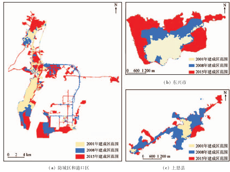
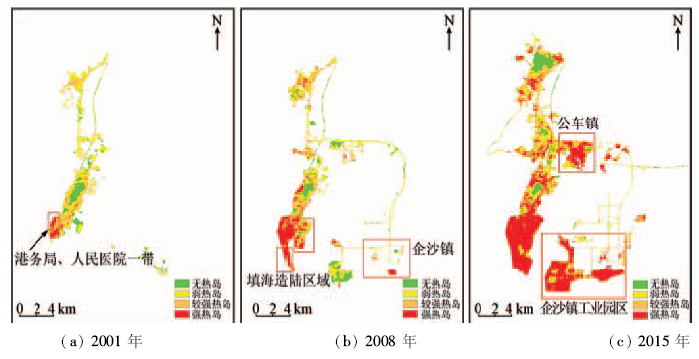
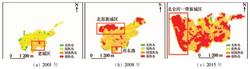
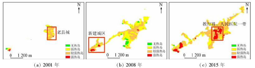
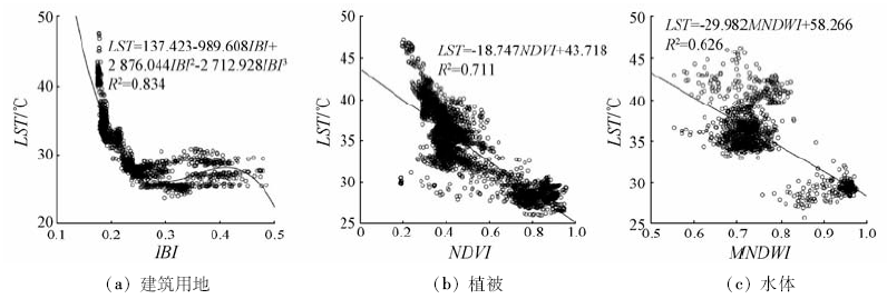
Abstract To study the spatio-temporal variation of urban heat island effects in Fangchenggang City from 2001 to 2015,the authors used the remote sensing methods to monitor the variation characteristics of urban heat island effects in Fangchenggang City for a period of 15 years. The land surface temperature(LST)was retrieved using remote sensing images(Landsat5 TM and Landsat8 OLI) acquired in three periods of 2001, 2008 and 2015. Then, both urban heat island intensity and urban-heat-island ratio index were constructed to analyze the evolution characteristics of heat island effect in the past 15 years from three aspects: the space-time distribution and area variation of heat island intensity, the development characteristics of urban-heat-island ratio index and the influence of underlying surface condition on heat island effect. Some conclusions have been reached: ① Urban area exhibits a trend of rapid expansion in the study area. ② The urban heat island intensity increases year by year, especially in Gangkou District, where annual growth rate reaches 26.72%. ③ The urban-heat-island ratio index is rising year by year in all districts, among which, Dongxing reaches the highest value of 0.62. ④ Cooling effects are obviously for both urban green space and water body, but the operating distance and cooling amplitude of water body are larger than those of green space. However, the proportion of urban vegetation and water of the study area is markedly low. The research results may provide scientific and reasonable proposals for Fangchenggang government's aim of reaching the goal of creating a national garden city.
|
| Keywords
Fangchenggang
land surface temperature(LST)
heat island intensity
urban-heat-island ratio index
|
|
|
|
Issue Date: 08 February 2018
|
|
|
| [1] |
沈立新,鲍淳松.关于城市热岛问题的综述[J].浙江林业科技,2000,20(3):89-92.
|
| [1] |
Shen L X,Bao C S.Summary on urban heat island[J].Journal of Zhejiang Forestry Science and Technology,2000,20(3):89-92.
|
| [2] |
陈健,杨旭媛.基于ASTER数据的城市热环境遥感监测研究[J].国土资源遥感,2011,23(3):100-105.doi:10.6046/gtzyyg.2011.03.18.
|
| [2] |
Chen J,Yang X Y.A study of remote sensing monitoring of urban thermal environment based on ASTER data[J].Remote Sensing for Land and Resources,2011,23(3):100-105.doi:10.6046/gtzyyg.2011.03.18.
|
| [3] |
杨可明,周玉洁,齐建伟,等.城市不透水面及地表温度的遥感估算[J].国土资源遥感,2014,26(2):134-139.doi:10.6046/gtzyyg.2014.02.22.
|
| [3] |
Yang K M,Zhou Y J,Qi J W,et al.Remote sensing estimating of urban impervious surface area and land surface temperature[J].Remote Sensing for Land and Resources,2014,26(2):134-139.doi:10.6046/gtzyyg.2014.02.22.
|
| [4] |
林学椿,于淑秋.北京地区气温的年代际变化和热岛效应[J].地球物理学报,2005,48(1):39-45.
|
| [4] |
Lin X C,Yu S Q.Interdecadal changes of temperature in the Beijing region and its heat island effect[J].Chinese Journal of Geophysics,2005,48(1):39-45.
|
| [5] |
王艳慧,肖瑶.北京市1989-2010年地表温度时空分异特征分析[J].国土资源遥感,2014,26(3):146-152.doi:10.6046/gtzyyg.2014.03.24.
|
| [5] |
Wang Y H,Xiao Y.A tempora1-spatia1variation ana1ysis of 1and surface temperature in Beijing[J].Remote Sensing for Land and Resources,2014,26(3):146-152.doi:10.6046/gtzyyg.2014.03.24.
|
| [6] |
杨丽萍,孔金玲,郭玉芳,等.西安城区地表温度的遥感反演与时空演变分析[J].兰州大学学报(自然科学版),2015,51(3):388-396.
|
| [6] |
Yang L P,Kong J L,Guo Y F,et al.Inversion and temperal-spatial evolution analysis of land surface temperature in urban Xi’an based on remote sensing data[J].Journal of Lanzhou University(Natural Sciences),2015,51(3):388-396.
|
| [7] |
薛晓娟,孟庆岩,王春梅,等.北京市热岛效应时空变化的HJ-1B监测分析[J].地球信息科学学报,2012,14(4):474-480.
|
| [7] |
Xue X J,Men Q Y,Wang C M,et al.Monitoring spatio-temporal changes of heat island effect in Beijing based on HJ-1B[J].Journal of Geo-Information Science,2012,14(4):474-480.
|
| [8] |
王猛猛,周志民,张兆明,等.基于TM数据的合肥市城市热岛效应研究[J].科学技术与工程,2014,14(33):80-85.
|
| [8] |
Wang M M,Zhou Z M,Zhang Z M,et al.Research on the urban heat island effect of Hefei based on Landsat TM data[J].Science Technology and Engineering,2014,14(33):80-85.
|
| [9] |
杨槐. 从Landsat8影像反演地表温度的劈窗算法研究[J].测绘地理信息,2014,39(4):73-77.
|
| [9] |
Yang H.Research of split-window algorithm for retrieval of land surface temperature from Landsat8[J].Journal of Geomatics,2014,39(4):73-77.
|
| [10] |
袁飞. GIS在城市景观规划设计的应用——以广西防城港市为例[D].杨凌:西北农林科技大学,2012.
|
| [10] |
Yuan F.Application of GIS to Urban Landscape Design:A case of Fangchenggang City,Guangxi[D].Yangling:Northwest A&F University,2012.
|
| [11] |
徐涵秋. 一种基于指数的新型遥感建筑用地指数及其生态环境意义[J].遥感技术与应用,2007,22(3):301-308.
|
| [11] |
Xu H Q.A new index-based built-up index(IBI) and its eco-environmental significance[J].Remote Sensing Technology and Application,2007,22(3):301-308.
|
| [12] |
徐涵秋,杜丽萍.遥感建筑用地信息的快速提取[J].地球信息科学报,2010,12(4):574-578.
|
| [12] |
Xu H Q,Du L P.Fast extraction of built-up land information from remote sensing imagery[J].Journal of Geo-Information Science,2010,12(4):574-578.
|
| [13] |
Huete A R.A Soil-adjusted vegetation index(SAVI)[J].Remote Sensing of Environment,1988,25(3):295-309.
|
| [14] |
覃志豪,李文娟,徐斌,等.陆地卫星TM6波段范围内地表比辐射率的估计[J].国土资源遥感,2004,16(3):28-32,36,41.doi:10.6046/gtzyyg.2004.03.07.
|
| [14] |
Qin Z H,Li W J,Xu B,et al.The estimation of land surface emissivity for Landsat TM6[J].Remote Sensing for Land and Resources,2004,16(3):28-32,36,41.doi:10.6046/gtzyyg.2004.03.07.
|
| [15] |
蒋大林,匡鸿海,曹晓峰,等.基于Landsat8的地表温度反演算法研究——以滇池流域为例[J].遥感技术与应用,2015,30(3):448-454.
|
| [15] |
Jiang D L,Kuang H H,Cao X F,et al.Study of land surface temperature retrieval based on Landsat8-with the sample of Dianchi Lake basin[J].Remote Sensing Technology and Application,2015,30(3):448-454.
|
| [16] |
管菁菁,查良松.合肥市城市热环境的空间变化及其驱动力分析[J].安徽师范大学学报(自然科学版),2012,35(1):56-62.
|
| [16] |
Guan J J,Zha L S.Analysis of space change and its driving force of urban thermal environment of Hefei[J].Journal of Anhui Normal University(Natural Science),2012,35(1):56-62.
|
| [17] |
毛克彪,施建成,覃志豪,等.一个针对ASTER数据同时反演地表温度和比辐射率的四通道算法[J].遥感学报,2006,10(4):593-599.
|
| [17] |
Mao K B,Shi J C,Qin Z H,et al.A four-channel algorithm for retrieving land surface temperature and emissivity from ASTER data[J].Journal of Remote Sensing,2006,10(4):593-599.
|
| [18] |
吴志刚,江滔,樊艳磊,等.基于Landsat8数据的地表温度反演及分析研究——以武汉市为例[J].工程地球物理学报,2016,13(1):135-142.
|
| [18] |
Wu Z G,Jiang T,Fan Y L,et al.Land surface temperature retrieval and result analysis based on Landsat8 data in Wuhan City[J].Chinese Journal of Engineering Geophysics,2016,13(1):135-142.
|
| [19] |
李柏延,任志远,李瑞宗,等.西安市地表温度反演及城市热岛强度定量化研究[J].资源科学,2014,36(12):2631-2636.
|
| [19] |
Li B Y,Ren Z Y,Li R Z,et al.Urban heat island intensity quantitative inversion and city land surface temperatures in Xi’an[J].Resources Science,2014,36(12):2631-2636.
|
| [20] |
Qin Z H,Dall’Olmo G,Karnieli A.Derivation of split window algorithm and its sensitivity analysis for retrieving land surface temperature from NOAA-advanced very high resolution radiometer data[J].Journal of Geophysical Research,2001,106(D19):22655-22670.
|
| [21] |
Franc G B,Cracknell A P.Retrieval of land and sea surface temperature using NOAA-11 AVHRR data in north-eastern Brazil[J].International Journal of Remote Sensing,1994,15(8):1695-1712.
|
| [22] |
毛克彪,唐华俊,周清波,等.用辐射传输方程从MODIS数据中反演地表温度的方法[J].兰州大学学报(自然科学版),2007,43(4):12-17.
|
| [22] |
Mao K B,Tang H J,Zhou Q B,et al.Retrieving land surface temperature from MODIS data by using radiance transfer equation[J].Journal of Lanzhou University(Natural Sciences),2007,43(4):12-17.
|
| [23] |
叶彩华,刘勇洪,刘伟东,等.城市地表热环境遥感监测指标研究及应用[J].气象科技,2011,39(1):95-101.
|
| [23] |
Ye C H,Liu Y H,Liu W D,et al.Research on urban surface heat environment monitoring indexes and its application[J].Meteorological Science and Technology,2011,39(1):95-101.
|
| [24] |
Peng S S,Piao S L,Ciais P,et al.Surface urban heat island across 419 global big cities[J].Environmental Science & Technology,2012,46(2):696-703.
|
| [25] |
徐涵秋,陈本清.不同时相的遥感热红外图像在研究城市热岛变化中的处理方法[J].遥感技术与应用,2003,18(3):129-133.
|
| [25] |
Xu H Q,Chen B Q.An image processing technique for the study of urban heat island changes using different seasonal remote sensing data[J].Remote Sensing Technology and Application,2003,18(3):129-133.
|
|
Viewed |
|
|
|
Full text
|
|
|
|
|
Abstract
|
|
|
|
|
Cited |
|
|
|
|
| |
Shared |
|
|
|
|
| |
Discussed |
|
|
|
|
 2018,
Vol. 30
2018,
Vol. 30