|
|
 |
|

|
|
|
A multiscale study of thermal environment pattern in Lanzhou-Xining agglomeration |
Jinghu PAN1( ), Leilei DONG1, Nayun WANG2, Zijin YANG3 ), Leilei DONG1, Nayun WANG2, Zijin YANG3 |
1. College of Geographic and Environmental Science, Northwest Normal University, Lanzhou 730070, China
2. School of Geographic Science, Nanjing Normal University, Nanjing 210023, China
3. Yunnan Map World Information Technology Stock Co., Ltd., Kunming 650034,China |
|
|
|
|
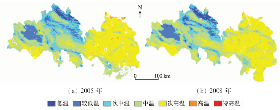
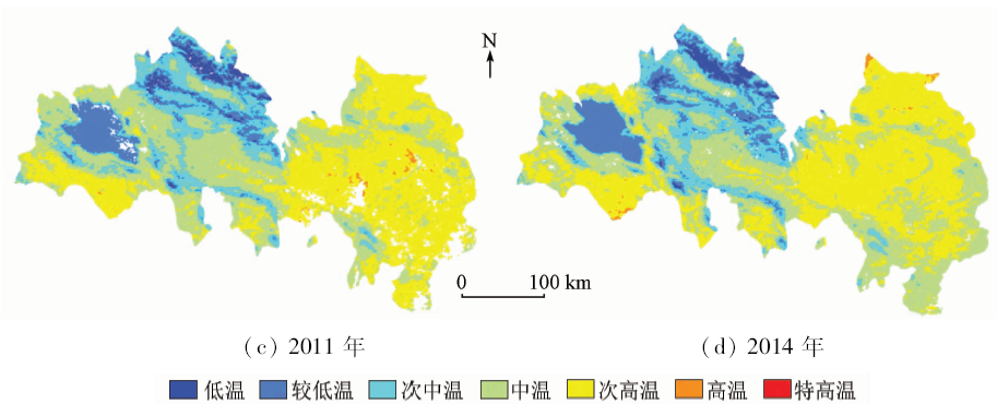
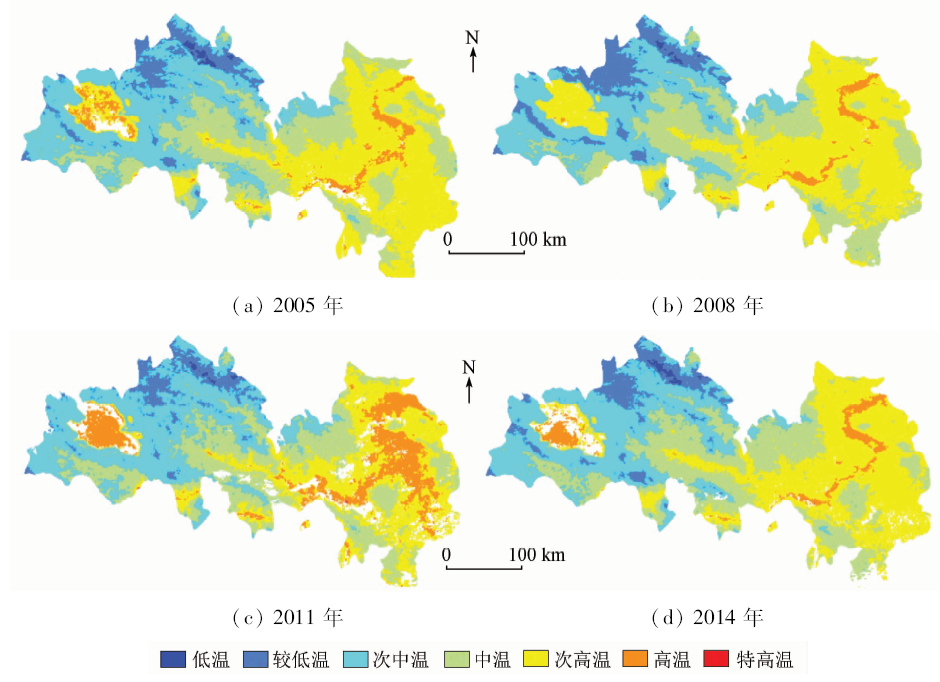
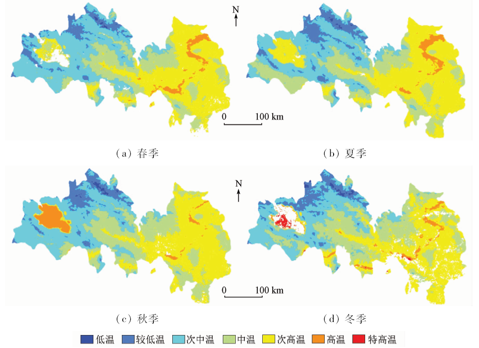
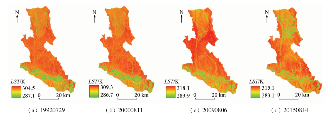
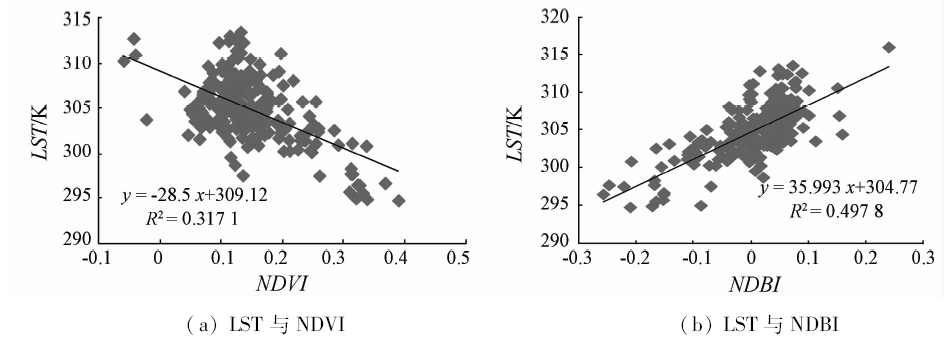
Abstract The study of the changing pattern of urban thermal environment from different spatial scales can provide a scientific reference for the construction of urban human settlements. On the basis of MODIS and Landsat TM/OLI/TIRS data, land surface temperature is retrieval. Spatial pattern of thermal field in Lanzhou-Xining agglomeration (LXA) was analyzed from macro scale and micro scale. Diurnal variation, seasonal variation, and annual variation of urban heat island effect of LXA were explored. The heat island ratio index was introduced to describe the variation characteristics of thermal field pattern in LXA from 1992 to 2015. The results show that, on the large scale, there is no obvious urban heat island effect in LXA, whereas the spatial pattern of urban heat island effect in internal areas of central urban region of Lanzhou and Xining-Haidong changed greatly from 1992 to 2015. The urban sprawl had a spatial consistency with the urban heat island extension. Specifically, the heat island ratio index first increased and then decreased in central urban area of Lanzhou, whereas the heat island ratio index continuously increased significantly in central urban area of Xining-Haidong. As a typical valley agglomeration, the temperature of central cities was lower than that of surrounding loess hilly regions. The main influence factors were vegetation and the duration and amount of solar radiation. It seems that the land surface temperature is negatively correlated with normalized difference vegetation index(NDVI) and positively correlated with normalized difference building index(NDBI).
|
| Keywords
urban heat island
heat island effect
valley city
Lanzhou-Xining agglomeration.
|
|
|
|
Issue Date: 30 May 2018
|
|
|
| [1] |
Quan J L, Chen Y H, Zhan W F , et al. Multi-temporal trajectory of the urban heat island centroid in Beijing,China based on a Gaussian volume model[J]. Remote Sensing of Environment, 2014,149:33-46.
doi: 10.1016/j.rse.2014.03.037
url: http://linkinghub.elsevier.com/retrieve/pii/S0034425714001394
|
| [2] |
袁家冬, 周筠, 黄伟 . 我国都市圈理论研究与规划实践中的若干误区[J]. 地理研究, 2006,25(1):112-120.
doi: 10.3321/j.issn:1000-0585.2006.01.014
url: http://www.cqvip.com/Main/Detail.aspx?id=21191649
|
| [2] |
Yuan J D, Zhou Y, Huang W . Several long-standing mistaken ideas in the theoretical studies and planning practices of Chinese metropolitan regions[J]. Geographical Research, 2006,25(1):112-120.
|
| [3] |
Jiménez-Muñoz J C,Sobrino J A,Skoković D ,et al.Land surface temperature retrieval methods from Landsat-8 thermal infrared sensor data [J]. IEEE Geoscience and Remote Sensing Letters, 2014,11(10):1840-1843.
doi: 10.1109/LGRS.2014.2312032
url: http://ieeexplore.ieee.org/document/6784508/
|
| [4] |
Wang J, Zhan Q M, Guo H G , et al. Characterizing the spatial dynamics of land surface temperature-impervious surface fraction relationship[J]. International Journal of Applied Earth Observation and Geoinformation, 2015,45:55-65.
doi: 10.1016/j.jag.2015.11.006
url: http://www.sciencedirect.com/science/article/pii/S0303243415300520
|
| [5] |
贾伟, 高小红 . 河谷型城市热岛空间分布格局演变及对策——以西宁市区为例[J]. 地球信息科学学报, 2014,16(4):592-601.
doi: 10.3724/SP.J.1047.2014.00592
url: http://www.cqvip.com/QK/86408A/201404/50156280.html
|
| [5] |
Jia W, Gao X H . Analysis of urban heat island environment in a valley city for policy formulation:A case study of Xining City in Qinghai Province of China[J]. Journal of Geo-Information Science, 2014,16(4):592-601.
|
| [6] |
Şahin M, Yıldız B Y, Şenkal O , et al. Modelling and remote sensing of land surface temperature in Turkey[J]. Journal of the Indian Society of Remote Sensing, 2012,40(3):399-409.
doi: 10.1007/s12524-011-0158-3
url: http://link.springer.com/10.1007/s12524-011-0158-3
|
| [7] |
Wu H, Ye L P, Shi W Z , et al. Assessing the effects of land use spatial structure on urban heat islands using HJ-1B remote sensing imagery in Wuhan,China[J]. International Journal of Applied Earth Observation and Geoinformation, 2014,32:67-78.
doi: 10.1016/j.jag.2014.03.019
url: http://linkinghub.elsevier.com/retrieve/pii/S0303243414000774
|
| [8] |
Santamouris M . Cooling the cities:A review of reflective and green roof mitigation technologies to fight heat island and improve comfort in urban environments[J]. Solar Energy, 2014,103:682-703.
doi: 10.1016/j.solener.2012.07.003
url: http://linkinghub.elsevier.com/retrieve/pii/S0038092X12002447
|
| [9] |
Pan J H . Area delineation and spatial-temporal dynamics of urban heat island in Lanzhou City,China using remote sensing imagery[J]. Journal of the Indian Society of Remote Sensing, 2016,44(1):111-127.
doi: 10.1007/s12524-015-0477-x
url: http://link.springer.com/10.1007/s12524-015-0477-x
|
| [10] |
贾宝全, 邱尔发 . 基于TM卫星遥感影像的西安市城市热岛效应变化分析[J]. 干旱区研究, 2013,30(2):347-355.
url: http://d.wanfangdata.com.cn/Periodical/ghqyj201302024
|
| [10] |
Jia B Q, Qiu E F . Dynamic change of urban heat island effect in Xi’an based on TM images[J]. Arid Zone Research, 2013,30(2):347-355.
|
| [11] |
Chavez P S J .Image-based atmospheric corrections-revisited and improved[J]. Photogrammetric Engineering and Remote Sensing, 1996,62(1):1025-1036.
doi: 10.1016/0031-0182(96)00019-3
url: http://ci.nii.ac.jp/naid/80009209429
|
| [12] |
覃志豪 , Zhang M H, Karnieli A, 等. 用陆地卫星TM6数据演算地表温度的单窗算法[J]. 地理学报, 2001,56(4):456-466.
|
| [12] |
Qin Z H, Zhang M H, Karnieli A , et al. Mono-window algorithm for retrieving land surface temperature from Landsat TM6 data[J]. Acta Geographica Sinica, 2001,56(4):456-466.
|
| [13] |
潘竟虎, 张伟强 . 张掖绿洲冷岛效应时空格局的遥感分析[J]. 干旱区研究, 2010,27(4):481-486.
url: http://www.cqvip.com/QK/94330X/201004/34439404.html
|
| [13] |
Pan J H, Zhang W Q . Remote sensing analysis of the spatial-temporal pattern of “cold island” effect of Zhangye Oasis[J]. Arid Zone Research, 2010,27(4):481-486.
|
| [14] |
毛克彪, 覃志豪, 施建成 , 等. 针对MODIS影像的劈窗算法研究[J]. 武汉大学学报(信息科学版), 2005,30(8):703-707.
doi: 10.3321/j.issn:1671-8860.2005.08.011
url: http://d.wanfangdata.com.cn/Periodical/whchkjdxxb200508011
|
| [14] |
Mao K B, Qin Z H, Shi J C , et al. The research of split-window algorithm on the MODIS[J]. Geomatics and Information Science of Wuhan University, 2005,30(8):703-707.
|
| [15] |
李瑶, 潘竟虎 . 基于Landsat 8劈窗算法与混合光谱分解的城市热岛空间格局分析——以兰州市中心城区为例[J]. 干旱区地理, 2015,38(1):111-119.
url: http://d.wanfangdata.com.cn/Periodical/ghqdl201501015
|
| [15] |
Li Y, Pan J H . Spatial pattern on urban heat environment using split window algorithm and spectral mixture analysis based on Landsat 8 images:A case of Lanzhou City[J]. Arid Land Geography, 2015,38(1):111-119.
|
| [16] |
徐涵秋, 陈本清 . 不同时相的遥感热红外图像在研究城市热岛变化中的处理方法[J]. 遥感技术与应用, 2003,18(3):129-133.
|
| [16] |
Xu H Q, Chen B Q . An image processing technique for the study of urban heat island changes using different seasonal remote sensing data[J]. Remote Sensing Technology and Application, 2003,18(3):129-133.
|
| [17] |
蒲禹君, 蒲金涌 . 西北中等城市热岛效应变化特征——以天水市为例[J]. 环境工程技术学报, 2011,1(5):376-382.
doi: 10.3969/j.issn.1674-991X.2011.05.063
url: http://d.wanfangdata.com.cn/Periodical/hjgcjsxb201105002
|
| [17] |
Pu Y J, Pu J Y . Variation of urban heat island characteristics at medium-sized city in the Northwest:A case of Tianshui[J]. Journal of Environmental Engineering Technology, 2011,1(5):376-382.
|
|
Viewed |
|
|
|
Full text
|
|
|
|
|
Abstract
|
|
|
|
|
Cited |
|
|
|
|
| |
Shared |
|
|
|
|
| |
Discussed |
|
|
|
|
 2018,
Vol. 30
2018,
Vol. 30