|
|
|
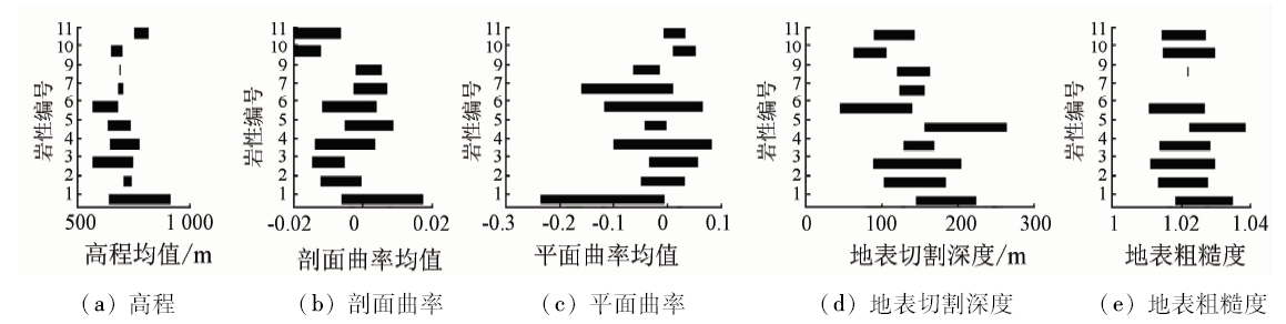
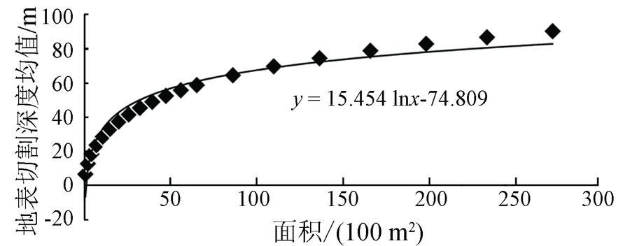
Abstract Lithologic identification and classification can provide important basic information for regional geological survey and mineral resource exploration. Topographic variables constitute the quantitative parameters of digital expression for topography, and are very important in improving the accuracy. Based on the classification validity and correlation of 10 topographic variables such as elevation, slope, profile curvature, surface roughness, and surface cutting depth in the known lithologic area, the authors screened the topographic variables and used the variables under the best scale for the classification of lithology. The result shows that the combination of elevation, profile curvature, surface cutting depth, surface roughness and plane curvature is very useful and, in terms of the capability of identification, each variable has the corresponding lithology. The adding of the best terrain variables combination to fully express terrain characteristics in identifying each type of lithology is helpful to improving the recognition and classification of lithology.
|
| Keywords
geological lithology classification
topography
topographic variables
mean change point analysis
unsupervised classification
|
|
|
|
Corresponding Authors:
Jun PAN
E-mail: 1362258925@qq.com;Panj@jlu.edu.cn
|
|
Issue Date: 30 May 2018
|
|
|
| [1] |
余海阔, 李培军 . 运用LANDSAT ETM+和ASTER数据进行岩性分类[J]. 岩石学报, 2010,26(1):345-351.
|
| [1] |
Yu H K, Li P J . Lithologic mapping using LANDSAT ETM+ and ASTER data[J]. Acta Petrologica Sinica, 2010,26(1):345-351.
|
| [2] |
王晓东 . 水系提取方法研究及其地质意义[D]. 长春:吉林大学, 2015.
|
| [2] |
Wang X D . The Research of Drainage Extraction Method and Its Geological Significance[D]. Changchun:Jinlin University, 2015.
|
| [3] |
于亚凤, 杨金中, 陈圣波 , 等. 基于光谱指数的遥感影像岩性分类[J]. 地球科学, 2015,40(8):1415-1419.
|
| [3] |
Yu Y F, Yang J Z, Chen S B , et al. Lithologic classification from remote sensing images based on spectral index[J]. Earth Science, 2015,40(8):1415-1419.
|
| [4] |
黄颖端, 李培军, 李争晓 . 基于地统计学的图像纹理在岩性分类中的应用[J]. 国土资源遥感, 2003,15(3):45-49.doi: 10.6046/gtzyyg.2003.03.11
doi: 10.3969/j.issn.1001-070X.2003.03.011
url: http://d.wanfangdata.com.cn/Periodical/gtzyyg200303011
|
| [4] |
Huang Y D, Li P J, Li Z X . The application of geostatistical image texture to remote sensing lithological classification[J]. Remote Sensing for Land and Resources, 2003,15(3):45-49.doi: 10.6046/gtzyyg.2003.03.11
|
| [5] |
曾德耀 . 基于最佳地形因子组合的地貌形态类型划分研究[D]. 重庆:重庆交通大学, 2015.
|
| [5] |
Zeng D Y . Classification of Relief Form Based on the Best Terrain Factor Combination[D]. Chongqing:Chongqing Jiaotong University, 2015.
|
| [6] |
杨晏立, 何政伟, 杨斌 , 等. 最佳因子复合的四川省地貌类型自动划分[J].陕西理工学院学报(自然科学版)2009, 25(4):74-79.
doi: 10.3969/j.issn.1673-2944.2009.04.015
url: http://d.wanfangdata.com.cn/Periodical_sxgxyxb200904015.aspx
|
| [6] |
Yang Y L, He Z W, Yang B , et al. Automatic classification of landform types in Sichuan Province with the optimum factors complex[J].Journal of Shaanxi University of Technology(Natural Science Edition)2009, 25(4):74-79.
|
| [7] |
姜莎莎, 李培军 . 基于ASTER图像和地形因子的岩性单元分类——以新疆木垒地区为例[J]. 地球信息科学学报, 2011,13(6):825-832.
doi: 10.3724/SP.J.1047.2011.00825
url: 研究点分析
|
| [7] |
Jiang S S, Li P J . Lithologic unit mapping using ASTER data and topographic variables:A case study of Mulei area of XinJiang[J]. Journal of Geo-Information Science, 2011,13(6):825-832.
|
| [8] |
Grebby S, Cunningham D, Naden J , et al. Lithological mapping of the Troodos ophiolite,Cyprus,using airborne LiDAR topographic data[J]. Remote Sensing of Environment, 2010,114(4):713-724.
doi: 10.1016/j.rse.2009.11.006
url: http://linkinghub.elsevier.com/retrieve/pii/S0034425709003319
|
| [9] |
Grebby S, Naden J, Cunningham D , et al. Integrating airborne multispectral imagery and airborne LiDAR data for enhanced lithological mapping in vegetated terrain[J]. Remote Sensing of Environment, 2011,115(1):214-226.
doi: 10.1016/j.rse.2010.08.019
url: http://linkinghub.elsevier.com/retrieve/pii/S0034425710002592
|
| [10] |
Li P J, Cheng T, Guo J C . Multivariate image texture by multivariate variogram for multispectral image classification[J]. Photogrammetric Engineering and Remote Sensing, 2009,75(2):147-157.
doi: 10.1007/s00190-008-0251-8
url: http://openurl.ingenta.com/content/xref?genre=article&issn=0099-1112&volume=75&issue=2&spage=147
|
| [11] |
周启明, 刘学军 . 数字地形分析[M]. 北京: 科学出版社, 2006: 52-75.
|
| [11] |
Zhou Q M, Liu X J. Digital Terrain Analysis[M]. Beijing: Science Press, 2006: 52-75.
|
| [12] |
刘少峰, 王陶, 张会平 , 等. 数字高程模型在地表过程研究中的应用[J]. 地学前缘, 2005,12(1):303-309.
|
| [12] |
Liu S F, Wang T, Zhang H P , et al. Application of digital elevation model to surficial process research[J]. Earth Science Frontiers, 2005,12(1):303-309.
|
| [13] |
杨昕, 汤国安, 刘学军 , 等. 数字地形分析的理论、方法与应用[J]. 地理学报, 2009,64(9):1058-1070.
|
| [13] |
Yang X, Tang G A, Liu X J , et al. Digital terrain analysis:Theory, method and application[J]. Acta Geographica Sinica, 2009,64(9):1058-1070.
|
| [14] |
赵斌滨, 程永锋, 丁士君 , 等. 基于SRTM-DEM的我国地势起伏度统计单元研究[J]. 水利学报, 2015,46(s1):284-290.
|
| [14] |
Zhao B B, Cheng Y F, Ding S J , et al. Statistical unit of relief amplitude in China based on SRTM-DEM[J]. Journal of Hydraulic Engineering, 2015,46(s1):284-290.
|
| [15] |
高蜻, 唐丽霞, 谷晓平 , 等. 基于ArcGIS的望谟河流域地势起伏度分析[J]. 中国水土保持科学, 2015,13(4):9-14.
doi: 10.3969/j.issn.1672-3007.2015.04.002
url: http://www.cqvip.com/QK/87068X/201504/665912792.html
|
| [15] |
Gao Q, Tang L X, Gu X P , et al. Analysis of ArcGIS-based relief amplitude of the Wangmo River watershed in Guizhou[J]. Science of Soil and Water Conservation, 2015,13(4):9-14.
|
|
Viewed |
|
|
|
Full text
|
|
|
|
|
Abstract
|
|
|
|
|
Cited |
|
|
|
|
| |
Shared |
|
|
|
|
| |
Discussed |
|
|
|
|
 2018,
Vol. 30
2018,
Vol. 30
 ), Jun PAN(