Please wait a minute...
 
Remote Sensing for Natural Resources    2021, Vol. 33 Issue (4) : 173-180     DOI: 10.6046/zrzyyg.2021007
|
A preliminary study on land-sea integrated topographic surveying based on CZMIL bathymetric technique
WU Fang1(), JIN Dingjian1, ZHANG Zonggui1, JI Xinyang1, LI Tianqi1, GAO Yu2
1. China Aero Geophysical Survey and Remote Sensing Center for Natural and Resources, Beijing 100083, China
2. Teledyne Optech, Inc., Ontario L4K5Z8, Canada
Download: PDF(3992 KB)   HTML
Export: BibTeX | EndNote | Reference Manager | ProCite | RefWorks    
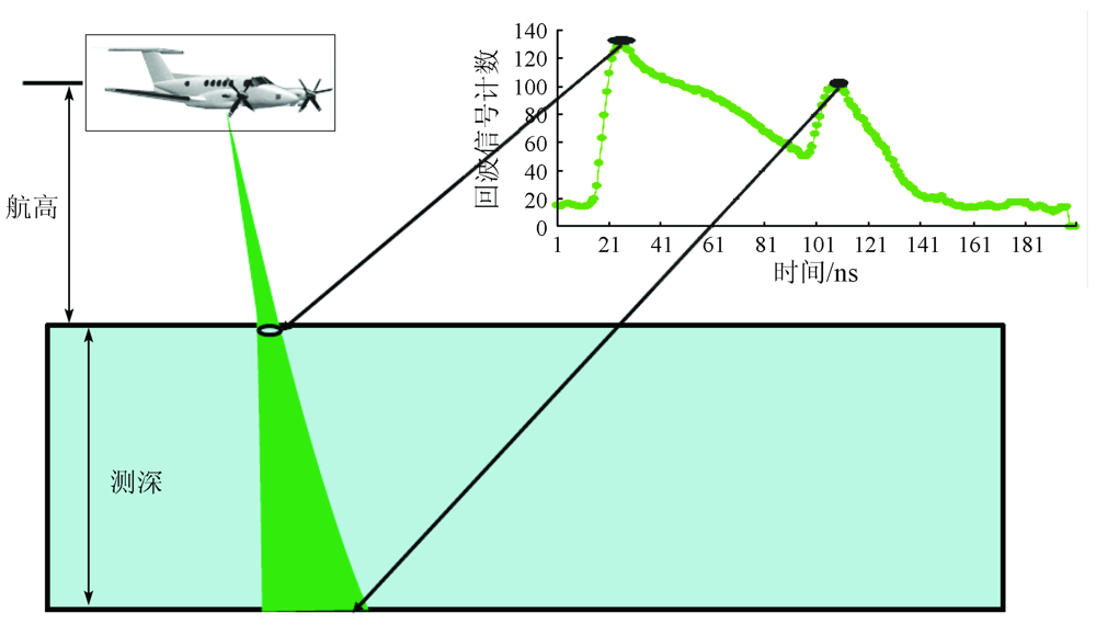
Abstract  

Conventional methods for regional bathymetry mainly use shipborne acoustic detection technologies. However, since the hull cannot access the coastal shallow waters and the areas with dense islands and coral reefs, there is no available data of near-coastal areas. These problems can be effectively solved with the emergence and development of airborne lidar bathymetric technology, which has become a fast and efficient method for water-depth and submarine topographic exploration. Based on the airborne laser sounder CZMIL Nova, this paper introduces the characteristics and influencing factors of the land-sea integrated technologic surveying and its preliminary application in the land-sea integrated topographic surveying of islands.

Keywords airborne laser bathymetry      CZMIL      remote sensing      coastal zone      topography     
ZTFLH:  TP79  
Issue Date: 23 December 2021
Service
E-mail this article
E-mail Alert
RSS
Articles by authors
Fang WU
Dingjian JIN
Zonggui ZHANG
Xinyang JI
Tianqi LI
Yu GAO
Cite this article:   
Fang WU,Dingjian JIN,Zonggui ZHANG, et al. A preliminary study on land-sea integrated topographic surveying based on CZMIL bathymetric technique[J]. Remote Sensing for Natural Resources, 2021, 33(4): 173-180.
URL:  
https://www.gtzyyg.com/EN/10.6046/zrzyyg.2021007     OR     https://www.gtzyyg.com/EN/Y2021/V33/I4/173
类别 技术指标 CZMIL Nova Hawk Eye III VQ-880G LADS MK III
一般指标 工作航高/m 400 ~1 000 400 ~600 600 ~1 600 400 ~1 000
飞行速度/kts 140 ~175 140 ~175 140 ~175 125 ~175
测量指标 激光扫描频率/kHz 水深70/10地形 80 水深35/10地形 500 550 512/1.5
最大测深 1.5 secchi 标称3.0 secchi
最深可达80 m
浅水2.0/ K d 浅水2.2/ K d
深水4.2/ K d 深水4.0/ K d
0 . 3 2 + 0.013 d 2  m, 2σ 0 . 3 2 + 0.013 d 2   m, 2σ
测深精度 0.025 m 0.5 m
水深 0.8 m×0.8 m
陆地 0.3 m×0.3 m
水深 0.8 m×0.8 m
陆地 0.1 m×0.1 m
测点密度 标称69 pts/m2 2 m×2 m
Tab.1  Main technical specifications of typical ALB system
Fig.1  Schematic diagram of bathymetric survey[10]
Fig.2-1  Profile analysis of ALB system based on topographic survey
Fig.2-2  Profile analysis of ALB system based on topographic survey
Fig.3  Land and sea integrated topographic survey(CZMIL Nova)
Fig.4  Bottom reflectivity curves (taken from test report of AGRS)
水质情况 Kd Dmax(白天)/m Dmax(夜间)/m
非常洁净 0.07 50 71
洁净 0.10 35 50
水质情况 Kd Dmax(白天)/m Dmax(夜间)/m
一般洁净1 0.15 23 33
一般洁净2 0.20 18 25
浑浊 0.30 12 17
非常浑浊 0.50 7 10
Tab.2  Statistics of the maximum detection depth(Optech,2013)
Fig.5  Technology flow of ALB survey
Fig.6  Calibration result of laser
统计参数 深度 平均误差 标准差 RMSE 系统标
称精度
数值 30 -0.304 0.211 0.369 0.492
Tab.3  Statistics of laser measurement accuracy in test area(m)
Fig.7  Application of land and sea integrated topographic products
[1] 徐广袖, 翟国君, 吴太旗, 等. 机载激光测深作业的关键技术问题[J]. 海洋测绘, 2019,39(2):45-49.
[1] Xu G X, Zhai G J, Wu T Q, et al. The key technical issues on airborne LiDAR bathymetry operation[J]. Hydrographic Surveying and Charting, 2019,39(2):45-49.
[2] 刘焱雄, 郭锴, 何秀风, 等. 机载激光测深技术及其研究进展[J]. 武汉大学学报(信息科学版), 2017,42(9):1185-1194.
[2] Liu Y X, Guo K, He X F, et al. Research progress of airborne laser bathymetry technology[J]. Geomatics and Information Science of Wuhan University, 2017,42(9):1185-1194.
[3] 翟国君, 王克平, 刘玉红. 机载激光测深技术[J]. 海洋测绘, 2014,34(2):72-75.
[3] Zhai G J, Wang K P, Liu Y H. Technology of airborne laser bathymetry[J]. Hydrographic Surveying and Charting, 2014,34(2):72-75.
[4] 翟国君, 吴太旗, 欧阳永忠, 等. 机载激光测深技术研究进展[J]. 海洋测绘, 2012,32(2):67-71.
[4] Zhai G J, Wu T Q, Ouyang Y Z, et al. The development of airborne laser bathymetry[J]. Hydrographic Surveying and Charting, 2012,32(2):67-71.
[5] 刘智敏, 杨安秀, 阳凡林, 等. 机载LiDAR测深在海洋测绘中应用的可行性分析[J]. 海洋测绘, 2018,38(4):43-47.
[5] Liu Z M, Yang A X, Yang F L, et al. The feasibility analysis for the airborne LiDAR bathymetry application in marine surveying and charting[J]. Hydrographic Surveying and Charting, 2018,38(4):43-47.
[6] CZMIL HydroFusion Manual & CZMIL Operation Manual[Z]. Canada:Teledyne Optech Inc. 2017.
[7] 贺岩, 胡善江, 陈卫标, 等. 国产机载双频激光雷达探测技术研究进展[J]. 激光与光电子学进展, 2018,55(8):082801.
[7] He Y, Hu S J, Chen W B, et al. Research progress of domestic airborne dual-frequency LiDAR detection technology[J]. Laser & Optoelectronics Progress, 2018,55(8):082801.
[8] Tuell G, Barbor K, Wozencraft J. Overview of the coastal zone mapping and imaging LiDAR(CZMIL):A new multi-sensor airborne mapping system for the U.S. army corps of engineers[C]//Proceedings of SPIE-The International Society for Optical Engineering, 2010.
[9] 毕世普, 别君, 张勇. 机载LiDAR在海岸带地形测量中的应用[J]. 海洋地质前沿, 2012,28(11):59-63.
[9] Bi S P, Bie J, Zhang Y. Application of airborne LiDAR to coastial topographic survey[J]. Marine Geology Letters, 2012,28(11):59-63.
[10] 叶修松. 机载激光水深探测技术基础及数据处理方法研究[D]. 郑州:解放军信息工程大学, 2010.
[10] Ye X S. Research on principle and data processing methods of airborne laser bathymetric technique[D]. Zhengzhou:Information Engineering University, 2010.
[11] Fuchs E, Tuell G. Conceptual design of the CZMIL data acquisition system (DAS):Integrating a new bathymetric lidar with a commercial spectrometer and metric camera for coastal mapping applications[C]//Proceedings of SPIE-The International Society for Optical Engineering, 2010.
[12] 金鼎坚, 吴芳, 于坤, 等. 机载激光雷达测深系统大规模应用测试与评估——以中国海岸带为例[J]. 红外与激光工程, 2020,49(s2):9-23.
[12] Jin D J, Wu F, Yu K, et al. Large-scale application test and evaluation of an airborne lidar bathymetry system——A case study in China’s coastal zone[J]. Infrared and Laser Engineering, 2020,49(s2):9-23.
[13] Tuell G, Barbor K, Wozencraft J. Overview of the coastal zone mapping and imaging LiDAR (CZMIL):A new multi-sensor airborne mapping system for the U.S. Army Corps of Engineers[C]//SPIE, 2010,7695:76950R.
[14] 王宗伟, 朱士才, 卢刚, 等. CZMIL机载激光测深系统及其在骆马湖测深试验评估[J]. 海洋学研究, 2017,35(3):20-26.
[14] Wang Z W, Zhu S C, Lu G, et al. CZMIL airborne laser sounding system and its testing evaluation in Luoma Lake[J]. Journal of Marine Sciences, 2017,35(3):20-26.
[15] CZMIL Calibration Survey Requirements[Z]. Canada:Teledyne Optech Inc. 2017.
[16] 亓发庆, 黎广钊, 孙永福, 等. 北部湾涠洲岛地貌的基本特征[J]. 海洋科学进展, 2003,21(1):41-50.
[16] Qi F Q, Ni G Z, Sun Y F, et al. Basic geomorphologic features of the Weizhou Island of the Beibu Bay[J]. Advances in Marine Science, 2003,21(1):41-50.
[1] NIU Xianghua, HUANG Wei, HUANG Rui, JIANG Sili. A high-fidelity method for thin cloud removal from remote sensing images based on attentional feature fusion[J]. Remote Sensing for Natural Resources, 2023, 35(3): 116-123.
[2] DONG Ting, FU Weiqi, SHAO Pan, GAO Lipeng, WU Changdong. Detection of changes in SAR images based on an improved fully-connected conditional random field[J]. Remote Sensing for Natural Resources, 2023, 35(3): 134-144.
[3] WANG Jianqiang, ZOU Zhaohui, LIU Rongbo, LIU Zhisong. A method for extracting information on coastal aquacultural ponds from remote sensing images based on a U2-Net deep learning model[J]. Remote Sensing for Natural Resources, 2023, 35(3): 17-24.
[4] TANG Hui, ZOU Juan, YIN Xianghong, YU Shuchen, HE Qiuhua, ZHAO Dong, ZOU Cong, LUO Jianqiang. River and lake sand mining in the Dongting Lake area: Supervision based on high-resolution remote sensing images and typical case analysis[J]. Remote Sensing for Natural Resources, 2023, 35(3): 302-309.
[5] YU Hang, AN Na, WANG Jie, XING Yu, XU Wenjia, BU Fan, WANG Xiaohong, YANG Jinzhong. High-resolution remote sensing-based dynamic monitoring of coal mine collapse areas in southwestern Guizhou: A case study of coal mine collapse areas in Liupanshui City[J]. Remote Sensing for Natural Resources, 2023, 35(3): 310-318.
[6] WANG Jing, WANG Jia, XU Jiangqi, HUANG Shaodong, LIU Dongyun. Exploring ecological environment quality of typical coastal cities based on an improved remote sensing ecological index: A case study of Zhanjiang City[J]. Remote Sensing for Natural Resources, 2023, 35(3): 43-52.
[7] YAN Bokun, GAN Fuping, YIN Ping, GE Xiaoli, GUO Yi, BAI Juan. Remote sensing observations of tidal flats, shorelines, and aquacultural water bodies along coastal zones in China mainland during 1989—2021[J]. Remote Sensing for Natural Resources, 2023, 35(3): 53-63.
[8] XU Xinyu, LI Xiaojun, ZHAO Heting, GAI Junfei. Pansharpening algorithm of remote sensing images based on NSCT and PCNN[J]. Remote Sensing for Natural Resources, 2023, 35(3): 64-70.
[9] LIU Li, DONG Xianmin, LIU Juan. A performance evaluation method for semantic segmentation models of remote sensing images considering surface features[J]. Remote Sensing for Natural Resources, 2023, 35(3): 80-87.
[10] FANG He, ZHANG Yuhui, HE Yue, LI Zhengquan, FAN Gaofeng, XU Dong, ZHANG Chunyang, HE Zhonghua. Spatio-temporal variations of vegetation ecological quality in Zhejiang Province and their driving factors[J]. Remote Sensing for Natural Resources, 2023, 35(2): 245-254.
[11] ZHANG Xian, LI Wei, CHEN Li, YANG Zhaoying, DOU Baocheng, LI Yu, CHEN Haomin. Research progress and prospect of remote sensing-based feature extraction of opencast mining areas[J]. Remote Sensing for Natural Resources, 2023, 35(2): 25-33.
[12] MA Shibin, PI Yingnan, WANG Jia, ZHANG Kun, LI Shenghui, PENG Xi. High-efficiency supervision method for green geological exploration based on remote sensing[J]. Remote Sensing for Natural Resources, 2023, 35(2): 255-263.
[13] WANG Ping. Application of thermal infrared remote sensing in monitoring the steel overcapacity cutting[J]. Remote Sensing for Natural Resources, 2023, 35(2): 271-276.
[14] LI Tianchi, WANG Daoru, ZHAO Liang, FAN Renfu. Classification and change analysis of the substrate of the Yongle Atoll in the Xisha Islands based on Landsat8 remote sensing data[J]. Remote Sensing for Natural Resources, 2023, 35(2): 70-79.
[15] DIAO Mingguang, LIU Yong, GUO Ningbo, LI Wenji, JIANG Jikang, WANG Yunxiao. Mask R-CNN-based intelligent identification of sparse woods from remote sensing images[J]. Remote Sensing for Natural Resources, 2023, 35(2): 97-104.
Viewed
Full text


Abstract

Cited

  Shared   
  Discussed   
京ICP备05055290号-2
Copyright © 2017 Remote Sensing for Natural Resources
Support by Beijing Magtech