|
|
 |
|
|
|
|
Comparison and analysis of water indexes in muddy coasts based on MODIS data: A case study of the Yellow River Delta coast |
Jiaping WU1, Yang ZHANG1( ), Jie ZHANG2, Shenglong FAN1, Chao YANG1, Xiaofang ZHANG1 ), Jie ZHANG2, Shenglong FAN1, Chao YANG1, Xiaofang ZHANG1 |
1. College of Resources and Environment, Fujian Agriculture and Forestry University, Fuzhou 350002, China
2. Poyang Lake Research Center, Jiangxi Academy of Sciences, Nanchang 330096, China |
|
|
|
|
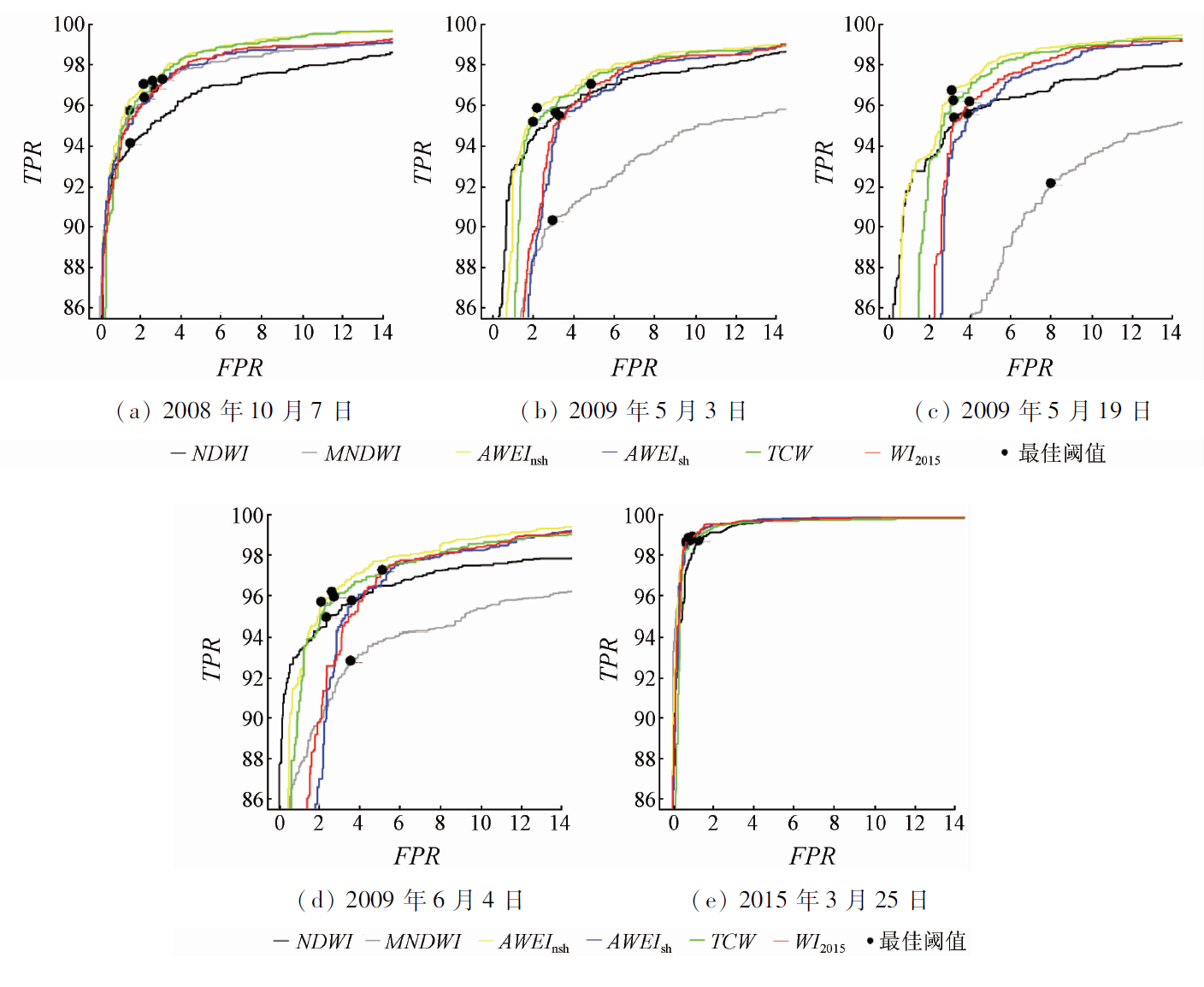
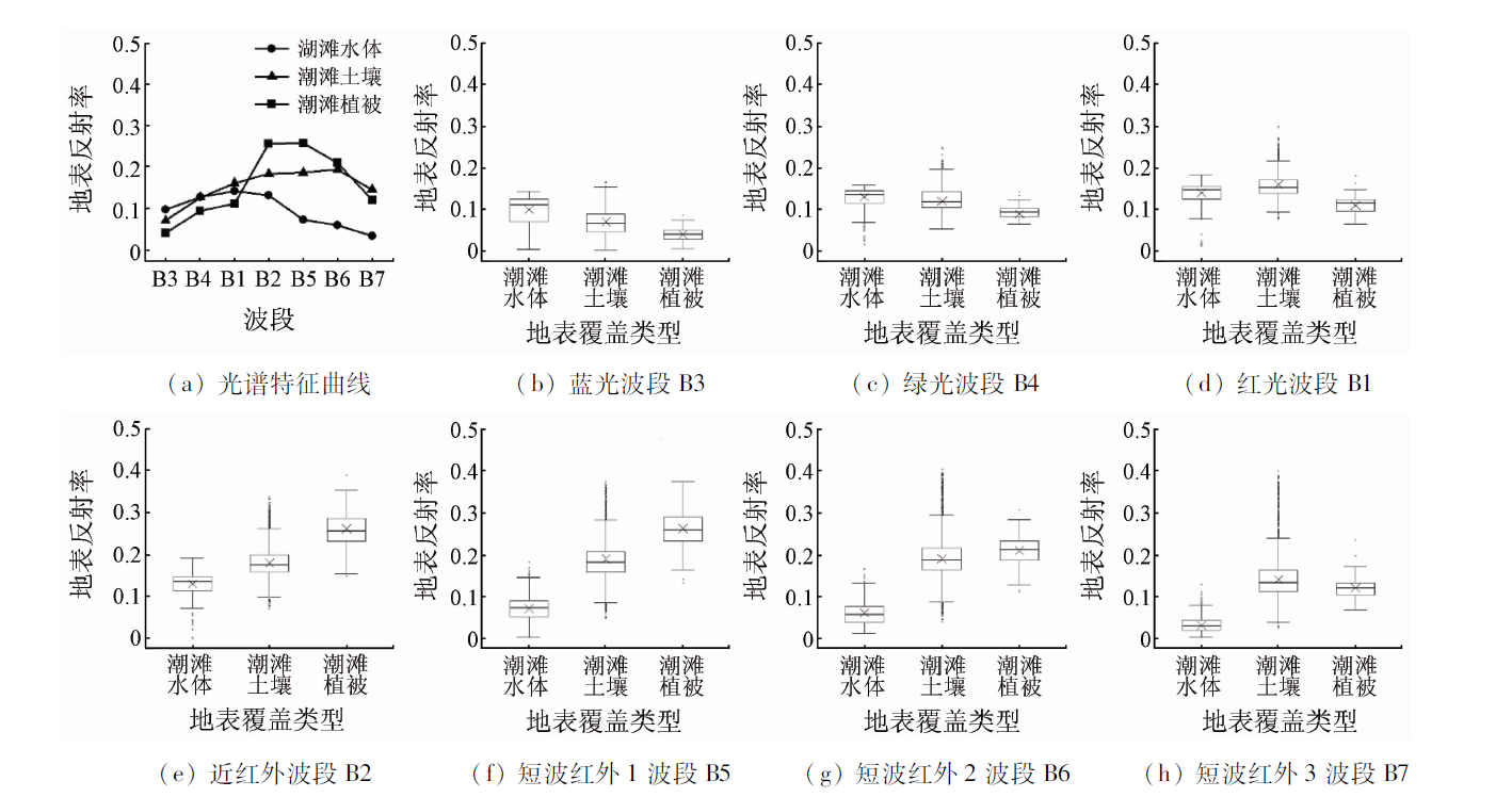
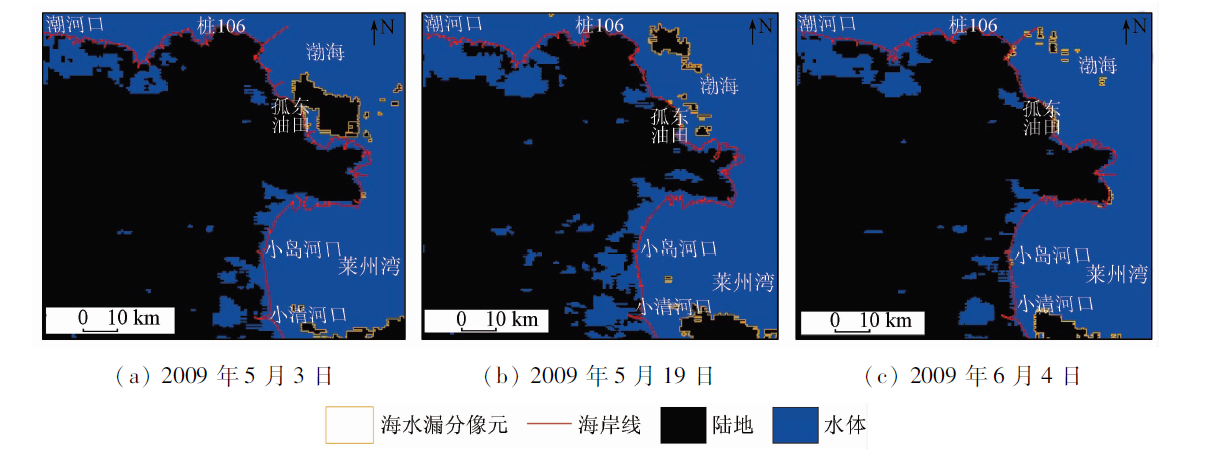
Abstract Muddy coastal areas have a unique and complex water environment. It is of great scientific significance to deeply analyze the water extraction efficiency of water index in this area. The authors took the Yellow River Delta coast as the study area and used the MODIS and Landsat remote sensing data of 2008, 2009 and 2015. The water extraction performance of 6 water index (NDWI, MNDWI, AWEInsh, AWEIsh, TCW, WI2015) were analyzed from spectral characteristics of land cover types. The best threshold of each water index was obtained through the ROC curve. The accuracy and extraction errors of water indexes in muddy coastal area were studied, and the influence of different land cover factors on water extraction was analyzed. The results show that the AWEInsh have the best performance in extraction of water, with an overall accuracy of 97.29%, mapping accuracy of 96.84%, and user accuracy of 97.69%. The accuracy of seawater extraction by different water indexes is higher than 90%. The extraction accuracy of land water is at general level and the map precision is less than 80%. The capability of NDWI for identifying tidal flat water is poor, and the accuracy of mapping is lower than that of other water indexes. The different water indexes have high omission error of land water, and the omission errors of seawater and tidal flat water are low. The MNDWI has the highest omission error of seawater. The influence of the tidal flat soil on the water extraction is the greatest, followed by the cultivated soil. The sparse vegetation, luxuriant vegetation, and built-up area have the least impact. This study provides a reference for the further development of water extraction methods suitable for muddy coastal areas.
|
| Keywords
MODIS
water index
ROC
accuracy evaluation
Yellow River Delta coast
|
|
|
|
Corresponding Authors:
Yang ZHANG
E-mail: zhangyang2907@163.com
|
|
Issue Date: 30 August 2019
|
|
|
| [1] |
水利部海河水利委员会漳河上游管理局, 河北工程大学. 遥感技术在水环境评价中的应用[M]. 北京: 中国水利水电出版社, 2015.
|
| [1] |
Haihe Water Conservancy Commission of the Ministry of Water Resources Zhanghe Upper Reaches Administration Bureau, Hebei University of Engineering. Application of Remote Sensing Technology in Water Environment Evaluation[M]. Beijing: China Water and Power Press, 2015.
|
| [2] |
Ji L, Zhang L, Wylie B . Analysis of dynamic thresholds for the normalized difference water index[J]. Photogrammetric Engineering and Remote Sensing, 2009,75(11):1307-1317.
|
| [3] |
Crist E P . A TM Tasseled Cap equivalent transformation for reflectance factor data[J]. Remote Sensing of Environment, 1985,17(3):301-306.
|
| [4] |
McFeeters S K . The use of the normalized difference water index (NDWI) in the delineation of open water features[J]. International Journal of Remote Sensing, 1996,17(7):1425-1432.
|
| [5] |
徐涵秋 . 利用改进的归一化差异水体指数(MNDWI)提取水体信息的研究[J]. 遥感学报, 2005,9(5):589-595.
doi: 10.3321/j.issn:1007-4619.2005.05.012
url: http://d.wanfangdata.com.cn/Periodical/ygxb200505012
|
| [5] |
Xu H Q . A study on information extraction of water body with the modified normalized difference water index(MNDWI)[J]. Journal of Remote Sensing, 2005,9(5):589-595.
|
| [6] |
Feyisa G L, Meilby H, Fensholt R , et al. Automated water extraction index:A new technique for surface water mapping using Landsat imagery[J]. Remote Sensing of Environment, 2014,140(1):23-35.
|
| [7] |
Fisher A, Flood N, Danaher T . Comparing Landsat water index methods for automated water classification in eastern Australia[J]. Remote Sensing of Environment, 2016,175:167-182.
|
| [8] |
Sharma R, Tateishi R, Hara K , et al. Developing superfine water index (SWI) for global water cover mapping using MODIS data[J]. Remote Sensing, 2015,7(10):13807-13841.
|
| [9] |
莫伟华, 孙涵, 钟仕全 , 等. MODIS水体指数模型(CIWI)研究及其应用[J].遥感信息, 2007(5):16-21.
|
| [9] |
Mo W H, Sun H, Zhong S Q , et al. Research on the CIWI model and its application[J].Remote Sensing Information, 2007(5):16-21.
|
| [10] |
Hui F, Xu B, Huang H , et al. Modeling spatial-temporal change of Poyang Lake using multi-temporal Landsat imagery[J]. International Journal of Remote Sensing, 2008,29(20):5767-5784.
|
| [11] |
Li W B, Du Z Q, Ling F , et al. A comparison of land surface water mapping using the normalized difference water index from TM,ETM+ and ALI[J]. Remote Sensing, 2013,5(11):5530-5549.
|
| [12] |
廖程浩, 刘雪华 . MODIS数据水体识别指数的识别效果比较分析[J]. 国土资源遥感, 2008,20(4):22-26.doi: 10.6046/gtzyyg.2008.04.06.
doi: 10.6046/gtzyyg.2008.04.06
|
| [12] |
Liao C H, Liu X H . An effectiveness comparison between water body indices based on MODIS data[J]. Remote Sensing for Land and Resources, 2008,20(4):22-26.doi: 10.6046/gtzyyg.2008.04.06.
|
| [13] |
车向红, 冯敏, 姜浩 , 等. 2000—2013年青藏高原湖泊面积MODIS遥感监测分析[J]. 地球信息科学学报, 2015,17(1):99-107.
doi: 10.3724/SP.J.1047.2015.00099
|
| [13] |
Che X H, Feng M, Jiang H , et al. Detection and analysis of Qinghai-Tibet Plateau lake area from 2000 to 2013[J]. Journal of Geo-Information Science, 2015,17(1):99-107.
|
| [14] |
王净, 李亚春, 景元书 . 基于MODIS数据的水体识别指数方法的比较研究[J]. 气象科学, 2009,29(3):342-347.
|
| [14] |
Wang J, Li Y C, Jing Y S . Comparison and research on the different index models used in water extraction based on remote sensing data of MODIS[J]. Journal of the Meteorological Sciences, 2009,29(3):342-347.
|
| [15] |
成国栋 . 黄河三角洲现代沉积作用及模式[M]. 北京: 地质出版社, 1991: 96-100.
|
| [15] |
Cheng G D. The Modern Sedimentation and Model of the Yellow River Delta[M]. Beijing: Geological Publishing House, 1991: 96-100.
|
| [16] |
时连强, 李九发, 应铭 , 等. 近、现代黄河三角洲发育演变研究进展[J]. 海洋科学进展, 2005,23(1):96-104.
|
| [16] |
Shi L Q, Li J F, Ying M , et al. Advances in researches on the Modern Yellow River Delta development and evolution[J]. Advances in Marine Science, 2005,23(1):96-104.
|
| [17] |
Zhang Y . Coastal environmental monitoring using remotely sensed data and GIS techniques in the modern Yellow River Delta,China[J]. Environmental Monitoring and Assessment, 2011,179(1-4):15-29.
|
| [18] |
张旸, 陈沈良, 谷国传 . 黄河三角洲沿岸日潮区的空间分布与潮汐特征[J]. 水动力学研究与进展, 2015,30(5):540-548.
|
| [18] |
Zhang Y, Chen S L, Gu G C . Spatial extent and tidal characteristics of the diurnal tidal zone along the Yellow River Delta coast[J]. Journal of Hydrodynamics, 2015,30(5):540-548.
|
| [19] |
张高生, 王仁卿 . 现代黄河三角洲生态环境的动态监测[J]. 中国环境科学, 2008,28(4):380-384.
doi:
|
| [19] |
Zhang G S, Wang R Q . Research on dynamic monitoring of ecological environment in modern Yellow River Delta[J]. China Environmental Science, 2008,28(4):380-384.
|
| [20] |
汪小钦, 王钦敏, 刘高焕 , 等. 黄河三角洲土地利用/覆盖格局与演化分析[J]. 水土保持学报, 2006,20(5):158-161.
|
| [20] |
Wang X Q, Wang Q M, Liu G H , et al. Analysis of land use and land cover change in Yellow River Delta[J]. Journal of Soil and Water Conservation, 2006,20(5):158-161.
|
| [21] |
刘玉洁, 杨忠东 . MODIS遥感信息处理原理与算法[M]. 北京: 科学出版社, 2001: 1-4.
|
| [21] |
Liu Y J, Yang Z D. The Principle and Algorithm of MODIS Remote Sensing Information Processing[M]. Beijing: Science Press, 2001: 1-4.
|
| [22] |
Vermote E F, Kotchenova S Y, Ray J P . MODIS Surface Reflectance User’s Guide[M]. Land Surface Reflectance Science Computing Facility, 2011.
|
| [23] |
Sun Z, Zhao Y, Li S . Research on polarized remote sensing of monitoring of water pollution [C]//International Conference on Bioinformatics and Biomedical Engineering.IEEE, 2010: 1-5.
|
| [24] |
Fawcett T . An introduction to ROC analysis[J]. Pattern Recognition Letters, 2006,27(8):861-874.
|
| [25] |
Robin X, Turck N, Hainard A , et al. pROC:An open-source package for R and S+ to analyze and compare ROC curves[J]. BMC Bioinformatics, 2011,12(1):1-8.
|
| [26] |
韩震 . 海岸带淤泥质潮滩和Ⅱ类水体悬浮泥沙遥感信息提取与定量反演研究[D]. 上海:华东师范大学, 2004.
|
| [26] |
Han Z . Remote Sensing Information Extraction and Quantitative Inversion Research of Silt Tidal Fiat and Suspended Sediment of CaseⅡWaters in Coast Zone[D]. Shanghai:East China Normal University, 2004.
|
| [27] |
顾燕, 张鹰, 李欢 . 基于实测光谱的潮滩土壤含水量遥感反演模型研究[J]. 湿地科学, 2013,11(2):167-172.
|
| [27] |
Gu Y, Zhang Y, Li H . Remote sensing retrieval model on soil moisture content of tidal flat based on measured spectra[J]. Wetland Science, 2013,11(2):167-172.
|
| [28] |
任广波, 张杰, 马毅 . 黄河三角洲典型植被地物光谱特征分析与可分性查找表[J]. 海洋环境科学, 2015,34(3):420-426.
|
| [28] |
Ren G B, Zhang J, Ma Y . Spectral discrimination and separable feature lookup table of typical vegetation species in Yellow River Delta wetland[J]. Marine Environmental Science, 2015,34(3):420-426.
|
| [29] |
毕乃双, 杨作升, 王厚杰 , 等. 黄河调水调沙期间黄河入海水沙的扩散与通量[J]. 海洋地质与第四纪地质, 2010,30(2):27-34.
|
| [29] |
Bi N S, Yang Z S, Wang H J , et al. Characteristics of dispersal of the Yellow River water and sediment to the sea during water-sediment regulation period of the Yellow River and its dynamic mechanism[J]. Marine Geology and Quaternary Geology, 2010,30(2):27-34.
|
| [30] |
Ryu J H, Won J S, Min K D . Waterline extraction from Landsat TM data in a tidal flat:A case study in Gomso Bay,Korea[J]. Remote Sensing of Environment, 2002,83(3):442-456.
|
|
Viewed |
|
|
|
Full text
|
|
|
|
|
Abstract
|
|
|
|
|
Cited |
|
|
|
|
| |
Shared |
|
|
|
|
| |
Discussed |
|
|
|
|
 2019,
Vol. 31
2019,
Vol. 31