|
|
|
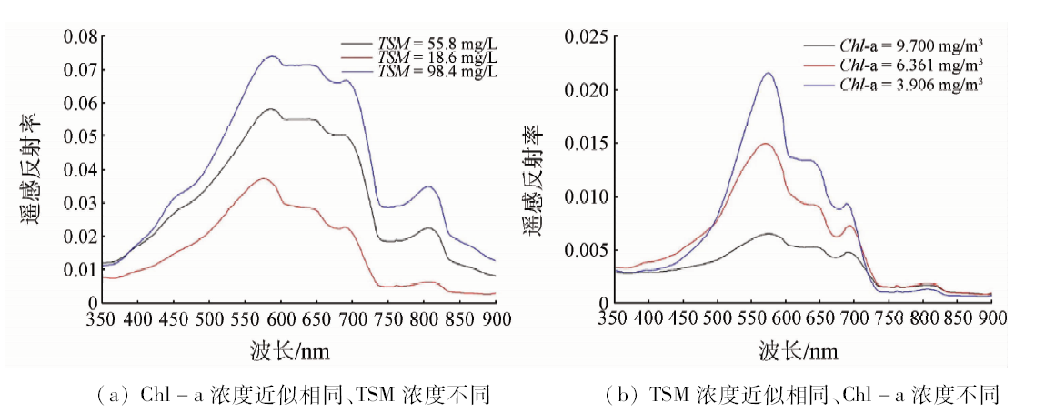
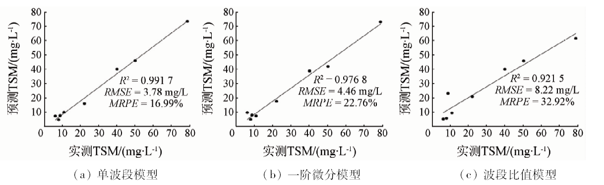
Abstract Total suspended matter is one of the important parameters to evaluate water quality. In this study, 33 data samples containing reflectance of water surface, concentration of total suspended matter and chlorophyll-a were used to conduct retrieval of total suspended matter, establish retrieval model and verify accuracy of model based on comparative analysis between field measured spectral reflectance and total suspended matter in Poyang Lake during the flood season. These models were single band, first-order differential and band ratio, respectively. The results showed that the R 2 of three models was greater than 0.9, and the best was the single band model, and R 2, RMSE and MRPE were 0.9805, 3.78mg/L and 16.99%, respectively. The single band model gave the better performance when it was applied to GF-1 satellite image data on August 3, 2015 and was validated, with R 2, RMSE and MRPE being 0.8477, 12.23mg/L and 35.22%, respectively. It was also shown that the overall level of suspended matter concentration was low and the average value was 23.26mg/L. The higher value of total suspended matter was concentrated in the northern channel area. The concentration values of suspended matter was distributed uniformly in other areas of Poyang Lake. This model was further applied to GF-1 satellite image data on October 24, 2015 and was validated using 21 data samples of total suspended matter concentration obtained on October 23 and October 24, 2015. The retrieval accuracy was close to the result of image on August 3, 2015. The results indicate that this model can be also applied to retrieving the total suspended matter concentration of other periods in Poyang Lake. By analysis of field measured spectral reflectance and application of remote sensing image data, this study can provide reference for the retrieval of total suspended matter and environment monitoring of Poyang Lake.
|
| Keywords
total suspended matter concentration
retrieval method
GF-1 satellite data
field measured water spectra
Poyang Lake
|
|
|
|
Corresponding Authors:
Jian XU
E-mail: jianxu@jxnu.edu.cn
|
|
Issue Date: 15 March 2019
|
|
|
| [1] |
马逸麟, 马逸琪 . 鄱阳湖湿地的保护与利用[J].国土与自然资源研究, 2003(4):66-67.
doi: 10.3969/j.issn.1003-7853.2003.04.031
url: http://d.wanfangdata.com.cn/Periodical/gtyzrzyyj200304031
|
| [1] |
Ma Y L, Ma Y Q . Protection and utilization of Poyang Lake Wetland[J].Territory and Natural Resources Study, 2003(4):66-67.
|
| [2] |
de Leeuw J, Shankman D, Wu G , et al. Strategic assessment of the magnitude and impacts of sand mining in Poyang Lake,China[J]. Regional Environmental Change, 2010,10(2):95-102.
doi: 10.1007/s10113-009-0096-6
url: http://link.springer.com/10.1007/s10113-009-0096-6
|
| [3] |
李海军, 陈晓玲, 陆建忠 , 等. 考虑采砂影响的鄱阳湖丰水期悬浮泥沙浓度模拟[J]. 湖泊科学, 2016,28(2):421-431.
doi: 10.18307/2016.0223
url: http://www.cnki.com.cn/Article/CJFDTotal-FLKX201602023.htm
|
| [3] |
Li H J, Chen X L, Lu J Z , et al. Numerical simulation of suspended sediment concentration in Lake Poyang during flood season considering dredging activities[J]. Journal of Lake Science, 2016,28(2):421-431.
|
| [4] |
汪小钦, 王钦敏, 邬群勇 , 等. 遥感在悬浮物质浓度提取中的应用——以福建闽江口为例[J]. 遥感学报, 2003,7(1):54-57.
doi: 10.3321/j.issn:1007-4619.2003.01.010
url: http://d.wanfangdata.com.cn/Periodical/ygxb200301010
|
| [4] |
Wang X Q, Wang Q M, Wu Q Y , et al. Estimating suspended sediment concentration in coastal waters of Minjiang River using remote sensing images[J]. Journal of Remote Sensing, 2003,7(1):54-57.
|
| [5] |
王心源, 李文达, 严小华 . 基于Landsat TM/ETM+数据提取巢湖悬浮泥沙相对浓度的信息与空间分布变化[J]. 湖泊科学, 2007,19(3):255-260.
doi: 10.18307/2007.0305
url: http://d.wanfangdata.com.cn/Periodical/hpkx200703005
|
| [5] |
Wang X Y, Li W D, Yan X H , et al. Information extraction for suspended sediment in Lake Chaohu and its distribution based on Landsat TM/ETM+ data[J]. Journal of Lake Science, 2007,19(3):255-260.
|
| [6] |
刘小丽, 沈芳, 朱伟健 , 等. MERIS卫星数据定量反演长江河口的悬沙浓度[J]. 长江流域资源与环境, 2009,18(11):1026-1031.
doi: 10.3969/j.issn.1004-8227.2009.11.006
url: http://www.cqvip.com/Main/Detail.aspx?id=32091463
|
| [6] |
Liu X L, Shen F, Zhu W J , et al. Quantitative retrieval for suspended sediment concentration by using MERIS satellite data in the Yangtze River Estuary[J]. Resources and Environment in the Yangtze Basin, 2009,18(11):1026-1031.
|
| [7] |
Yu Q, Tian Y Q, Chen R F , et al. Functional linear analysis of in situ hyperspectral data for assessing CDOM in rivers[J]. Photogrammetric Engineering and Remote Sensing, 2010,76(10):1147-1158.
doi: 10.14358/PERS.76.10.1147
url: http://openurl.ingenta.com/content/xref?genre=article&issn=0099-1112&volume=76&issue=10&spage=1147
|
| [8] |
宋庆君, 马荣华, 唐军武 , 等. 秋季太湖悬浮物高光谱估算模型[J]. 湖泊科学, 2008,20(2):196-202.
doi: 10.3321/j.issn:1003-5427.2008.02.010
url: http://www.cnki.com.cn/Article/CJFDTotal-FLKX200802012.htm
|
| [8] |
Song Q J, Ma R H, Tang J W , et al. Models of estimated total suspend matter concentration base on hyper-spectrum in Lake Taihu,in autumn[J]. Journal of Lake Science, 2008,20(2):196-202.
|
| [9] |
陈建辉, 徐涵秋 . 晋江水体悬浮物浓度的高光谱建模分析[J]. 遥感技术与应用, 2008,23(6):653-657.
url: http://d.wanfangdata.com.cn/Periodical/ygjsyyy200806009
|
| [9] |
Chen J H, Xu H Q . Modeling of the suspended solid concentration of the Jin River based on high-spectral resolution data[J]. Remote Sensing Technology and Application, 2008,23(6):653-657.
|
| [10] |
孙德勇, 李云梅, 王桥 , 等. 基于实测高光谱的太湖水体悬浮物浓度遥感估算研究[J]. 红外与毫米波学报, 2009,28(2):124-128.
url: http://www.opticsjournal.net/Articles/Abstract?aid=OJ1012130001209EaHdK
|
| [10] |
Sun D Y, Li Y M, Wang Q , et al. Study on remote sensing estimation of suspended matter concentrations based on in situ hyperspectral data in Lake Tai waters[J]. Journal of Infared and Millimeter Waves, 2009,28(2):124-128.
|
| [11] |
白照广 . 高分一号卫星的技术特点[J].中国航天, 2013(8):5-9.
url: http://www.cqvip.com/QK/94543A/201308/47106806.html
|
| [11] |
Bai Z G . The technical features of GF-1 satellite[J].Erospace China, 2013(8):5-9.
|
| [12] |
刘茜 , David G. Rossiter.基于高光谱数据和MODIS影像的鄱阳湖悬浮泥沙浓度估算[J]. 遥感技术与应用, 2008,23(1):7-11.
url: http://d.wanfangdata.com.cn/Periodical/ygjsyyy200801002
|
| [12] |
Liu Q, David G . R.Estimation on suspended sedimentation concentration of Poyang Lake using MODIS and hyperspectral data[J]. Remote Sensing Technology and Application, 2008,23(1):7-11.
|
| [13] |
王艳姣, 张培群, 董文杰 , 等. 悬浮泥沙反射光谱特性和泥沙量估算试验研究[J].泥沙研究, 2007(5):36-41.
doi: 10.3321/j.issn:0468-155x.2007.05.006
|
| [13] |
Wang Y J, Zhang P Q, Dong W J , et al. Experimental study on reflected spectrum and estimating amount of suspended sediment[J].Journal of Sediment Research, 2007(5):36-41.
|
| [14] |
程乾, 刘波, 李婷 , 等. 基于高分1号杭州湾河口悬浮泥沙浓度遥感反演模型构建及应用[J]. 海洋环境科学, 2015,34(4):558-563.
url: http://www.cqvip.com/QK/95945X/201504/665591183.html
|
| [14] |
Cheng Q, Liu B, Li T , et al. Research on remote sensing retrieval of suspended sediment concentration in Hangzhou Bay by GF-1 satellite[J]. Marine Environmental Science, 2015,34(4):558-563.
|
| [15] |
Li J, Chen X, Tian L , et al. Improved capabilities of the Chinese high-resolution remote sensing satellite GF-1 for monitoring suspended particulate matter (SPM) in inland waters:Radiometric and spatial considerations[J]. ISPRS Journal of Photogrammetry and Remote Sensing, 2015,106:145-156.
doi: 10.1016/j.isprsjprs.2015.05.009
url: https://linkinghub.elsevier.com/retrieve/pii/S092427161500146X
|
| [16] |
侍昊, 沈文娟, 李杨 , 等. 高分系列卫星影像特征及其在太湖生态环境监测中的应用[J]. 南京林业大学学报(自然科学版), 2016,40(6):63-68.
doi: 10.3969/j.issn.1000-2006.2016.06.010
url: http://www.cnki.com.cn/Article/CJFDTotal-NJLY201606010.htm
|
| [16] |
Shi H, Shen W J, Li Y , et al. Characteristics of GF images and application in eco-environmental monitoring in Taihu Lake[J]. Journal of Nanjing Forestry University (Natural Sciences Edition), 2016,40(6):63-68.
|
| [17] |
李四海, 恽才兴 . 河口表层悬浮泥沙气象卫星遥感定量模式研究[J]. 遥感学报, 2001,5(2):154-160.
doi: 10.3321/j.issn:1007-4619.2001.02.015
url: http://www.cnki.com.cn/Article/CJFDTotal-YGXB200102014.htm
|
| [17] |
Li S H, Hui C X . A study on the quantitative model of the suspended sediment concentration from the meteorological satellite imagery[J]. Journal of Remote Sensing, 2001,5(2):154-160.
|
| [18] |
潘德炉, 马荣华 . 湖泊水质遥感的几个关键问题[J]. 湖泊科学, 2008,20(2):139-144.
doi: 10.18307/2008.0201
url: http://d.wanfangdata.com.cn/Periodical/hpkx200802001
|
| [18] |
Pan D L, Ma R H . Several key problems of lake water quality remote sensing[J]. Journal of Lake Science, 2008,20(2):139-144.
|
| [19] |
唐军武, 田国良, 汪小勇 , 等. 水体光谱测量与分析I:水面以上测量法[J]. 遥感学报, 2004,8(1):37-44.
doi: 10.3321/j.issn:1007-4619.2004.01.006
url: http://d.wanfangdata.com.cn/Periodical/ygxb200401006
|
| [19] |
Tang J W, Tian G L, Wang X Y , et al. The methods of water spectra measurement and analysis I:Above-water method[J]. Journal of Remote Sensing, 2004,8(1):37-44.
|
| [20] |
唐兆民, 何志刚, 韩玉梅 . 悬浮泥沙浓度的测量[J]. 中山大学学报(自然科学版), 2003,42(s2):244-247.
doi: 10.3321/j.issn:0529-6579.2003.z2.053
url: http://www.cqvip.com/Main/Detail.aspx?id=8793814
|
| [20] |
Tang Z M, He Z G, Han Y M , et al. The measurement on suspended sediment concentration[J]. Acta Scientiarum Natyralium Universitatis Sunyatseni, 2003,42(2):244-247.
|
| [21] |
陈宇炜, 陈开宁, 胡耀辉 . 浮游植物叶绿素a测定的“热乙醇法”及其测定误差的探讨[J]. 湖泊科学, 2006,18(5):550-552.
doi: 10.18307/2006.0519
url: http://www.cnki.com.cn/Article/CJFDTotal-FLKX200605020.htm
|
| [21] |
Chen Y W, Chen K N, Hu Y H . Discussion on possible error for phytoplankton chlorophyll-a concentration analysis using hot-ethanol extraction method[J]. Journal of Lake Science, 2006,18(5):550-552.
|
| [22] |
郝建亭, 杨武年, 李玉霞 , 等. 基于FLAASH的多光谱影像大气校正应用研究[J].遥感应用, 2008(1):78-81.
doi: 10.3969/j.issn.1000-3177.2008.01.015
url: http://www.cqvip.com/Main/Detail.aspx?id=26655857
|
| [22] |
Hao J T, Yang W N, Li Y X , et al. Atmospheric correction of multi-spectral imagery ASTER[J].Application of Remote Sensing, 2008(1):78-81.
|
| [23] |
曾群, 赵越, 田礼乔 , 等. HJ-1A/1B卫星CCD影像水环境遥感大气校正方法评价研究——以鄱阳湖为例[J]. 光谱学与光谱分析, 2013,33(5):1320-1326.
url: http://www.opticsjournal.net/Articles/Abstract?aid=OJ130521000081PlRoUr
|
| [23] |
Zeng Q, Zhao Y, Tian L Q , et al. Evaluation the atemospheric correction methods for water color remote sensing by using HJ-1A/1B CCD image-taking Poyang Lake in China as a case[J]. Spectroscopy and Spectral Analysis, 2013,33(5):1320-1326.
|
| [24] |
曾群, 张海东, 陈晓玲 , 等. MERIS影像水环境遥感大气校正算法评价——以鄱阳湖叶绿素a浓度反演为例[J]. 湖泊科学, 2016,28(6):1306-1315.
doi: 10.18307/2016.0616
url: http://www.cnki.com.cn/Article/CJFDTotal-FLKX201606016.htm
|
| [24] |
Zeng Q, Zhang H D, Chen X L , et al. Evaluation on the atmospheric correction methods for water color remote SENSING by using MERIS image:A case study on chlorophyll-a concentration of Lake Poyang[J]. Journal of Lake Science, 2016,28(6):1306-1315.
|
| [25] |
Rundquist D C, Han L, Schalles J F , et al. Remote measurement of algal chlorophyll in surface waters:The case for the first derivative of reflectance near 690 nm[J]. Photogrammetric Engineering and Remote Sensing, 1996,62(2):195-200.
doi: 10.1016/S0924-2716(96)90007-6
url: http://europepmc.org/abstract/AGR/IND20524090
|
| [26] |
Song K, Li L, Wang Z , et al. Retrieval of total suspended matter (TSM) and chlorophyll-a (Chl-a) concentration from remote-sensing data for drinking water resources[J]. Environmental Monitoring and Assessment, 2012,184(3):1449-1470.
doi: 10.1007/s10661-011-2053-3
pmid: 21526431
url: http://link.springer.com/10.1007/s10661-011-2053-3
|
| [27] |
陈晓玲, 吴忠宜, 田礼乔 , 等. 水体悬浮泥沙动态监测的遥感反演模型对比分析——以鄱阳湖为例[J]. 遥感监测研究专题, 2007,25(6):19-22.
doi: 10.3321/j.issn:1000-7857.2007.06.004
url: http://www.cnki.com.cn/Article/CJFDTotal-KJDB200706004.htm
|
| [27] |
Chen X L, Wu Z Y, Tian L Q , et al. Inversion model for dynamic monitoring of suspended sediment:A case study on Poyang Lake[J]. Research on Remote Sensing Monitoring, 2007,25(6):19-22.
|
| [28] |
陈军, 周冠华, 温珍河 , 等. 太湖表层悬浮泥沙遥感定量模式研究[J]. 光谱学与光谱分析, 2010,30(1):137-141.
url: http://www.opticsjournal.net/Articles/Abstract?aid=OJ100713000287bIeKhN
|
| [28] |
Chen J, Zhou G H, Wen Z H , et al. Study on quantitative model for suspended sediment concentration in Taihu Lake[J]. Spectroscopy and Spectral Analysis, 2010,30(1):137-141.
|
| [29] |
Gao B C . NDWI:A normalized difference water index for remote sensing of vegetation liquid water from space[J].Remote Sensing of Environment, 1996(58):257-266.
|
| [30] |
毕海芸, 王思远, 曾江源 , 等. 基于TM影像的几种常用水体提取方法的比较和分析[J]. 遥感信息, 2012,27(5):77-82.
doi: 10.3969/j.issn.1000-3177.2012.05.014
url: http://d.wanfangdata.com.cn/Periodical/ygxx201205014
|
| [30] |
Bi H Y, Wang S Y, Zeng J Y , et al. Comparison and analysis of several common water extraction methods based on TM image[J]. Remote Sensing Information, 2012,27(5):77-82.
|
| [31] |
崔丽娟, 翟彦放, 邬国锋 . 鄱阳湖采砂南移扩大影响范围——多源遥感的证据[J]. 生态学报, 2013,33(11):3520-3525.
doi: 10.5846/stxb201203280426
url: http://doi.med.wanfangdata.com.cn/qk/stxb201311029
|
| [31] |
Cui L J, Zhai Y F, Wu G F . Dredging being moved southward enlarges the impacted region in Poyang Lake:The evidences from multi-remote sensing images[J]. Acta Ecologica Sinica, 2013,33(11):3520-3525.
|
| [32] |
江丰, 齐述华, 廖富强 , 等. 2001—2010年鄱阳湖采砂规模及其水文泥沙效应[J]. 地理学报, 2015,70(5):837-845.
doi: 10.11821/dlxb201505014
url: http://d.wanfangdata.com.cn/Periodical/dlxb201505014
|
| [32] |
Jiang F, Qi S H, Liao F Q , et al. Hydrological and sediment effects from sand mining in Poyang Lake during 2001—2010[J]. Acta Geographica Sinica, 2015,70(5):837-845.
|
| [33] |
Binding C E, Bowers D G ,Mitchelson-Jacob E G.Estimating suspended sediment concentrations from ocean colour measurements in moderately turbid waters:The impact of variable particle scattering properties[J]. Remote Sensing of Environment, 2005,94(3):373-383.
doi: 10.1016/j.rse.2004.11.002
url: https://linkinghub.elsevier.com/retrieve/pii/S003442570400344X
|
|
Viewed |
|
|
|
Full text
|
|
|
|
|
Abstract
|
|
|
|
|
Cited |
|
|
|
|
| |
Shared |
|
|
|
|
| |
Discussed |
|
|
|
|
 2019,
Vol. 31
2019,
Vol. 31
 ), Dan GAO, Lili WANG, Yeqiao WANG