Please wait a minute...
 
Remote Sensing for Land & Resources    2020, Vol. 32 Issue (3) : 240-246     DOI: 10.6046/gtzyyg.2020.03.31
|
Dynamic change detection method of vector result data in mine remote sensing monitoring
DIAO Mingguang1(), LIU Wenjing1, LI Jing1, LIU Fang1, WANG Yanzuo2
1. School of Information Engineering, China University of Geosciences(Beijing), Beijing 100083, China
2. China Aero Geophysical Survey and Remote Sensing Center for Natural Resources, Beijing 100083, China
Download: PDF(3441 KB)   HTML
Export: BibTeX | EndNote | Reference Manager | ProCite | RefWorks    
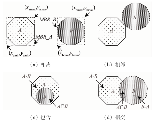
Abstract  

In order to effectively carry out remote sensing monitoring work of mine geological environment restoration and management, the authors established a model for dynamic change detection of vector data, and proposed an automatic method for change detection of vector result data, which is suitable for the change of mine geological features. According to the spatial topological relationship and the attribute change situation of different temporal vector result data, the dynamic change of elements is automatically analyzed and detected, and the plug-in application framework based on ArcGIS Engine (AE) is used to develop the dynamic change detection software of result data. The results show that this method improves effectively the efficiency of dynamic change detection of vector result data, reduces the workload of restoring, harnessing and mining damaged data when they are put into storage, and provides strong support for relevant departments to further monitor the recovery and management of mine geological environment.

Keywords vector result data      change detection      variation types of spatial data      mine remote sensing monitoring      plug-in development     
:  TP311  
Issue Date: 09 October 2020
Service
E-mail this article
E-mail Alert
RSS
Articles by authors
Mingguang DIAO
Wenjing LIU
Jing LI
Fang LIU
Yanzuo WANG
Cite this article:   
Mingguang DIAO,Wenjing LIU,Jing LI, et al. Dynamic change detection method of vector result data in mine remote sensing monitoring[J]. Remote Sensing for Land & Resources, 2020, 32(3): 240-246.
URL:  
https://www.gtzyyg.com/EN/10.6046/gtzyyg.2020.03.31     OR     https://www.gtzyyg.com/EN/Y2020/V32/I3/240
Fig.1  Organization structure of data
属性名称 字段编码 字段类型 字段长度 约束条件 字段阈值
用户ID KFID C 18 M 综合代码
占地面积 KFZDMJ F 16位整数、2位小数 M
治理状态 ZLZT C 1 O 单一代码
治理方式 ZLFS C 100 B或C 自由文本
说明 属性名称缩写,用来描述图层特性 C为文本型;F为浮点型 面积类16位整数、2位小数;文本类不超过256位;坐标类保留6位小数 M为必填;O为选填;B为已治理;C为部分治理 包括综合代码、单一代码、代码表、自由文本。综合代码按特定规则组合;单一代码、代码表为枚举值
Tab.1  Definition of partial attribute information of vector data
Fig.2  Process of dynamic change detection
变化类型代码 变化类型 旧时态 新时态
10 新增要素
20 灭失要素
3A 延续要素增加
3B 延续要素减少
3C 延续要素不变
Tab.2  variation types of different time-state spatial data
Fig.3  Topological relationship between polygon A and B
拓扑关系 数学描述 变化类型
不相交 Ta={a|tT,oOto=ф,a=t} 10
Ob={b|oO,tTot=ф,b=o} 20
相交/包含 Tc={c|tT,oOtoф,c=t-o} 3A
Td={d|tT,oOtoф,d=to} 3C
Oe={e|oO,tTtoф,e=o-t} 3B
Tab.3  Mathematical description of variation types
Fig.4  Metadata management model
Fig.5  Application framework architecture based on AE
Fig.6  Dynamic change detection model
Fig.7  Development of land-occupied vector data in 2015,2016
Fig.8  Five kinds of change detection results
Fig.9  Dynamic change detection results
[1] 杨金中, 聂洪峰, 荆青青. 初论全国矿山地质环境现状与存在问题[J]. 国土资源遥感, 2017,29(2):1-7.doi: 10.6046/gtzyyg.2017.02.01.
[1] Yang J Z, Nie H F, Jing Q Q. Preliminary analysis of mine geo-environment status and existing problems in China[J]. Remote Sensing for Land and Resources, 2017,29(2):1-7.doi: 10.6046/gtzyyg.2017.02.01.
[2] Worboys M, Duckham M. Monitoring qualitative spatiotemporal change for geosensor networks[J]. International Journal of Geographical Information Science, 2016,20(10):1087-1108.
[3] 杨金中, 秦绪文, 张志, 等. 矿山遥感监测理论方法与实践[M]. 北京: 测绘出版社, 2011: 147-155.
[3] Yang J Z, Qin X W, Zhang Z, et al. Theory and practice on remote sensing monitoring of mine[M] Beijing: Surveying and Mapping Publishing House, 2011: 147-155.
[4] 中国自然资源航空物探遥感中心. 矿山遥感监测成果数据入库要求(2017版)[Z]. 北京:中国自然资源航空物探遥感中心, 2017.
[4] China Aero Geophysical Survey and Remote Sensing Center for Natural Resources. Production for data requirements for database of mine remote sensing monitoring(2017)[Z]. Beijing:China Aero Geophysical Survey and Remote Sensing Center for Natural Resources, 2017.
[5] 刁明光, 李静, 杨清松, 等. 遥感监测矢量成果数据要素分区域自动划分方法[J]. 中国科技论文, 2018,13(15):1749-1753.
[5] Diao M G, Li J, Yang Q S, et al. Automatically dividing method of data elements in remote sensing monitoring vector results data[J]. China Sciencepaper, 2018,13(15):1749-1753.
[6] 刁明光, 瞿翟, 薛涛, 等. 基于AE插件式矿山遥感监测成果数据质量检查系统[J]. 国土资源遥感, 2017,29(4):219-224.doi: 10.6046/gtzyyg.2017.04.33.
[6] Diao M G, Qu D, Xue T, et al. Plug-in style results data quality checking system for mine remote sensing monitoring based on AE[J]. Remote Sensing for Land and Resources, 2017,29(4):219-224.doi: 10.6046/gtzyyg.2017.04.33.
[7] 刁明光, 薛涛, 梁建东, 等. 矿山遥感监测属性数据复杂约束类型的描述方法[J]. 国土资源遥感, 2016,28(3):197-201.doi: 10.6046/gtzyyg.2016.04.30.
[7] Diao M G, Xue T, Liang J D, et al. Description method for complex constraint of mine remote sensing monitoring attribute data[J]. Remote Sensing for Land and Resources, 2016,28(3):197-201.doi: 10.6046/gtzyyg.2016.04.30.
[8] 刁明光, 薛涛, 李建存, 等. 基于ArcGIS的矿山遥感监测成果编制系统[J]. 国土资源遥感, 2016,28(3):194-199.doi: 10.6046/gtzyyg.2016.03.30.
doi: 10.6046/gtzyyg.2016.03.30 url: http://www.gtzyyg.com/CN/abstract/abstract2029.shtml
[8] Diao M G, Xue T, Li J C, et al. Production data compilation system of mine remote sensing monitoring based on ArcGIS[J]. Remote Sensing for Land and Resources, 2016,28(3):194-199.doi: 10.6046/gtzyyg.2016.03.30.
[9] 彭崧. 基于XSD转换技术的数据交换实现[J].科技广场, 2012(4):51-53.
[9] Peng S. Realization of data exchange based on the XSD conversion technology[J].Science Mosaic 2012(4):51-53.
[10] 蔚晓娟, 冉静, 李爱华, 等. 基于DOM的XML解析与应用[J].计算机技术与发展, 2007(4):86-88,139.
url: http://d.wanfangdata.com.cn/Periodical_wjfz200704024.aspx
[10] Wei X J, Ran J, Li A H, et al. XML parse and application based on DOM[J].Computer Technology and Development 2007(4):86-88,139.
[11] 孙丽, 高飞, 胡小华, 等. ArcEngine插件式GIS二次开发框架的设计与实现[J]. 测绘科学, 2011,36(5):214-216.
[11] Sun L, Gao F, Hu X H, et al. Design and realization of framework for plug-in GIS secondary development based on ArcEngine[J]. Science of Surveying and Mapping, 2011,36(5):214-216.
[12] 张毅, 李国卿, 赵军喜, 等. 插件式GIS应用框架关键技术研究[J]. 测绘科学技术学报, 2010,27(4):298-301.
[12] Zhang Y, Li G Q, Zhao J X, et al. Key technology of plugin-based GIS application framework[J]. Journal of Geomatics Science and Technology, 2010,27(4):298-301.
[1] XUE Bai, WANG Yizhe, LIU Shuhan, YUE Mingyu, WANG Yiying, ZHAO Shihu. Change detection of high-resolution remote sensing images based on Siamese network[J]. Remote Sensing for Natural Resources, 2022, 34(1): 61-66.
[2] PAN Jianping, XU Yongjie, LI Mingming, HU Yong, WANG Chunxiao. Research and development of automatic detection technologies for changes in vegetation regions based on correlation coefficients and feature analysis[J]. Remote Sensing for Natural Resources, 2022, 34(1): 67-75.
[3] LI Yikun, YANG Yang, YANG Shuwen, WANG Zihao. A change vector analysis in posterior probability space combined with fuzzy C-means clustering and a Bayesian network[J]. Remote Sensing for Natural Resources, 2021, 33(4): 82-88.
[4] WANG Yiuzhu, HUANG Liang, CHEN Pengdi, LI Wenguo, YU Xiaona. Change detection of remote sensing images based on the fusion of co-saliency difference images[J]. Remote Sensing for Natural Resources, 2021, 33(3): 89-96.
[5] CHEN Dong, YAO Weiling. Automatic numbering and method improvement of mine patches based on ArcPy and custom ArcToolbox[J]. Remote Sensing for Land & Resources, 2021, 33(2): 262-269.
[6] XU Rui, YU Xiaoyu, ZHANG Chi, YANG Jin, HUANG Yu, PAN Jun. Building change detection method combining Unet and IR-MAD[J]. Remote Sensing for Land & Resources, 2020, 32(4): 90-96.
[7] Chunsen ZHANG, Rongrong WU, Guojun LI, Weihong CUI, Chenyi FENG. High resolution remote sensing image object change detection based on box-plot method[J]. Remote Sensing for Land & Resources, 2020, 32(2): 19-25.
[8] Yuting YANG, Hailan CHEN, Jiaqi ZUO. Remote sensing monitoring of impervious surface percentage in Hangzhou during 1990—2017[J]. Remote Sensing for Land & Resources, 2020, 32(2): 241-250.
[9] Xi LIU, Lina HAO, Xianhua YANG, Jie HUANG, Zhi ZHANG, Wunian YANG. Research and implementation of rapid statistical methods for mine remote sensing monitoring indicators[J]. Remote Sensing for Land & Resources, 2020, 32(2): 259-265.
[10] Linyan FENG, Bingxiang TAN, Xiaohui WANG, Xinyun CHEN, Weisheng ZENG, Zhao QI. Object-oriented rapid forest change detection based on distribution function[J]. Remote Sensing for Land & Resources, 2020, 32(2): 73-80.
[11] Yizhi LIU, Huarong LAI, Dingwang ZHANG, Feipeng LIU, Xiaolei JIANG, Qing’an CAO. Change detection of high resolution remote sensing image alteration based on multi-feature mixed kernel SVM model[J]. Remote Sensing for Land & Resources, 2019, 31(1): 16-21.
[12] Zhan ZHAO, Wang XIA, Li YAN. Land use change detection based on multi-source data[J]. Remote Sensing for Land & Resources, 2018, 30(4): 148-155.
[13] Lijuan WANG, Xiao JIN, Hujun JIA, Yao TANG, Guochao MA. Change detection for mine environment based on domestic high resolution satellite images[J]. Remote Sensing for Land & Resources, 2018, 30(3): 151-158.
[14] Xinran ZHU, Bo WU, Qiang ZHANG. An improved CVAPS method for automatic updating of LUCC classification[J]. Remote Sensing for Land & Resources, 2018, 30(2): 29-37.
[15] Guanghui WANG, Jianlei LI, Huabin WANG, Huachao YANG. Change detection based on adaptive fusion of multiple features[J]. Remote Sensing for Land & Resources, 2018, 30(2): 93-99.
Viewed
Full text


Abstract

Cited

  Shared   
  Discussed   
京ICP备05055290号-2
Copyright © 2017 Remote Sensing for Natural Resources
Support by Beijing Magtech