Please wait a minute...
 
Remote Sensing for Land & Resources    2020, Vol. 32 Issue (4) : 105-110     DOI: 10.6046/gtzyyg.2020.04.15
|
A study of crop planting type recognition based on SAR and optical remote sensing data
JIANG Shan1,2(), WANG Chun2,3, SONG Hongli1, LIU Yufeng2
1. School of Geosciences and Engineering, Hebei University of Engineering, Handan 056000, China
2. Anhui Key Laboratory of Physical Geography and Environment of Chuzhou University, Chuzhou 239000, China
3. School of Remote Sensing and Mapping Engineering, Nanjing University of Information Engineering, Nanjing 210044, China
Download: PDF(6183 KB)   HTML
Export: BibTeX | EndNote | Reference Manager | ProCite | RefWorks    
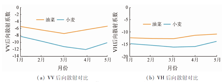
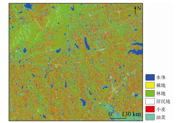
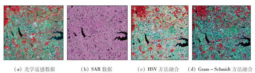
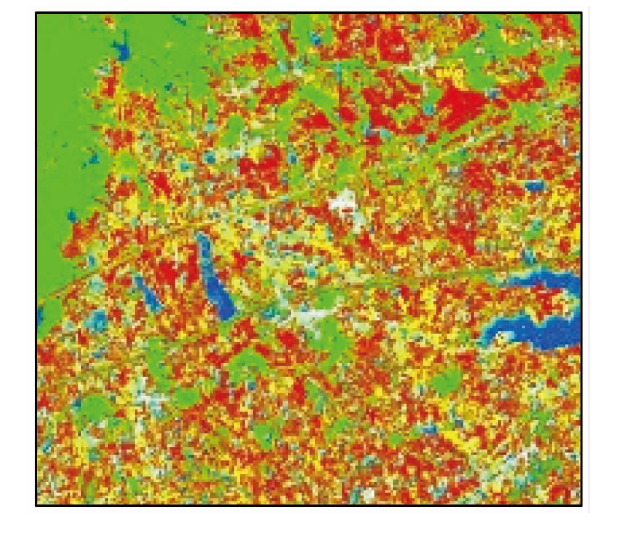
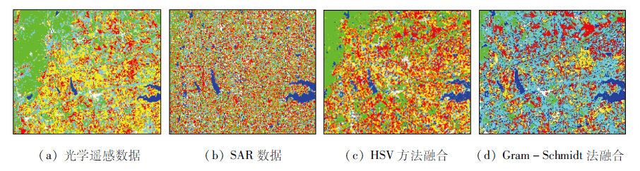
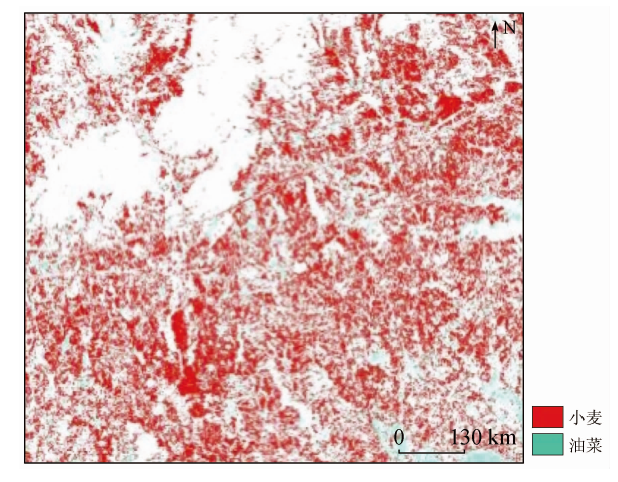
Abstract  

In order to acquire the appropriate remote sensing data to obtain the plant growth information and identify the planting types of crops, the authors chose Quanjiao of Chuzhou in Anhui Province as the research area and the SAR (GF-3) data and optical remote sensing data as the data source to fuse optical data with the SAR data and make a comparative study of data classification results, optical and SAR data classification results and the data fusion results so as to conduct crop type identification. The comparison of the data of classification results reveals that SAR data can be used as a good auxiliary optical image for crop planting types in crop recognition. The fusion of SAR data and optical remote sensing data has a good identification effect on crops in the research area.

Keywords synthetic aperture Radar (SAR)      crop recognition      fusion      classification     
:  TP79  
Issue Date: 23 December 2020
Service
E-mail this article
E-mail Alert
RSS
Articles by authors
Shan JIANG
Chun WANG
Hongli SONG
Yufeng LIU
Cite this article:   
Shan JIANG,Chun WANG,Hongli SONG, et al. A study of crop planting type recognition based on SAR and optical remote sensing data[J]. Remote Sensing for Land & Resources, 2020, 32(4): 105-110.
URL:  
https://www.gtzyyg.com/EN/10.6046/gtzyyg.2020.04.15     OR     https://www.gtzyyg.com/EN/Y2020/V32/I4/105
Fig.1  Schematic diagram of study area
Fig.2  Research area after SAR data processing
农作物波段 1号 2号 3号 4号 5号 6号 7号 8号
油菜蓝光波段 626 631 672 672 710 728 730 769
小麦蓝光波段 493 540 552 557 560 562 563 592
油菜绿光波段 928 979 992 992 1 010 1 027 1 059 1 167
小麦绿光波段 685 728 734 762 777 835 836 869
油菜红光波段 1 293 1 327 1 347 1 379 1 391 1 419 1 485 1 496
小麦红光波段 1 020 1 027 1 041 1 068 1 193 1 196 1 198 1 250
油菜近红外波段 2 513 2 526 2 605 2 660 2 666 2 681 2 690 2 749
小麦近红外波段 1 731 1 909 2 070 2 373 2 439 2 587 2 654 2 630
Tab.1  Reflectance value of wheat and rape of different waves
Fig.3  Spectral reflectance curve of crops
Fig.4  Regional achievement by optical remote sensing classification
土地覆盖
类型
1月中旬 2月中旬 3月中旬 4月中旬 5月中旬
VV VH VV VH VV VH VV VH VV VH
小麦 -8.2 -14.8 -9.6 -15.5 -11.1 -16.2 -11.9 -16.0 -10.0 -13.9
油菜 -5.4 -12.4 -6.4 -12.7 -7.4 -12.8 -6.3 -11.4 -5.3 -10.9
Tab.2  Comparison of backscatter of wheat and rape with different polarization
Fig.5  Line chart of different polarization backscattering of wheat and rape
Fig.6  Local result by SAR data classification
Fig.7  Comparison before and after data fusion
Fig.8  Local result after image classification fusion based on HSV method
Fig.9  Local result after image classification based on Gram-Schmid fusion
土地覆盖类型 训练样本像素数 验证样本
水体 5 181 4 565
裸地 1 605 1 422
林地 3 781 3 238
居民地 2 071 2 272
Tab.3  Pixel number of training and verification samples for reference figures(个)
土地覆盖类型 训练样本像素数 验证样本
小麦 2 003 277
油菜 976 778
Tab.4  Pixel number of training samples and validation samples of wheat and rape(个)
类别 光学 SAR HSV融合 Gram-Schmidt
融合
小麦用户精度/% 41.24 27.84 80.36 63.66
油菜用户精度/% 37.10 14.67 96.79 69.32
小麦漏分误差/% 43.04 51.17 12.52 24.51
油菜漏分误差/% 64.65 73.26 30.61 41.79
小麦制图精度/% 56.96 48.83 87.48 75.49
油菜制图精度/% 35.35 26.74 69.39 58.21
总体分类精度/% 73.02 58.57 86.29 96.20
Kappa系数 0.659 7 0.477 2 0.816 4 0.949 0
Tab.5  Classification accuracy evaluation
Fig.10  Classification results
Fig.11  Local results of wheat and rape classification
[1] 洪韬. 基于光学遥感影像的特定目标检测及识别[D]. 成都:电子科技大学, 2018.
[1] Hong T. Detection and recognition of specific targets based on optical remote sensing image[D]. Chengdu:University of Electronic Science and Technology, 2018.
[2] 周涛, 潘剑君, 韩涛, 等. 基于多时相合成孔径雷达与光学影像的冬小麦种植面积提取[J]. 农业工程学报, 2017,33(10):215-221.
[2] Zhou T, Pan J J, Han T, et al. Extraction of winter wheat planting area based on multi temporal SAR and optical image[J]. Transactions of the Chinese Society of Agricultural Engineering, 2017,33(10):215-221.
[3] Gang H, Zhang A N, Zhou F Q, et al. Integration of optical and synthetic aperture Radar (SAR) images to differentiate grassland and alfalfa in prairie area[J]. International Journal of Applied Earth Observation and Geoinformation, 2014,28:12-19.
doi: 10.1016/j.jag.2013.10.003 url: http://dx.doi.org/10.1016/j.jag.2013.10.003
[4] Jia K, Li Q Z, Tian Y C, et al. Crop classification using multi-configuration SAR data in the North China Plain[J]. Information Journal of Remote Sensing, 2012,33(1/2):170-183.
[5] 东朝霞, 王迪, 周清波, 等. 基于SAR遥感的北方旱地秋收作物识别研究[J]. 中国农业资源与区划, 2016,37(8):27-36.
[5] Dong C X, Wang D, Zhou Q B, et al. Identification of autumn harvest crops in northern dry land based on SAR remote sensing[J]. Journal of China Agricultural Resources and Regional Planning, 2016,37(8):27-36.
[6] 王迪, 周清波, 陈仲新, 等. 基于合成孔径雷达的农作物识别研究进展[J]. 农业工程学报, 2014,30(16):203-212.
[6] Wang D, Zhou Q B, Chen Z X, et al. Research progress of crop reco-gnition based on SAR[J]. Transactions of the Chinese Society of Agricultural Engineering, 2014,30(16):203-212.
[7] 胡九超. 基于高分辨率合成孔径雷达(SAR)的高原山区烟草识别方法研究[D]. 贵阳:贵州师范大学, 2015.
[7] Hu J C. Research on tobacco identification method based on high resolution synthetic aperture Radar (SAR) in plateau mountainous area[D]. Guiyang:Guizhou Normal University, 2015.
[8] 程千, 王崇倡, 张继超. RADARSAT-2全极化SAR数据地表覆盖分类[J]. 测绘工程, 2015,24(4):61-65.
[8] Cheng Q, Wang C C, Zhang J C. Surface coverage classification of RADARSAT-2 full polarization SAR data[J]. Engineering of Surveying and Mapping, 2015,24(4):61-65
[9] 王博. 星载SAR与光学数据融合处理与应用关键技术研究[D]. 武汉:武汉大学, 2015.
[9] Wang B. Research on key technologies of on-board SAR and optical data fusion processing and application[D]. Wuhan:Wuhan University, 2015.
[10] 许青云, 杨贵军, 龙慧灵, 等. 基于MODIS NDVI多年时序数据的农作物种植识别[J]. 农业工程学报, 2014,30(11):134-144.
[10] Xu Q Y, Yang G J, Long H L, et al. Crop information identification based on MODIS NDVI time-series data[J]. Transactions of the Chinese Society of Agricultural Engineering, 2014,30(11):134-144.
[11] 东朝霞. 基于全极化SAR数据的旱地作物识别与生物学参数反演研究[D]. 北京:中国农业科学院, 2016.
[11] Dong C X. Identification of dry land crops and inversion of biological parameters based on full polarization SAR data[D]. Beijing:Chinese Academy of Agricultural Sciences, 2016.
[12] 贺广均. 联合SAR与光学遥感数据的山区积雪识别研究[D]. 南京:南京大学, 2015.
[12] He G J. Snow cover recognition in mountainous areas using SAR and optical remote sensing data[D]. Nanjing:Nanjing University, 2015.
[1] SHI Feifei, GAO Xiaohong, XIAO Jianshe, LI Hongda, LI Runxiang, ZHANG Hao. Classification of wolfberry planting areas based on ensemble learning and multi-temporal remote sensing images[J]. Remote Sensing for Natural Resources, 2022, 34(1): 115-126.
[2] WU Linlin, LI Xiaoyan, MAO Dehua, WANG Zongming. Urban land use classification based on remote sensing and multi-source geographic data[J]. Remote Sensing for Natural Resources, 2022, 34(1): 127-134.
[3] LI Yuan, WU Lin, QI Wenwen, GUO Zhengwei, LI Ning. A SAR image classification method based on an improved OGMRF-RC model[J]. Remote Sensing for Natural Resources, 2021, 33(4): 98-104.
[4] FAN Yinglin, LOU Debo, ZHANG Changqing, WEI Yingjuan, JIA Fudong. Information extraction technologies of iron mine tailings based on object-oriented classification: A case study of Beijing-2 remote sensing images of the Qianxi Area, Hebei Province[J]. Remote Sensing for Natural Resources, 2021, 33(4): 153-161.
[5] BAI Junlong, WANG Zhangqiong, YAN Haitao. A K-means clustering-guided threshold-based approach to classifying UAV remote sensed images[J]. Remote Sensing for Natural Resources, 2021, 33(3): 114-120.
[6] ZHANG Aizhu, WANG Wei, ZHENG Xiongwei, YAO Yanjuan, SUN Genyun, XIN Lei, WANG Ning, HU Guang. A hierarchical spatial-temporal fusion model[J]. Remote Sensing for Natural Resources, 2021, 33(3): 18-26.
[7] JIANG Yanan, ZHANG Xin, ZHANG Chunlei, ZHONG Chengcheng, ZHAO Junfang. Classification of remote sensing images based on multi-scale feature fusion using local binary patterns[J]. Remote Sensing for Natural Resources, 2021, 33(3): 36-44.
[8] WANG Rong, ZHAO Hongli, JIANG Yunzhong, HE Yi, DUAN Hao. Application and analyses of texture features based on GF-1 WFV images in monthly information extraction of crops[J]. Remote Sensing for Natural Resources, 2021, 33(3): 72-79.
[9] LIU Wanjun, GAO Jiankang, QU Haicheng, JIANG Wentao. Ship detection based on multi-scale feature enhancement of remote sensing images[J]. Remote Sensing for Natural Resources, 2021, 33(3): 97-106.
[10] JIANG Xiao, ZHONG Chang, LIAN Zheng, WU Liangting, SHAO Zhitao. Research progress on classification criterion of geological information products based on satellite remote sensing[J]. Remote Sensing for Natural Resources, 2021, 33(3): 279-283.
[11] LING Xiao, LIU Jiamei, WANG Tao, ZHU Yueqin, YUAN Lingling, CHEN Yangyang. Application of information value model based on symmetrical factors classification method in landslide hazard assessment[J]. Remote Sensing for Land & Resources, 2021, 33(2): 172-181.
[12] LU Qi, QIN Jun, YAO Xuedong, WU Yanlan, ZHU Haochen. Buildings extraction of GF-2 remote sensing image based on multi-layer perception network[J]. Remote Sensing for Land & Resources, 2021, 33(2): 75-84.
[13] HAN Yanling, CUI Pengxia, YANG Shuhu, LIU Yekun, WANG Jing, ZHANG Yun. Classification of hyperspectral image based on feature fusion of residual network[J]. Remote Sensing for Land & Resources, 2021, 33(2): 11-19.
[14] MENG Qing, BAI Hongying, ZHAO Ting, GUO Shaozhuang, QI Guizeng. The eco-barrier effect of Qinling Mountain on aerosols[J]. Remote Sensing for Land & Resources, 2021, 33(1): 240-248.
[15] XU Yun, XU Aiwen. Classification and detection of cloud, snow and fog in remote sensing images based on random forest[J]. Remote Sensing for Land & Resources, 2021, 33(1): 96-101.
Viewed
Full text


Abstract

Cited

  Shared   
  Discussed   
京ICP备05055290号-2
Copyright © 2017 Remote Sensing for Natural Resources
Support by Beijing Magtech