|
|
 |
|

|
|
|
Urban land use classification based on remote sensing and multi-source geographic data |
WU Linlin1,2( ), LI Xiaoyan1(), MAO Dehua2, WANG Zongming2 ), LI Xiaoyan1(), MAO Dehua2, WANG Zongming2 |
1. College of Earth Sciences, Jilin University, Changchun 130012, China
2. Key Laboratory of Wetland Ecology and Environment, Northeast Institute of Geography and Agroecology, Chinese Academy of Sciences, Changchun 130102, China |
|
|
|
|
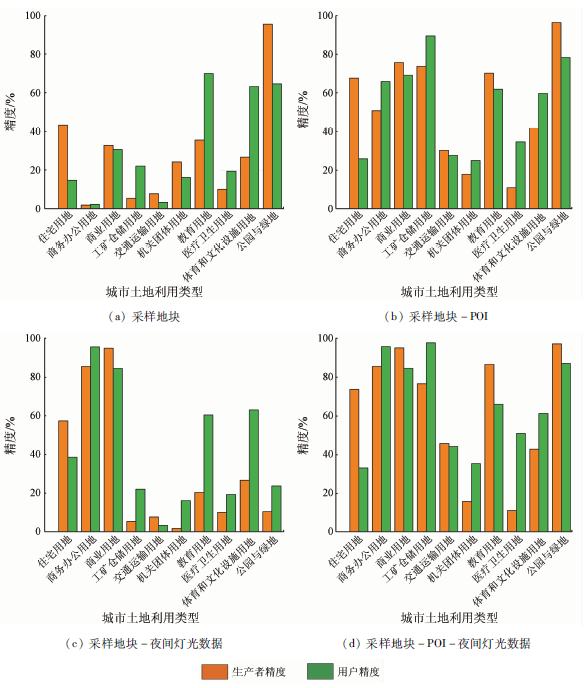
Abstract Urban land use (ULU) reflects urban functions and structures, and the study of ULU classification can provide guidance for the sustainable development of cities. This study conducted the ULU classification of the main urban area of Harbin City using the object-oriented and random forest methods by integrating multi-source geospatial data including Sentinel-2A remote sensing images, OpenStreetMap (OSM) data, point of interest (POI) data, and nighttime light data from the Luojia-1 satellite. The results are as follows. The overall accuracy of the first-level land use type was 86.0%, with a Kappa coefficient of 0.75. The overall accuracy of the second-level land use types was 73.9%, with a Kappa coefficient of 0.69. The introduction of POI data can significantly improve the classification accuracy of residential land, industrial and mining storage land, and educational land. Meanwhile, night light data can effectively improve the classification accuracy of commercial office land and business land. This study shows that the combination of remote sensing images with multi-source geographic data is effective for ULU classification.
|
| Keywords
random forest
multi-scale segmentation
multi-source data
urban land use classification
Harbin
|
|
|
|
Corresponding Authors:
LI Xiaoyan
E-mail: wull19@mails.jlu.edu.cn;lxyan@mails.jlu.edu.cn
|
|
Issue Date: 14 March 2022
|
|
|
| [1] |
Ma Q, Gong Z, Kang J, et al. Measuring functional urban shrinkage with multi-source geospatial big data:A case study of the Beijing-Tianjin-Hebei megaregion[J]. Remote Sensing, 2020, 12(16):2513.
doi: 10.3390/rs12162513
url: https://www.mdpi.com/2072-4292/12/16/2513
|
| [2] |
Mao W, Lu D, Hou L, et al. Comparison of machine-learning metho-ds for urban land-use mapping in Hangzhou City,China[J]. Remote Sensing, 2020, 12(17):2817.
doi: 10.3390/rs12172817
url: https://www.mdpi.com/2072-4292/12/17/2817
|
| [3] |
Chang S, Wang Z, Mao D, et al. Mapping the essential urban land use in Changchun by applying random forest and multi-source geospatial data[J]. Remote Sensing, 2020, 12(15):2488.
doi: 10.3390/rs12152488
url: https://www.mdpi.com/2072-4292/12/15/2488
|
| [4] |
Zhang C, Sargent I, Pan X, et al. An object-based convolutional neural network (OCNN) for urban land use classification[J]. Remote Sensing of Environment, 2018, 216:57-70.
doi: 10.1016/j.rse.2018.06.034
url: https://linkinghub.elsevier.com/retrieve/pii/S0034425718303122
|
| [5] |
Zhang C, Sargent I, Pan X, et al. Joint deep learning for land cover and land use classification[J]. Remote Sensing of Environment, 2019, 221:173-187.
doi: 10.1016/j.rse.2018.11.014
|
| [6] |
Hu T, Yang J, Li X. et al. Mapping urban land use by using Landsat images and open social data[J]. Remote Sensing, 2016, 8(2):151.
doi: 10.3390/rs8020151
url: http://www.mdpi.com/2072-4292/8/2/151
|
| [7] |
Su M, Guo R, Chen B, et al. Sampling strategy for detailed urban land use classification:A systematic analysis in Shenzhen[J]. Remote Sensing, 2020, 12(9):1497.
doi: 10.3390/rs12091497
url: https://www.mdpi.com/2072-4292/12/9/1497
|
| [8] |
Sun J, Wang H, Song Z, et al. Mapping essential urban land use categories in Nanjing by integrating multi-source big data[J]. Remote Sensing, 2020, 12(15):2386.
doi: 10.3390/rs12152386
url: https://www.mdpi.com/2072-4292/12/15/2386
|
| [9] |
He S, Chen X, Zhang Z, et al. The exploration of urban material anabolism based on RS and GIS methods:A case study in Jinchang,China[J]. Remote Sensing, 2020, 12(3):370.
doi: 10.3390/rs12030370
url: https://www.mdpi.com/2072-4292/12/3/370
|
| [10] |
Wang R, Hou H, Murayama Y, et al. Spatiotemporal analysis of land use/cover patterns and their relationship with land surface temperature in Nanjing,China[J]. Remote Sensing, 2020, 12(3):440.
doi: 10.3390/rs12030440
url: https://www.mdpi.com/2072-4292/12/3/440
|
| [11] |
Gong P, Chen B, Li X. Mapping essential urban land use categories in China (EULUC-China):Preliminary results for 2018[J]. Science Bulletin, 2020, 65(3):182-187.
doi: 10.1016/j.scib.2019.12.007
url: https://linkinghub.elsevier.com/retrieve/pii/S2095927319307054
|
| [12] |
Zong L, He S, Lian J, et al. Detailed mapping of urban land use based on multi-source data:A case study of Lanzhou[J]. Remote Sensing, 2020, 12(12):1987.
doi: 10.3390/rs12121987
url: https://www.mdpi.com/2072-4292/12/12/1987
|
| [13] |
Zeferino L B, Souza L F T D, Amaral C H D, et al. Does environmental data increase the accuracy of land use and land cover classification?[J]. International Journal of Applied Earth Observation and Geoinformation, 2020, 91:102-128.
|
| [14] |
Saboori M, Asghar T A, Reza R B H. Combining multi-scale textural features from the panchromatic bands of high spatial resolution images with ANN and MLC classification algorithms to extract urban land uses[J]. International Journal of Remote Sensing, 2019, 40(22):8608-8634.
doi: 10.1080/01431161.2019.1620371
url: https://www.tandfonline.com/doi/full/10.1080/01431161.2019.1620371
|
| [15] |
Tu Y, Chen B, Zhang T, et al. Regional mapping of essential urban land use categories in China:A segmentation-based approach[J]. Remote Sensing, 2020, 12(7):1058.
doi: 10.3390/rs12071058
url: https://www.mdpi.com/2072-4292/12/7/1058
|
| [16] |
Zhang Y, Qin K, Bi Q, et al. Landscape patterns and building functions for urban land-use classification from remote sensing images at the block level:A case study of Wuchang district,Wuhan,China[J]. Remote Sensing, 2020, 12(11):1831.
doi: 10.3390/rs12111831
url: https://www.mdpi.com/2072-4292/12/11/1831
|
| [17] |
周天宁, 明冬萍, 赵睿. 参数优化随机森林算法的土地覆盖分类[J]. 测绘科学, 2017, 42(2):88-94.
|
| [17] |
Zhou T N, Ming D P, Zhao R. Land cover classification based on parameter optimization random forest algorithm[J]. Science of Surveying and Mapping, 2017, 42(2):88-94.
|
| [18] |
马玥, 姜琦刚, 孟志国. 基于随机森林算法的农耕区土地利用分类研究[J]. 农业机械学报, 2016, 47(1):297-303.
|
| [18] |
Ma Y, Jiang Q G, Meng Z G. Research on land use classification of farming areas based on random forest algorithm[J]. Transactions of the Chinese Society of Agricultural Machinery, 2016, 47(1):297-303.
|
| [19] |
杨耘, 徐丽, 颜佩丽. 条件随机场框架下基于随机森林的城市土地利用/覆盖遥感分类[J]. 自然资源遥感, 2014, 26(4):51-55.doi: 10.6046/gtzyyg.2014.04.09.
doi: 10.6046/gtzyyg.2014.04.09
|
| [19] |
Yang Y, Xu L, Yan P L. Urban land use/cover remote sensing classification based on random forest under conditional random field framework[J]. Remote Sensing for Land and Resources, 2014, 26(4):51-55.doi: 10.6046/gtzyyg.2014.04.09.
doi: 10.6046/gtzyyg.2014.04.09
|
| [20] |
薛冰, 肖骁, 李京忠. 基于兴趣点(POI)大数据的东北城市空间结构分析[J]. 地理科学, 2020, 40(5):691-700.
doi: 10.13249/j.cnki.sgs.2020.05.003
|
| [20] |
Xue B, Xiao X, Li J Z. Spatial structure analysis of northeast cities based on big data of point of interest (POI)[J]. Geographical Sciences, 2020, 40(5):691-700.
|
| [21] |
李欣. 基于POI要素空间聚集特征的城市多中心结构识别——以郑州市为例[J]. 北京大学学报(自然科学版), 2020, 56(4):692-702.
|
| [21] |
Li X. Urban multi-center structure recognition based on the spatial aggregation characteristics of POI elements:Taking Zhengzhou as an example[J]. Acta Scientiarum Naturalium Universitatis Pekinensis, 2020, 56(4):692-702.
|
| [22] |
Brovelli M, Zamboni G. A new method for the assessment of spatial accuracy and completeness of OpenStreetMap building footprints[J]. ISPRS International Journal of Geo-Information, 2018, 7(8):289.
doi: 10.3390/ijgi7080289
url: http://www.mdpi.com/2220-9964/7/8/289
|
| [23] |
郑纪玲. 数据清洗在构建POI数据仓库中的研究与应用[D]. 北京:中国矿业大学(北京),2016.
|
| [23] |
Zheng J L. Research and application of data cleaning in the construction of POI data warehouse[D]. Beijing:China University of Mining and Technology(Beijing),2016.
|
| [24] |
陈颖彪, 郑子豪, 吴志峰, 等. 夜间灯光遥感数据应用综述和展望[J]. 地理科学进展, 2019, 38(2):205-223.
doi: 10.18306/dlkxjz.2019.02.005
|
| [24] |
Chen Y B, Zheng Z H, Wu Z F, et al. Summary and prospect of the application of nighttime light remote sensing data[J]. Progress in Geography, 2019, 38(2):205-223.
|
| [25] |
李黔湘, 郑晗, 张过, 等. 基于夜间灯光影像的珞珈一号指数分析[J]. 测绘地理信息, 2020, 45(3):8-15.
|
| [25] |
Li Q X, Zheng H, Zhang G, et al. Analysis of Luojia-1 index based on nighttime light image[J]. Geoinformation of Surveying and Mapping, 2020, 45(3):8-15.
|
| [26] |
林先成, 李永树. 成都平原高分辨率遥感影像分割尺度研究[J]. 自然资源遥感, 2010, 22(2):7-11.doi: 10.6046/gtzyyg.2010.02.02.
doi: 10.6046/gtzyyg.2010.02.02
|
| [26] |
Lin X C, Li Y S. Research on the segmentation scale of high-resolution remote sensing image of Chengdu Plain[J]. Remote Sensing for Land and Resources, 2010, 22(2):7-11.doi: 10.6046/gtzyyg.2010.02.02.
doi: 10.6046/gtzyyg.2010.02.02
|
| [27] |
王露, 刘庆元. 高分辨率遥感影像多尺度分割中最优尺度选取方法综述[J]. 测绘与空间地理信息, 2015, 38(3):166-169.
|
| [27] |
Wang L, Liu Q Y. A review of optimal scale selection methods in multi-scale segmentation of high-resolution remote sensing images[J]. Surveying and Spatial Information, 2015, 38(3):166-169.
|
| [28] |
黄欢欢, 黄万里. 基于面向对象分类方法的城市用地类型提取[J]. 福建师范大学学报(自然科学版), 2014, 30(6):96-102.
|
| [28] |
Huang H H, Huang W L. Urban land type extraction based on object-oriented classification method[J]. Journal of Fujian Normal University (Natural Science Edition), 2014, 30(6):96-102.
|
| [29] |
Woodcock C, Eand Strahler A H. The factor of scale in remote sensing[J]. Remote Sensing of Environment, 1987, 21(3):311-332.
doi: 10.1016/0034-4257(87)90015-0
url: https://linkinghub.elsevier.com/retrieve/pii/0034425787900150
|
| [30] |
李治, 杨晓梅, 孟樊, 等. 物候特征辅助下的随机森林宏观尺度土地覆盖分类方法研究[J]. 遥感信息, 2013, 28(6):48-55.
|
| [30] |
Li Z, Yang X M, Meng F, et al. Random forest macro-scale land cover classification method aided by phenological characteristics[J]. Remote Sensing Information, 2013, 28(6):48-55.
|
|
Viewed |
|
|
|
Full text
|
|
|
|
|
Abstract
|
|
|
|
|
Cited |
|
|
|
|
| |
Shared |
|
|
|
|
| |
Discussed |
|
|
|
|
 2022,
Vol. 34
2022,
Vol. 34