|
|
|
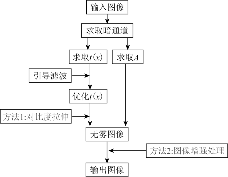
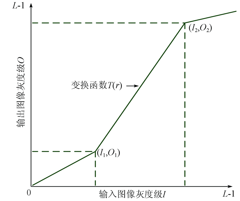
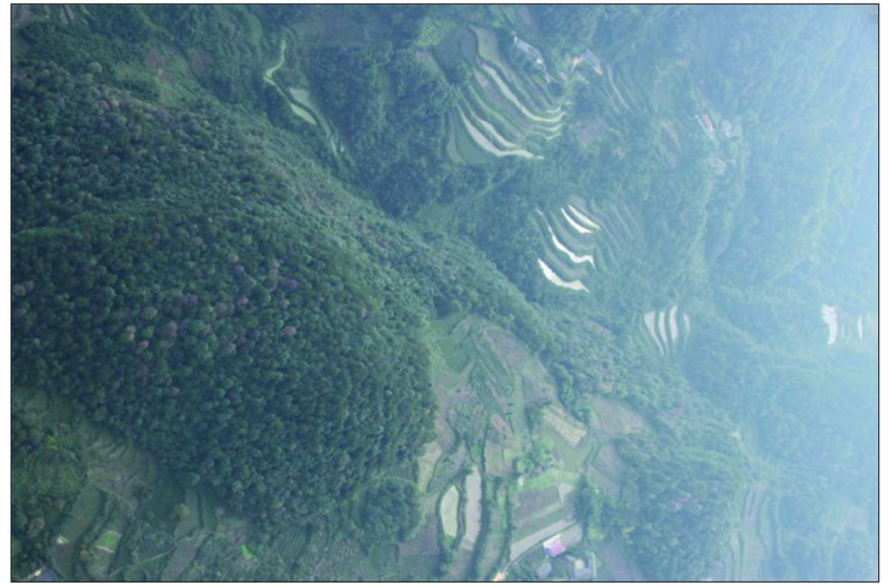
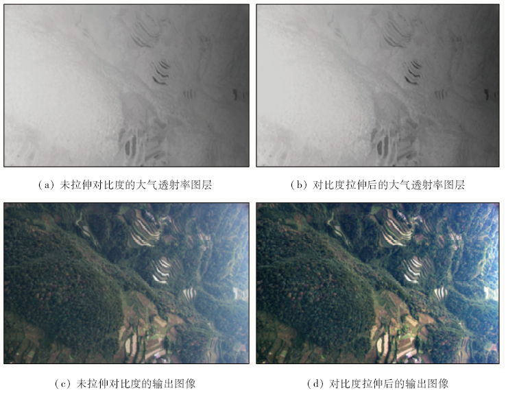
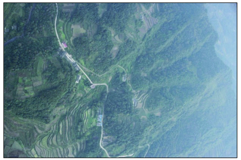
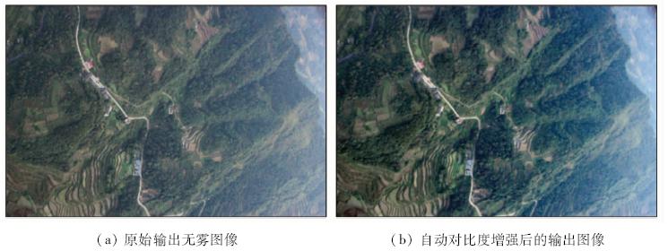
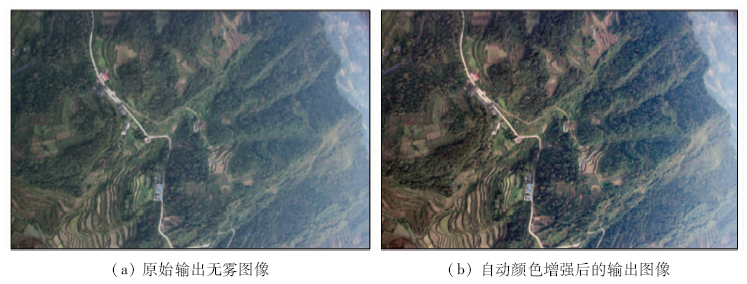
Abstract After observing a large number of aerial images, it is found that the effect is not ideal and the contrast is still not high. In this paper, through the study of the dark channel prior defogging algorithm, the process of fog image degradation is analyzed, and an aerial image defogging effect optimization method based on the dark channel prior is proposed. When the original image is uneven, the method of enhancing the contrast of atmospheric transmittance layer is used to improve the quality of the output image. In addition, for all the input images with fog, an image processing method of automatic contrast or automatic color enhancement is used to enhance the brightness of the output image. The optimization algorithm uses the objective image quality evaluation method without reference to evaluating the image effect before and after optimization. The analytical results show that, on the basis of ensuring the operation time, the optimized algorithm makes the output defog image more clear and meets the requirements of UAV aerial image data quality control.
|
| Keywords
dark channel prior
aerial image
fog removal
effect optimization
enhancement processing
|
|
|
|
Issue Date: 18 March 2021
|
|
|
| [1] |
Oakley J P, Hong B. Correction of simple contrast loss in color images[J]. IEEE Transactions on Image Processing, 2007,16(2):511-522.
pmid: 17269643
url: https://www.ncbi.nlm.nih.gov/pubmed/17269643
|
| [2] |
Oakley J P, Satherley B L. Improving image quality in poor visibility conditions using a physical model for contrast degradation[J]. IEEE Transactions on Image Processing, 1998,7(2):167-179.
pmid: 18267391
url: https://www.ncbi.nlm.nih.gov/pubmed/18267391
|
| [3] |
Tan K K, Oakley J P. Physics-based approach to color image enhancement in poor visibility conditions[J]. Journal of the Optical Society of America A-Optics, 2001,18(10):2460-2467.
|
| [4] |
Wang W, Xu L. Retinex Algorithm on changing scales for haze removal with depth map[J]. International Journal of Hybrid Information Technology, 2014,7(4):353-364.
|
| [5] |
He K, Sun J, Tang X. Single image haze removal using dark channel prior[J]. IEEE Transactions on Pattern Analysis and Machine, 2011,33(12):2341-2353.
doi: 10.1109/TPAMI.2010.168
url: http://ieeexplore.ieee.org/document/5567108/
|
| [6] |
Narasimhan S G, Nayar S K. Vision and the atmosphere[J]. International Journal of Computer Vision, 2002,48(3):233-254.
|
| [7] |
Fiveland W A. Discrete-ordinates solutions of the radiative transport equation for rectangular enclosures[J]. Journal of Heat Transfer, 1984,106(4):699-706.
|
| [8] |
郭珈, 王孝通, 胡程鹏, 等. 基于单幅图像景深和大气散射模型的去雾方法[J]. 中国图像图形学报, 2012,17(1):27-32.
|
| [8] |
Guo J, Wang X T, Hu C P, et al. Single image dehazing based on scene depth and physical model[J]. Journal of Image and Graphics, 2012,17(1):27-32.
|
| [9] |
宋勇, 蔡志平. 大数据环境下基于信息论的入侵检测数据归一化方法[J]. 武汉大学学报(理学版), 2018,64(2):121-126.
|
| [9] |
Song Y, Cai Z P. Normalized method of intrusion detection data based on information theory in big data environment[J]. Journal of Wuhan University(Natural Science Edition), 2018,64(2):121-126.
|
| [10] |
程滔, 李广泳, 毕凯. 顾及时点特征的水体提取成果空间修正方法[J]. 国土资源遥感, 2019,31(2):96-101.doi: 10.6046/gtzyyg.2019.02.14.
|
| [10] |
Cheng T, Li G Y, Bi K. Research on the geospatial correction method of water extracting products considering the characteristics of time points[J]. Remote Sensing for Land and Resources, 2019,31(2):96-101.doi: 10.6046/gtzyyg.2019.02.14.
|
| [11] |
王泽胜, 董宝田, 赵芳璨, 等. 基于改进暗通道先验的交通图像去雾新方法[J]. 控制与决策, 2018,33(3):486-490.
|
| [11] |
Wang Z S, Dong B T, Zhao F C, et al. Improved dehazing method for traffic images based on dark channel prior[J]. Control and Decision, 2018,33(3):486-490.
|
| [12] |
郑鑫, 武鹏飞, 苗锡奎, 等. 从多波段图像中获取大气透过率的测量方法[J]. 光子学报, 2017,46(7):20-28.
|
| [12] |
Zheng X, Wu P F, Miao X K. Measurement of atmospheric transmittance from multi-spectral image[J]. Acta Photonica Sinica, 2017,46(7):20-28.
|
| [13] |
韩亮, 戴晓爱, 邵怀勇, 等. 基于实地大气模式改进的大气透射率反演方法[J]. 国土资源遥感, 2016,28(4):88-92.doi: 10.6046/gtzyyg.2016.04.14.
doi: 10.6046/gtzyyg.2016.04.14
url: http://www.gtzyyg.com/CN/abstract/abstract2043.shtml
|
| [13] |
Han L, Dai X A, Shao H Y, et al. An improved method for atmospheric transmissivity inversion based on field atmospheric modes[J]. Remote Sensing for Land and Resources, 2016,28(4):88-92.doi: 10.6046/gtzyyg.2016.04.14.
|
| [14] |
杨磊. 多段线性拉伸增强算法及其FPGA实现[J]. 红外技术, 2013,35(10):642-645.
|
| [14] |
Yang L. Research on multi-segment linear stretch algorithm and its FPGA implementation[J]. Infrared Technology, 2013,35(10):642-645.
|
| [15] |
唐敏, 李永树, 李歆, 等. 无人机影像局部增强方法及其在影像匹配中的应用[J]. 国土资源遥感, 2013,25(4):53-57.doi: 10.6046/gtzyyg.2013.04.09.
doi: 10.6046/gtzyyg.2013.04.09
url: http://www.gtzyyg.com/CN/abstract/abstract1677.shtml
|
| [15] |
Tang M, Li Y S, Li X, et al. Local enhancement method and its applications to UAV image matching[J]. Remote Sensing for Land and Resources, 2013,25(4):53-57.doi: 10.6046/gtzyyg.2013.04.09.
|
| [16] |
姚丙秀, 黄亮, 许艳松. 一种结合超像素和图论的高空间分辨率遥感影像分割方法[J]. 国土资源遥感, 2019,31(3):72-79.doi: 10.6046/gtzyyg.2019.03.10.
|
| [16] |
Yao B X, Huang L, Xu Y S. A high resolution remote sensing image segmentation method based on superpixel and graph theory[J]. Remote Sensing for Land and Resources, 2019,31(3):72-79.doi: 10.6046/gtzyyg.2019.03.10.
|
| [17] |
刘经南, 曾文宪, 徐培亮. 整体最小二乘估计的研究进展[J]. 武汉大学学报(信息科学版), 2013,38(5):505-512.
|
| [17] |
Liu J N, Zeng W X, Xu P L. Overview of total least squares methods[J]. Geomatics and Information Science of Wuhan University, 2013,38(5):505-512.
|
| [18] |
袁艳春, 刘云鹏, 高宏伟. 基于边缘结构相似性的图像质量评价方法[J]. 计算机应用研究, 2015,32(9):2870-2873.
|
| [18] |
Yuan Y C, Liu Y P, Gao H W. Image quality assessment method based on edge structure similarity[J]. Application Research of Computers, 2015,32(9):2870-2873.
|
|
Viewed |
|
|
|
Full text
|
|
|
|
|
Abstract
|
|
|
|
|
Cited |
|
|
|
|
| |
Shared |
|
|
|
|
| |
Discussed |
|
|
|
|
 2021,
Vol. 33
2021,
Vol. 33
 ), HU Xiao2, PENG Jun1