|
|
 |
|
|
|
|
Quality inspection of geographic information products based on multi-source remote sensing data |
Chong LI, Haolin LI( ), Yi SHE ), Yi SHE |
| Sichuan Quality Supervision and Testing Center of Surveying and Mapping Product, Chengdu 610041, China |
|
|
|
|
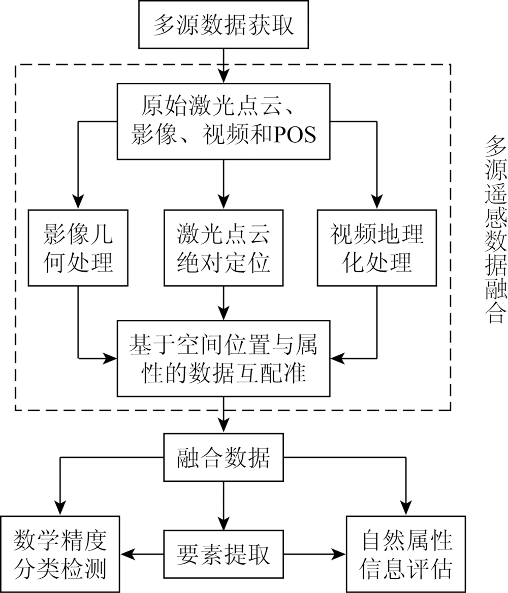
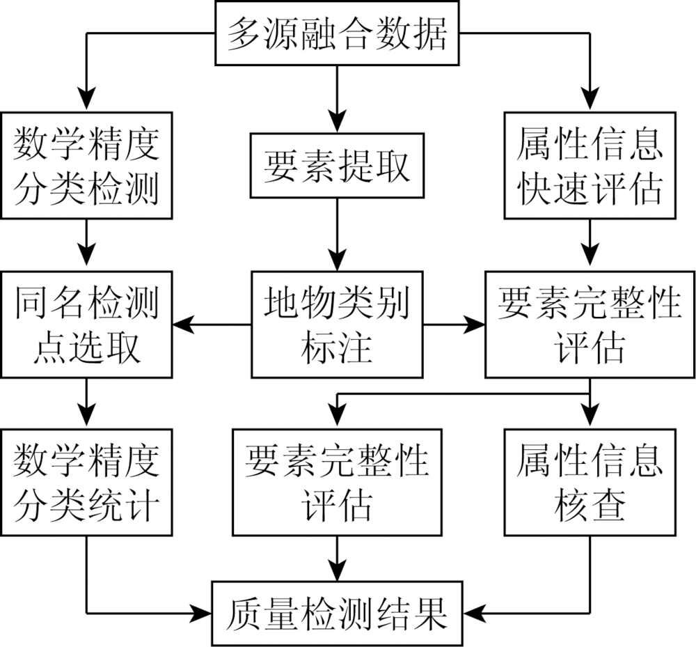
Abstract Mathematical precision, correctness of attributes and logical consistency are the main contents of current quality inspection of geographic information products. The inspection of precision and attributes mostly uses manual field inspection methods. This method has several problems: First, the acquisition of test data is discrete; second, the property correctness check is greatly affected by human factors; third, the inspection work has high labor intensity, high cost and low efficiency; fourth, it is difficult to do check and implementation work in special areas. In this paper, the technology of laser point cloud, image, video, POS (position and orientation system) and other data acquired by low-altitude drones for the third-party quality inspection of geographic information products was studied. The attribute evaluation of geographic information products based on multi-source low-altitude remote sensing data is proposed, and the method of mathematical precision classification detection is put forward. The experiment shows that the method proposed in this paper can be applied to the quality inspection of geographic information products.
|
| Keywords
LiDAR
aerial imagery
geographic information
quality inspection
accuracy detection
|
|
|
|
Corresponding Authors:
Haolin LI
E-mail: 871342021@qq.com
|
|
Issue Date: 03 December 2019
|
|
|
| [1] |
张继贤, 顾海燕 . 关于新型测绘的探索[J]. 测绘科学, 2016,41(2):3-10.
|
| [1] |
Zhang J X, Gu H Y . The exploration of new surveying and mapping[J]. Science of Surveying and Mapping, 2016,41(2):3-10.
|
| [2] |
李冲, 邓智文, 何鑫星 , 等. 信息化地理信息产品检查与评价系统构建技术[J]. 地理空间信息, 2017,15(2):12-14.
|
| [2] |
Li C, Deng Z W, He X X , et al. Quality inspection and evaluation technology for geographic information products[J]. Geospatial Information, 2017,15(2):12-14.
|
| [3] |
Teng G E, Zhou M, Li C R, et al.Mini-UAV LiDAR for power line inspection[J].ISPRS-International Archives of the Photogrammetry, Remote Sensing and Spatial Information Sciences , 2017, XLII- 2/W7:297-300.
|
| [4] |
刘正军 . 大型无人机电力线路巡检数据采集与处理技术[M]. 北京: 中国电力出版社, 2015: 177-181.
|
| [4] |
Liu Z J. Large UAV Electric Power Line Inspection Data Acquisition and Processing Technology[M]. Beijing: China Electric Power Press, 2015: 177-181.
|
| [5] |
李昊霖, 李冲, 黄瑞金 , 等. A3数码航摄仪飞行重叠度检查[J]. 遥感信息, 2015,30(6):58-62.
|
| [5] |
Li H L, Li C, Huang R J , et al. An overlap check method for A3 digital aerial camera[J]. Remote Sensing Information, 2015,30(6):58-62.
|
| [6] |
姚春静 . 机载LiDAR点云数据与遥感影像配准的方法研究[D]. 武汉:武汉大学, 2010.
|
| [6] |
Yao C J . Research on Registration of LiDAR Point Data and Remote Sensing Images[D]. Wuhan:Wuhan University, 2010.
|
| [7] |
董保根 . 机载LiDAR点云与遥感影像融合的地物分类技术研究[D]. 郑州:解放军信息工程大学, 2013.
|
| [7] |
Dong B G . Research on Classification Technologies of Land Cover by Fusing Airborne LiDAR Point Clouds and Remote Sensing Imagery[D]. Zhengzhou:Information Engineering University, 2013.
|
| [8] |
尚大帅, 马东洋, 高振峰 , 等. 机载LiDAR点云数据与影像数据融合[J]. 测绘工程, 2012,21(1):18-20.
|
| [8] |
Shang D S, Ma D Y, Gao Z F , et al. Data fusion of point cloud and aerial image derived from LiDAR system[J]. Engineering of Surveying and Mapping, 2012,21(1):18-20.
|
| [9] |
杨浩 . 基于机载LiDAR点云的真正射影像生成方法研究[D]. 绵阳:中国工程物理研究院, 2015.
|
| [9] |
Yang H . Research on Generation Method of True Ortho Based on Airborne LiDAR Point Cloud[D]. Mianyang:China Academy of Engineering Physics, 2015.
|
| [10] |
谢潇, 朱庆, 张叶廷 , 等. 多层次地理视频语义模型[J]. 测绘学报, 2015,44(5):555-562.
doi: 10.11947/j.AGCS.2015.20140176
|
| [10] |
Xie X, Zhu Q, Zhang Y T , et al. Hierarchical semantic model of geovideo[J]. Acta Geodaetica et Cartographica Sinica, 2015,44(5):555-562.
|
| [11] |
李峰, 刘文龙 . 机载LiDAR系统原理与点云处理方法[M]. 北京: 煤炭工业出版社, 2017: 54-57.
|
| [11] |
Li F, Liu W L. The Principle of Airborne LiDAR and Approaches of Processing Point Clouds[M]. Beijing: China Coal Industry Publishing House, 2017: 54-57.
|
| [12] |
闫利, 蒋宇雯 . 激光点云与航空影像融合分类[J].测绘通报,2015(10):44-46.
|
| [12] |
Yan L, Jiang Y W . Fusion classification of laser point cloud and airborne image[J].Bulletin of Surveying and Mapping,2015(10):44-46.
|
| [13] |
尚大帅 . 机载LiDAR点云数据滤波与分类技术研究[D]. 郑州:解放军信息工程大学, 2012.
|
| [13] |
Shang D S . Research on Filtering and Classification of Airborne LiDAR Data[D]. Zhengzhou:Information Engineering University, 2012.
|
| [14] |
龚亮 . 机载LiDAR点云数据分类技术研究[D]. 郑州:解放军信息工程大学, 2011.
|
| [14] |
Gong L . Research on Classification of Airborne LiDAR Data[D]. Zhengzhou:Information Engineering University, 2011.
|
|
Viewed |
|
|
|
Full text
|
|
|
|
|
Abstract
|
|
|
|
|
Cited |
|
|
|
|
| |
Shared |
|
|
|
|
| |
Discussed |
|
|
|
|
 2019,
Vol. 31
2019,
Vol. 31