|
|
|
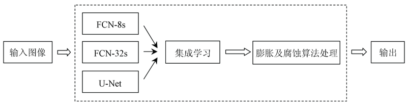
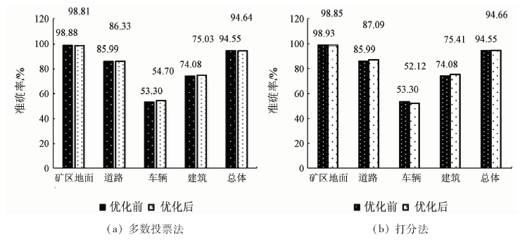
Abstract Acquisition of surface features of the mining area is greatly helpful to safe mining operation and management. In this paper, the authors propose an object-oriented combined with deep-learning classification method to extract surface features of the mining area based on unmanned aerial vehicle (UAV) images. Firstly, images are segmented by object-oriented method with manual correction to make annotation data set for deep learning models. Secondly, prepared training image data set is used to train 3 deep learning models (FCN-32s, FCN-8s and U-Net) and obtain 3 trained deep learning models respectively. Thirdly, classification accuracy is improved, and 2 integrate algorithms, which are majority voting algorithm and scoring algorithm based on these deep learning models, are proposed. The experimental results show that, compared with the single object-oriented classification method, the proposed methods have higher surface feature extraction accuracy and higher Kappa coefficient, from which the scoring integrate model has the best recognition effect. The overall accuracy of feature extraction on the testing image data set is 94.55%, which is 5.96 percentage points higher than the single object-oriented classification method, with the Kappa coefficient being 0.819 1.
|
| Keywords
UAV aerial images
object-oriented
deep learning
mining area feature extraction
semantic segmentation
|
|
|
|
Issue Date: 18 March 2021
|
|
|
| [1] |
张勇. 矿山安全监控系统的应用发展研究[J]. 石化技术, 2019(5):265-274.
|
| [1] |
Zhang Y. Research on application and development of mine safety monitoring system[J]. Petrochemical Industry Technology, 2019(5):265-274.
|
| [2] |
李娜, 李素荣, 包妮沙, 等. 基于多源遥感数据的矿区典型地物最优尺度分割研究[J]. 河北遥感, 2014(2):25-28.
|
| [2] |
Li N, Li S R, Bao N S, et al. Research on optimal scale segmentation of typical land objects based on multi-source remote sensing data[J]. Hebei Remote Sensing, 2014(2):25-28.
|
| [3] |
王飞红, 任晓敏. 基于CBERS-02B的矿区地物信息的提取[J]. 电子世界, 2013(21):121-122.
|
| [3] |
Wang F H, Reng X M. Features information extraction of the mining area based on CBERS-02B[J]. Electronics World, 2013(21):121-122.
|
| [4] |
贾玉娜, 高雅, 白洋. 基于GF-1影像的矿区地物提取与分析[J]. 山西建筑, 2019,45(5):202-203.
|
| [4] |
Jia Y N, Gao Y, Bai Y. Extraction and analysis of mining features based on GF-1[J]. Shanxi Architecture, 2019,45(5):202-203.
|
| [5] |
朱元峰, 况润元, 张刚华. 基于资源一号02C卫星影像的稀土矿区地物提取研究[J]. 江西理工大学学报, 2018,39(3):40-47.
|
| [5] |
Zhu Y F, Kuang R Y, Zhang G H. Research on the extracted information on ground objects in rare earth mining area based on ZY-1 02C image[J]. Journal of Jiangxi University of Science and Technology, 2018,39(3):40-47.
|
| [6] |
孙家波, 张晓艳, 牛鲁燕, 等. 基于高分辨率遥感影像的耕地信息快速提取方法研究[J]. 山东农业科学, 2018,50(3):132-136,141.
|
| [6] |
Sun J B, Zhang X Y, Niu L Y, et al. Farmland information extraction method based on high-resolution remotely-sensed images[J]. Shandong Agricultural Sciences, 2018,50(3):132-136,141.
|
| [7] |
荆平平, 李兵, 贾宗仁, 等. 基于无人机遥感的信息提取研究[J]. 测绘与空间地理信息, 2017,40(12):77-80.
|
| [7] |
Jing P P, Li B, Jia Z R, et al. Research on information extraction based on UAV remote Sensing[J]. Geomatics & Spatial Information Technology, 2017,40(12):77-80.
|
| [8] |
何少林, 徐京华, 张帅毅. 面向对象的多尺度无人机影像土地利用信息提取[J]. 国土资源遥感, 2013,25(2):107-112.doi: 10.6046/gtzyyg.2013.02.19
|
| [8] |
He S L, Xu J H, Zhang S Y. Land use classification of object-oriented multi-scale by UAV image[J]. Remote Sensing for Land and Resources, 2013,25(2):107-112.doi: 10.6046/gtzyyg.2013.02.19
|
| [9] |
张建勇, 赵艳玲, 肖武, 等. 利用低空无人机摄影测量快速构建矿区线状地物信息[J]. 测绘通报, 2017(10):106-110.
|
| [9] |
Zhang J Y, Zhao Y L, Xiao W, et al. Rapid construction of mine line infrastructure using low-altitude unmanned aerial vehicle photogrammetry[J]. Bulletin of Surveying and Mapping, 2017(10):106-110.
|
| [10] |
韦国钧. 基于无人机影像快速发现可疑变化地物技术研究[D]. 南京:东南大学, 2018.
|
| [10] |
Wei G J. A research on the key technology of quickly detecting suspicious changed land-use based on UAV images[D]. Nanjing:Southeast University, 2018.
|
| [11] |
徐晓萍. 无人机航测技术在矿区地形测量中的应用[J]. 资源信息与工程, 2018,33(3):114-115.
|
| [11] |
Xu X P. Application of UAV aerial surveying technology in landform measurement of mining area[J]. Resource Information and Engineering, 2018,33(3):114-115.
|
| [12] |
师文杰, 张文君. 解析无人机航空摄影测量技术在矿山地质环境治理中的应用[J]. 环球人文地理, 2017(9):81.
|
| [12] |
Shi W J, Zhang W J. Analyze the application of drone aerial photogrammetry technology in mine geological environment management[J]. Cultural Geography, 2017(9):81.
|
| [13] |
Mnih V, Hinton G E. Learning to detect roadsin high-resolution aerial images[C]// European Conference on Computer Vision.Berlin:Springer, 2010: 210-223.
|
| [14] |
郑重, 张敬东, 杜建华. 基于深度学习的遥感图像中地面塌陷识别方法研究[J]. 现代商贸工业, 2017(35):189-192.
|
| [14] |
Zheng Z, Zhang J D, Du J H. Research on ground collapse recognition in remote sensing images based on deep learning[J]. Modern Business Trade Industry, 2017(35):189-192.
|
| [15] |
向阳, 赵银娣, 董霁红. 基于改进UNet孪生网络的遥感影像矿区变化检测[J]. 煤炭学报, 2019,44(12):3773-3780.
|
| [15] |
Xiang Y, Zhao Y D, Dong J H. Remote sensing image mining area change detection based on improved UNet siamese network[J]. Journal of China Coal Society, 2019,44(12):3773-3780.
|
| [16] |
马浩然. 基于多层次分割的遥感影像面向对象森林分类[D]. 北京:北京林业大学, 2014.
|
| [16] |
Ma H R. Object-based remote sensing image classification of forest based on multi-level segmentation[D]. Beijing:Beijing Forestry University, 2014.
|
| [17] |
周龙君, 陈晓芬, 杨利娟. 面向对象标准最邻近分类法在地理国情监测中的应用[J]. 测绘与空间地理信息, 2016,39(5):155-157.
|
| [17] |
Zhou L J, Chen X F, Yang L J. Object-based standard nearest neighbor classification used in national geomatics monitoring[J]. Geomatics & Spatial Information Technology, 2016,39(5):155-157.
|
| [18] |
Long J, Shelhamer E, Darrell T. Fully convolutional networks for semantic segmentation[J]. IEEE Transactions on Pattern Analysis & Machine Intelligence, 2014,39(4):640-651.
pmid: 27244717
url: https://www.ncbi.nlm.nih.gov/pubmed/27244717
|
| [19] |
Ronneberger O, Fischer P, Brox T. U-Net:Convolutional networks for biomedical image segmentation[C]// International Conference on Medical Image Computing and Computer-Assisted Intervention.Berlin:Springer, 2015: 234-241.
|
|
Viewed |
|
|
|
Full text
|
|
|
|
|
Abstract
|
|
|
|
|
Cited |
|
|
|
|
| |
Shared |
|
|
|
|
| |
Discussed |
|
|
|
|
 2021,
Vol. 33
2021,
Vol. 33
 ), LI Qi1, LUO Yan1, QI Jiandong1