|
|
|
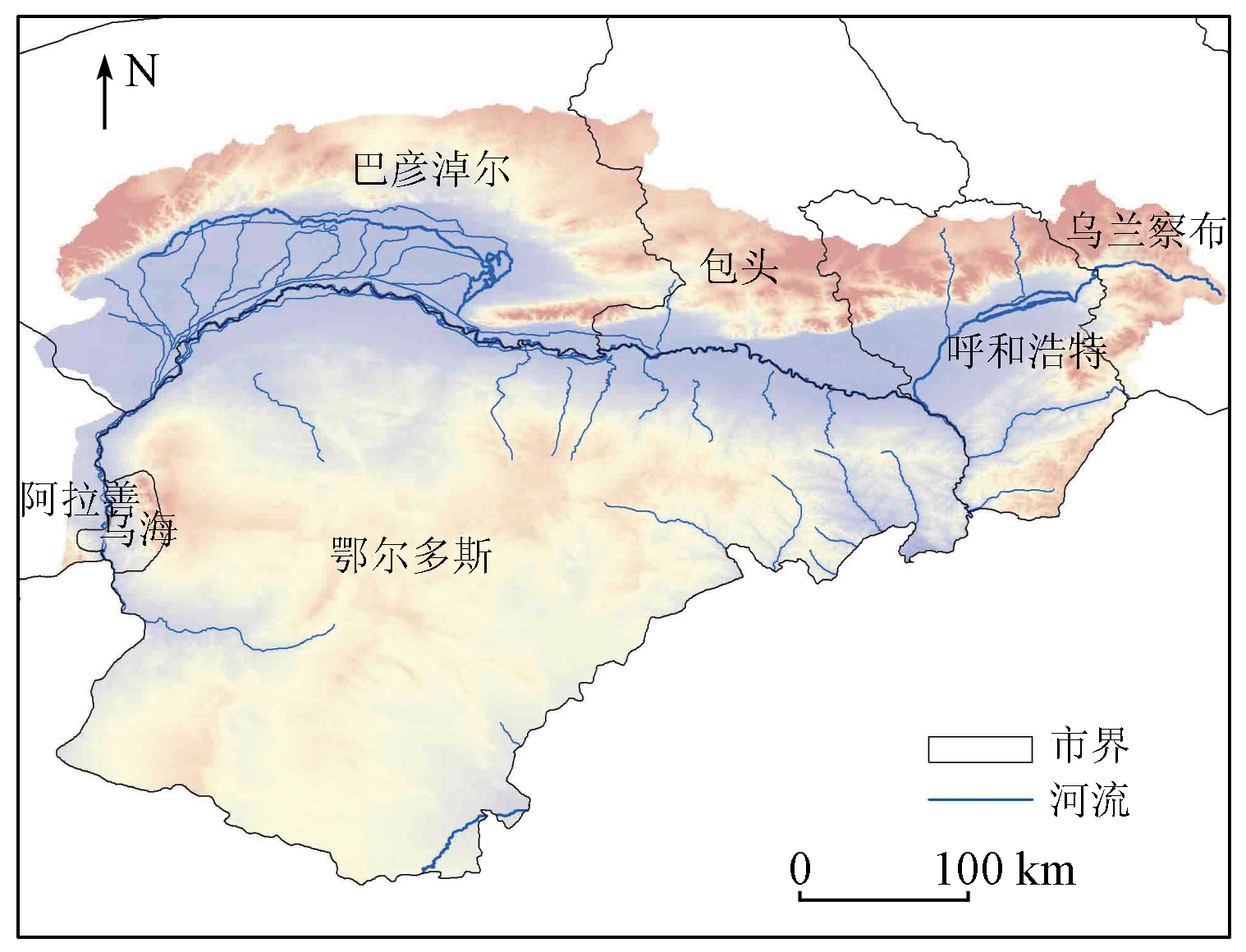
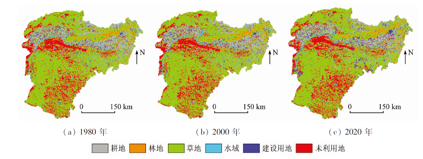
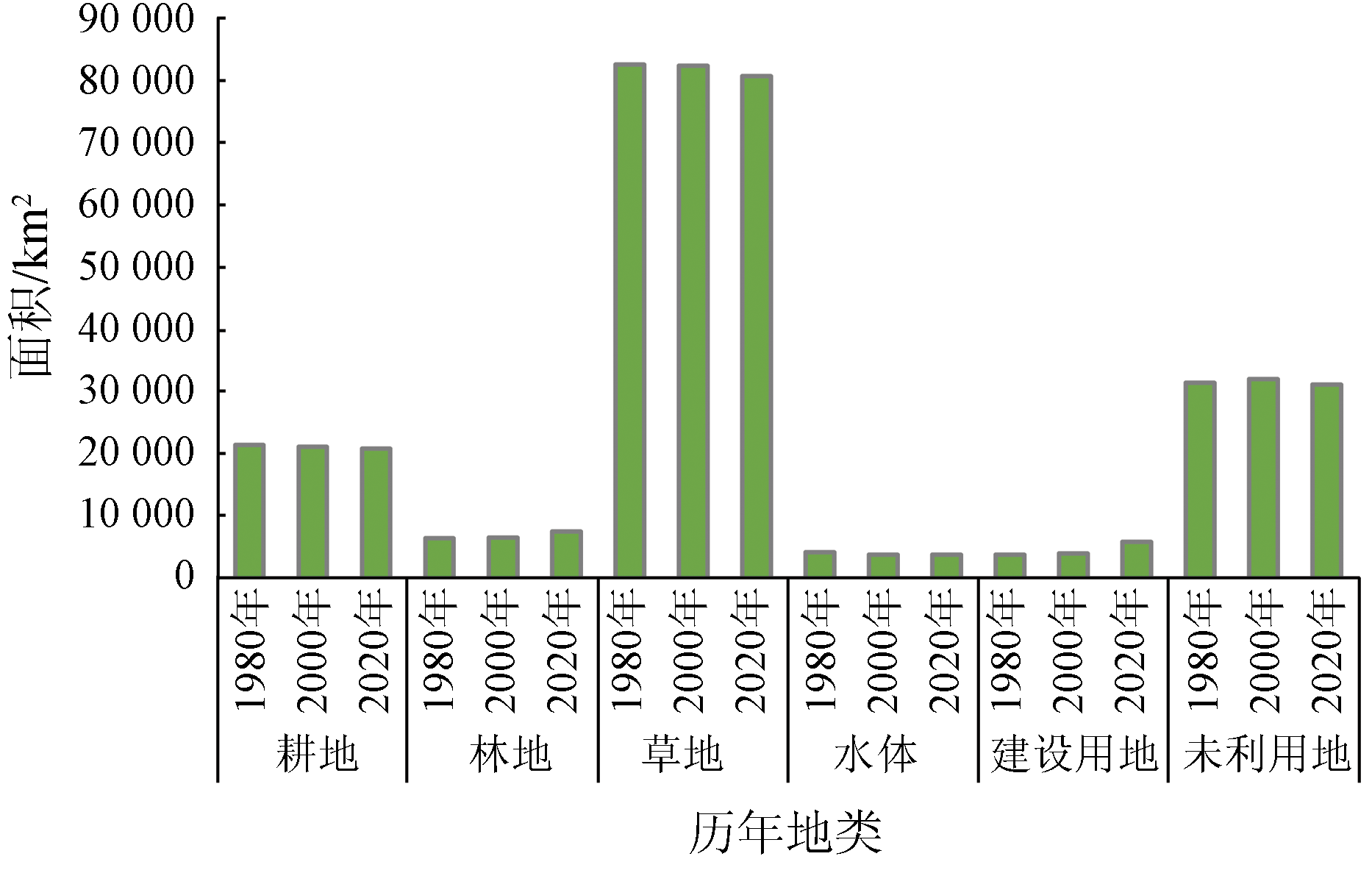
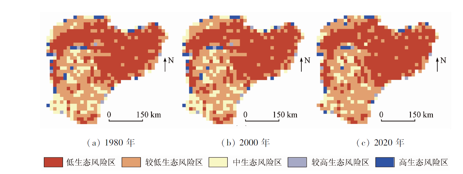
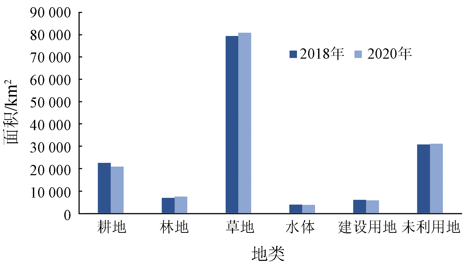
Abstract The Inner Mongolia reach of the Yellow River basin is suffering severe degradation as an ecological barrier at present. Analyzing its landscape pattern and ecological risk is of great significance for promoting the high-quality development of this reach. Based on the land use data of 1980, 2000, and 2020 of the study area, this study analyzed the spatial distribution and spatio-temporal evolution of the ecological risks by calculating the regional landscape pattern index and the ecological risk index. The results show that: ① During 1980—2020, the land in the study area was dominated by grassland, which accounted for more than 50%. In this period, the areas of cultivated land, grassland, water areas, and unused land decreased by 578 km2, 1 911 km2, 383 km2, and 255 km2, respectively. By contrast, the areas of forest land and construction land increased by 1 055 km2 and 2 072 km2, respectively. In terms of land use types, the land in the study area mainly shifted from grassland, cultivated land, and water areas to construction land and forest land. The comprehensive land use intensity during 2000—2020 was 0.85 percentage points higher than that during 1980—2000; ② During 1980—2020, the patch number of all types of land decreased except for water areas and unused land; the degree of landscape fragmentation of all types of land increased except for construction land; the degree of landscape disturbance of all types of land decreased except for forest land; the degree of landscape loss of all types of land did not change significantly except for construction land, for which the degree of landscape loss decreased significantly; ③ The ecological risk value of the Inner Mongolia reach of the Yellow River basin showed a downward trend during 1980—2020. Areas with fairly low and low ecological risks increased by 9 000 km2 in total and were primarily concentrated in the northern and central areas in this period. In contrast, areas with high and fairly high ecological risks decreased by 1 350 km2 in total and were scattered on the eastern and northern edges.
|
| Keywords
Yellow River basin in Inner Mongolia
land use
ecological landscape index
ecological risk assessment
|
|
|
|
Issue Date: 07 July 2023
|
|
|
| [1] |
陆大道, 孙东琪. 黄河流域的综合治理与可持续发展[J]. 地理学报, 2019, 74(12):2431-2436.
doi: 10.11821/dlxb201912001
|
| [1] |
Lu D D, Sun D Q. Development and management tasks of the Yellow River basin:A preliminary understanding and suggestion[J]. Acta Geographica Sinica, 2019, 74(12):2431-2436.
|
| [2] |
Schmidt P, Morrison T H. Watershed management in an urban setting:Process,scale and administration[J]. Land Use Policy, 2011, 29(1):45-52.
doi: 10.1016/j.landusepol.2011.05.003
url: https://linkinghub.elsevier.com/retrieve/pii/S0264837711000445
|
| [3] |
Wei S M, Pan J H, Liu X. Landscape ecological safety assessment and landscape pattern optimization in arid inland river basin:Take Ganzhou District as an example[J]. Human and Ecological Risk Assessment, 2020, 26(3):782-806.
doi: 10.1080/10807039.2018.1536521
url: https://www.tandfonline.com/doi/full/10.1080/10807039.2018.1536521
|
| [4] |
王洁, 摆万奇, 田国行. 土地利用生态风险评价研究进展[J]. 自然资源学报, 2020, 35(3):576-585.
doi: 10.31497/zrzyxb.20200306
|
| [4] |
Wang J, Bai W Q, Tian G H. A review on ecological risk assessment of land use[J]. Journal of Natural Resources, 2020, 35(3):576-585.
doi: 10.31497/zrzyxb.20200306
|
| [5] |
Preuss T G, Hommen U, Alix A, et al. Mechanistic effect models for ecological risk assessment of chemicals(MEMRisk):A new SETAC-Europe Advisory Group[J]. Environmental Science and Pollution Research, 2009, 16(3):250-252.
doi: 10.1007/s11356-009-0124-6
url: http://link.springer.com/10.1007/s11356-009-0124-6
|
| [6] |
Kanwarpreet S, Virender K. Hazard assessment of landslide disaster using information value method and analytical hierarchy process in highly tectonic Chamba region in bosom of Himalaya[J]. Journal of Mountain Science, 2018, 15(4):808-824.
doi: 10.1007/s11629-017-4634-2
|
| [7] |
Ayre K K, Landis W G. A Bayesian approach to landscape ecological risk assessment applied to the upper Grande Ronde watershed,Oregon[J]. Human and Ecological Risk Assessment, 2012, 18(5):946-970.
doi: 10.1080/10807039.2012.707925
url: http://www.tandfonline.com/doi/abs/10.1080/10807039.2012.707925
|
| [8] |
Cui L, Zhao Y, Liu J. Landscape ecological risk assessment in Qinling Mountain[J]. Geological Journal, 2018, 53:342-351.
doi: 10.1002/gj.v53.S1
url: http://doi.wiley.com/10.1002/gj.v53.S1
|
| [9] |
黄木易, 何翔. 近20年来巢湖流域景观生态风险评估与时空演化机制[J]. 湖泊科学, 2016, 28(4):785-793.
|
| [9] |
Huang M Y, He X. Landscape ecological risk assessment and its mechanism in Chaohu basin during the past almost 20 years[J]. Journal of Lake Sciences, 2016, 28(4):785-793.
doi: 10.18307/2016.0411
url: http://www.jlakes.org/ch/reader/view_abstract.aspx?doi=10.18307/2016.0411
|
| [10] |
Andrea D M, Simone C, Maurizio M, et al. Urban-rural ecological networks for landscape planning[J]. Land Use Policy, 2016, 50:312-327.
doi: 10.1016/j.landusepol.2015.10.004
url: https://linkinghub.elsevier.com/retrieve/pii/S0264837715003014
|
| [11] |
Xie H, Wang P, Huang H. Ecological risk assessment of land use change in the Poyang Lake Ecoeconomic Zone,China[J]. International Journal of Environmental Research and Public Health, 2013, 10(1):328-346.
doi: 10.3390/ijerph10010328
url: http://www.mdpi.com/1660-4601/10/1/328
|
| [12] |
Paukert C P, Pitts K L, Whittier J B, et al. Development and assessment of a landscape-scale ecological threat index for the Lower Colorado River basin[J]. Ecological Indicators, 2011, 11(2):304-310.
doi: 10.1016/j.ecolind.2010.05.008
url: https://linkinghub.elsevier.com/retrieve/pii/S1470160X10001019
|
| [13] |
Tian P, Li J L, Gong H B, et al. Research on land use changes and ecological risk assessment in Yongjiang River basin in Zhejiang Province,China[J]. Sustainability, 2019, 11(10):1-20.
doi: 10.3390/su11010001
url: http://www.mdpi.com/2071-1050/11/1/1
|
| [14] |
张玉娟, 曲建光, 叶猛猛. 松花江流域哈尔滨段景观生态风险评价[J]. 福州大学学报(自然科学版), 2020, 48(3):361-367.
|
| [14] |
Zhang Y J, Qu J G, Ye M M. Landscape ecological risk assessment of Harbin section of Songhua River basin[J]. Journal of Fuzhou University(Natural Science Edition), 2020, 48(3):361-367.
|
| [15] |
Chen W X, Zhao H B, Li J F, et al. Land use transitions and the associated impacts on ecosystem services in the middle reaches of the Yangtze River Economic Belt in China based on the geo-informatic Tupu method[J]. Science of the Total Environment, 2020, 701:134690.
doi: 10.1016/j.scitotenv.2019.134690
url: https://linkinghub.elsevier.com/retrieve/pii/S0048969719346819
|
| [16] |
Obery A M, Landis W G. A regional multiple stressor risk assessment of the Codorus Creek watershed the relative risk model[J]. Human and Ecological Risk Assessment, 2002, 8(2):405-428.
doi: 10.1080/20028091056980
url: https://www.tandfonline.com/doi/full/10.1080/20028091056980
|
| [17] |
乔蕻强, 程文仕, 乔伟栋, 等. 基于相对风险模型的土地利用变化生态风险定量评价——以石羊河流域为例[J]. 中国沙漠, 2017, 37(1):198-204.
doi: 10.7522/j.issn.1000-694X.2015.00163
|
| [17] |
Qiao H Q, Cheng W S, Qiao W D, et al. Evaluation of ecological risk of land use change based on the RRM model:A case in the Shiyanghe River basin[J]. Journal of Desert Research, 2017, 37(1):198-204.
doi: 10.7522/j.issn.1000-694X.2015.00163
|
| [18] |
Tang L, Ma W. Assessment and management of urbanization-induced ecological risks[J]. International Journal of Sustainable Development and World Ecology, 2018, 25(5):383-386.
doi: 10.1080/13504509.2018.1446193
url: https://www.tandfonline.com/doi/full/10.1080/13504509.2018.1446193
|
| [19] |
彭俊, 凌敏, 龚传康, 等. 基于土地利用变化的巢湖流域生态风险分析[J]. 洛阳理工学院学报(自然科学版), 2022, 32(1):4-12.
|
| [19] |
Peng J, Ling M, Gong C K, et al. Ecological risk of Chaohu Lake basin based on land use change[J]. Journal of Luoyang Institute of Science and Technology (Natural Science Edition), 2022, 32(1):4-12.
|
| [20] |
孙丽蓉, 周冬梅, 岑国璋, 等. 基于地理探测器模型的疏勒河流域景观生态风险评价及驱动因素分析[J]. 干旱区地理, 2021, 44(5):1384-1395.
|
| [20] |
Sun L R, Zhou D M, Cen G Z, et al. Landscape ecological risk assessment and driving factors of the Shule River basin based on the geographic detector model[J]. Arid Land Geography, 2021, 44(5):1384-1395.
|
| [21] |
Yan Y, Shi S N, Hu B Q, et al. Ecological risk assessment of Guangxi Xijiang River basin based on landscape pattern[J]. Ekoloji, 2018, 27(105):5-16.
|
| [22] |
朱娴飞, 陆雨婷, 吴鹏海, 等. 近三十年长江下游升金湖不同季节湿地景观生态风险时空分析[J]. 湖泊科学, 2020, 32(3):813-825.
|
| [22] |
Zhu X F, Lu Y T, Wu P H, et al. Spatial-temporal analysis of landscape ecological risk in different seasons during the past 30 years in Lake Shengjin wetland,lower reaches of the Yangtze River[J]. Journal of Lake Science, 2020, 32(3):813-825.
|
| [23] |
Hua L Z, Liao J F, Chen H X, et al. Assessment of ecological risks induced by land use and land cover changes in Xiamen City,China[J]. International Journal of Sustainable Development and World Ecology, 2018, 25(5):439-447.
doi: 10.1080/13504509.2017.1415235
url: https://www.tandfonline.com/doi/full/10.1080/13504509.2017.1415235
|
| [24] |
刘孟竹, 王彦芳, 裴宏伟. 基于土地利用变化的河北省坝上地区景观生态风险评价[J]. 水土保持通报, 2020, 40(4):303-311,345.
|
| [24] |
Liu M Z, Wang Y F, Pei H W. Landscape ecological risk assessment in Bashang area of Hebei Province based on land use change[J]. Bulletin of Soil and Water Conservation, 2020, 40(4):303-311,345.
|
| [25] |
娄妮, 王志杰, 何嵩涛. 基于景观格局的阿哈湖国家湿地公园景观生态风险评价[J]. 水土保持研究, 2020, 27(1):233-239.
|
| [25] |
Lou N, Wang Z J, He S T. Assessment on ecological risk of Aha Lake National Wetland Park beased on landscape pattern[J]. Research of Soil and Water Conservation, 2020, 27(1):233-239.
|
| [26] |
Zhou S Y, Chang J, Hu T H, et al. Spatiotemporal variations of land use and landscape ecological risk in a resource-based city,from rapid development to recession[J]. Polish Journal of Environmental Studies, 2020, 29(1):475-490.
doi: 10.15244/pjoes/102778
url: http://www.journalssystem.com/pjoes/Spatiotemporal-Variations-of-Land-Use-and-Landscape-Ecological-Risk-in-a-Resource,102778,0,2.html
|
| [27] |
Liu Y C, Liu Y X, Li J L, et al. Evolution of landscape ecological risk at the optimal scale:A case study of the Open Coastal Wetlands in Jiangsu,China[J]. International Journal of Environmental Research and Public Health, 2018, 15(8):1691.
doi: 10.3390/ijerph15081691
url: http://www.mdpi.com/1660-4601/15/8/1691
|
| [28] |
Islam M A. Contamination and ecological risk assessment of trace elements in sediments of the rivers of Sundarban mangrove forest,Bangladesh[J]. Marine Pollution Bulletin, 2017, 7(59):1-11.
doi: 10.1016/0025-326X(76)90274-5
url: https://linkinghub.elsevier.com/retrieve/pii/0025326X76902745
|
| [29] |
Wang C, Delu P. Zonin of Hangzhou Bay ecological red line using GIS-based multi-criteria decision analysis[J]. Ocean and Coastal Management, 2017, 139:42-50.
doi: 10.1016/j.ocecoaman.2017.01.013
url: https://linkinghub.elsevier.com/retrieve/pii/S0964569117300352
|
| [30] |
张文慧, 吕晓, 史洋洋, 等. 黄河流域土地利用转型图谱特征[J]. 中国土地科学, 2020, 34(8):80-88.
|
| [30] |
Zhang W H, Lyu X, Shi Y Y, et al. Graphic characteristics of land use transition in the Yellow River basin[J]. China Land Science, 2020, 34(8):80-88.
|
| [31] |
Xu K, Deng X S, Xing C B. Accuracy assessment of zenith tropospheric delay calculated from ERA5 data over China[J]. Engineering of Surveying and Mapping, 2020, 9(6):27-33.
|
| [32] |
姚海芳, 师长兴, 顾畛逵. 气候变化和人类活动对黄河上游十大孔兑水沙过程的影响[J]. 干旱区地理, 2018(3):472-479.
|
| [32] |
Yao H F, Shi C X, Gu Z K. Impacts of climate change and human activities on water discharge and sediment load of ten tributaries (the ten kongduis) of the upper Yellow River[J]. Arid Land Geo-graphy, 2018(3):472-479.
|
| [33] |
刘希朝, 李效顺, 蒋冬梅. 基于土地利用变化的黄河流域景观格局及生态风险评估[J]. 农业工程学报, 2021, 37(4):265-274.
|
| [33] |
Liu X Z, Li X S, Jiang D M. Landscape pattern identification and ecological risk assessment using land-use change in the Yellow River basin[J]. Transactions of the Chinese Society of Agricultural Engineering, 2021, 37(4):265-274.
|
|
Viewed |
|
|
|
Full text
|
|
|
|
|
Abstract
|
|
|
|
|
Cited |
|
|
|
|
| |
Shared |
|
|
|
|
| |
Discussed |
|
|
|
|
 2023,
Vol. 35
2023,
Vol. 35
 ), CHEN Jiahao1, SUN Xiaotian2, PEI Zhiyong2(