|
|
 |
|

|
|
|
A method for creating annual land cover data based on Google Earth Engine: A case study of the Yellow River basin |
FANG Mengyang1( ), LIU Xiaohuang2, KONG Fanquan1, LI Mingzhe1, PEI Xiaolong3 ), LIU Xiaohuang2, KONG Fanquan1, LI Mingzhe1, PEI Xiaolong3 |
1. Haikou Marine Geological Survey Center, China Geological Survey, Haikou 570000,China
2. Natural Resources Comprehensive Survey Command Center, China Geological Survey, Beijing 100096,China
3. Langfang Natural Resources Comprehensive Survey Center, China Geological Survey, Langfang 065000,China |
|
|
|
|
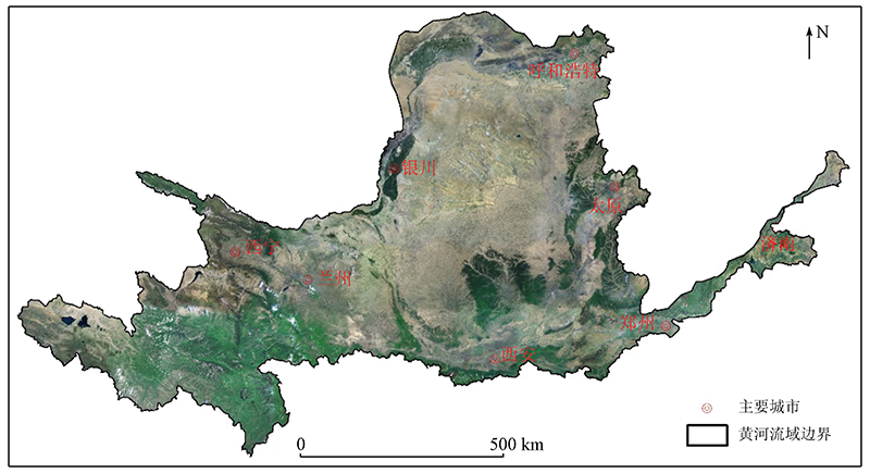
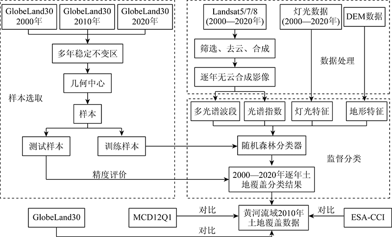
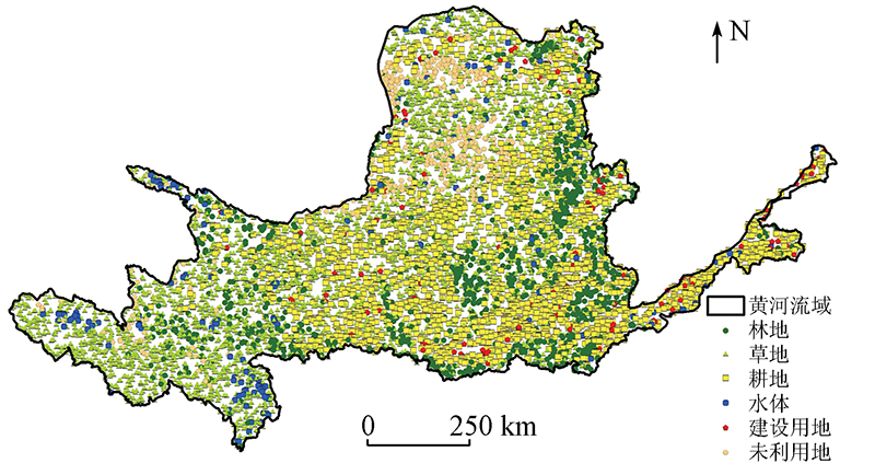
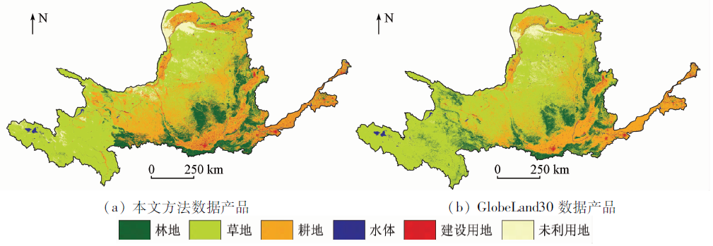
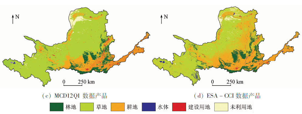
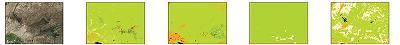
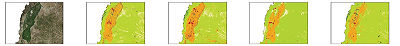
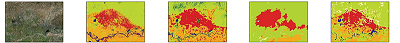
Abstract The study on many years’ land cover plays a crucial role in promoting the high-quality development of the Yellow River basin. Meanwhile, high-frequency and high-precision land cover data are vital for land cover monitoring. This study took the basin’s geometric center that has been stable for many years to sample and quickly selected a set of sample points that can be used for annual image supervised classification. Then, cloudless images were screened out from nearly one thousand Landsat images on average of the Yellow River basin of each year from 2000 to 2020 and were spliced by year using Google Earth Engine. Then, the random forest classification method was used to conduct the supervised classification of the cloudless images, producing the annual land cover data of the Yellow River basin in the recent 20 years. Finally, the land cover data of 2010 of the basin were compared with well-known annual land cover data at home and abroad. The results are as follows. ① The selection method of sample points used in this study is reasonable and reliable, with a selection accuracy of more than 94.7%, meeting the requirements of sample accuracy for supervised classification. ② The overall accuracy of the annual land cover data created based on Google Earth Engine is 0.82±0.03, with an average Kappa coefficient of 0.82. The classification accuracy and the overall and local classification results are better than the MCD12Q1 and ESA-CCI datasets. ③ Using the method for creating annual land cover data using Google Earth Engine, the frequency and accuracy of large-scale land cover data can be considered at the same time to a certain extent.
|
| Keywords
Google Earth Engine
land cover data
Yellow River basin
|
|
|
|
Issue Date: 14 March 2022
|
|
|
| [1] |
Friedl M, Sulla-Menashe D. MCD12Q1 MODIS/Terra+Aqua land cover type yearly L3 Global 500 m SIN Grid V006[DB]. NASA EOSDIS Land Processes DAAC, 2019.
|
| [2] |
Aurélie B. Global ESA CCI land cover classification map (1992—2015)[DB]. A Big Earth Data Platform for Three Poles, 2018.
|
| [3] |
Friedl M A, McIver D K, Hodges J C F, et al. Global land cover mapping from MODIS:Algorithms and early results[J]. Remote Sensing of Environment, 2002, 83(1/2):287-302.
doi: 10.1016/S0034-4257(02)00078-0
url: https://linkinghub.elsevier.com/retrieve/pii/S0034425702000780
|
| [4] |
Tsendbazar N E, De Bruin S, Fritz S, et al. Spatial accuracy assessment and integration of global land cover datasets[J]. Remote Sensing, 2015, 7(12):15804-15821.
doi: 10.3390/rs71215804
url: http://www.mdpi.com/2072-4292/7/12/15804
|
| [5] |
Chen J, Chen J, Liao A, et al. Remote sensing mapping of global land cover[M]. Beijing: Science Press, 2016.
|
| [6] |
徐新良, 刘纪远, 张树文, 等. 中国多时期土地利用土地覆被遥感监测数据集(CNLUCC)[Z]. 中国科学院资源环境科学数据中心数据注册与出版系统, 2018.
|
| [6] |
Xu X L, Liu J Y, Zhang S W, et al. China multi-period land use land cover remote sensing monitoring data set(CNLUCC)[Z]. Data Registration and Publishing System of the Resource and Environmental Science Data Center of the Chinese Academy of Sciences, 2018.
|
| [7] |
宋宏利, 张晓楠. 国家尺度异源土地覆被遥感产品精度评价[J]. 自然资源遥感, 2018, 30(3):26-32.doi: 10.6046/gtzyyg.2018.03.04.
doi: 10.6046/gtzyyg.2018.03.04
|
| [7] |
Song H L, Zhang X N. Precision validation of multi-sources land cover products derived from remote sensing[J]. Remote Sensing for Land and Resources, 2018, 30(3):26-32.doi: 10.6046/gtzyyg.2018.03.04.
doi: 10.6046/gtzyyg.2018.03.04
|
| [8] |
Hu Y F, Hu Y. Land cover changes and their driving mechanisms in central Asia from 2001 to 2017 supported by Google Earth Engine[J]. Remote Sensing, 2019, 11(5):554.
doi: 10.3390/rs11050554
url: https://www.mdpi.com/2072-4292/11/5/554
|
| [9] |
Johnson B A, Kotaro I. Integrating OpenStreetMap crowdsourced data and Landsat time-series imagery for rapid land use/land cover (LULC) mapping:Case study of the Laguna de Bay area of the Philippines[J]. Applied Geography, 2016, 67:140-149.
doi: 10.1016/j.apgeog.2015.12.006
url: https://linkinghub.elsevier.com/retrieve/pii/S0143622815300321
|
| [10] |
Manjunatha V, Nophea S, Rajendra P S, et al. Determination of vegetation thresholds for assessing land use and land use changes in Cambodia using the Google Earth Engine cloud-computing platform[J]. Remote Sensing, 2019, 11(13):1514.
doi: 10.3390/rs11131514
url: https://www.mdpi.com/2072-4292/11/13/1514
|
| [11] |
袁丽华, 蒋卫国, 申文明, 等. 2000—2010年黄河流域植被覆盖的时空变化[J]. 生态学报, 2013, 33(24):7798-7806.
|
| [11] |
Yuan L H, Jiang W G, Shen W M, et al. The spatio-temporal variations of vegetation cover in the Yellow River basin from 2000 to 2010[J]. Acta Ecologica Sinica, 2013, 33(24):7798-7806.
|
| [12] |
杨胜天, 刘昌明, 孙睿. 近20年来黄河流域植被覆盖变化分析[J]. 地理学报, 2002, 57(6):679-684.
|
| [12] |
Yang S T, Liu C M, Sun R. The vegetation cover over last 20 years in Yellow River basin[J]. Acta Geographica Sinica, 2002, 57(6):679-684.
|
| [13] |
张景华, 封志明, 姜鲁光. 土地利用/土地覆被分类系统研究进展[J]. 资源科学, 2011, 33(6):1195-1203.
|
| [13] |
Zhang J H, Feng Z M, Jiang L G. Progress on studies of land use/land cover classification systems[J]. Resources Science, 2011, 33(6):1195-1203.
|
| [14] |
胡云锋, 商令杰, 张千力, 等. 基于GEE平台的1990年以来北京市土地变化格局及驱动机制分析[J]. 遥感技术与应用, 2018, 33(4):573-583.
|
| [14] |
Hu Y F, Shang L J, Zhang Q L, et al. Land change patterns and driving mechanism in Beijing since 1990 based on GEE platform[J]. Remote Sensing Technology and Application, 2018, 33(4):573-583.
|
| [15] |
Rodriguez-Galiano V F, Chica-Olmo M, Abarca-Hernandez F, et al. Random forest classification of mediterranean land cover using multi-seasonal imagery and multi-seasonal texture[J]. Remote Sensing of Environment, 2012, 121:93-107.
doi: 10.1016/j.rse.2011.12.003
url: https://linkinghub.elsevier.com/retrieve/pii/S0034425711004408
|
| [16] |
Guo L, Chehata N, Clément M, et al. Relevance of airborne LiDAR and multispectral image data for urban scene classification using random forests[J]. ISPRS Journal of Photogrammetry and Remote Sensing, 2011, 66(1):56-66.
doi: 10.1016/j.isprsjprs.2010.08.007
url: https://linkinghub.elsevier.com/retrieve/pii/S0924271610000705
|
|
Viewed |
|
|
|
Full text
|
|
|
|
|
Abstract
|
|
|
|
|
Cited |
|
|
|
|
| |
Shared |
|
|
|
|
| |
Discussed |
|
|
|
|
 2022,
Vol. 34
2022,
Vol. 34