|
|
 |
|

|
|
|
Information extraction methods of coastal wetland based on GF-3 fully polarimetric SAR data |
HE Chenlinqiu1,2( ), CHENG Bo1(), CHEN Jinfen1,2, ZHANG Xiaoping1,2 ), CHENG Bo1(), CHEN Jinfen1,2, ZHANG Xiaoping1,2 |
1. Aerospace Information Research Institute, Chinese Academy of Sciences, Beijing 100094, China
2. University of Chinese Academy of Sciences, Beijing 100049, China |
|
|
|
|
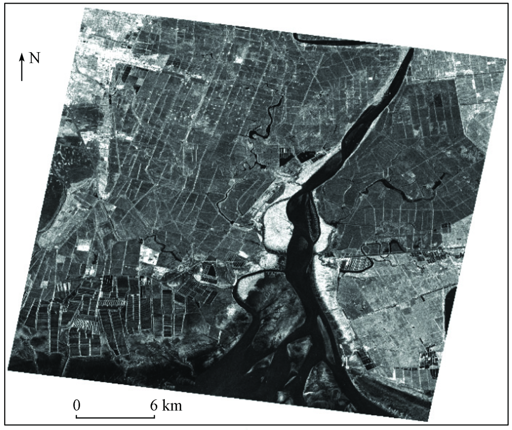
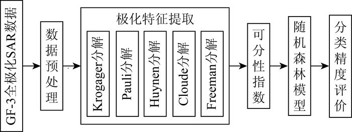
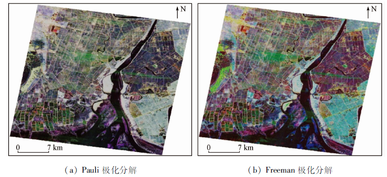
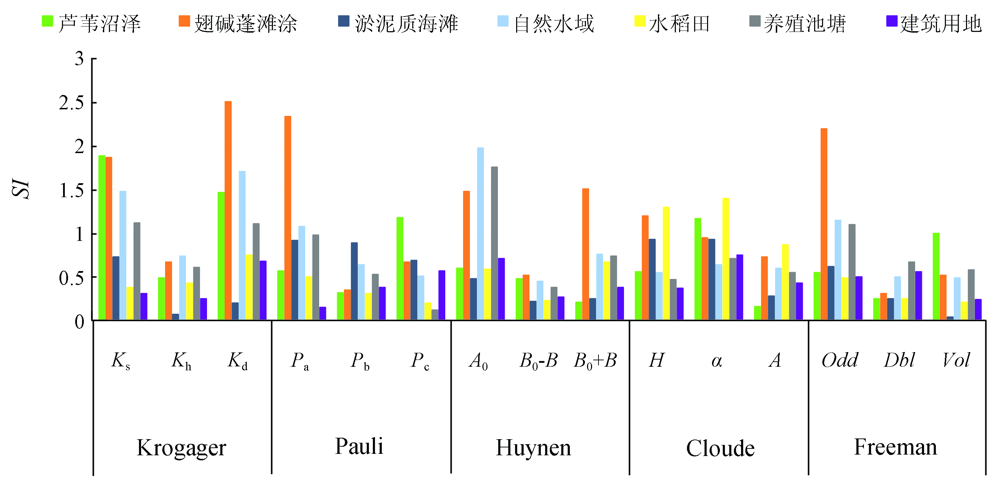
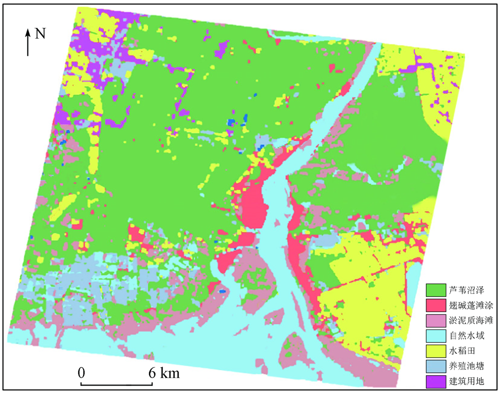
Abstract The study on the information extraction methods of coastal wetlands is highly significant for accurately grasping the distribution status of coastal wetlands and for protecting and managing the rare resources in coastal wetlands. To improve the information extraction precision of surface features in coastal wetland conservation areas, this paper screens the polarimetric decomposition features using the separability index and classifies fully polarimetric SAR images using the random forest method. The details are as follows. Based on the domestic GF-3 fully polarimetric radar images of the Liaohe River Estuary National Nature Reserve in Liaoning Province, five polarimetric target decomposition methods were used to extract polarimetric features, the separable index was adopted to optimize feature selection, and finally the random forest method was utilized to conduct the classification and accuracy assessment of surface features in the study area. The experiment results show that the classification accuracy of surface features in wetlands based on optimized polarimetric features was up to 75.47%. Meanwhile, the optimized polarimetric feature parameters can effectively avoid information redundancy and improve the information extraction accuracy of surface features in coastal wetland conservation areas.
|
| Keywords
coastal wetland
GF-3
selection of polarimetric features
|
|
|
|
Corresponding Authors:
CHENG Bo
E-mail: heclq@radi.ac.cn;chengbo@radi.ac.cn
|
|
Issue Date: 23 December 2021
|
|
|
| [1] |
刘润红, 梁士楚, 赵红艳, 等. 中国滨海湿地遥感研究进展[J]. 遥感技术与应用, 2017,32(6):998-1011.
|
| [1] |
Liu R H, Liang S C, Zhao H Y, et al. Progress of Chinese coastal wetland based on remote sensing[J]. Remote Sensing Technology and Application, 2017,32(6):998-1011.
|
| [2] |
Schmitt A, Brisco B, Kaya S, et al. Polarimetric change detection for wetlands[C]//Neale C,Cosh M.Remote Sensing and Hydrology.Oxford:IAHS Publication, 2012:375-379.
|
| [3] |
Touzi R, Deschamps A, Rother G. Wetland characterization using polarimetric Radarsat-2 capability[J]. Canadian Journal of Remote Sensing, 2007,33(s1):56-67.
|
| [4] |
Touzi R, Deschamps A, Rother G. Phase of target scattering for wetland characterization using polarimetric C-band SAR[J]. IEEE Transactions on Geoscience and Remote Sensing, 2009,47(9):3241-3261.
doi: 10.1109/TGRS.2009.2018626
url: http://ieeexplore.ieee.org/document/5067298/
|
| [5] |
陈媛媛, 何秀凤, 王静. 基于SVM的极化SAR沿海滩涂分类[J]. 地理空间信息, 2015,13(6):150-153,16.
|
| [5] |
Chen Y Y, He X F, Wang J. Polarimetric SAR classification of coastal wetland based on SVM[J]. Geospatial Information, 2015,13(6):150-153,16.
|
| [6] |
亓宁轩, 罗征宇, 李彬. 基于多波段全极化SAR影像的湿地分类[J]. 测绘与空间地理信息, 2017,40(1):171-174.
|
| [6] |
Qi N X, Luo Z Y, Li B. Multi-band polarization SAR wetlands classification[J]. Geomatics and Spatial Information Technology, 2017,40(1):171-174.
|
| [7] |
徐梦竹, 徐佳, 邓鸿儒, 等. 基于全极化SAR影像的海岛地物分类[J]. 遥感技术与应用, 2019,34(3):647-654.
|
| [7] |
Xu M Z, Xu J, Deng H R, et al. Land-use classification of islands based on fully polarimetric SAR data[J]. Remote Sensing Technology and Application, 2019,34(3):647-654.
|
| [8] |
王超, 张红, 陈曦, 等. 全极化合成孔径雷达图像处理[M]. 北京: 科学出版社, 2008:44-106.
|
| [8] |
Wang C, Zhang H, Chen X, et al. Processing of fully polarimetric synthetic aperture Radar imagery[M]. Beijing: Science Press, 2008:44-106.
|
| [9] |
国家林业局《湿地公约》履约办公室. 湿地公约履约指南[M]. 北京: 中国林业出版社, 2001.
|
| [9] |
Performance Office of China Convention on Wetlands. Guide on implementing ramsar convention in China[M]. Beijing: China Forestry Publishing House, 2001.
|
| [10] |
牟晓杰, 刘兴土, 阎百兴, 等. 中国滨海湿地分类系统[J]. 湿地科学, 2015,13(1):19-26.
|
| [10] |
Mou X J, Liu X T, Yan B X, et al. Classification system of coastal wetlands in China[J]. Wetland Science, 2015,13(1):19-26.
|
| [11] |
Huynen J R. Phenomenological theory of Radar targets[J]. Electromagnetic Scattering, 1978:653-712.
|
| [12] |
宋瑞超, 赵国忱, 卜丽静. 基于多极化特征和纹理特征的PolSAR图像分类[J]. 城市勘测, 2019(3):121-126,130.
|
| [12] |
Song R C, Zhao G C, Bu L J. PolSAR images classification based on multi-polarization feature and texture feature[J]. Urban Geotechnical Investigation and Surveying, 2019(3):121-126,130.
|
| [13] |
Cloude S R. Target decomposition theorems in Radar scattering[J]. Electronics Letters, 1985,21(1):22-24.
doi: 10.1049/el:19850018
url: https://digital-library.theiet.org/content/journals/10.1049/el_19850018
|
| [14] |
Cloude S R, Pottier E. A review of target decomposition theorems in Radar polarimetry[J]. IEEE Transactions on Geoscience and Remote Sensing, 1996,34(2):498-518.
doi: 10.1109/36.485127
url: http://ieeexplore.ieee.org/document/485127/
|
| [15] |
Cloude S R, Pottier E. An entropy based classification scheme for land applications of polarimetric SAR[J]. IEEE Transactions on Geoscience and Remote Sensing, 1997,35(1):68-78.
doi: 10.1109/36.551935
url: http://ieeexplore.ieee.org/document/551935/
|
| [16] |
Cloude S R, Papathanassiou K P. Polarimetric SAR interferometry[J]. IEEE Transactions on Geoscience and Remote Sensing, 1998,36(5):1551-1565.
doi: 10.1109/36.718859
url: http://ieeexplore.ieee.org/document/718859/
|
| [17] |
Freeman A, Durden S L. A three-component scattering model for polarimetric SAR data[J]. IEEE Transactions on Geoscience and Remote Sensing, 1998,36(3):963-973.
doi: 10.1109/36.673687
url: http://ieeexplore.ieee.org/document/673687/
|
| [18] |
赵泉华, 胡广臣, 李晓丽, 等. 基于全极化SAR影像的双台河口湿地分类及其变化分析[J]. 环境科学研究, 2019,32(2):309-316.
|
| [18] |
Zhao Q H, Hu G C, Li X L, et al. Full-polSAR image based on wetland classification and change analysis of the Shuangtai estuary wetland[J]. Research of Environmental Sciences, 2019,32(2):309-316.
|
| [19] |
万剑华, 张乃心, 任广波, 等. 典型滨海湿地植被全极化SAR显著性特征分析与融合分类[J]. 测绘地理信息, 2018,43(5):4-8.
|
| [19] |
Wan J H, Zhang N X, Ren G B, et al. Analysis and classification of fully-polarization SAR characteristics of typical vegetation in coastal wetland[J]. Journal of Geomatics, 2018,43(5):4-8.
|
| [20] |
李平, 徐新, 董浩, 等. 利用可分性指数的极化SAR图像特征选择与多层SVM分类[J]. 计算机应用, 2018,38(1):132-136,170.
|
| [20] |
Li P, Xu X, Dong H, et al. Polarimetric SAR image feature selection and multi-layer SVM classification using divisibility index[J]. Journal of Computer Applications, 2018,38(1):132-136,170.
|
| [21] |
田旸. 基于Radarsat-2时间序列的湿地水文情势遥感监测与湿地分类[D]. 哈尔滨:哈尔滨师范大学, 2017.
|
| [21] |
Tian Y. Monitoring hydrological regime and classifying the wetland based on time series Radarsat-2 images[D]. Harbin:Harbin Normal University, 2017.
|
| [22] |
潘庆榜. 兼容光学、雷达与地形辅助数据的森林湿地遥感分类[D]. 哈尔滨:哈尔滨师范大学, 2017.
|
| [22] |
Pan Q B. Remote sensing classification in forest wetland compatible with the optical,Radar and terrain aided data[D]. Harbin:Harbin Normal University, 2017.
|
| [23] |
黄瑾. 基于多波段多极化SAR数据的黄河口湿地分类研究[D]. 青岛:中国石油大学, 2011.
|
| [23] |
Huang J. Classification of the Yellow River estuary wetland based on multiband and multi-polarization SAR data[D]. Qingdao:China University of Petroleum, 2011.
|
|
Viewed |
|
|
|
Full text
|
|
|
|
|
Abstract
|
|
|
|
|
Cited |
|
|
|
|
| |
Shared |
|
|
|
|
| |
Discussed |
|
|
|
|
 2021,
Vol. 33
2021,
Vol. 33