|
|
 |
|

|
|
|
A SAR image classification method based on an improved OGMRF-RC model |
LI Yuan1,2,3,4( ), WU Lin1,2,3,5, QI Wenwen1,2,3, GUO Zhengwei1,2,3(), LI Ning1,2,3 ), WU Lin1,2,3,5, QI Wenwen1,2,3, GUO Zhengwei1,2,3(), LI Ning1,2,3 |
1. College of Computer and Information Engineering, Henan University, Kaifeng 475004, China
2. Henan Engineering Research Center of Intelligent Technology and Application, Henan University, Kaifeng 475004, China
3. Henan Key Laboratory of Big Data Analysis and Processing, Henan University, Kaifeng 475004, China
4. School of Information and Electronic Engineering, Shangqiu Institute of Technology, Shangqiu 476000, China
5. College of Environment and Planning, Henan University, Kaifeng 475004, China |
|
|
|
|
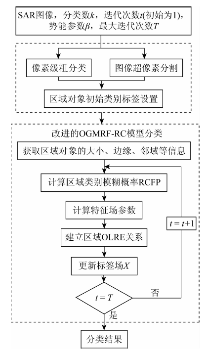
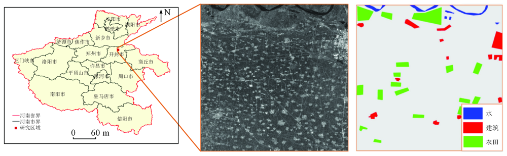
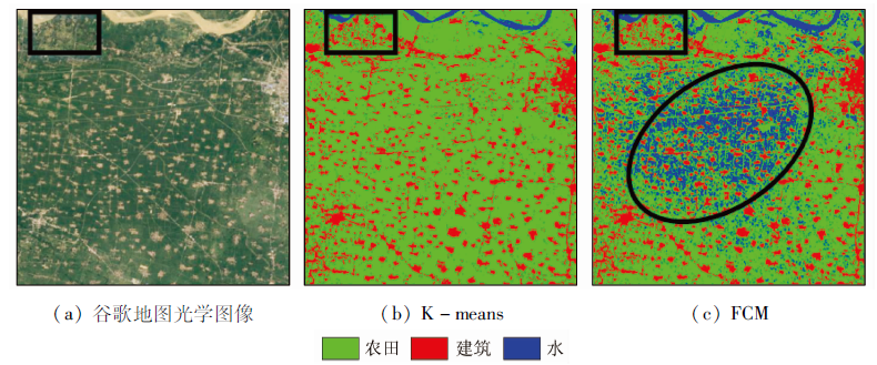
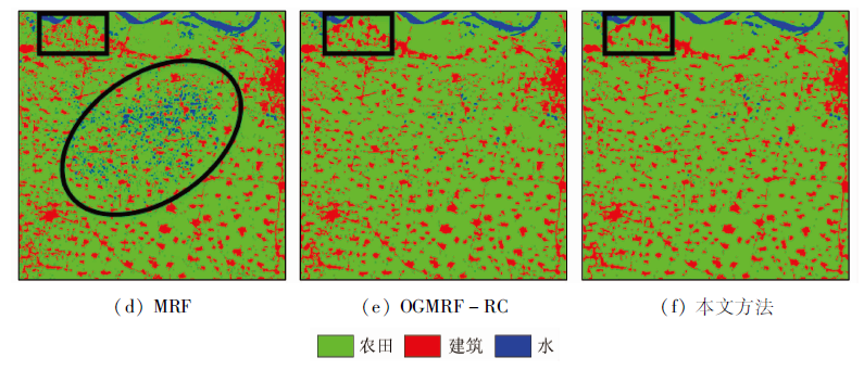
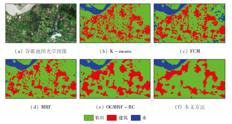
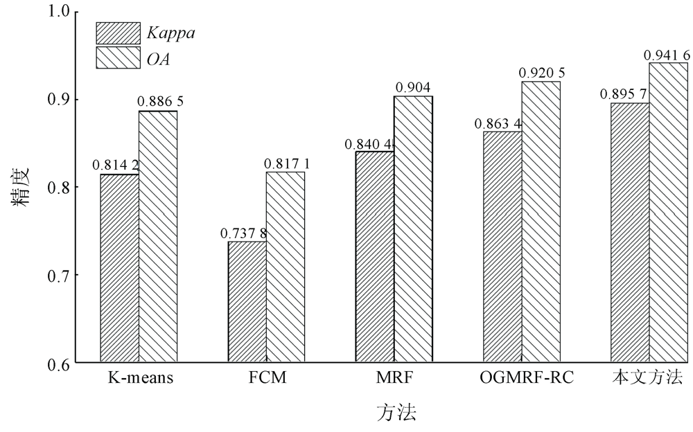
Abstract The classification of synthetic aperture Radar (SAR) images is one of the key technologies in the field of remote sensing applications. To address the problem that regional class labels affect the classification accuracy in the object-based Markov random field (OMRF) model, this paper proposes the concept of regional category fuzzy probability (RCFP) label field, which can effectively avoid the misclassification caused by wrong class labels by fully considering the possible categories of a single object. The RCFP of every region can be obtained using the regional edge information and posterior probability according to the features of the region and its adjacent regions. Then it is included in the calculation of feature field parameters to make the feature field parameters highly close to the real conditions of objects. The study area is located in the eastern part of Kaifeng City, Henan Province, covering an area of about 1 400 km2. Sentinel-1 SAR images were used for the classification experiment of farmlands, buildings, and water in the study area, and the performance of the improved method in this study was compared with that of the method of K-means, fuzzy C-means (FCM), MRF, and OGMRF-RC. The experimental results show that the overall accuracy (OA) and the Kappa coefficient of the proposed method are 94.16% and 0.8957 respectively, which are higher than those of other methods.
|
| Keywords
classification of synthetic aperture Radar (SAR) images
Markov random field (MRF)
feature filed
regional category fuzzy probability (RCFP)
Sentinel-1
|
|
|
|
Corresponding Authors:
GUO Zhengwei
E-mail: liyuan_960423@vip.henu.edu.cn;gzw@henu.edu.cn
|
|
Issue Date: 23 December 2021
|
|
|
| [1] |
范文兵, 孙志远. 基于小波域广义高斯分布的SAR图像分割算法[J]. 计算机工程与应用, 2020,56(5):222-226.
|
| [1] |
Fan W B, Sun Z Y. SAR image segmentation algorithm based on generalized gauss distribution in wavelet domain[J]. Computer Engineering and Applications, 2020,56(5):222-226.
|
| [2] |
来全, 张继权, 席宇阳, 等. 基于三聚类中心K-Means算法的SAR船只检测方法[J]. 东北师大学报(自然科学版), 2017,49(3):61-67.
|
| [2] |
Lai Q, Zhang J Q, Xi Y Y, et al. A ship detection method for SAR imagery based on three-centroid K-Means clustering algorithm[J]. Journal of Northeast Normal University(Nature Science Edition), 2017,49(3):61-67.
|
| [3] |
韩子硕, 王春平. 基于改进FCM与MRF的SAR图像分割[J]. 系统工程与电子技术, 2019,41(8):1726-1734.
|
| [3] |
Hang Z S, Wang C P. SAR image segmentation based on improved FCM and MRF[J]. Systems Engineering and Electronics, 2019,41(8):1726-1734.
|
| [4] |
国贤玉, 李坤, 王志勇, 等. 基于SVM+SFS策略的多时相紧致极化SAR水稻精细分类[J]. 国土资源遥感, 2018,30(4):20-27.doi: 10.6046/gtzyyg.2018.04.04.
doi: 10.6046/gtzyyg.2018.04.04
|
| [4] |
Guo X Y, Li K, Wang Z Y, et al. Fine classification of rice with multi-temporal compact polarimetric SAR based on SVM+SFS strategy[J]. Remote Sensing for Land and Resources, 2018,30(4):20-27.doi: 10.6046/gtzyyg.2018.04.04.
doi: 10.6046/gtzyyg.2018.04.04
|
| [5] |
Voisin A, Krylov V A, Moser G, et al. Classification of very-high resolution SAR images of urban areas using copulas and texture in a hierarchical markov random field model[J]. IEEE Geoscience and Remote Sensing Letters, 2013,10(1):96-100.
doi: 10.1109/LGRS.2012.2193869
url: http://ieeexplore.ieee.org/document/6203366/
|
| [6] |
Delia C, Ruscino S, Abbate M, et al. SAR image classification through information-theoretic textural features,MRF segmentation,and object-oriented learning vector quantization[J]. IEEE Journal of Selected Topics in Applied Earth Observations and Remote Sensing, 2014,7(4):1116-1126.
doi: 10.1109/JSTARS.4609443
url: https://ieeexplore.ieee.org/xpl/RecentIssue.jsp?punumber=4609443
|
| [7] |
Shen Y, Chen J Y, Xiao L, et al. A bilevel contextual MRF model for supervised classification of high spatial resolution remote sensing images[J]. IEEE Journal of Selected Topics in Applied Earth Observations and Remote Sensing, 2019,12(12):360-5372.
|
| [8] |
Bi H X, Xu L, Cao X, et al. Polarimetric SAR image semantic segmentation with 3D discrete wavelet transform and Markov random field[J]. IEEE Transactions on Image Processing, 2020,29:6601-6614.
doi: 10.1109/TIP.2020.2992177
url: https://ieeexplore.ieee.org/document/9106810/
|
| [9] |
Jiang X F, Zhang Y, Li Y, et al. Hyperspectral image classification with transfer learning and Markov random fields[J]. IEEE Geoscience and Remote Sensing Letters, 2020,17(3):544-548.
doi: 10.1109/LGRS.8859
url: https://ieeexplore.ieee.org/xpl/RecentIssue.jsp?punumber=8859
|
| [10] |
Lee S H. Hierarchical classification of land-cover types using RAG-based merging[C]//2007 IEEE International Geoscience and Remote Sensing Symposium, 2007:2060-2062.
|
| [11] |
Chen X H, Zheng C, Yao H T, et al. Image segmentation using a unified Markov random field model[J]. The Institution of Engineering and Technology, 2017,11(10):860-869.
|
| [12] |
Zheng C, Yao H T. Segmentation for remote-sensing imagery using the object-based Gaussian-Markov random field model with region coefficients[J]. International Journal of Remote Sensing, 2019,40(11):4441-4472.
doi: 10.1080/01431161.2018.1563841
url: https://www.tandfonline.com/doi/full/10.1080/01431161.2018.1563841
|
| [13] |
Xu X F, Zou B, Zhang L M. PolSAR image classification based on object-based Markov random field with polarimetric auxiliary label field[J]. IEEE Geoscience and Remote Sensing Letters, 2020,17(9):1558-1562.
doi: 10.1109/LGRS.8859
url: https://ieeexplore.ieee.org/xpl/RecentIssue.jsp?punumber=8859
|
| [14] |
朱阿兴, 闾国年, 周成虎, 等. 地理相似性:地理学的第三定律?[J]. 地球信息科学学报, 2020,22(4):673-679
doi: 10.12082/dqxxkx.2020.200069
|
| [14] |
Zhu A X, Lv G N, Zhou C H, et al. Geographic similarity:Third law of geography?[J]. Journal of Geo-information Science, 2020,22(4):673-679.
|
| [15] |
李智, 曲长文, 周强, 等. 基于SLIC超像素分割的SAR图像海陆分割算法[J]. 雷达科学与技术, 2017,15(4):354-358
|
| [15] |
Li Z, Qu C W, Zhou Q, et al. A sea-land segmentation algorithm of SAR image based on the SLIC superpixel division[J]. Radar Science and Technology, 2017,15(4):354-358.
|
|
Viewed |
|
|
|
Full text
|
|
|
|
|
Abstract
|
|
|
|
|
Cited |
|
|
|
|
| |
Shared |
|
|
|
|
| |
Discussed |
|
|
|
|
 2021,
Vol. 33
2021,
Vol. 33