|
|
|

|
|
|
Assessment of the interpretation ability of domestic satellites in geological remote sensing |
ZHENG Xiongwei1,2,3( ), PENG Bei4, SHANG Kun5 ), PENG Bei4, SHANG Kun5 |
1. China Aero Geophysical Survey & Remote Sensing Center for Natural Resources,Beijing 100083, China
2. Graduate School of Chinese Academy of Geological Sciences,Beijing 100037, China
3. School of Computer Science,China University of Geosciences(Wuhan),Wuhan 430074, China
4. Sichuan Geological Survey Institute, Chengdu 610036, China
5. Land Satellite Remote Sensing Application Center, Ministry of Natural Resources, Beijing 100048, China |
|
|
|
|
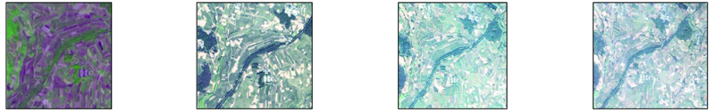
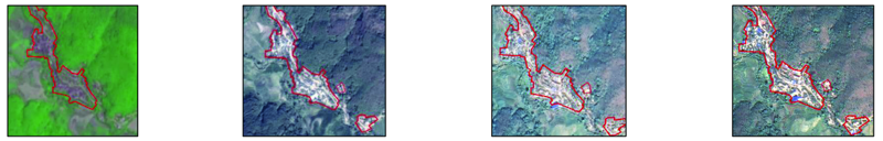
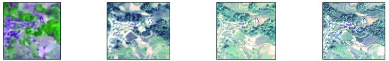
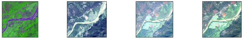
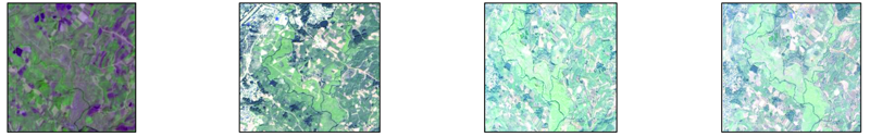
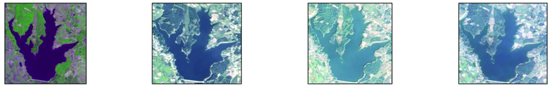
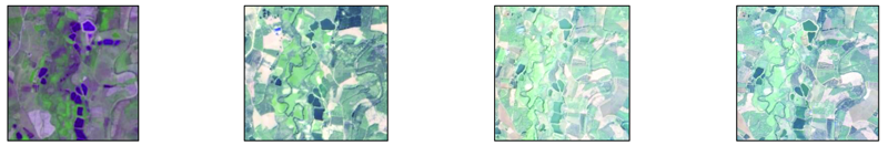
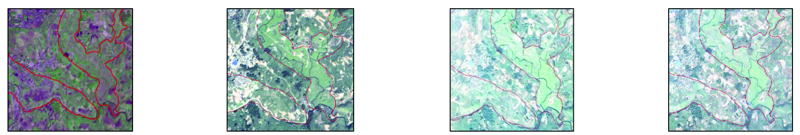
Abstract With the substantial improvement in spatial resolution, spectral resolution, temporal resolution, and data coverage, domestic satellites have been widely used in natural resources supervision and geological surveys. Taking ZY-1 02C, GF-1, GF-2, and ZY-3 satellites as examples, this paper explores and studies their interpretation applications in basic geography, basic geology, land resources, mineral resources development, hydrogeology, engineering geology, and geological disasters. Furthermore, this paper compares, assesses, and summarizes the ability of the domestic satellites in the interpretation of geological survey elements. All these will provide guiding suggestions and scientific references for more extensive and in-depth applications of domestic satellites.
|
| Keywords
domestic satellite
geological remote sensing
interpretation ability
|
|
|
|
Issue Date: 24 September 2021
|
|
|
| [1] |
自然资源部科技发展司. 自然资源部卫星遥感应用报告(2019年)[R]. 北京:自然资源部, 2020.
|
| [1] |
Department of science and technology development,Ministry of Natural Resources of the People's Republic of China. Report on satellite remote sensing application of the Ministry of Natural Resources (2019)[R]. Beijing:Ministry of Natural Resources of the People’s Republic of China, 2020.
|
| [2] |
王润生, 熊盛青, 聂洪峰, 等. 遥感地质勘查技术与应用研究[J]. 地质学报, 2011, 85(11):1699-1743.
|
| [2] |
Wang R S, Xiong S Q, Nie H F, et al. Remote sensing geology and its application ingeological exploration[J]. Acta Geologica Sinica, 2011, 85(11):1699-1743.
|
| [3] |
郑雄伟, 杨金中, 陈玲, 等. 国土资源卫星地质矿产应用成效[J]. 国土资源遥感, 2017, 29(s1):1-7.doi: 10.6046/gtzyyg.2017.s1.01.
doi: 10.6046/gtzyyg.2017.s1.01
|
| [3] |
Zheng X W, Yang J Z, Chen L, et al. A review on the effects of applying land and resources satellites to geology and mineral resources[J]. Remote Sensing for Land and Resources, 2017, 29(s1):1-7.doi: 10.6046/gtzyyg.2017.s1.01.
doi: 10.6046/gtzyyg.2017.s1.01
|
| [4] |
张焜, 马世斌, 李宗仁, 等. 高分一号卫星数据遥感地质解译[J]. 遥感信息, 2017(1):115-123.
|
| [4] |
Zhang K, Ma S B, Li Z R, et al. Geological interpretation of GF-1 satellite inagery[J]. Remote Sensing Information, 2017(1):115-123.
|
| [5] |
陈玲, 梁树能, 周艳, 等. 国产高分卫星数据在高海拔地区地质调查中的应用潜力分析[J]. 国土资源遥感, 2015, 27(1):140-145.doi: 10.6046/gtzyyg.2015.01.22.
doi: 10.6046/gtzyyg.2015.01.22
|
| [5] |
Chen L, Liang S N, Zhou Y, et al. Potential of applying domestic high-resolution remote sensing data to geological survey in high altitudes[J]. Remote Sensing for Land and Resources, 2015, 27(1):140-145.doi: 10.6046/gtzyyg.2015.01.22.
doi: 10.6046/gtzyyg.2015.01.22
|
| [6] |
何凯涛, 甘甫平, 王永江. 高空间分辨率卫星遥感地质微构造及蚀变信息识别研究[J]. 国土资源遥感, 2009(1):97-99.doi: 10.6046/gtzyyg.2009.01.22.
doi: 10.6046/gtzyyg.2009.01.22
|
| [6] |
He K T, Gan F P, Wang Y J. The ectraction of geological micro-structure and altered rock information with high-resolution satellite images in a small range[J]. Remote Sensing for Land and Resources, 2009(1):97-99.doi: 10.6046/gtzyyg.2009.01.22.
doi: 10.6046/gtzyyg.2009.01.22
|
| [7] |
贺奋琴. 基于RS和GIS的水土流失因子提取与分析——以攀枝花市为例[D]. 成都:成都理工大学, 2004.
|
| [7] |
He F Q. Analysis and Extraction of soil and water loss factors based on RS and GIS——the case of Panzhihua City[D]. Chengdu:Chengdu University of Technology, 2004.
|
| [8] |
荆凤, 陈建平. 矿化蚀变信息的遥感提取方法综述[J]. 遥感信息, 2005(2):62-65.
|
| [8] |
Jing F, Chen J P. The review of the alteration information extraction with remote sensing[J]. Remote Sensing Information, 2005(2):62-65.
|
| [9] |
张远飞, 吴健生. 基于遥感图像提取矿化蚀变信息[J]. 矿产勘查, 1999(6):604-606.
|
| [9] |
Zhang Y F, Wu J S. Extraction of mineralization and alteration information from remote sensing images[J]. Mineral Exploration, 1999(6):604-606.
|
| [10] |
沈利霞, 刘丽萍, 苏新旭, 等. 不同植被覆盖率地区遥感矿化蚀变提取研究[J]. 现代地质, 2008, 22(2):293-298.
|
| [10] |
Shen L X, Liu L P, Su X X, et al. Study on identification of altered wall-rock in areas of different vegetation coverages based on remote sensing[J]. Geoscience, 2008, 22(2):293-298.
|
| [11] |
郑纬. 不同自然景观区的矿化蚀变信息检测与提取应用研究[D]. 长沙:中南大学, 2011.
|
| [11] |
Zheng W. Application Research on detection and extraction of mineralization and alteration information in different natural landscape areas[D]. Changsha:Central South University, 2011.
|
| [12] |
郭志娟, 孔牧, 张华, 等. 适合地球化学勘查的景观划分研究[J]. 物探与化探, 2015, 39(1):12-15.
|
| [12] |
Guo Z J, Kong M, Zhang H, et al. Landscape division suitable for geochemical exploration[J]. Geophysical and Geochemical Exploration, 2015, 39(1):12-15.
|
| [13] |
孙家抦. 遥感原理与应用(第二版)[M]. 武汉: 武汉大学出版社, 2009.
|
| [13] |
Sun J B. Remote sensing theories and application (Second Edition)[M]. Wuhan: Wuhan University Press. 2009.
|
| [14] |
贾永红. 数字图像处理(第二版)[M]. 武汉: 武汉大学出版社, 2010.
|
| [14] |
Jia Y H. Digital image processing (Second Edition)[M]. Wuhan: Wuhan University Press, 2010.
|
| [15] |
覃征, 鲍复民, 李爱国, 等. 数字图像融合[M]. 西安: 西安交通大学出版社, 2004.
|
| [15] |
Qin Z, Bao F M, Li A G, et al. Digital image fusion [M]. Xi’an: Xi’an Jiaotong University Press, 2004.
|
| [16] |
齐信, 邵长生, 陈州丰, 等. 多源遥感数据在断裂构造解译中的应用[J]. 大地测量与地球动力学, 2012(32):90-93.
|
| [16] |
Qi X, Shao C S, Chen Z F, et al. Application of multi-source remote sensing data in fault structure interpretation[J]. Journal of Geodesy and Geodynamics, 2012(32):90-93.
|
| [17] |
陈曦, 刘严松. 遥感解译在钒钛磁铁找矿过程中的应用——以攀枝花地区为例[J]. 矿物学报, 2013(s2):745-746.
|
| [17] |
Chen X, Liu Y S. Application of remote sensing interpretation in vanadium titanium magnetite prospecting:The case of Panzhihua area[J]. Acta Mineralogica Sinica, 2013(s2):745-746.
|
| [18] |
陈建平. 断裂构造解译质量的评价[J]. 遥感信息, 1988(3):14-16.
|
| [18] |
Chen J P. Evaluation of interpretation quality of fault structures[J]. Remote Sensing Information, 1988(3):14-16.
|
| [19] |
王丽丽. 攀枝花市土地利用/覆被变化监测与时空演变分析[D]. 成都:成都理工大学, 2010.
|
| [19] |
Wang L L. Land use/cover change monitoring and spatial-temporal evolution analysis in Panzhihua City[D]. Chengdu:Chengdu University of Technology, 2010.
|
| [20] |
聂洪峰, 袁崇桓, 刁淑娟, 等. 遥感技术在攀枝花地区土壤侵蚀调查中的应用研究[J]. 国土资源遥感, 1996(3):15-21.doi: 10.6046/gtzyyg.1996.03.03.
doi: 10.6046/gtzyyg.1996.03.03
|
| [20] |
Nie H F, Yuan C H, Diao S J, et al. The application of remote sensing technique in the survey of soil erosion in Panzhihua area[J]. Remote Sensing for Land and Resources, 1996(3):15-21.doi: 10.6046/gtzyyg.1996.03.03.
doi: 10.6046/gtzyyg.1996.03.03
|
| [21] |
黄洁 .邵怀勇 .杨显华, 等. 四川省矿山开发遥感监测方式与实践[M]. 北京: 测绘出版社, 2013.
|
| [21] |
Huang J, Shao H Y, Yang X H, et al. Methods and practice on remote sensing monitoring of mine development in Sichuan Province[M]. Beijing: Surveying and Mapping Press, 2013.
|
| [22] |
李成尊, 聂洪峰, 汪劲, 等. 矿山地质灾害特征遥感研究[J]. 国土资源遥感, 2005(1):45-48.doi: 10.6046/gtzyyg.2005.01.11.
doi: 10.6046/gtzyyg.2005.01.11
|
| [22] |
Li C Z, Nie H F, Wang J, et al. A remote sensing study of characteristics of geological disasters in a mine[J]. Remote Sensing for Land and Resources, 2005(1):45-48.doi: 10.6046/gtzyyg.2005.01.11.
doi: 10.6046/gtzyyg.2005.01.11
|
| [23] |
李聪. 遥感技术在水文地质勘查中的应用[J]. 水利信息化, 2002(4):35-37.
|
| [23] |
Li C. Application of remote sensing technology in hydrogeological exploration[J]. Water Conservancy Informatization, 2002(4):35-37.
|
| [24] |
童立强, 安国英, 刘春玲, 等. 利用高分辨率遥感数据在水文地质调查中的应用[C]. 深圳:区域遥感应用国际论坛, 2008.
|
| [24] |
Tong L Q, An G Y, Liu C L, et al. Application of high resolution remote sensing data in hydrogeological survey[C]. Shenzhen:International Forum on Regional Remote Sensing Applications, 2008.
|
| [25] |
郭庆十. 遥感技术在区域水文地质调查中应用研究[C]. 南京:中国遥感应用协会暨区域遥感发展与产业高层论坛, 2010:4-6.
|
| [25] |
Guo Q S. The application study of remote sensing technology in field hydrogeology survey[C]. Nanjing:China Association of Remote Sensing Applications and Regional High Level Forum on Remote Sensing Development and Industry, 2010:4-6.
|
| [26] |
潘建永. 遥感技术在1:5万水文地质调查中的应用初探[J]. 河北遥感, 2015(3):15-16.
|
| [26] |
Pan J Y. Preliminary study on the application of remote sensing technology in 1:50000 hydrogeological survey[J]. Hebei Remote Sensing, 2015(3):15-16.
|
| [27] |
尹显科, 黄洁, 刘智. 四川省红层丘陵区地下水遥感综合调查方法和成果[J]. 四川地质学报, 2005, 25(1):35-40.
|
| [27] |
Yin X K, Huang J, Liu Z. Methods and results of remote sensing geological survey for underground water in red beds hills,Sichuan[J]. Acta Geologica Sichuan, 2005, 25(1):35-40.
|
| [28] |
卓宝熙. 工程地质遥感图像典型图谱[M]. 北京: 科学出版社, 1999.
|
| [28] |
Zhuo B X. Typical atlas of remote sensing image of geology engineering[M]. Beijing: Science Press, 1999.
|
| [29] |
卓宝熙. 工程地质遥感判释与应用[M]. 北京: 中国铁道出版社, 2011.
|
| [29] |
Zhuo B X. Remote sensing interpretation and application of geology engineering[M]. Beijing: China Railway Press, 2011.
|
| [30] |
冯东霞, 余德清, 龙解冰, 等. 地质灾害遥感调查的应用前景[J]. 国土资源导刊, 2002, 21(4):314-318.
|
| [30] |
Feng D X, Yu D Q, Long J B, et al. Application prospect of remote sensing survey of geological disasters[J]. Land and Resources Guide, 2002, 21(4):314-318.
|
| [31] |
鲍巨才, 张秀敏. 常见地质灾害的遥感图像解译标志[J]. 科技信息, 2011(10):798-799.
|
| [31] |
Bao J C, Zhang X M. Remote sensing image interpretation signs of common geological disasters[J]. Science and Technology Information, 2011(10):798-799.
|
| [32] |
倪恒, 刘翔宇. 高山峡谷地区的高精度地质灾害遥感解译方法研究[J]. 南方能源建设, 2016, 3(2):146-151.
|
| [32] |
Ni H, Liu X Y. Study on the method of high-precision geological hazard remote sensing interpretation of reservoir in the mountain and ravine region[J]. Southern Energy Construction, 2016, 3(2):146-151.
|
| [33] |
刁淑娟, 刘春玲, 张涛 等. 基于SVM的湖泊咸度等级遥感信息提取方法——以内蒙古巴丹吉林沙漠为例[J]. 国土资源遥感, 2016, 28(4):114-118.doi: 10.6046/gtzyyg.2016.04.18.
doi: 10.6046/gtzyyg.2016.04.18
|
| [33] |
Diao S J, Liu C L, Zhang T, et al. Extraction of remote sensing information for lake salinity level based on SVM:A case from Badain Jaran desert in Inner Mongolia[J]. Remote Sensing for Land and Resources, 2016, 28(4):114-118.doi: 10.6046/gtzyyg.2016.04.18.
doi: 10.6046/gtzyyg.2016.04.18
|
|
Viewed |
|
|
|
Full text
|
|
|
|
|
Abstract
|
|
|
|
|
Cited |
|
|
|
|
| |
Shared |
|
|
|
|
| |
Discussed |
|
|
|
|
 2021,
Vol. 33
2021,
Vol. 33