|
|
 |
|

|
|
|
Prediction of land subsidence along Tianjin-Baoding high-speed railway using WT-RF method |
ZHOU Chaofan1,2,3,4( ), GONG Huili1,2,3,4(), CHEN Beibei1,2,3,4, LEI Kunchao5, SHI Liyuan1,2,4, ZHAO Yu1,2,4 ), GONG Huili1,2,3,4(), CHEN Beibei1,2,3,4, LEI Kunchao5, SHI Liyuan1,2,4, ZHAO Yu1,2,4 |
1. Beijing Laboratory of Water Resources Security, Capital Normal University, Beijing 100048, China
2. Key Laboratory of Mechanism, Prevention and Mitigation of Land Subsidence, MOE, Capital Normal University, Beijing 100048, China
3. Key Laboratory of 3D Information Acquisition and Application, MOE, Capital Normal University, Beijing 100048, China
4. School of Resources Environment and Tourism, Capital Normal University, Beijing 100048, China
5. Beijing Institute of Hydrogeology and Engineering Geology, Beijing 100195, China |
|
|
|
|
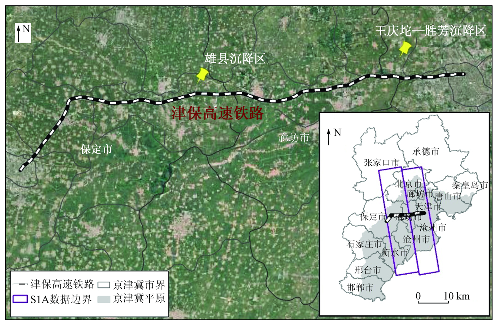
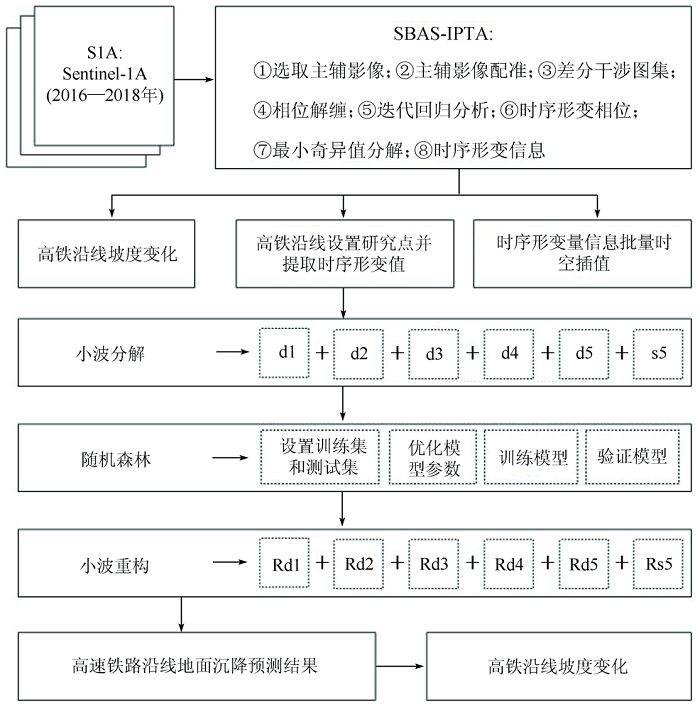
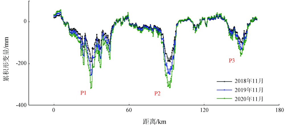
Abstract Land subsidence is an environmental geological phenomenon caused by many factors, and it can reduce the smoothness of high-speed railways and thus affects the safe operation of high-speed railways. Traditional rardom forest models do not take account of the internal complexity of time series data in the prediction of time series data. Therefore, this paper constructs a wavelet transform-random forest (WT-RF) prediction model, predicts the land subsidence along the Tianjin-Baoding high-speed railway using the model, and assesses the impacts of land subsidence on the changes in the slope of the high-speed railway. The results are as follows: ① From 2016 to 2018, the change range of the slope of the Tianjin-Baoding high-speed railway was 0~0.16‰ due to the cumulative land subsidence. ② The WT-RF model showed high prediction accuracy of the land subsidence. ③ From 2018 to 2020, the land subsidence still showed an increasing trend, although the change range of the slope along the Tianjin-Baoding high-speed railway was 0~0.2 ‰. It can be concluded that the land subsidence has an impact on the changes in the slope of the Tianjin-Baoding high-speed railway. Therefore, it is necessary to control the land subsidence to ensure the safe operation of the high-speed railway.
|
| Keywords
land subsidence
Tianjin-Baoding high-speed railway
wavelet transform
rardom forest
|
|
|
|
Corresponding Authors:
GONG Huili
E-mail: chaofan0322@126.com;gonghl@cnu.edu.cn
|
|
Issue Date: 23 December 2021
|
|
|
| [1] |
Chen B B, Gong H L, Chen Y, et al. Land subsidence and its relation with groundwater aquifers in Beijing Plain of China[J]. Science of the Total Environment, 2020,735:139111.
doi: 10.1016/j.scitotenv.2020.139111
url: https://linkinghub.elsevier.com/retrieve/pii/S0048969720326280
|
| [2] |
宫辉力, 李小娟, 潘云, 等. 京津冀地下水消耗与区域地面沉降演化规律[J]. 中国科学基金, 2017,31(1):72-77.
|
| [2] |
Gong H L, Li X J, Pan Y, et al. Groundwater depletion and regional land subsidence of the Beijing-Tianjin-Hebei area[J]. Bulletin of National Natural Science Foundation of China, 2017,31(1):72-77.
|
| [3] |
Guo H, Zhang Z, Cheng G, et al. Groundwater-derived land subsidence in the North China Plain[J]. Environmental Earth Science, 2015,74(2):1415-1427.
doi: 10.1007/s12665-015-4131-2
url: http://link.springer.com/10.1007/s12665-015-4131-2
|
| [4] |
谢海澜, 夏雨波, 孟庆华, 等. 地质环境承载能力评价中关于地面沉降的评估研究[J]. 地质调查与研究, 2019(2):104-108.
|
| [4] |
Xie H L, Xia Y B, Meng Q H, et al. Study on land subsidence assessment in evaluation of carrying capacity of geological environment[J]. Geological Survey and Research, 2019(2):104-108.
|
| [5] |
Gupta S, Stanus Y, Lombaert G, et al. Influence of tunnel and soil parameters on vibrations from underground railways[J]. Journal of Sound and Vibration, 2009,327(1-2):70-91.
doi: 10.1016/j.jsv.2009.05.029
url: https://linkinghub.elsevier.com/retrieve/pii/S0022460X09004817
|
| [6] |
张学东, 葛大庆, 肖斌, 等. 多轨道集成PS-InSAR监测高速公路沿线地面沉降研究——以京沪高速公路(北京—河北)为例[J]. 测绘通报, 2014(10):67-69.
|
| [6] |
Zhang X D, Ge D Q, Xiao B, et al. Study on multi-track integration PS-InSAR monitoring the land subsidence along the highway:Taking JingHu highway (Beijing-Hebei) as an example[J]. Bulletin of Surveying and Mapping, 2014(10):67-69.
|
| [7] |
Ge L, Li X, Chang H C, et al. Impact of ground subsidence on the Beijing-Tianjin high-speed railway as mapped by Radar interferometry[J]. Annals of GIS, 2010,16(2):91-102.
doi: 10.1080/19475683.2010.492125
url: http://www.tandfonline.com/doi/abs/10.1080/19475683.2010.492125
|
| [8] |
Zhao X X, Chen B B, Gong H L, et al. Land subsidence along the Beijing-Tianjin intercity railway during the period of the South-to-North Water Diversion Project[J]. International Journal of Remote Sensing, 2020,41(12):4447-4469.
doi: 10.1080/01431161.2020.1718238
url: https://www.tandfonline.com/doi/full/10.1080/01431161.2020.1718238
|
| [9] |
詹学启, 张占荣. 郑徐高速铁路郑州段区域地面沉降预测分析[J]. 铁道标准设计, 2014(s1):56-60.
|
| [9] |
Zhan X Q, Zhang Z R. Prediction analysis of regional land subsidence in Zhengzhou section of Zhengxu high-speed railway[J]. Railway Standard Design, 2014(s1):56-60.
|
| [10] |
宋小军. 基于MODFLOW对天津宁河县的地面沉降预测研究[J]. 矿产勘查, 2010,1(6):564-568.
|
| [10] |
Song X J. Research on prediction of land subsidence based on MODFLOW in Tianjin Ninghe County[J]. Mineral Exploration, 2010,1(6):564-568.
|
| [11] |
焉建国, 陈正松, 罗志才, 等. 基于AR模型的上海地区地面沉降预测分析[J]. 大地测量与地球动力学, 2009(5):121-124,128.
|
| [11] |
Yan J G, Chen Z S, Luo Z C, et al. Analysis and prediction of land subsidence in shanghai based on AR model[J]. Journal of Geodesy and Geodynamics, 2009(5):121-124,128.
|
| [12] |
徐爱功, 李娜, 张涛. 时间序列分析在地铁沉降观测中的应用[J]. 测绘科学, 2013,38(5):57-60.
|
| [12] |
Xu A G, Li N, Zhang T. Application of time series analysis in subway settlement observation[J]. Science of Surveying and Mapping, 2013,38(5):57-60.
|
| [13] |
郭家伟, 邵传青, 王洁, 等. 时间序列模型和马尔柯夫模型在地面沉降预测中的集成应用[J]. 城市环境与城市生态, 2008,21(1):44-46.
|
| [13] |
Guo J W, Shao C Q, Wang J, et al. Integrated application of time series model and Markov model in land subsidence prediction[J]. Urban Environment and Urban Ecology, 2008,21(1):44-46.
|
| [14] |
范珊珊, 郭海朋, 朱菊艳, 等. 线性回归模型在北京平原地面沉降预测中的应用[J]. 中国地质灾害与防治学报, 2013,24(1):70-74.
|
| [14] |
Fan S S, Guo H P, Zhu J Y, et al. Application of linear regression model for land subsidence prediction in Beijing Plain[J]. The Chinese Journal of Geological Hazard and Control, 2013,24(1):70-74.
|
| [15] |
李红霞, 赵新华, 迟海燕, 等. 基于改进BP神经网络模型的地面沉降预测及分析[J]. 天津大学学报(自然科学与工程技术版), 2009(1):60-64.
|
| [15] |
Li H X, Zhao X H, Chi H Y, et al. Prediction and analysis of land subsidence based on improved BP neural network model[J]. Journal of Tianjin University(Science and Technology), 2009(1):60-64.
|
| [16] |
刘杰. 天津市高铁沿线地面沉降现状及原因分析[J]. 工程技术研究, 2018(9):8-9.
|
| [16] |
Liu J. Status quo and cause analysis of land subsidence along Tianjin high-speed railway[J]. Engineering and Technology Research, 2018(9):8-9.
|
| [17] |
李雪, 叶思源, 宋凡, 等. 京津冀平原区地下水水位变化主导因素的定量识别研究[J]. 水文, 2018,38(1):21-27,57.
|
| [17] |
Li X, Ye S Y, Song F, et al. Quantitative identification of major factors affecting groundwater change in Beijing-Tianjin-Hebei Plain[J]. Hydrology, 2018,38(1):21-27,57.
|
| [18] |
郭建华. 津保高速白沟引线扩建工程地质灾害危险性评估要点分析[J]. 科技创新导报, 2013(12):21.
|
| [18] |
Guo J H. Analysis on the main points of geological hazard risk assessment of Jinbao expressway Baigou line extension project[J]. Science and Technology Innovation Herald, 2013(12):21.
|
| [19] |
Berardino P, Fornaro G, Lanari R, et al. A new algorithm for surface deformation monitoring based on small baseline differential SAR interferograms[J]. IEEE Transactions on Geoscience and Remote Sensing, 2002,40(11):2375-2383.
doi: 10.1109/TGRS.2002.803792
url: http://ieeexplore.ieee.org/document/1166596/
|
| [20] |
曹群, 陈蓓蓓, 宫辉力, 等. 基于SBAS和IPTA技术的京津冀地区地面沉降监测[J]. 南京大学学报(自然科学), 2019(3):381-391.
|
| [20] |
Cao Q, Chen B B, Gong H L, et al. Monitoring of land subsidence in Beijing-Tianjin-Hebei urban by combination of SBAS and IPTA[J]. Journal of Nanjing University (Natural Science), 2019(3):381-391.
|
| [21] |
铁道第三勘察设计院集团有限公司. 城际铁路设计规范[M]. 北京: 中国铁道出版社, 2015.
|
| [21] |
The Third Railway Survey and Design Institute Group Corporation. Intercity railway design code[M]. Beijing: China Railway Publishing House, 2015.
|
| [22] |
李国和, 许再良, 孙树礼, 等. 华北平原地面沉降对高速铁路的影响及其对策[J]. 铁道工程学报, 2007,24(8):7-12.
|
| [22] |
Li G H, Xu Z L, Sun S L, et al. The influence of surface subsidence on construction of high-speed railway in North China Plain and its countermeasures[J]. Journal of Railway Engineering Society, 2007,24(8):7-12.
|
| [23] |
郑霞, 胡东滨, 李权. 基于小波分解和SVM的大气污染物浓度预测模型研究[J]. 环境科学学报, 2020,40(8):2962-2969.
|
| [23] |
Zheng X, Hu D B, Li Q. Study on prediction model of atmospheric pollutant concentration based on wavelet decomposition and SVM[J]. Acta Scientiae Circumslantiae, 2020,40(8):2962-2969.
|
| [24] |
赵紫龙. 基于小波分解的差分灰色神经网络-AR模型及其在地铁隧道沉降预测中应用研究[J]. 测绘通报, 2020(s1):99-103.
|
| [24] |
Zhao Z L. Research on application of differential grey neural network-AR model based on wavelet decomposition in the settlement prediction of metro tunnel[J]. Bulletin of Surveying and Mapping, 2020(s1):99-103.
|
| [25] |
路晨. 基于随机森林和时间序列分析的财务危机预警算法研究[D]. 重庆:重庆邮电大学, 2019.
|
| [25] |
Lu C. Research on financial crisis early warning algorithm based on random forest and time series analysis[D]. Chongqing:Chongqing University of Posts and Telecommunications, 2019.
|
| [26] |
刘红, 党晓东, 都全胜, 等. 基于随机森林算法的日光温室内气温预测模型研究[J]. 中国农学通报, 2020,36(25):95-100.
|
| [26] |
Liu H, Dang X D, Du Q S, et al. Research on forecast model of temperature in solar greenhouse based on random forest algorithm[J]. Chinese Agricultural Science Bulletin, 2020,36(25):95-100.
|
| [27] |
朱锋, 宫辉力, 李小娟, 等. 基于InSAR和小波变换的不均匀沉降段识别——以京津高铁北京段为例[J]. 地理与地理信息科学, 2014,30(1):23-27.
|
| [27] |
Zhu F, Gong H L, Li X J, et al. Identification of uneven land subsidence segment based on the InSAR and wavelet transformation:A case study of Beijing section of Beijing-Tianjin high-speed railway[J]. Geography and Geo-Information Science, 2014,30(1):23-27.
|
|
Viewed |
|
|
|
Full text
|
|
|
|
|
Abstract
|
|
|
|
|
Cited |
|
|
|
|
| |
Shared |
|
|
|
|
| |
Discussed |
|
|
|
|
 2021,
Vol. 33
2021,
Vol. 33