|
|
 |
|

|
|
|
A change vector analysis in posterior probability space combined with fuzzy C-means clustering and a Bayesian network |
LI Yikun1,2( ), YANG Yang1, YANG Shuwen1,2,3, WANG Zihao1 ), YANG Yang1, YANG Shuwen1,2,3, WANG Zihao1 |
1. Faculty of Geomatics,Lanzhou Jiaotong University, Lanzhou 730070, China
2. National-Local Joint Engineering Research Center of Technologies and Applications for National Geographic State Monitoring, Lanzhou 730070, China
3. Gansu Provincial Engineering Laboratory for National Geographic State Monitoring, Lanzhou 730070, China |
|
|
|
|
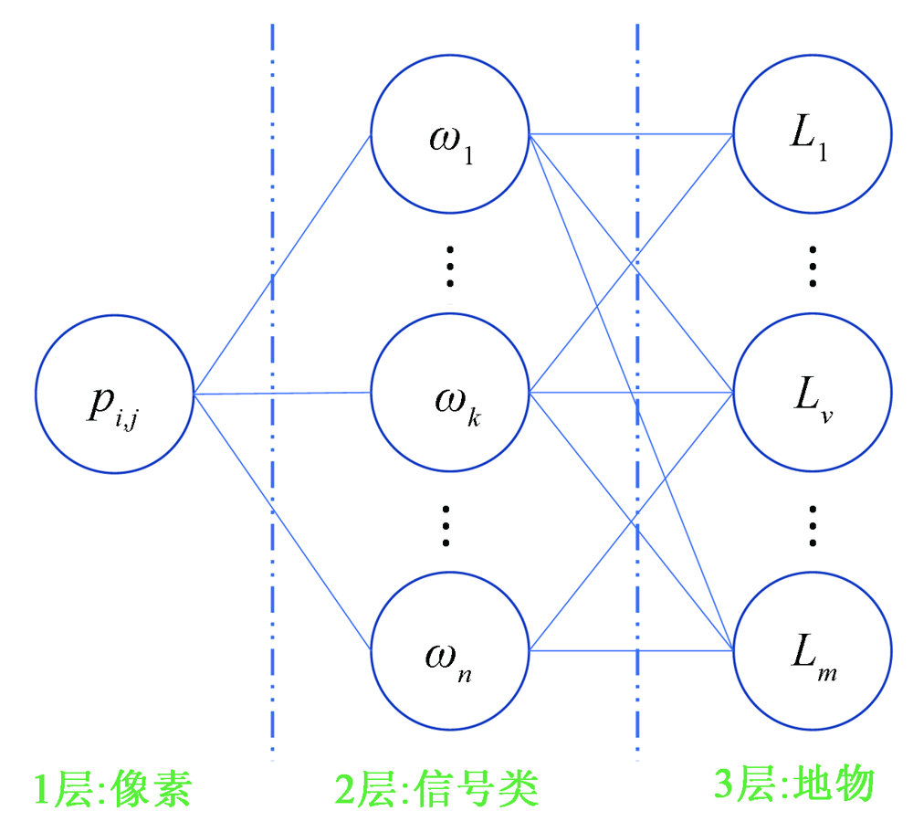
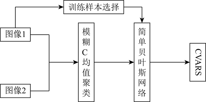
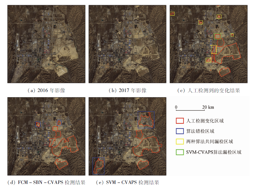
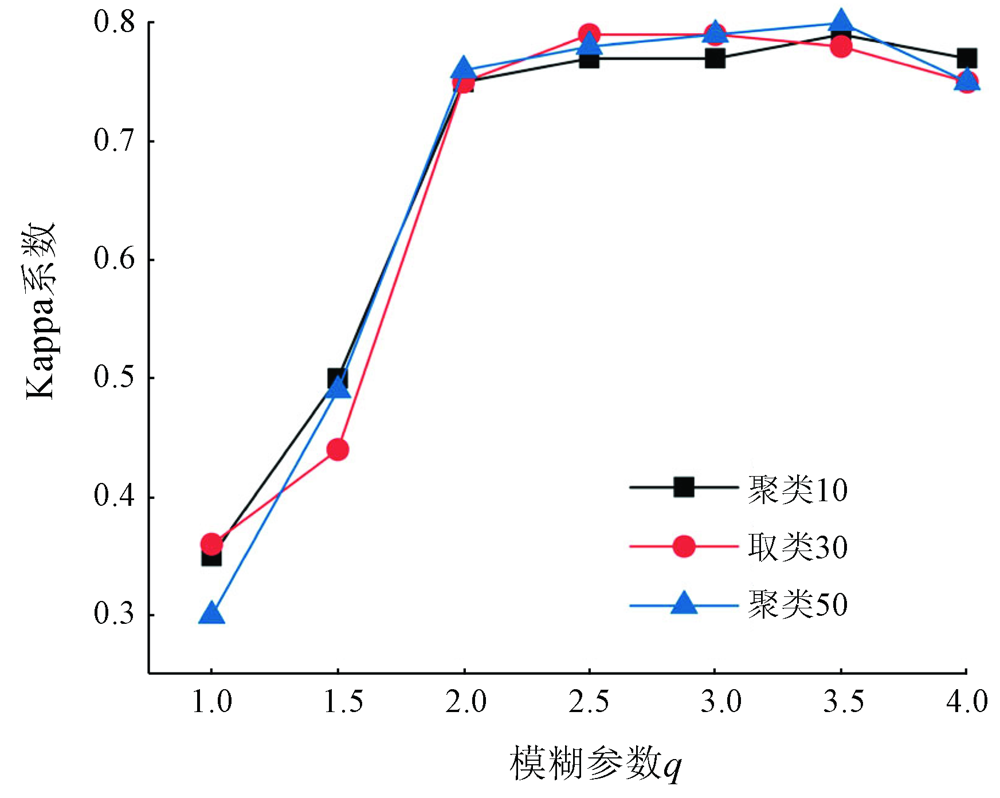
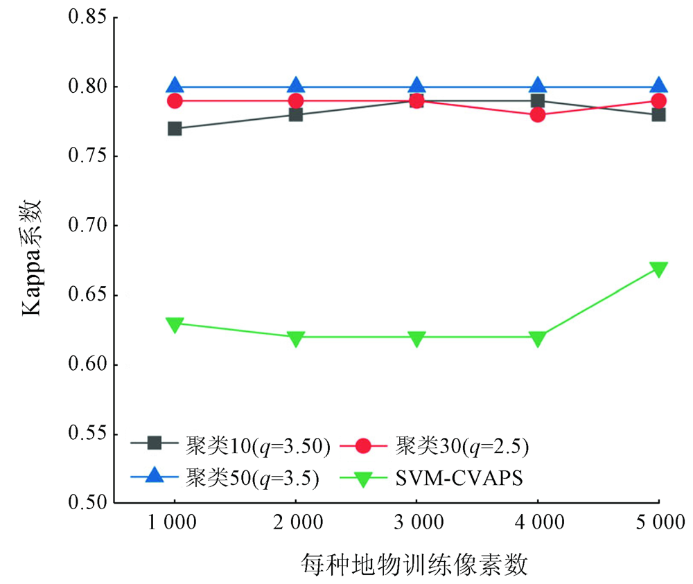
Abstract The change vector analysis in posterior probability space (CVAPS) method has been widely used in the change detection of remote sensing images owing to its many advantages. It uses the support vector machine (SVM) to estimate the posterior probability vector. However, in the classification of low and medium resolution remote sensing images, SVM cannot effectively deal with the problems of the same object with the different spectra, different objects with the same spectrum, and mixed pixels and thus cannot guarantee the accuracy of the final detection results. Therefore, this paper adopts the fuzzy c-means (FCM) clustering for modeling and couples the FCM with a simple Bayesian network (SBN) to solve the problem of mixed pixels and estimate the posterior probability vector, thus achieving a new posterior probability space change vector analysis method. The experimental results indicate that, compared to the SVM-based CVAPS algorithm, the algorithm proposed in this study shows higher overall accuracy, higher Kappa coefficient, more reliable performance that is less affected by the number of training samples, simpler parameter setting, and lower time consumption. Therefore, the algorithm proposed in this paper helps to improve the accuracy and efficiency of the change detection of remote sensing images.
|
| Keywords
remote sensing image
change detection
change vector analysis in posterior probability space
fuzzy C-means clustering
simple Bayesian network
|
|
|
|
Issue Date: 23 December 2021
|
|
|
| [1] |
李德仁. 利用遥感影像进行变化检测[J]. 武汉大学学报(信息科学版), 2003,28(s1):7-12.
|
| [1] |
Li D R. Change detection from remote sensing images[J]. Geomatics and Information Science of Wuhan University, 2003,28(s1):7-12.
|
| [2] |
Coppin P, Jonckheere I, Nackaerts K, et al. Digital change detection methods in ecosystem monitoring:A review[J]. International Journal of Remote Sensing, 2004,25(9):1565-1596.
doi: 10.1080/0143116031000101675
url: https://www.tandfonline.com/doi/full/10.1080/0143116031000101675
|
| [3] |
Tewkesbury A P, Comber A J, Tate N J, et al. A critical synjournal of remotely sensed optical image change detection techniques[J]. Remote Sensing of Environment, 2015,160:1-14.
doi: 10.1016/j.rse.2015.01.006
url: https://linkinghub.elsevier.com/retrieve/pii/S0034425715000152
|
| [4] |
王艳恒, 高连如, 陈正超, 等. 结合深度学习和超像元的高分遥感影像变化检测[J]. 中国图象图形学报, 2020,25(6):1271-1282.
|
| [4] |
Wang Y H, Gao L R, Chen Z C, et al. Deep learning and superpixel-based method for high-resolution remote sensing image change detection[J]. Journal of Image and Graphics, 2020,25(6):1271-1282.
|
| [5] |
Singh A. Digital change detection techniques using remote sensed data[J]. International Journal of Remote Sensing, 1989,10(6):989-1003.
doi: 10.1080/01431168908903939
url: https://www.tandfonline.com/doi/full/10.1080/01431168908903939
|
| [6] |
Yetgin Z. Unsupervised change detection of satellite images using local gradual descent[J]. IEEE Transactions on Geoscience and Remote Sensing, 2012,50(5):1919-1929.
doi: 10.1109/TGRS.2011.2168230
url: http://ieeexplore.ieee.org/document/6059501/
|
| [7] |
郝明, 史文中, 邓喀中. 空间信息准确性增强遥感变化检测[M]. 北京: 测绘出版社, 2017.
|
| [7] |
Hao M, Shi W Z, Deng K Z. Remote sensing change detection based on enhanced spatial information[M]. Beijing: Surveying and Mapping Press, 2017.
|
| [8] |
Chen J, Chen X, Cui X, et al. Change vector analysis in posterior probability space:A new method for land cover change detection[J]. IEEE Geoscience and Remote Sensing Letters, 2011,8(2):317-321.
doi: 10.1109/LGRS.2010.2068537
url: http://ieeexplore.ieee.org/document/5597922/
|
| [9] |
蔡怤晟, 向泽君, 蔡衡, 等. 结合特征选择的CVA多尺度遥感影像变化检测[J]. 测绘通报, 2020(8):101-104.
|
| [9] |
Cai F S, Xiang Z J, Cai H, et al. CVA multi-scale remote sensing image change detection combined with feature selection[J]. Bulletin of Surveying and Mapping, 2020(8):101-104.
|
| [10] |
张春森, 吴蓉蓉, 李国君, 等. 面向对象的高空间分辨率遥感影像箱线图变化检测方法[J]. 国土资源遥感, 2020,32(2):19-25.doi: 10.6046/gtzyyg.2020.02.03.
doi: 10.6046/gtzyyg.2020.02.03
|
| [10] |
Zhang C S, Wu R R, Li G J, et al. High resolution remote sensing image object change detection based on box-plotmethod[J]. Remote Sensing for Land and Resources, 2020,32(2):19-25.doi: 10.6046/gtzyyg.2020.02.03.
doi: 10.6046/gtzyyg.2020.02.03
|
| [11] |
王昶, 张永生, 王旭, 等. 基于深度学习的遥感影像变化检测方法[J]. 浙江大学学报(工学版), 2020,54(11):2138-2148.
|
| [11] |
Wang C, Zhang Y Y, Wang X, et al. Remote sensing image change detection method based on deep neural networks[J]. Journal of Zhejiang University (Engineering Science), 2020,54(11):2138-2148.
|
| [12] |
Daschiel H, Datcu M. Design and evaluation of human-machine communication for image information mining[J]. IEEE Transactions on Multimedia, 2005,7(6):1036-1046.
doi: 10.1109/TMM.2005.858383
url: http://ieeexplore.ieee.org/document/1542081/
|
| [13] |
Ichoku C, Karnieli A. A review of mixture modeling techniques for sub-pixel land cover estimation[J]. Remote Sensing Reviews, 1996,13(3-4):161-186.
|
| [14] |
胡玉玺, 李轶鲲, 杨萍. 基于上下文敏感的贝叶斯网络及方向关系的遥感图像检索[J]. 国土资源遥感, 2017,29(3):70-76.doi: 10.6046/gtzyyg.2017.03.10.
doi: 10.6046/gtzyyg.2017.03.10
|
| [14] |
Hu Y X, Li Y K, Yang P. Retrieving of remote sensing images based on content-sensitive Bayesian networks and direction relations[J]. Remote Sensing for Land and Resources, 2017,29(3):70-76.doi: 10.6046/gtzyyg.2017.03.10.
doi: 10.6046/gtzyyg.2017.03.10
|
| [15] |
Kapur J N, Sahoo P K, Wong A K C. A new method for gray-level picture thresholding using the entropy of the histogram[J]. Computer Vision,Graphics,and Image Processing, 1985,29:273-285.
doi: 10.1016/0734-189X(85)90125-2
url: https://linkinghub.elsevier.com/retrieve/pii/0734189X85901252
|
|
Viewed |
|
|
|
Full text
|
|
|
|
|
Abstract
|
|
|
|
|
Cited |
|
|
|
|
| |
Shared |
|
|
|
|
| |
Discussed |
|
|
|
|
 2021,
Vol. 33
2021,
Vol. 33