|
|
 |
|

|
|
|
Sentinel-2 MSI and Sentinel-1 SAR based information extraction of abandoned land in the western Loess Plateau:A case study of Minhe County in Qinghai |
ZHANG Hao1,2,3( ), GAO Xiaohong1,2,3,4(), SHI Feifei1,2,3, LI Runxiang1,2,3 ), GAO Xiaohong1,2,3,4(), SHI Feifei1,2,3, LI Runxiang1,2,3 |
1. School of Geographical Sciences, Qinghai Normal University, Xining 810008, China
2. MOE Key Laboratory of Tibetan Plateau Land Surface Processes and Ecological, Xining 810008, China
3. Qinghai Province Key Laboratory of Physical Geography and Environmental Process, Xining 810008, China
4. Academy of Plateau Science and Sustainability, Xining 810008, China |
|
|
|
|
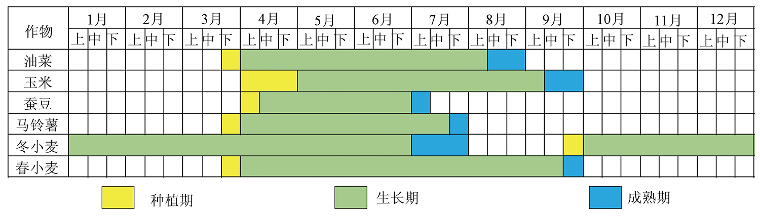
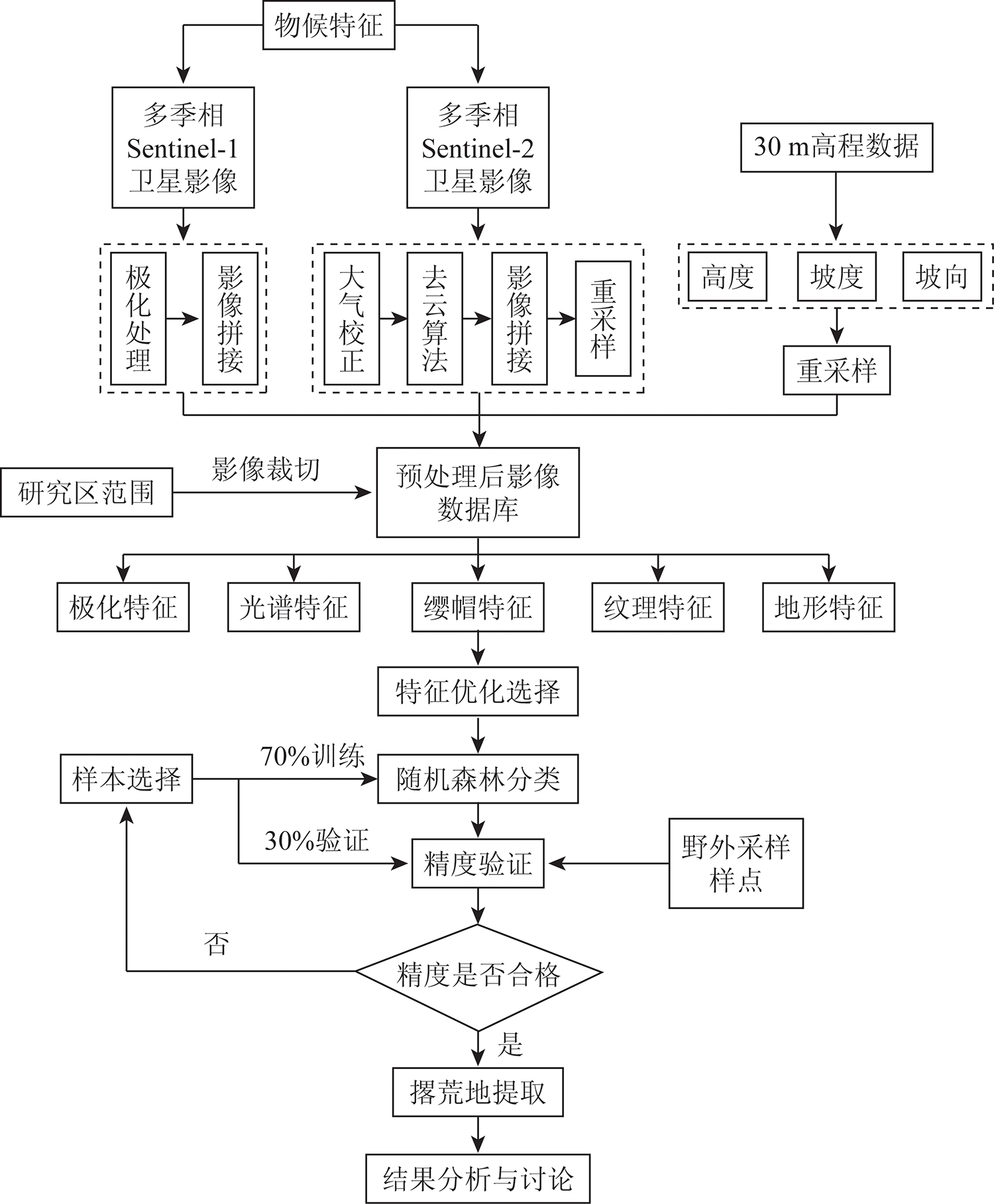
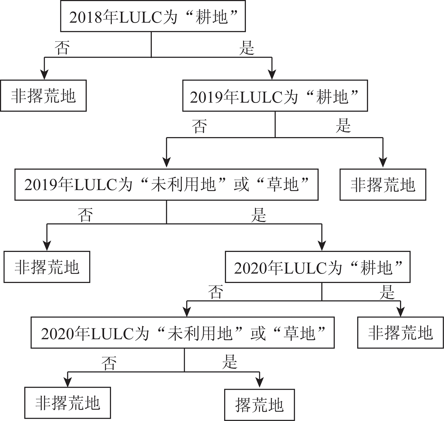
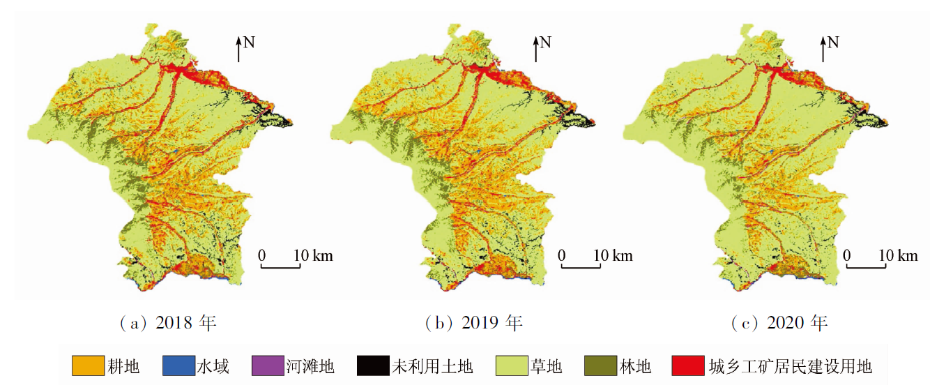
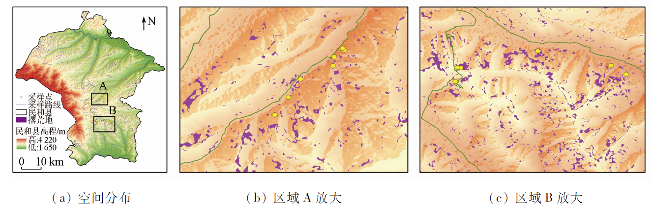
Abstract The eastern agricultural areas of Qinghai are located in the transitional zone from the Loess Plateau to the Qinghai-Tibet Plateau. In this transitional zone, the loess hills feature various landforms, large fluctuations, and fragmentation. With the acceleration of urbanization in recent decades, the shortage of available rural labor force has aggravated land abandonment. Therefore, ascertaining the distribution of abandoned land in the eastern agricultural areas of Qinghai is very crucial to protecting cultivated and ecological land. This study investigated Minhe County in Qinghai Province based on the GEE cloud platform. According to the phenological characteristics of crops, both Sentinel-2 MSI and Sentinel-1 SAR satellite images covering the growth and planting periods of crops were selected as the main data source. With the aid of the DEM and by combining the characteristics of spectra, terrain, polarization, and tasseled cap, this study automatically classified the land cover from 2018 to 2020 in the study area using the random forest method, obtaining the three-year land cover data of the study area. Then, this study built a decision tree based on the determination rules for abandoned land and extracted and verified the abandoned land information using the decision tree. The study results are as follows. The overall classification precision of land cover in 2018, 2019, and 2020 were 86.93%, 87.36%, and 88.54%, respectively. The area of abandoned land in Minhe County in 2020 was 43.17 km2, accounting for 2.28% of the total study area. The abandoned land was mainly distributed in areas with an altitude of 2 200~2 600 m, a slope of 6°~25°, and a shady slope direction. The integration of the polarization characteristics of Sentinel-1 SAR images into Sentinel-2 MSI multi-season images can effectively improve the land cover classification precision and yield accurate information on the abandoned land. This study will provide a reference method and basis for the information extraction of abandoned land in areas with similar terrain.
|
| Keywords
abandoned land
Sentinel-1/2 satellite imagery
multi-season
random forests
western Loess Plateau
Minhe County
|
|
|
|
Issue Date: 27 December 2022
|
|
|
| [1] |
陈欣怡, 郑国全. 国内外耕地撂荒研究进展[J]. 中国人口·资源与环境, 2018, 28(s2):37-41.
|
| [1] |
Chen X Y, Zheng G Q. Research progress on arable land abandonment in China and abroad[J]. China Population,Resources and Environment, 2018, 28(s2):37-41.
|
| [2] |
段亚明, 周洪, 刘秀华, 等. 中国耕地撂荒的研究进展与展望[J]. 江苏农业科学, 2018, 46(13):13-17.
|
| [2] |
Duan Y M, Zhou H, Liu X H, et al. Research progress and prospect of abandonment of China’s cultivated land[J]. Jiangsu Agricultural Sciences, 2018, 46(13):13-17.
|
| [3] |
朱长明, 骆剑承, 沈占锋, 等. 基于地块特征基元与多时相遥感数据的冬小麦播种面积快速提取[J]. 农业工程学报, 2011, 27(9):94-99.
|
| [3] |
Zhu C M, Luo J C, Shen Z F, et al. Winter wheat planting area extraction using multi-temporal remote sensing data based on filed parcel characteristic[J]. Transactions of the Chinese Society of Agricultural Engineering, 2011, 27(9):94-99.
|
| [4] |
陈彦四, 黄春林, 侯金亮, 等. 基于多时相Sentinel-2影像的黑河中游玉米种植面积提取研究[J]. 遥感技术与应用, 2021, 36(2):324-331.
|
| [4] |
Chen Y S, Huang C L, Hou J L, et al. Extraction of maize planting area based on multi-temporal Sentinel-2 imagery in the middle reaches of Heihe River[J]. Remote Sensing Technology and Application, 2021, 36(2):324-331.
|
| [5] |
宋宏利, 雷海梅, 尚明. 基于Sentinel 2A/B时序数据的黑龙港流域主要农作物分类[J]. 江苏农业学报, 2021, 37(1):83-92.
|
| [5] |
Song H L, Lei H M, Shang M. Crop classification based on Sentinel 2A/B time series data in Heilonggang River basin[J]. Jiangsu Journal of Agricultural Sciences, 2021, 37(1):83-92.
|
| [6] |
薛娟, 俞琳锋, 林起楠, 等. 基于Sentinel-1多时相InSAR影像的云南松切梢小蠹危害程度监测[J]. 国土资源遥感, 2018, 30(4):108-114.doi:10.6046/gtzyyg.2018.04.17.
doi: 10.6046/gtzyyg.2018.04.17
|
| [6] |
Xue J, Yu L F, Lin Q N, et al. Using Sentinel-1 multi-temporal InSAR data to monitor the damage degree of shoot beetle in Yunnan pine forests[J]. Remote Sensing for Land and Resources, 2018, 30(4):108-114.doi:10.6046/gtzyyg.2018.04.17.
doi: 10.6046/gtzyyg.2018.04.17
|
| [7] |
肖国峰, 朱秀芳, 侯陈瑶, 等. 撂荒耕地的提取与分析——以山东省庆云县和无棣县为例[J]. 地理学报, 2018, 73(9):1658-1673.
doi: 10.11821/dlxb201809004
|
| [7] |
Xiao G F, Zhu X F, Hou C Y, et al. Extraction and analysis of abandoned farmland:A case study of Qingyun and Wudi counties in Shandong Province[J]. Acta Geographica Sinica, 2018, 73(9):1658-1673.
|
| [8] |
Wu M H, Hu Y M, Wang H M, et al. Remote sensing extraction and feature analysis of abandoned farmland in hilly and mountainous areas:A case study of Xingning,Guangdong[J]. Remote Sensing Applications:Society and Environment, 2020, 20:100403.
doi: 10.1016/j.rsase.2020.100403
url: https://linkinghub.elsevier.com/retrieve/pii/S2352938520301579
|
| [9] |
田颖, 陈卓奇, 惠凤鸣, 等. 欧空局哨兵卫星Sentinel-2A/B数据特征及应用前景分析[J]. 北京师范大学学报(自然科学版), 2019, 55(1):57-65.
|
| [9] |
Tian Y, Chen Z Q, Hui F M, et al. ESAS Sentinel-2A/B satellite:Characteristics and applications[J]. Journal of Beijing Normal University(Natural Science), 2019, 55(1):57-65.
|
| [10] |
杨通, 郭旭东, 邱德鹏, 等. 基于联合变化检测的耕地撂荒信息提取与驱动因素分析[J]. 农业机械学报, 2019, 50(6):201-208.
|
| [10] |
Yang T, Guo X D, Qiu D P, et al. Information extraction and driving factor assessment of farmland abandonment based on joint change detection[J]. Transactions of the Chinese Society for Agricultural Machinery, 2019, 50(6):201-208.
|
| [11] |
He S, Shao H Y, Xian W, et al. Extraction of abandoned land in hilly areas based on the spatio-temporal fusion of multi-source remote sensing images[J]. Remote Sensing, 2021, 13(19):3956.
doi: 10.3390/rs13193956
url: https://www.mdpi.com/2072-4292/13/19/3956
|
| [12] |
王红岩, 汪晓帆, 高亮, 等. 基于季相变化特征的撂荒地遥感提取方法研究[J]. 遥感技术与应用, 2020, 35(3):596-605.
|
| [12] |
Wang H Y, Wang X F, Gao L, et al. Study on extraction method of abandoned farmland based on the seasonal variation characteristics of remotely sensed images[J]. Remote Sensing Technology and Application, 2020, 35(3):596-605.
|
| [13] |
马引弟, 吴静, 李纯斌, 等. 基于Sentinel-2影像数据的耕地撂荒信息提取——以甘肃省天水市八里湾镇为例[J]. 生产力研究, 2020(5):61-64.
|
| [13] |
Ma Y D, Wu J, Li C B, et al. Cultivated land abandonment information extraction based on Sentinel-2 image data:Taking Baliwan Town,Tianshui City,Gansu Province as an example[J]. Productivity Research, 2020(5):61-64.
|
| [14] |
Zeng H W, Wu B F, Wang S, et al. A synthesizing land-cover classification method based on Google Earth Engine:A case study in Nzhelele and Levhuvu Catchments,South Africa[J]. Chinese Geographical Science, 2020, 30(3):13.
|
| [15] |
Gomez C, White J C, Wulder M A. Optical remotely sensed time series data for land cover classification:A review[J]. ISPRS Journal of Photogrammetry and Remote Sensing, 2016, 116:55-72.
doi: 10.1016/j.isprsjprs.2016.03.008
url: https://linkinghub.elsevier.com/retrieve/pii/S0924271616000769
|
| [16] |
马慧娟, 高小红, 谷晓天. 随机森林方法支持的复杂地形区土地利用/土地覆被分类研究[J]. 地球信息科学学报, 2019, 21(3):359-371.
doi: 10.12082/dpxxkx.2019.180346
|
| [16] |
Ma H J, Gao X H, Gu X T. Random forest classification of Landsat8 imagery for the complex terrain area based on the combination of spectral,topographic and texture information[J]. Journal of Geo-Information Science, 2019, 21(3):359-371.
|
| [17] |
张晓羽, 李凤日, 甄贞, 等. 基于随机森林模型的陆地卫星-8遥感影像森林植被分类[J]. 东北林业大学学报, 2016, 44(6):53-57,74.
|
| [17] |
Zhang X Y, Li F R, Zhen Z, et al. Forest vegetation classification of Landsat-8 remote sensing image based on random forests model[J]. Journal of Northeast Forestry University, 2016, 44(6):53-57,74.
|
| [18] |
胡云锋, 商令杰, 张千力, 等. 基于GEE平台的1990年以来北京市土地变化格局及驱动机制分析[J]. 遥感技术与应用, 2018, 33(4):573-583.
|
| [18] |
Hu Y F, Shang L J, Zhang Q L, et al. Land change patterns and driving mechanism Beijing since 1990 based on GEE platform[J]. Remote Sensing Technology and Application, 2018, 33(4):573-583.
|
| [19] |
Souverijns N, Buchhorn M, Horion S, et al. Thirty years of land cover and fraction cover changes over the Sudano-Sahel using Landsat time series[J]. Remote Sensing, 2020, 12(22):3817.
doi: 10.3390/rs12223817
url: https://www.mdpi.com/2072-4292/12/22/3817
|
| [20] |
邹大伟, 李孝玲, 康瑞存, 等. 基于Google Earth Engine的土地覆盖分类方法研究[J]. 测绘与空间地理信息, 2021, 44(s1):100-102,105,109.
|
| [20] |
Zhou D W, Li X L, Kang R C, et al. Research on land cover classification method based on Google Earth Engine[J]. Geomatics and Spatial Information Technology, 2021, 44(s1):100-102,105,109.
|
| [21] |
李文婕, 焦仕军, 李荣. 气候变化对民和县冬小麦的影响分析[J]. 青海农林科技, 2018(4):6-11.
|
| [21] |
Li W J, Jiao S J, Li R. Effects of climate change on winter wheat in Minhe Count[J]. Science and Technology of Qinghai Agriculture and Forestry, 2018(4):6-11.
|
| [22] |
牟晓莉, 李贺, 黄翀, 等. Google Earth Engine在土地覆被遥感信息提取中的研究进展[J]. 国土资源遥感, 2021, 33(2):1-10.doi:10.6046/gtzyyg.2020189.
doi: 10.6046/gtzyyg.2020189
|
| [22] |
Mou X L, Li H, Huang C, et al. Application progress of Google Earth Engine in land use and land cover remote sensing information extraction[J]. Remote Sensing for Land and Resources, 2021, 33(2):1-10.doi:10.6046/gtzyyg.2020189.
doi: 10.6046/gtzyyg.2020189
|
| [23] |
Hu Y, Xu X L, Wu F Y, et al. Estimating forest stock volume in Hunan Province,China,by integrating in situ plot data,Sentinel-2 images,and linear and machine learning regression models[J]. Remote Sensing, 2020, 12(1):186.
doi: 10.3390/rs12010186
url: https://www.mdpi.com/2072-4292/12/1/186
|
| [24] |
Ion S, Alberto G M, Leire S P, et al. Assessment of atmospheric correction methods for Sentinel-2 images in Mediterranean landscapes[J]. International Journal of Applied Earth Observation and Geoinformation, 2018, 73:63-76.
doi: 10.1016/j.jag.2018.05.020
url: https://linkinghub.elsevier.com/retrieve/pii/S0303243418301843
|
| [25] |
方匡南, 吴见彬, 朱建平, 等. 随机森林方法研究综述[J]. 统计与信息论坛, 2011, 26(3):32-38.
|
| [25] |
Fang K N, Wu J B, Zhu J P, et al. A review of technologies on random forests[J]. Journal of Statistics and Information, 2011, 26(3):32-38.
|
| [26] |
吴宏安, 蒋建军, 张海龙, 等. 比值居民地指数在城镇信息提取中的应用[J]. 南京师大学报(自然科学版), 2006, 29(3):118-121.
|
| [26] |
Wu H A, Jiang J J, Zhang H L, et al. Application of ratio resident-area index to retrieve urban residential areas based on Landsat TM data[J]. Journal of Nanjing Normal University(Natural Science Edition), 2006, 29(3):118-121.
|
| [27] |
王正兴, 刘闯, Alfredo H. 植被指数研究进展:从AVHRR-NDVI到MODIS-EVI[J]. 生态学报, 2003(5):979-987.
|
| [27] |
Wang Z X, Liu C, Alfredo H. From AVHRR-NDVI to MODIS-EVI:Advances in vegetation index research[J]. Acta Ecologica Sinica, 2003(5):979-987.
|
| [28] |
徐涵秋. 利用改进的归一化差异水体指数(MNDWI)提取水体信息的研究[J]. 遥感学报, 2005(5):589-595.
|
| [28] |
Xu H Q. A study on information extraction of water body with the modified normalized difference water index(MNDWI)[J]. National Remote Sensing Bulletin, 2005(5):589-595.
|
| [29] |
Belcore E, Piras M, Wozniak E. Specific alpine environment land cover classification methodology:Google Earth Engine processing for Sentinel-2 data[J]. The International Archives of Photogrammetry,Remote Sensing and Spatial Information Sciences, 2020, 43:663-670.
|
| [30] |
高程程, 惠晓威. 基于灰度共生矩阵的纹理特征提取[J]. 计算机系统应用, 2010, 19(6):195-198.
|
| [30] |
Gao C C, Hui X W. GLCM-based texture feature extraction[J]. Computer Systems Applications, 2010, 19(6):195-198.
|
| [31] |
Nedkov R. Orthogonal transformation of segmented images from the satellite Sentinel-2[J]. Comptes Rendus de l’Academie Bulgare des Sciences, 2017, 70(5):687-692.
|
| [32] |
史铁丑, 徐晓红. 重庆市典型县撂荒耕地图斑的提取与验证[J]. 农业工程学报, 2016, 32(24):261-267.
|
| [32] |
Shi T C, Xu X H. Extraction and validation of abandoned farmland parcel in typical counties of Chongqing[J]. Transactions of the Chinese Society of Agricultural Engineering, 2016, 32(24):261-267.
|
| [33] |
王德军, 姜琦刚, 李远华, 等. 基于Sentinel-2A/B时序数据与随机森林算法的农耕区土地利用分类[J]. 国土资源遥感, 2020, 32(4):236-243.doi:10.6046/gtzyyg.2020.04.29.
doi: 10.6046/gtzyyg.2020.04.29
|
| [33] |
Wang D J, Jiang Q G, Li Y H, et al. Land use classification of farming areas based on time series Sentinel-2A/B data and random forest algorithm[J]. Remote Sensing for Land and Resources, 2020, 32(4):236-243.doi:10.6046/gtzyyg.2020.04.29.
doi: 10.6046/gtzyyg.2020.04.29
|
| [34] |
刘智丽, 张启斌, 岳德鹏, 等. 基于Sentinel-2A与NPP-VIIRS夜间灯光数据的城市建成区提取[J]. 国土资源遥感, 2019, 31(4):227-234.doi:10.6046/gtzyyg.2019.04.29.
doi: 10.6046/gtzyyg.2019.04.29
|
| [34] |
Liu Z L, Zhang Q B, Yue D P, et al. Extraction of urban built-up areas based on Sentinel-2A and NPP-VIIRS nighttime light data[J]. Remote Sensing for Land and Resources, 2019, 31(4):227-234.doi:10.6046/gtzyyg.2019.04.29.
doi: 10.6046/gtzyyg.2019.04.29
|
| [35] |
王华, 杨乾鹏, 田云杰, 等. 基于多时相Landsat影像的中亚地区植被覆盖遥感监测[J]. 干旱区地理, 2020, 43(4):1023-1032.
|
| [35] |
Wang H, Yang Q P, Tian Y J, et al. Vegetation coverage monitoring in the Central Asian countries using multi-temporal Landsat images[J]. Arid Land Geography, 2020, 43(4):1023-1032.
|
| [36] |
Ghorbanian A, Zaghian S, Asiyabi R M, et al. Mangrove ecosystem mapping using Sentinel-1 and Sentinel-2 satellite images and random forest algorithm in Google Earth Engine[J]. Remote Sensing, 2021, 13(13):2565.
doi: 10.3390/rs13132565
url: https://www.mdpi.com/2072-4292/13/13/2565
|
|
Viewed |
|
|
|
Full text
|
|
|
|
|
Abstract
|
|
|
|
|
Cited |
|
|
|
|
| |
Shared |
|
|
|
|
| |
Discussed |
|
|
|
|
 2022,
Vol. 34
2022,
Vol. 34