|
|
 |
|

|
|
|
Accurate recognition and extraction of karst abandoned land features based on cultivated land parcels and time series NDVI |
WANG Lingyu1( ), CHEN Quan1, WU Yue1, ZHOU Zhongfa1,2(), DAN Yusheng1 ), CHEN Quan1, WU Yue1, ZHOU Zhongfa1,2(), DAN Yusheng1 |
1. School of Karst Science, Guizhou Normal University, Guiyang 550001, China
2. School of Geography and Environmental Sciences, Guizhou Normal University, Guiyang 550001, China |
|
|
|
|
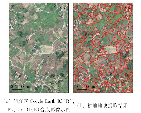
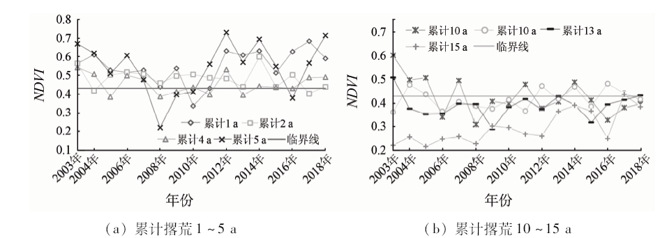
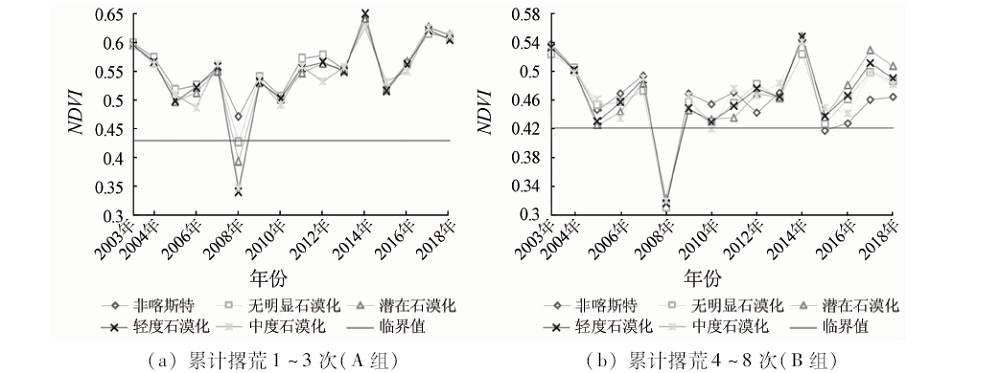
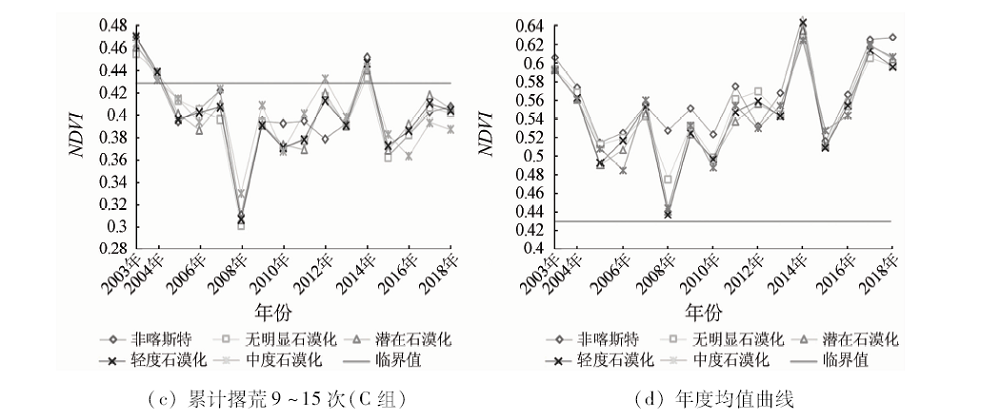
Abstract The abandoned land has been spread all over the world and has become an important research direction for land use. Due to the lack of optical remote sensing images and serious mixed pixels in Karst rocky desertification land, it is difficult to accurately identify and extract the abandoned land. Based on short-term high precision image and long temporal resolution data features, taking Xifeng County in Guizhou Province as an example, using the high precision image accurately, and aided by maximum value composite (MVC) method, the authors calculated Landsat data for 2003—2018 time-series NDVI data, identified characteristics of abandoned land NDVI, and analyzed the relationship between the abandoned land and karst rocky desertification. The results are as follows: ①The combination of land parcels and time series NDVI can accurately identify and extract abandoned land, with an accuracy of 90.7% under the condition of 95.56% of cultivated land extraction. This method has a good application effect in cloudy and rainy mountains areas where optical remote sensing data are lacking and cultivated land is broken. ②The curve shape of the NDVI of the abandoned land is of “V” type, the continuous abandonment of arable land curve shape is of “U” type, and the cumulative NDVI curve shape is of asymmetric “W”, “M” or several combinations. ③The overall level of NDVI in non-karst abandoned lands is higher than that in rocky desertification abandoned lands. The level of rocky desertification is inversely proportional to the overall level of the curve and positively correlated with the degree of curve fluctuation. The number of abandoned lands is inversely proportional to the value of NDVI of the plot and positively correlated with the degree of dispersion of the NDVI curve. The results provide an efficient and feasible method for accurate identification and extraction of uninhabited land in karst cloudy and rainy mountain areas.
|
| Keywords
Karst
rocky desertification of cultivated land
abandoned land
time series analysis
cultivated land parcels
|
|
|
|
Corresponding Authors:
ZHOU Zhongfa
E-mail: wly_yu@163.com;fa6897@163.com
|
|
Issue Date: 09 October 2020
|
|
|
| [1] |
Meyfroidt P, Lambin E F. Global forest transition prospects for an end to deforestation[J]. The Annual Review of Environment and Resources, 2011,36:343-371.
doi: 10.1146/annurev-environ-090710-143732
url: http://www.annualreviews.org/doi/10.1146/annurev-environ-090710-143732
|
| [2] |
陈欣怡, 郑国全. 国内外耕地撂荒研究进展[J]. 中国人口·资源与环境, 2018,28(s2):37-41.
|
| [2] |
Chen X Y, Zheng G Q. Research progress on arable land abandonment in China and abroad[J]. China Population,Resources and Environment, 2018,28(s2):37-41.
|
| [3] |
李升发, 李秀彬. 耕地撂荒研究进展与展望[J]. 地理学报, 2016,71(3):370-389.
|
| [3] |
Li S F, Li X B. Progress and prospect on farmland abandonment[J]. Acta Geographica Sinica, 2016,71(3):370-389.
|
| [4] |
Yusoff N M, Muharam F M, Khairunniza-Bejo S. Towards the use of remote-sensing data for monitoring of abandoned oil palm lands in Malaysia:A semi-automatic approach[J]. International Journal of Remote Sensing, 2017,38(2):432-449.
|
| [5] |
史铁丑, 徐晓红. 重庆市典型县撂荒耕地图斑的提取与验证[J]. 农业工程学报, 2016,32(24):261-267.
|
| [5] |
Shi T C, Xu X H. Extraction and validation of abandoned farmland parcel in typical counties of Chongqing[J]. Transactions of the Chinese Society of Agricultural Engineering, 2016,32(24):261-267.
|
| [6] |
Baumann M, Kuemmerle T, Elbakidze M, et al. Patterns and drivers of post-socialist farmland abandonment in western Ukraine[J]. Land Use Policy, 2011,28(3):552-562.
|
| [7] |
Estel S, Kuemmerle T, Alcántara C, et al. Mapping farmland abandonment and recultivation across Europe using MODIS NDVI time series[J]. Remote Sensing of Environment, 2015,163:312-325.
|
| [8] |
肖国峰, 朱秀芳, 侯陈瑶, 等. 撂荒耕地的提取与分析——以山东省庆云县和无棣县为例[J]. 地理学报, 2018,73(9):1658-1673.
|
| [8] |
Xiao G F, Zhu X F, Hou C Y, et al. Extraction and analysis of abandoned farmland:A case study of Qingyun and Wudi Counties in Shandong Province[J]. Acta Geographica Sinica, 2018,73(9):1658-1673.
|
| [9] |
马尚杰, 裴志远, 王飞, 等. 基于GF-1影像的沿淮地区冬季耕地撂荒遥感调查应用[J]. 农业工程学报, 2019,35(1):227-233.
|
| [9] |
Ma S J, Pei Z Y, Wang F, et al. Application on remote sensing survey of abandoned farmlands in winter along the Huaihe River based on GF-1 image[J]. Transactions of the Chinese Society of Agricultural Engineering, 2019,35(1):227-233.
|
| [10] |
李阳兵, 罗光杰, 黄娟. 茂兰喀斯特自然保护区撂荒地时空演变、机制及其植被恢复[J]. 中国岩溶, 2017,36(4):447-453.
|
| [10] |
Li Y B, Luo G J, Huang J. Spatial-temporal evolution,mechanism and vegetation restoration of abandoned farmland in the Maolan National Nature Reserve[J]. Carsologica Sinica, 2017,36(4):447-453.
|
| [11] |
Wardlow B D, Egbert S L, Kastens J H. Analysis of time-series MODIS 250 m vegetation index data for crop classification in the U.S.central Great Plains[J]. Remote Sensing of Environment, 2007,108(3):290-310.
|
| [12] |
王磊, 王贺, 卢艳丽, 等. NDVI在农作物监测中的研究与应用[J]. 中国农业资源与区划, 2013,34(4):43-50.
|
| [12] |
Wang L, Wang H, Lu Y L, et al. The research and application of NDVI in crop monitoring[J]. Chinese Journal of Agricultural Resources and Regional Planning, 2013,34(4):43-50.
|
| [13] |
郭昱杉, 刘庆生, 刘高焕, 等. 基于MODIS时序NDVI主要农作物种植信息提取研究[J]. 自然资源学报, 2017,32(10):1808-1818.
|
| [13] |
Guo Y S, Liu Q S, Liu G H, et al. Extraction of main crops in Yellow River delta based on MODIS NDVI time series[J]. Journal of Natural Resources, 2017,32(10):1808-1818.
|
| [14] |
许青云, 杨贵军, 龙慧灵, 等. 基于MODIS NDVI多年时序数据的农作物种植识别[J]. 农业工程学报, 2014,30(11):134-144.
|
| [14] |
Xu Q Y, Yang G J, Long H L, et al. Crop information identification based on MODIS NDVI time-series data[J]. Transactions of the Chinese Society of Agricultural Engineering, 2014,30(11):134-144.
|
| [15] |
程维芳. 南方撂荒地遥感调查方法研究[D]. 北京:中国科学院大学, 2011.
|
| [15] |
Cheng W F. Study on remote sensing survey methods of wasteland in southern China[D]. Beijing:University of Chinese Academy of Sciences, 2011.
|
| [16] |
Qiu B, Luo Y, Tang Z, et al. Winter wheat mapping combining variations before and after estimated heading dates[J]. ISPRS Journal of Photogrammetry & Remote Sensing, 2017,123:35-46.
|
| [17] |
朱长明, 骆剑承, 沈占锋, 等. 基于地块特征基元与多时相遥感数据的冬小麦播种面积快速提取[J]. 农业工程学报, 2011,27(9):94-99.
|
| [17] |
Zhu C M, Luo J C, Shen Z F, et al. Winter wheat planting area extraction using multi-temporal remote sensing data based on field parcel characteristic[J]. Transactions of the Chinese Society of Agricultural Engineering, 2011,27(9):94-99.
|
| [18] |
邓刘洋, 沈占锋, 柯映明, 等. 基于地块尺度多时相遥感影像的冬小麦种植面积提取[J]. 农业工程学报, 2018,34(21):157-164.
|
| [18] |
Deng L Y, Shen Z F, Ke Y M, et al. Winter wheat planting area extraction using multi-temporal remote sensing images based on field parcel[J]. Transactions of the Chinese Society of Agricultural Engineering, 2018,34(21):157-164.
|
| [19] |
苏维词. 贵州喀斯特山区的土壤侵蚀性退化及其防治[J].中国岩溶, 2001(3):51-57.
|
| [19] |
Su W C. Soil erosive deterioration and its control in karst mountainous regions of Guizhou Province[J].Carsologica Sinica 2001(3):51-57.
|
| [20] |
李瑞玲, 王世杰, 熊康宁, 等. 贵州省岩溶地区坡度与土地石漠化空间相关分析[J].水土保持通报, 2006(4):82-86.
|
| [20] |
Li R L, Wang S J, Xiong K N, et al. Correlation between rocky desertification and slope degree in Karst area of Guizhou[J].Bulletin of Soil and Water Conservation 2006(4):82-86.
|
| [21] |
贵州省发展和改革委员会, 贵州省科技厅, 贵州师范大学. 贵州省喀斯特石漠化综合防治图集(2006—2050)[M]. 贵阳: 贵州人民出版社, 2007.
|
| [21] |
Guizhou Development and Reform Commission,Guizhou Science and Technology Department,Guizhou Normal University. Atlas of comprehensive control of karst rocky desertification in Guizhou Province(2006—2050)[M]. Guiyang: Guizhou People’s Publishing House, 2007.
|
| [22] |
周忠发, 闫利会, 陈全, 等. 人为干预下喀斯特石漠化演变机制与调控[M]. 北京: 科学出版社, 2016.
|
| [22] |
Zhou Z F, Yan L H, Chen Q, et al. Evolution mechanism and regulation of karst rocky desertification under human intervention[M]. Beijing: Science Press, 2016.
|
| [23] |
赵英时. 遥感应用分析原理与方法[M]. 北京: 科学出版社
|
| [23] |
Zhao Y S. Theory and method of remote sensing application and analysis[M]. Beijing: Science Press, 2003.
|
| [24] |
程维芳, 周艺, 王世新, 等. 基于多光谱遥感的撂荒地识别方法研究[J]. 光谱学与光谱分析, 2011,31(6):1615-1620.
pmid: 21847945
|
| [24] |
Cheng W F, Zhou Y, Wang S X, et al. Study on the method of recognizing abandoned farmlands based on multispectral remote sensing[J]. Spectroscopy and Spectral Analysis, 2011,31(6):1615-1620.
pmid: 21847945
url: https://www.ncbi.nlm.nih.gov/pubmed/21847945
|
| [25] |
王利军, 郭燕, 贺佳, 等. 基于决策树和SVM的Sentinel-2A影像作物提取方法[J]. 农业机械学报, 2018,49(9):146-153.
|
| [25] |
Wang L J, Guo Y, He J, et al. Classification method by fusion of decision tree and SVM based on Sentinel-2A image[J]. Transactions of the Chinese Society for Agricultural Machinery, 2018,49(9):146-153.
|
|
Viewed |
|
|
|
Full text
|
|
|
|
|
Abstract
|
|
|
|
|
Cited |
|
|
|
|
| |
Shared |
|
|
|
|
| |
Discussed |
|
|
|
|
 2020,
Vol. 32
2020,
Vol. 32