|
|
 |
|

|
|
|
Sentinel-1A based flood inundation monitoring in Anhui Province during the plum rain period of 2020 |
HE Binfang1,2( ), YAO Yun1,2, FENG Yan1,2, LIU Huimin1,2, DAI Juan3 ), YAO Yun1,2, FENG Yan1,2, LIU Huimin1,2, DAI Juan3 |
1. Anhui Institute of Meteorological Sciences, Anhui Province Key Laboratory of Atmospheric Sciences and Satellite Remote Sensing, Hefei 230031, China
2. Shouxian National Climatology Observatory, Huaihe River Basin Typical Farmland Ecological Meteorological Field Science Experiment Base of CMA, Huainan 232200, China
3. Anhui Climate Center, Hefei 230031, China |
|
|
|
|
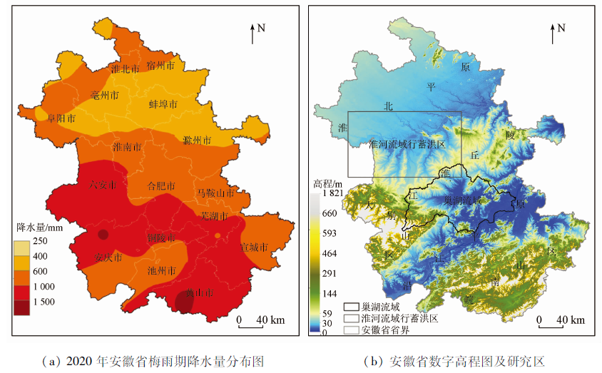
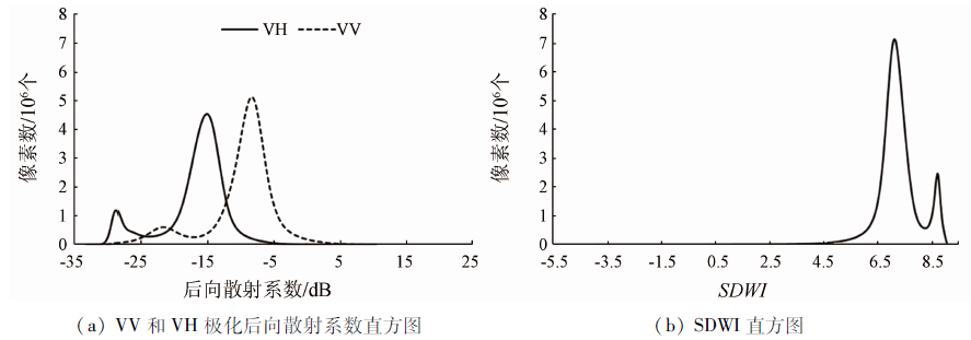
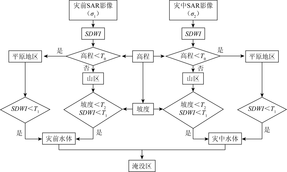
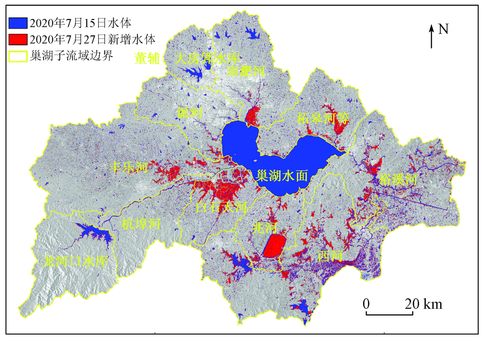
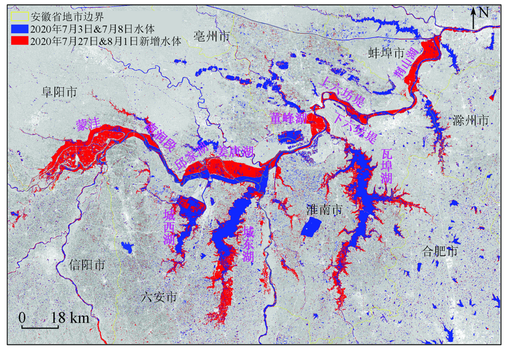
Abstract In 2020, a flood disaster occurred throughout Anhui Province due to the persistent heavy rainfall during the super-long plum rain period. To quickly and accurately extract the flood inundation ranges and provide scientific support for flood prevention and disaster relief, this study selected the pre-disaster and mid-disaster Sentinel-1A/SAR data of the Chaohu Lake and Huaihe River basin in Anhui Province. After rapid data preprocessing, this study extracted information about water bodies in the plains and mountainous areas using the Sentinel-1 dual-polarized water index (SDWI) method and topographic factors. Then, it established a monitoring process for flooded areas. Using this process, this study extracted the flood inundation ranges of the Chaohu Lake and Huaihe River basins on July 27, 2020 using the pre-disaster and mid-disaster synthetic aperture Radar (SAR) data. The results are as follows. The SDWI was superior to the backscattering coefficient in the extraction of information about water bodies. The Chaohu basin had a flood inundation area of 524.8 km2 on July 27, and the Baishitian River subbasin was the most severely inundated, followed by the Xihe River subbasin. In the flood flowing and storage areas of the Huaihe River basin within Anhui Province, the flood inundation area of four cities along the Huaihe River basin decreased in the order of Huainan City, Fuyang City, Lu’an City, and Bengbu City. The results of this study show that the Sentinel-1A-based monitoring process of flood inundation areas established using SDWI and topographic factors has high accuracy, applicability, and timeliness for plains and mountainous areas and is convenient for the timely monitoring of flood disasters in these areas.
|
| Keywords
Sentinel-1A/SAR
flood monitoring
plum rain
Sentinel-1 dual-polarized water index (SDWI)
slope
|
|
|
|
Issue Date: 20 March 2023
|
|
|
| [1] |
王蒙, 殷淑燕. 近52 a长江中下游地区极端降水的时空变化特征[J]. 长江流域资源与环境, 2015, 24(7):1221-1229.
|
| [1] |
Wang M, Yin S Y. Spatio-temporal variations of the extreme precipitation of middle and lower reaches of the Yangtze River in recent 52 years[J]. Resources and Environment in the Yangtze Basin, 2015, 24(7):1221-1229.
|
| [2] |
潘欣, 尹义星, 王小军. 1960—2010年长江流域极端降水的时空演变及未来趋势[J]. 长江流域资源与环境, 2017, 26(3):436-444.
|
| [2] |
Pan X, Yin Y X, Wang X J. Spatio-temporal characteristics and future trend of extreme precipitation in the Yangtze River basin during 1960 to 2010[J]. Resources and Environment in the Yangtze Basin, 2017, 26(3):436-444.
|
| [3] |
佘敦先, 夏军, 张永勇, 等. 近20年来淮河流域极端降水的时空变化及统计特征[J]. 地理学报, 2011, 66(9):1200-1210.
|
| [3] |
She D X, Xia J, Zhang Y Y, et al. The trend analysis and statistical distribution of extreme rainfall events in the Huaihe River basin in the past 50 years[J]. Acta Geographica Sinica, 2011, 66(9):1200-1210.
doi: 10.11821/xb201109005
|
| [4] |
王莉萍, 王维国, 张建忠. 我国主要流域降水过程时空分布特征分析[J]. 自然灾害学报, 2018, 27(2):161-173.
|
| [4] |
Wang L P, Wang W G, Zhang J Z. Analysis on spatial and temporal distribution characteristics of precipitation processes over main river basin in China[J]. Journal of Natural Disasters, 2018, 27(2):161-173.
|
| [5] |
何彬方, 冯妍, 荀尚培, 等. 安徽省50年日照时数的变化特征及影响因素[J]. 自然资源学报, 2009, 24(7):1275-1285.
doi: 10.11849/zrzyxb.2009.07.015
|
| [5] |
He B F, Feng Y, Xun S P, et al. Climatic change of sunshine duration and its influencing factors over Anhui Province during the last 50 years[J]. Journal of Natural Resources, 2009, 24(7):1275-1285.
|
| [6] |
张宏群, 范伟, 荀尚培, 等. 基于MODIS和GIS的洪水识别及淹没区土地利用信息提取[J]. 灾害学, 2010, 25(4):22-26.
|
| [6] |
Zhang H Q, Fan W, Xun S P. Flood identification method based on MODIS and GIS and information extraction of land use of submerged area[J]. Journal of Catastrophology, 2010, 25(4):22-26.
|
| [7] |
张薇, 杨思全, 王磊, 等. 合成孔径雷达数据减灾应用潜力研究综述[J]. 遥感技术与应用, 2012, 27(6):904-911.
|
| [7] |
Zhang W, Yang S Q, Wang L, et al. Review on disaster reduction application potentiality of synthetic aperture Radar[J]. Remote Sensing Technology and Application, 2012, 27(6):904-911.
|
| [8] |
邵佳丽, 郑伟, 刘诚. 卫星遥感洞庭湖主汛期水体时空变化特征及影响因子分析[J]. 长江流域资源与环境, 2015, 24(8):1315-1321.
|
| [8] |
Shao J L, Zheng W, Liu C. Analysis of spatial-temporal variations in the main flood season and their influencing factors of the Dongting Lake based on meteorological satellite data[J]. Resources and Environment in the Yangtze Basin, 2015, 24(8):1315-1321.
|
| [9] |
郭立峰, 殷世平, 许佳琦, 等. 基于FY-3A/MERSI的2013年夏秋间松花江和黑龙江干流洪水遥感监测分析[J]. 自然灾害学报, 2015, 24(5):75-82.
|
| [9] |
Guo L F, Yin S P, Xu J Q, et al. FY-3A/MERSI-based flood remote sensing monitoring and analysis of main stream of Songhua River and Heilong River between summer and autumn in 2013[J]. Journal of Natural Disasters, 2015, 24(5):75-82.
|
| [10] |
王大钊, 王思梦, 黄昌. Sentinel-2和Landsat8影像的四种常用水体指数地表水体提取对比[J]. 国土资源遥感, 2019, 31(3):157-165.doi:10.6046/gtzyyg.2019.03.20.
doi: 10.6046/gtzyyg.2019.03.20
|
| [10] |
Wang D Z, Wang S M, Huang C. Comparison of Seentinel-2 imagery with Landsat8 imagery for surface water extraction using for common water indexes[J]. Remote Sensing for Land and Resources, 2019, 31(3):157-165.doi:10.6046/gtzyyg.2019.03.20
doi: 10.6046/gtzyyg.2019.03.20
|
| [11] |
黄萍, 许小华, 李德龙. 基于Sentinel-1卫星数据快速提取鄱阳湖水体面积[J]. 水资源研究, 2018, 7(5):483-491.
|
| [11] |
Huang P, Xu X H, Li D L. Rapid extraction of water area in Poyang Lake based on Sentinel-1 satellite images[J]. Journal of Water Resources Research, 2018, 7(5):483-491.
doi: 10.12677/JWRR.2018.75054
url: https://www.HansPub.org/journal/doi.aspx?DOI=10.12677/JWRR.2018.75054
|
| [12] |
杨魁, 杨建兵, 江冰茹. Sentinel-1卫星综述[J]. 城市勘测, 2015, 30(2):24-27.
|
| [12] |
Yang K, Yang J B, Jiang B R. Sentinel-1 satellite overview[J]. Urban Geotechnical Investigation & Surveying, 2015, 30(2):24-27.
|
| [13] |
崔斌, 张永红, 闫利, 等. 高分三号SAR影像双阈值变化检测[J]. 遥感学报, 2020, 24(1):1-10.
|
| [13] |
Cui B, Zhang Y H, Yan L, et al. Dual-thresholds change detection in GF-3 SAR images[J]. Journal of Remote Sensing, 2020, 24(1):1-10.
|
| [14] |
崔倩, 毛旭东, 陈德清, 等. 基于高分三号卫星数据的水体自动提取及应用[J]. 中国农业信息, 2019, 31(5):57-65.
|
| [14] |
Cui Q, Mao X D, Chen D Q, et al. Research on automation and operationality in water extraction based on GF-3[J]. China Agricultural Informatics, 2019, 31(5):57-65.
|
| [15] |
吴文会, 王丽欣, 马卓. 基于Sentinel-1B SAR数据的洪水提取和监测[J]. 测绘与空间地理信息, 2019, 42(4):110-118.
|
| [15] |
Wu W H, Wang L X, Ma Z. Flood extraction and monitoring based on Sentinel-1B SAR data[J]. Geomatics & Spatial Information Technology, 2019, 42(4):110-118.
|
| [16] |
汤玲英, 刘雯, 杨东, 等. 基于面向对象方法的Sentinel-1A SAR在洪水监测中的应用[J]. 地球信息科学学报, 2018, 20(3):377-384.
doi: 10.12082/dqxxkx.2018.170599
|
| [16] |
Tang L Y, Liu W, Yang D, et al. Flooding monitoring application based on the object-oriented method and Sentinel-1A SAR data[J]. Journal of Geo-Information Science, 2018, 20(3):377-384.
|
| [17] |
栾玉洁, 郭金运, 高永刚, 等. 基于Sentinel-1B SAR数据的2018年寿光洪水遥感监测及灾害分析[J]. 自然灾害学报, 2021, 30(2):168-175.
|
| [17] |
Luan Y J, Guo J Y, Gao Y G, et al. Remote sensing monitoring of flood and disaster analysis in Shouguang in 2018 from Sentinel-1B SAR data[J]. 2021, 30(2):168-175.
|
| [18] |
Lyu W T, Yu Q Z, Yu W X. Water extraction in SAR images using GLCM and support vector machine[C]// IEEE 10th International Conference on Signal Processing Proceedings.Beijing, 2010:740-743.
|
| [19] |
Gong M G, Li Y, Jiao L C, et al. SAR change detection based on intensity and texture changes[J]. ISPRS Journal of Photogrammetry and Remote Sensing, 2014, 93:123-135.
doi: 10.1016/j.isprsjprs.2014.04.010
url: https://linkinghub.elsevier.com/retrieve/pii/S0924271614001051
|
| [20] |
李景刚, 黄诗峰, 李纪人. ENVISAT卫星先进合成孔径雷达数据水体提取研究——改进的最大类间方差阈值法[J]. 自然灾害学报, 2010, 19(3):139-145.
|
| [20] |
Li J G, Huang S F, Li J R. Research on extraction of water body from ENVISAT ASAR images:A modified Otsu threshold method[J]. Journal of Natural Disasters, 2010, 19(3):139-145.
|
| [21] |
Claire H, Stephen C, Sandro M, et al. Improving the extraction of crisis information in the context of flood,landslide,and fire rapid mapping using SAR and optical remote sensing data[C]// IEEE International Geoscience and Remote Sensing Symposium.Beijing, 2016:171-182.
|
| [22] |
郭欣, 赵银娣. 基于Sentinel-1A SAR的湖南省宁乡市洪水淹没监测[J]. 遥感技术与应用, 2018, 33(4):646-656.
|
| [22] |
Guo X, Zhao Y D. Flood inundation monitoring in Ningxiang of Hunan Province based on Sentinel-1A SAR[J]. Remote Sensing Technology and Application, 2018, 33,(4):646-656.
|
| [23] |
贾诗超, 薛东剑, 李成绕, 等. 基于Sentinel-1数据的水体信息提取方法研究[J]. 人民长江, 2019, 50(2):213-217.
|
| [23] |
Jia S C, Xue D J, Li C R, et al. Study on new method for water area information extraction based on Sentinel-1 data[J]. Yangtze River, 2019, 50(2):213-217.
|
| [24] |
杨泽楠, 黄亮, 王枭轩. 结合DEM的面向对象高分三号SAR影像高原山区水系提取[J]. 昆明理工大学学报(自然科学版), 2019, 44(1):39-46.
|
| [24] |
Yang Z N, Huang L, Wang X X. An object-oriented water extraction for plateau mountain areas in GF-3 SAR image based on DEM[J]. Journal of Kunming University of Science and Technology(Natural Science), 2019, 44(1):39-46.
|
| [25] |
孙亚勇, 黄诗峰, 李纪人, 等. Sentinel-1A SAR数据在缅甸伊洛瓦底江下游区洪水监测中的应用[J]. 遥感技术与应用, 2017, 32(2):282-288.
|
| [25] |
Sun Y Y, Huang S F, Li J R, et al. The downstream flood monitoring application of Myanmar Irrawaddy River based on sentinel-1A SAR[J]. Remote Sensing Technology and Application, 2017, 32(2):282-288.
|
| [26] |
贾良清, 欧阳志云, 赵同谦, 等. 安徽省生态功能区划研究[J]. 生态学报, 2005, 25(2):254-260.
|
| [26] |
Jia L Q, Ouyang Z Y, Zhao T Q, et al. The ecological function regionalization of Anhui Province[J]. Acta Ecologica Sinica, 2005, 25(2):254-260.
|
| [27] |
European Space Agency. Sentinel-1 user handbook[EB/OL].[2018-06-01]. https://sentinels.copernicus.eu/web/sentinel/user-guides/Sentinel-1-SAR.
url: https://sentinels.copernicus.eu/web/sentinel/user-guides/Sentinel-1-SAR
|
| [28] |
European Space Agency. Sentinel-1 SAR user guide[EB/OL].[2018-06-01]. https://sentinel.esa.int/web/sentinel/user-guides/Sentinel-1-SAR.
url: https://sentinel.esa.int/web/sentinel/user-guides/Sentinel-1-SAR
|
| [29] |
European Space Agency. Sentinel-1 SAR technical guide[EB/OL].[2018-06-01]. https://sentinel.esa.int/web/sentinel/technical-guides/Sentinel-1-SAR.
url: https://sentinel.esa.int/web/sentinel/technical-guides/Sentinel-1-SAR
|
| [30] |
Zhang M M, Li Z, Tian B S, et al. The backscattering characteristics of wetland vegetation and water-level changes detection using multi-mode SAR:A case study[J]. International Journal of Applied Earth Observation and Geoinformation, 2016, 45:1-13.
doi: 10.1016/j.jag.2015.10.001
url: https://linkinghub.elsevier.com/retrieve/pii/S0303243415300362
|
| [31] |
王荣喜, 徐维国, 陈祥. 2020年安徽省长江流域防汛抗洪回顾与启示[J]. 人民长江, 2020, 51(12):52-55.
|
| [31] |
Wang R X, Xu W G, Chen X. Review and enlightenment on Yangtze River flood control in Anhui Province in 2020[J]. Yangtze River, 2020, 51(12):52-55.
|
| [32] |
卢程伟, 刘佳明, 徐兴亚. 2020年巢湖流域防洪存在的问题及其对策探讨[J]. 人民长江, 2020, 51(12):155-159.
|
| [32] |
Lu C W, Liu J M, Xu X Y. Discussion on existing problems and countermeasures of flood control in Chaohu Lake basin in 2020[J]. Yangtze River, 2020, 51(12):155-159.
|
| [33] |
唐德可, 王峰, 王宏琦. 基于马尔科夫分割的单极化SAR数据洪涝水体检测方法[J]. 电子与信息学报, 2019, 41(3):619-625.
|
| [33] |
Tang D K, Wang F, Wang H Q. Single-polarization SAR data flood water detection method based on Markov segmentation[J]. Journal of Electronics & Information Technology, 2019, 41(3):619-625.
|
| [34] |
孙亚勇, 李小涛, 杨锋杰, 等. 基于星载SAR数据的山区水体提取方法研究[J]. 中国水利水电科学研究院学报, 2014, 12(3):258-263.
|
| [34] |
Sun Y Y, Li X T, Yang F J, et al. Study on the method of mountain water extraction based on the space-borne SAR images[J]. China Institute of Water Resources and Hydropower Research, 2014, 12(3):258-263.
|
|
Viewed |
|
|
|
Full text
|
|
|
|
|
Abstract
|
|
|
|
|
Cited |
|
|
|
|
| |
Shared |
|
|
|
|
| |
Discussed |
|
|
|
|
 2023,
Vol. 35
2023,
Vol. 35