|
|
 |
|

|
|
|
Analysis of the applicability of three remote sensing spatiotemporal fusion algorithms in flood monitoring |
Chenlie SHI1, Xuhong WANG1,2( ), Meng ZHANG1, Zhuang LIU1, Xinming ZHU3 ), Meng ZHANG1, Zhuang LIU1, Xinming ZHU3 |
1. College of Urban and Environmental Sciences, Northwest University, Xi’an 710127,China
2. Shaanxi Key Laboratory of Earth Surface System and Environmental Carrying Capacity, Northwest University, Xi’an 710127, China
3. College of Resources and Environment, University of Chinese Academy of Sciences, Beijing,100049,China |
|
|
|
|
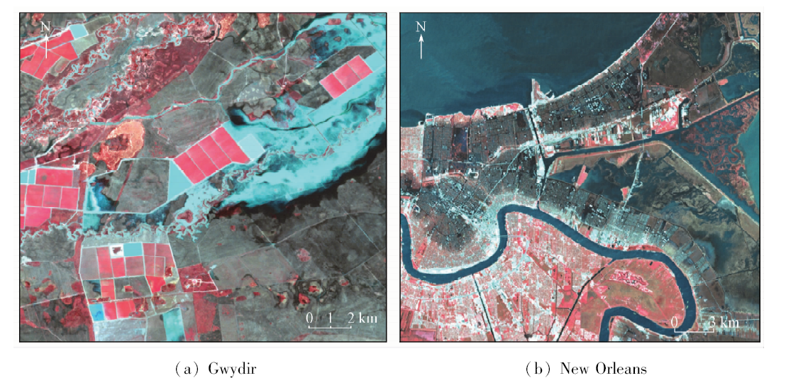
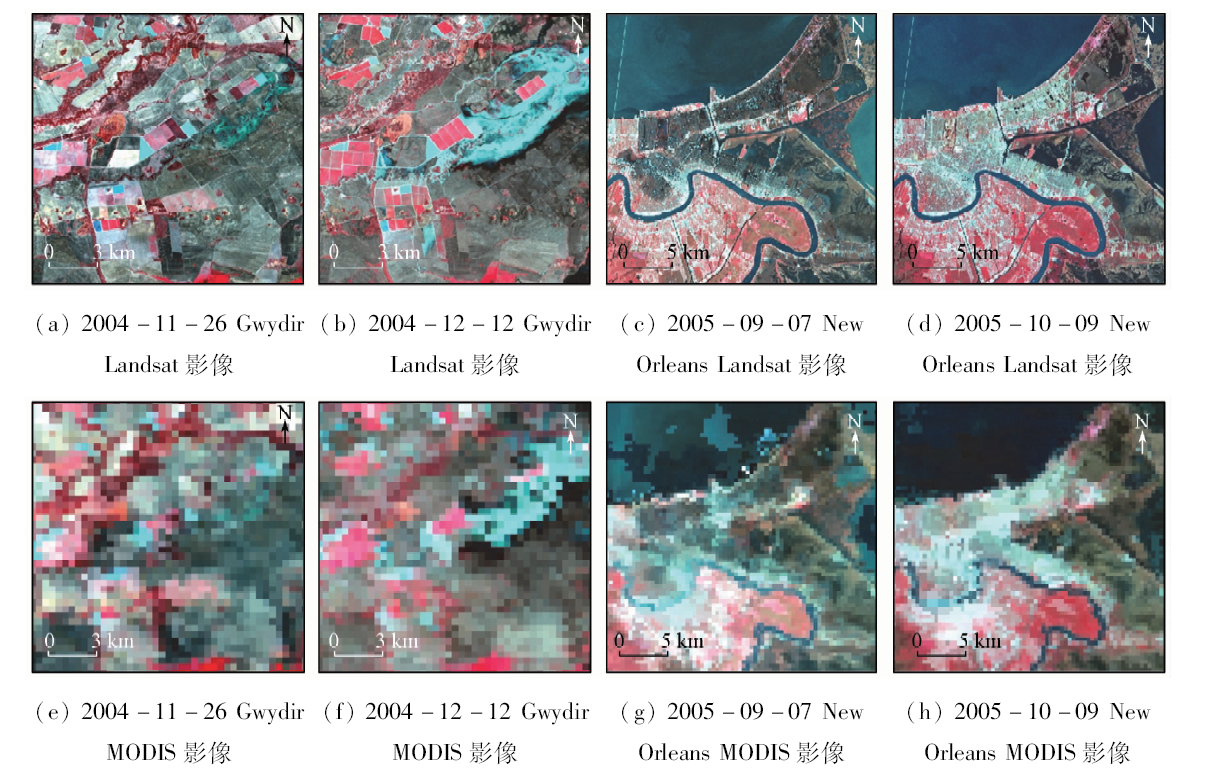
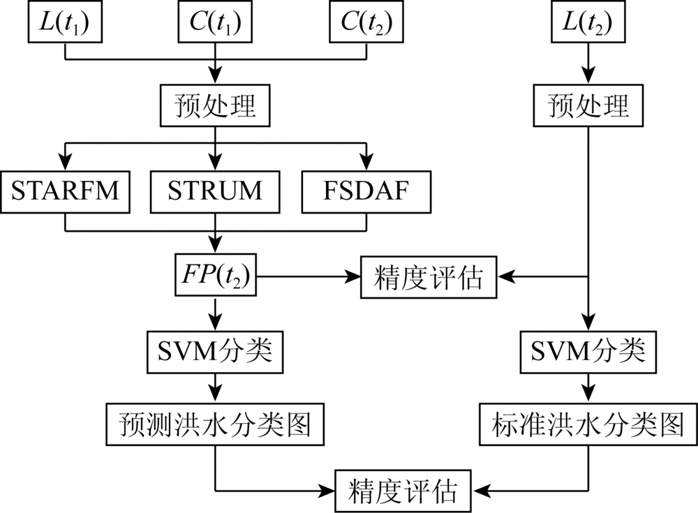
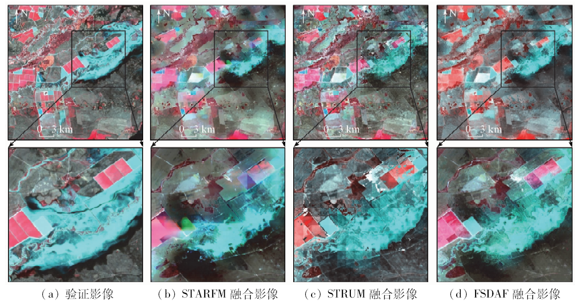
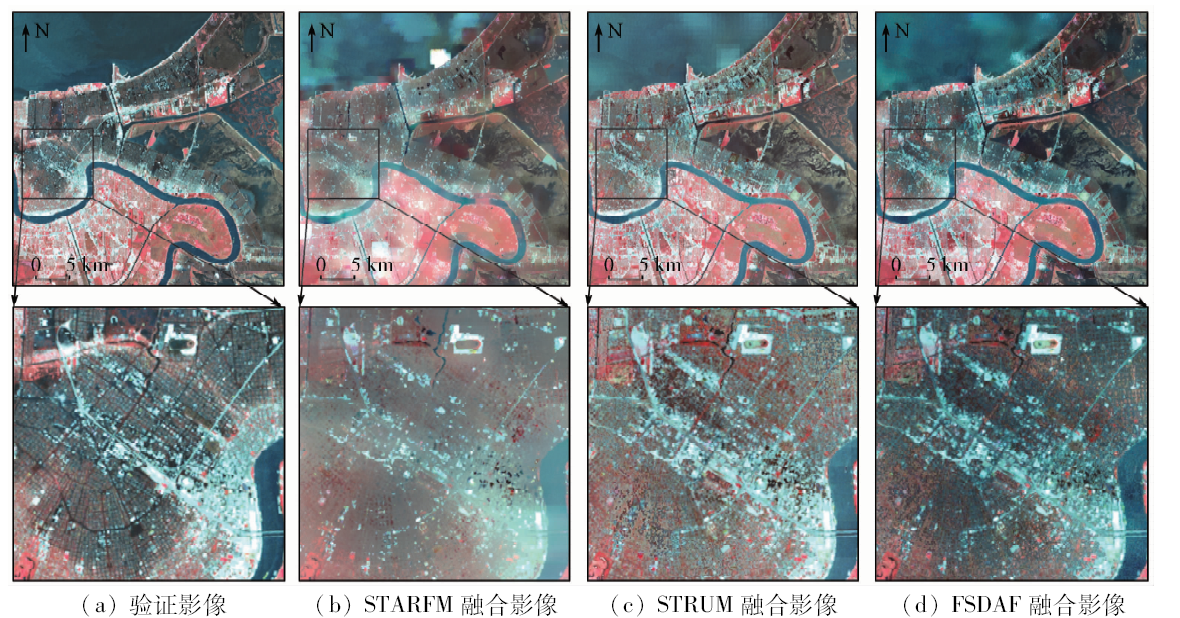
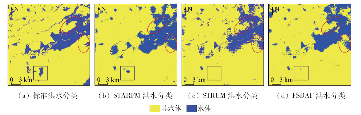
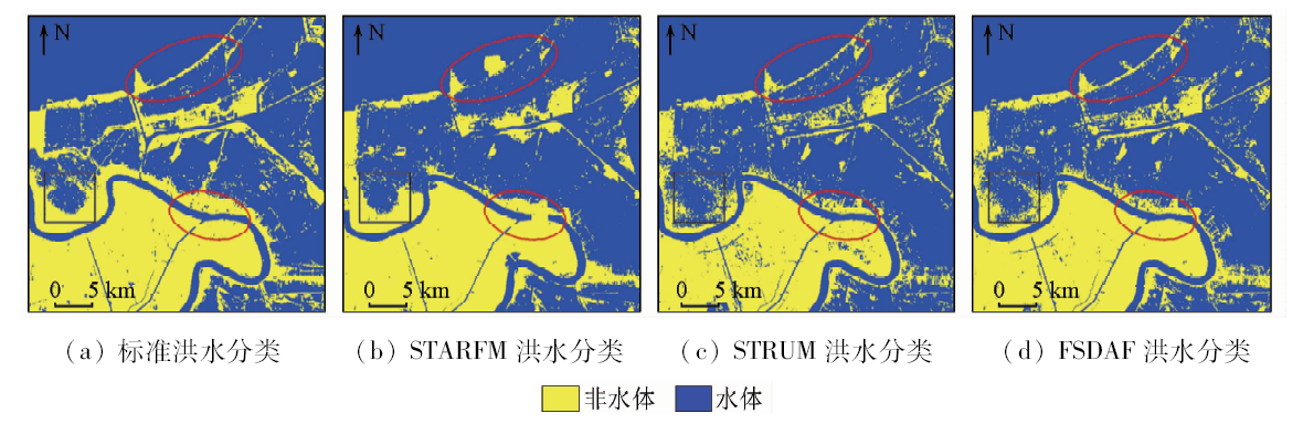
Abstract Remote sensing images with high spatiotemporal resolution offer a reliable way to the monitoring of flood disasters. However, the application of high spatial resolution images is restricted by satellite revisit period and extreme weather. Therefore, this paper proposes a method that can blend Landsat and MODIS images to generate high spatiotemporal images for monitoring flood disaster. Selecting Gwydir and the New Orleans as study areas, the authors performed fusion of MODIS and Landsat TM based on three major spatiotemporal fusion algorithms, i.e., the spatial and temporal adaptive reflectance fusion model (STARFM), the spatial and temporal reflectance unmixing model (STRUM) and the flexible spatiotemporal data fusion (FSDAF), which led to the formation of a new TM image. Meanwhile, classified flood information was extracted by applying support vector machine (SVM) to the new TM image. The results show that three spatiotemporal fusion algorithms can monitor flood disasters effectively, with FSDAF playing a more superior role in fusion accuracy and flood information extraction. Evaluation of flood classification shows that, in Gwydir, the overall accuracy of STARFM, STRUM and FSDAF is 0.89, 0.90, 0.91, and the Kappa coefficients are 0.63, 0.64, 0.67, respectively. In the New Orleans, the overall accuracy of three fusion algorithms is 0.90, 0.89, 0.91, and the Kappa coefficients are 0.77, 0.76, 0.81, respectively. This study shows that spatiotemporal fusion algorithms can be effectively applied to flood monitoring.
|
| Keywords
spatiotemporal fusion
flood monitoring
high spatiotemporal resolution
STARFM
STRUM
FSDAF
|
|
|
|
Corresponding Authors:
Xuhong WANG
E-mail: jqy_wxh@nwu.edu.cn
|
|
Issue Date: 18 June 2020
|
|
|
| [1] |
Sebastiano S, Silvana D, Giorgio B, et al. Information extraction from remote sensing images for flood monitoring and damage evaluation[J]. Proceedings of the IEEE, 2012,100(10):2946-2970.
|
| [2] |
Zhang F, Zhu X L, Liu D S, et al. Blending MODIS and Landsat images for urban flood mapping[J]. International Journal of Remote Sensing, 2014,35(9):3237-3253.
doi: 10.1080/01431161.2014.903351
url: https://www.tandfonline.com/doi/full/10.1080/01431161.2014.903351
|
| [3] |
Yu L, Sandro M, Simon P, et al. An automatic change detection approach for rapid flood mapping in Sentinel-1 SAR data[J]. International Journal of Applied Earth Observation and Geoinformation, 2018,73:123-135.
|
| [4] |
Marco C, Ramona P, Luca P, et al. Sentinel-1 InSAR coherence to detect floodwater in urban areas:Houston and hurricane harvey as a test case[J]. Remote Sensing, 2019,11(2):107.
|
| [5] |
李胜阳, 许志辉, 陈子琪, 等. 高分3号卫星影像在黄河洪水监测中的应用[J].水利信息化, 2017(5):22-26.
|
| [5] |
Li S Y, Xu Z H, Chen Z Q, et al. Application of GF-3 satellite remote sensing image on Yellow River flood monitoring[J].Water Resources Informatization, 2017(5):22-26.
|
| [6] |
Biswa B, Maurizio M, Reyne U. Flood inundation mapping of the sparsely gauged large-scale Brahmaputra basin using remote sensing products[J]. Remote Sensing, 2019. 11(5):501.
|
| [7] |
刘明月, 贾明明, 王宗明, 等. 2013年松花江与嫩江交汇段洪水遥感监测[J]. 湿地科学, 2015,13(4):456-465.
|
| [7] |
Liu M Y, Jia M M, Wang Z M, et al. Flood monitoring on the confluence of Nenjiang River and Songhua River in 2013 by multi-source,multi-temporal remote sensing imagery[J]. Wetland Science, 2015,13(4):456-465.
|
| [8] |
李斌, 燕琴, 张丽, 等. 长江中游洪涝灾害特征的MODIS时序监测与分析[J]. 武汉大学学报(信息科学版), 2013,38(7):789-793.
|
| [8] |
Li B, Yan Q, Zhang L, et al. Flood monitoring and analysis over the middle reaches of Yangtze River Basin with MODIS time-series imagery[J]. Geomatics and Information Science of Wuhan University, 2013,38(7):789-793.
|
| [9] |
饶品增, 蒋卫国, 王晓雅, 等. 基于MODIS数据的洪涝灾害分析研究——以2017年洞庭湖区洪水为例[J]. 灾害学, 2019,34(1):203-207.
|
| [9] |
Rao P Z, Jiang W G, Wang X Y, et al. Flood disaster analysis based on MODIS data——Taking the flood in Dongting Lake area in 2017 as an example[J]. Journal of Catastrophology, 2019,34(1):203-207.
|
| [10] |
Goldberg M, Li S M, Goodman S, et al. Contributions of operational satellites in monitoring the catastrophic floodwaters due to hurricane harvey[J]. Remote Sensing, 2018,10(8):1256.
|
| [11] |
Huang C, Chen Y, Zhang S Q, et al. Surface water mapping from suomi NPP-VIIRS imagery at 30 m resolution via blending with Landsat data[J]. Remote Sensing, 2016,8(8):631.
|
| [12] |
章欣欣, 栾海军, 潘火平. 一种基于多波段距离加权的遥感影像时空融合方法及其在洪水监测中的应用[J]. 自然灾害学报, 2015,24(6):105-111.
|
| [12] |
Zhang X X, Luan H J, Pan H P. A spatiotemporal remote sensing imagery fusion method based on multi-band distance weighted and its application to flood monitoring[J]. Journal of Natural Disasters, 2015,24(6):105-111.
|
| [13] |
董文全, 蒙继华. 遥感数据时空融合研究进展及展望[J]. 国土资源遥感, 2018,30(2):1-11.doi: 10.6046/gtzyyg.2018.02.01.
|
| [13] |
Dong W Q, Meng J H. Review of spatiotemporal fusion model of remote sensing data[J]. Remote Sensing for Land and Resources, 2018,30(2):1-11.doi: 10.6046/gtzyyg.2018.02.01.
|
| [14] |
黄波, 赵涌泉. 多源卫星遥感影像时空融合研究的现状及展望[J]. 测绘学报, 2017,46(10):1492-1499.
|
| [14] |
Huang B, Zhao Y Q. Research status and prospect of spatiotemporal fusion of multi-source satellite remote sensing imagery[J]. Acta Geodaetica et Cartographica Sinica, 2017,46(10):1492-1499.
|
| [15] |
Gao F, Masek J, Schwaller M, et al. On the blending of the Landsat and MODIS surface reflectance:Predicting daily Landsat surface reflectance[J]. IEEE Transactions on Geoscience and Remote Sensing, 2006,44(8):2207-2218.
|
| [16] |
Zhu X L, Chen J, Gao F, et al. An enhanced spatial and temporal adaptive reflectance fusion model for complex heterogeneous regions[J]. Remote Sensing of Environment, 2010,114(11):2610-2623.
|
| [17] |
Gevaert C M, García-Haro F, Javier.A comparison of STARFM and an unmixing-based algorithm for Landsat and MODIS data fusion[J]. Remote Sensing of Environment, 2015,156:34-44.
doi: 10.1016/j.rse.2014.09.012
url: https://linkinghub.elsevier.com/retrieve/pii/S0034425714003551
|
| [18] |
邬明权, 王洁, 牛铮, 等. 融合MODIS与Landsat数据生成高时间分辨率Landsat数据[J]. 红外与毫米波学报, 2012,31(1):80-84.
|
| [18] |
Wu M Q, Wang J, Niu Z, et al. A model for spatial and temporal data fusion[J]. Journal of Infrared and Millimeter Waves, 2012,31(1):80-84.
|
| [19] |
Wu P H, Shen H F, Zhang L P, et al. Integrated fusion of multi-scale polar-orbiting and geostationary satellite observations for the mapping of high spatial and temporal resolution land surface temperature[J]. Remote Sensing of Environment, 2015,156:169-181.
|
| [20] |
杨敏, 杨贵军, 陈晓宁, 等. 基于FSDAF方法融合生成高时空分辨率地表温度[J]. 国土资源遥感, 2018,30(1):54-62.doi: 10.6046/gtzyyg.2018.01.08.
|
| [20] |
Yang M, Yang G J, Chen X N, et al. Generation of land surface temperature with high spatial and temporal resolution based on FSDAF method[J]. Remote Sensing for Land and Resources, 2018,30(1):54-62.doi: 10.6046/gtzyyg.2018.01.08
|
| [21] |
Gao F, Hilker T, Zhu X L, et al. Fusing Landsat and MODIS data for vegetation monitoring[J]. IEEE Geoscience and Remote Sensing Magazine, 2015. 3(3):47-60.
|
| [22] |
蔡德文, 牛铮, 王力. 遥感数据时空融合技术在农作物监测中的适应性研究[J]. 遥感技术与应用, 2012,27(6):927-932.
url: http://www.rsta.ac.cn/CN/abstract/abstract2194.shtml
|
| [22] |
Cai D W, Niu Z, Wang L. Adaptability research of spatial and temporal remote sensing data fusion technology in crop monitoring[J]. Remote Sensing Technology and Application, 2012,27(6):927-932.
|
| [23] |
孙佩军, 张锦水, 潘耀忠, 等. 构建时空融合模型进行水稻遥感识别[J]. 遥感学报, 2016,20(2):328-343.
|
| [23] |
Sun P J, Zhang J S, Pan Y Z, et al. Temporal-spatial-fusion model for area extraction of paddy rice using multi-temporal remote sensing images[J]. Journal of Remote Sensing, 2016,20(2):328-343.
|
| [24] |
Zhu X L, Helmer E H, Gao F, et al. A flexible spatiotemporal method for fusing satellite images with different resolutions[J]. Remote Sensing of Environment, 2016,172:165-177.
|
| [25] |
Emelyanova I V, McVicar T R, Van Niel T G,et al.Assessing the accuracy of blending Landsat-MODIS surface reflectances in two landscapes with contrasting spatial and temporal dynamics:A framework for algorithm selection[J]. Remote Sensing of Environment, 2013,133:193-209.
|
| [26] |
Zhong D T, Zhou F Q. A prediction smooth method for blending Landsat and moderate resolution imagine spectroradiometer images[J]. Remote Sensing, 2018,10(9):1371.
doi: 10.3390/rs10091371
url: http://www.mdpi.com/2072-4292/10/9/1371
|
| [27] |
Zhu X L, Cai F Y. Spatiotemporal fusion of multisource remote sensing data:Literature survey,taxonomy,principles,applications,and future directions[J]. Remote Sensing, 2018,10(4):527.
|
|
Viewed |
|
|
|
Full text
|
|
|
|
|
Abstract
|
|
|
|
|
Cited |
|
|
|
|
| |
Shared |
|
|
|
|
| |
Discussed |
|
|
|
|
 2020,
Vol. 32
2020,
Vol. 32