|
|
 |
|

|
|
|
Pansharpening algorithm of remote sensing images based on NSCT and PCNN |
XU Xinyu1( ), LI Xiaojun1,2,3(), ZHAO Heting1, GAI Junfei1 ), LI Xiaojun1,2,3(), ZHAO Heting1, GAI Junfei1 |
1. Faculty of Geomatics, Lanzhou Jiaotong University, Lanzhou 730070, China
2. National-Local Joint Engineering Research Center of Technologies and Applications for National Geographic State Monitoring, Lanzhou 730070, China
3. Gansu Provincial Engineering Laboratory for National Geographic State Monitoring, Lanzhou 730070, China |
|
|
|
|
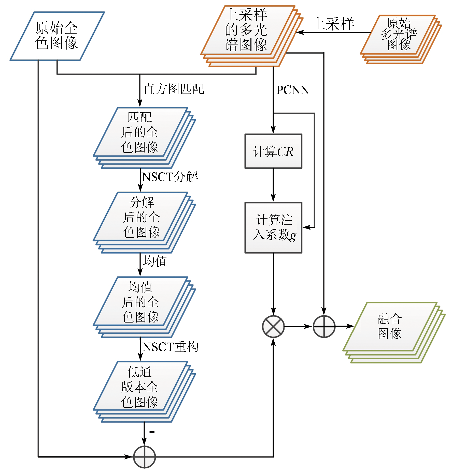
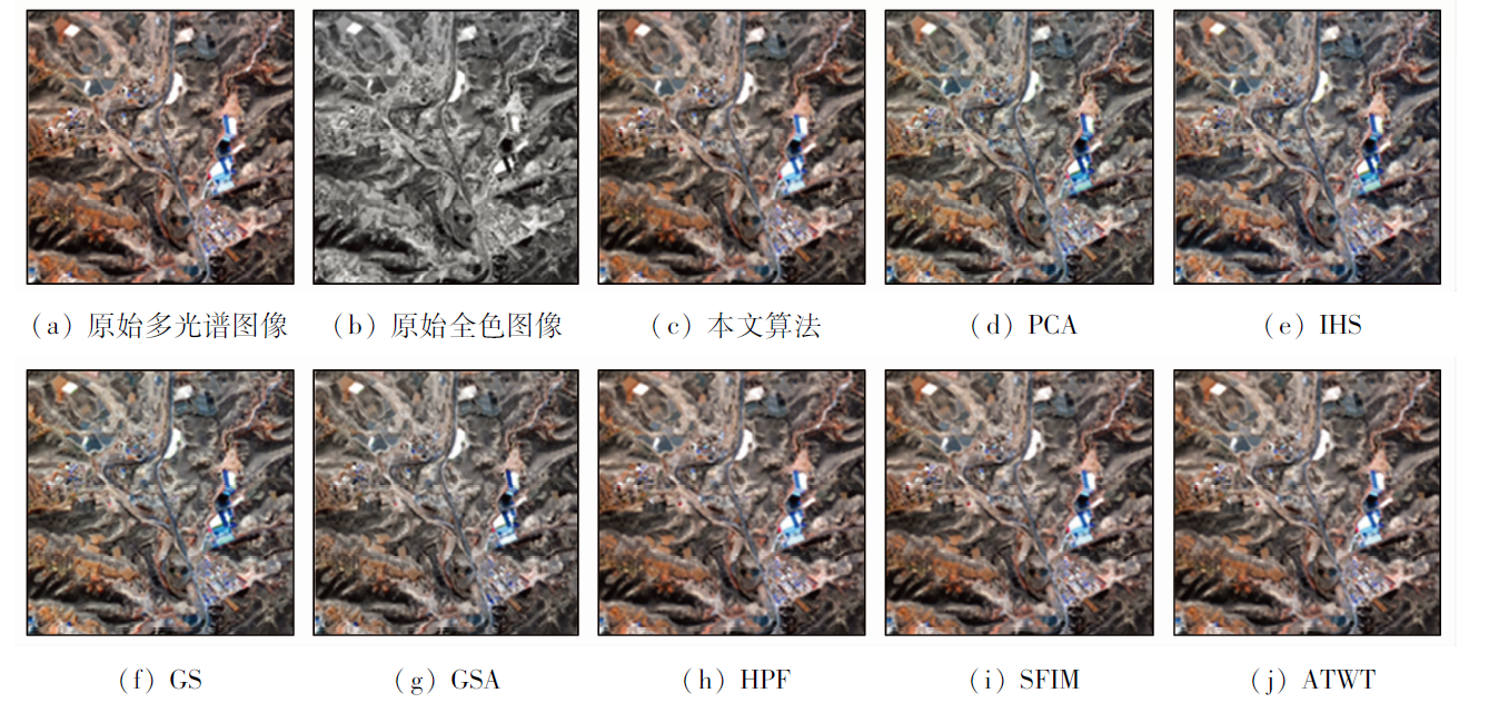
Abstract Conventional pansharpening fusion methods suffer inaccurate extraction of details and low spectrum fusion accuracy. This study proposed a pansharpening algorithm of remote sensing images based on nonsubsampled Contourlet transform (NSCT) and pulse coupled neural networks (PCNN) by combining the multi-scale and -directional decomposition characteristics of NSCT and the pulse synchronous emission characteristics of PCNN. The process of this pansharpening algorithm is as follows: first, the details of panchromatic images were extracted through NSCT; then, the extracted detail features were injected into the irregular segmentation regions obtained using the PCNN model; finally, the sharpening fusion results of high-resolution multispectral remote-sensing images were obtained through statistical weighting. As corroborated by the experimental results of WorldView-2 and GF-2 data sets, the pansharpening algorithm outperforms other remote sensing image fusion algorithms in detail preservation and spectral consistency, verifying its effectiveness.
|
| Keywords
pulse coupled neural network
nonsubsampled Contourlet transform
remote sensing image fusion
multispectral remote sensing image
|
|
|
|
Issue Date: 19 September 2023
|
|
|
| [1] |
杨丽萍, 马孟, 谢巍, 等. 干旱区Landsat8全色与多光谱数据融合算法评价[J]. 国土资源遥感, 2019, 31(4):11-19.doi:10.6046/gtzyyg.2019.04.02.
doi: 10.6046/gtzyyg.2019.04.02
|
| [1] |
Yang L P, Ma M, Xie W, et al. Fusion algorithm evaluation of Landsat8 panchromatic and multispetral images in arid regions[J]. Remote Sensing for Land and Resources, 2019, 31(4):11-19.doi:10.6046/gtzyyg.2019.04.02.
doi: 10.6046/gtzyyg.2019.04.02
|
| [2] |
Vivone G, Mura M D, Garzelli A, et al. A new benchmark based on recent advances in multispectral pansharpening:Revisiting pansharpening with classical and emerging pansharpening methods[J]. IEEE Geoscience and Remote Sensing Magazine, 2020, 9(1):53-56.
doi: 10.1109/MGRS.6245518
url: https://ieeexplore.ieee.org/xpl/RecentIssue.jsp?punumber=6245518
|
| [3] |
刘万军, 高健康, 曲海成, 等. 多尺度特征增强的遥感图像舰船目标检测[J]. 自然资源遥感, 2021, 33(3):97-106.doi:10.6046/zrzyyg.2020372.
doi: 10.6046/zrzyyg.2020372
|
| [3] |
Liu W J, Gao J K, Qu H C, et al. Ship detection based on multi-scale feature enhancement of remote sensing images[J]. Remote Sensing for Natural Resources, 2021, 33(3):97-106.doi:10.6046/zrzyyg.2020372.
doi: 10.6046/zrzyyg.2020372
|
| [4] |
Li H F, Song D Z, Liu Y, et al. Automatic pavement crack detection by multi-scale image fusion[J]. IEEE Transactions on Intelligent Transportation Systems, 2018, 20(6):2025-2031.
doi: 10.1109/TITS.6979
url: https://ieeexplore.ieee.org/xpl/RecentIssue.jsp?punumber=6979
|
| [5] |
宋亚萍. 基于多源影像融合和面向对象的土地利用分类技术研究[D]. 石河子: 石河子大学, 2020.
|
| [5] |
Song Y P. Research on land use classification technology based on multi-source image fusion and object-oriented[D]. Shihezi: Shihezi University, 2020.
|
| [6] |
Kahraman S, Erturk A. Review and performance comparison of pansharpening algorithms for RASAT images[J]. Istanbul University-Journal of Electrical and Electronics Engineering, 2018, 18(1):109-120.
doi: 10.5152/iujeee.
url: http://dergipark.gov.tr/iujeee
|
| [7] |
Wady S, Bentoutou Y, Bengermikh A, et al. A new IHS and wavelet based pansharpening algorithm for high spatial resolution satellite imagery[J]. Advances in Space Research, 2020, 66(7):1507-1518.
doi: 10.1016/j.asr.2020.06.001
url: https://linkinghub.elsevier.com/retrieve/pii/S0273117720304014
|
| [8] |
Du C, Gao S. Remote sensing image fusion based on nonlinear IHS and fast nonsubsampled contourlet transform[J]. Journal of the Indian Society of Remote Sensing, 2018, 46(6):2023-2032.
doi: 10.1007/s12524-018-0859-y
|
| [9] |
Wu Z, Huang Y, Zhang K. Remote sensing image fusion method based on PCA and Curvelet transform[J]. Journal of the Indian Society of Remote Sensing, 2018, 46(5):687-689.
doi: 10.1007/s12524-017-0736-0
url: http://link.springer.com/10.1007/s12524-017-0736-0
|
| [10] |
张涛, 刘军, 杨可明, 等. 结合Gram-Schmidt变换的高光谱影像谐波分析融合算法[J]. 测绘学报, 2015, 44(9):1042-1047.
doi: 10.11947/j.AGCS.2015.20140637
|
| [10] |
Zhang T, Liu J, Yang K M, et al. Harmonic analysis fusion algorithm for hyperspectral image combining Gram-Schmidt transform[J]. Journal of Surveying and Mapping, 2015, 44(9):1042-1047.
|
| [11] |
Aiazzi B, Baronti S, Selva M. Improving component substitution pansharpening through multivariate regression of MS+Pan data[J]. IEEE Transactions on Geoscience and Remote Sensing, 2007, 45(10):3230-3239.
doi: 10.1109/TGRS.2007.901007
url: http://ieeexplore.ieee.org/document/4305344/
|
| [12] |
Nunez J, Otazu X, Fors O, et al. Multiresolution-based image fusion with additive wavelet decomposition[J]. IEEE Transactions on Geoscience and Remote Sensing, 1999, 37(3):1204-1211.
doi: 10.1109/36.763274
url: http://ieeexplore.ieee.org/document/763274/
|
| [13] |
Ma D, Lai H C. Remote sensing image matching based improved ORB in NSCT domain[J]. Journal of the Indian Society of Remote Sensing, 2019, 47(5):801-807.
doi: 10.1007/s12524-019-00958-y
|
| [14] |
王密, 何鲁晓, 程宇峰, 等. 自适应高斯滤波与SFIM模型相结合的全色多光谱影像融合方法[J]. 测绘学报, 2018, 47(1):82-90.
doi: 10.11947/j.AGCS.2018.20170421
|
| [14] |
Wang M, He L X, Cheng Y F, et al. Panchromatic multispectral image fusion method based on adaptive Gaussian filter and SFIM model[J]. Journal of Surveying and Mapping, 2018, 47(1):82-90.
|
| [15] |
Cunha A L, Zhou J, Do M N, et al. The nonsubsampled Contourlet transform:Theory,design,and applications[J]. IEEE Transactions on Image Processing, 2006, 15(10):3089-3101.
doi: 10.1109/TIP.2006.877507
url: http://ieeexplore.ieee.org/document/1703596/
|
| [16] |
Eckhorn R, Frien A, Bauer R, et al. High frequency (60-90 Hz) oscillations in primary visual cortex of awake monkey[J]. Neuroreport, 1993, 4(3):243-246.
pmid: 8477045
|
| [17] |
李凯. 基于PCNN和图像分块融合法的多聚焦图像融合算法研究[D]. 昆明: 云南大学, 2013.
|
| [17] |
Li K. Research on multi-focus image fusion algorithm based on PCNN and image block fusion method[D]. Kunming: Yunnan University, 2013.
|
| [18] |
Ding S, Zhao X, Hui X, et al. NSCT-PCNN image fusion based on image gradient motivation[J]. IET Computer Vision, 2018, 12(4):377-383.
doi: 10.1049/cvi2.v12.4
url: https://ietresearch.onlinelibrary.wiley.com/toc/17519640/12/4
|
| [19] |
马冯. 基于NSCT变换的遥感图像融合算法研究[D]. 西安: 长安大学, 2019.
|
| [19] |
Ma F. Research on remote sensing image fusion algorithm based on NSCT transform[D]. Xi’an: Chang’an University, 2019.
|
| [20] |
闫利, 向天烛. NSCT域内结合边缘特征和自适应PCNN的红外与可见光图像融合[J]. 电子学报, 2016, 44(4):761-766.
doi: 10.3969/j.issn.0372-2112.2016.04.002
|
| [20] |
Yan L, Xiang T Z. Infrared and visible image fusion based on edge feature and adaptive PCNN in NSCT domain[J]. Journal of Electronics, 2016, 44(4):761-766.
|
|
Viewed |
|
|
|
Full text
|
|
|
|
|
Abstract
|
|
|
|
|
Cited |
|
|
|
|
| |
Shared |
|
|
|
|
| |
Discussed |
|
|
|
|
 2023,
Vol. 35
2023,
Vol. 35